Transcription
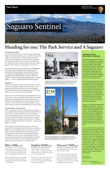
Park NewsNational Park ServiceU.S. Department of the InteriorSaguaro SentinelHeading for 100: The Park Service and A SaguaroTWO SEEDS ARE PLANT ED1916. In the Sonoran Desert, far to the east of the sleepyvillage of Tucson, a saguaro cactus seed fell to the groundunder a palo verde tree. Perhaps it slipped from thebeak of a gila woodpecker, or arrived in the droppingsof a nectar-feeding bat. Before the seed could dry up,two rainstorms swept the desert within five days. Thus asaguaro cactus was born in the shade of a nurse tree.PREPARING FOR THEPARK SERVICE CENTENNIAL!1966Welcome to Saguaro National Park!You are visiting during a very specialtime for us and the entire NationalPark Service (NPS). From AcadiaNational Park to Martin Luther KingJr. National Historic Site; from Yellowstone National Park to César E.Chávez National Monument, weare joining over 400 National Parkunits across the country to celebratethe 100th anniversary of the NPS in2016 and we’re starting now!Meanwhile on the East Coast, in the busy city of Washington,D.C., another seed was planted when Congress passedand President Wilson signed the National Park Service Act.This new law provided an agency to oversee 37 parks andmonuments scattered from Maine to Hawaii. Now therewould be a cadre of rangers and a visionary director -- StephenMather -- to care for and develop these national treasures.GROWING UPThese two birthdays became entwined in 1933. In Marchof that year a group of Tucson citizens convinced outgoing President Herbert Hoover to proclaim SaguaroNational Monument, including the home of that youngsaguaro cactus, now about ten inches high.A saguaro growing outside the Rincon Mountain Visitor Centerwas designated the Anniversary Saguaro in 1966 as the ParkService, and the cactus, turned 50 years old. NPS fle photo.At first, the new monument was administered by the U.S.Forest Service, but a new Parks director, Horace Albright,appealed to incoming President Franklin Roosevelt totransfer all National Monuments and a grand collectionof historic areas to Park Service care in August of 1933.This created the system of parklands that we know today.The goal of the National Park ServiceCentennial in 2016 is to “connectwith and create the next generationof park visitors, supporters, and advocates”. Over the next few years,we will be looking to engage moreyouth, fnd greater connections tothe increasingly-urban communityof Tucson, and raise the visibility ofthe park. We want to engage newstewards that will help care for andprotect this place for generations tocome.CHANGE, GROWTH, AND TH E FU TURE1966. The saguaro. now fifteen feet tall, was carefullytransplanted at the Monument’s Rincon Mountain Districtvisitor center (a Tucson Mountain District 35 miles tothe west was added in 1961.) At the same time, the ParkService celebrated its 50th anniversary with a programof improvements to facilities called Mission 66. Visitorsfound new exhibits inside and a centerpiece “AnniversarySaguaro” outside.As we approach the passage of another 50 years, thesaguaro, its surroundings, and the system have all grown.Stop by to see the saguaro today. Then enjoy 140 squaremiles of Saguaro National Park (re-named in 1994,)east and west. And join with us all around the countryto celebrate 100 years of your National Park Service,preserving the natural and cultural heritage of Americain over 400 sites, and in scores of regional and localprojects. Join the celebration -- Find Your Park!Take a Hikepg 3The park and the entire Tucson areahave changed dramatically over thelast 100 years. Can you predict whatthis area will look like in 2116? Willthe next generation still care aboutnational parks and wilderness areas?What impacts will climate changehave on the American west’s iconicsaguaro cactus, the namesake of thispark? Will these places be valuedenough to ensure the continuedprotection of our precious naturaland cultural resources?The Anniversary Saguaro as it looks today, with the Park’sSuperintendent Darla Sidles. This cactus has grown three armsand about twenty feet in the past ffty years. NPS photo.Explore RMD pg 4Are you visiting us for an hour or for acouple of days? Are you with small childrenor a super-athlete ready to test your endurance? No matter what your skill or ftnesslevel, we can suggest an adventure for you.Take some time to explore the RinconMountain District on the east side ofTucson. There is a map and some helpfuladvice about how to make the best use ofyour time during your visit.Use this hiking guide as your starting place,but we always encourage you to check themost recent trail conditions with our staff atthe visitor centers.Drive the scenic Cactus Forest Loop. Hikeamong the saguaros or up toward thepines. You can even ride a mountain biketo an historic ranching site.Discover TMD pg 6Discovering the Tucson Mountain Districton the west side of Tucson is easy with alittle help from this guide.Drive or hike a scenic trail. Climb a hill tosee one of the most popular petroglyphsites in southern Arizona. Enjoy a sunsetbehind the iconic silhouette of our namesake saguaro cactus. There are many waysto experience this amazing place.Be on the lookout for special Centennial activities and events that willcelebrate our last 100 years and prepare us for the next 100 years. Askpark staff and volunteers how youcan help—there are many differentopportunities! You can volunteer,help get youth engaged, participatein park events, assist in raising thevisibility of the park, or contributefinancially. Check out our websiteat www.nps.gov/sagu, and our Facebook page for updates. Our futuredepends on YOU! Thanks for yoursupport, and for visiting SaguaroNational Park.Darla SidlesSuperintendent(By the way, we pronounce it:“sah-WAH-row.”)
National Park ServiceU.S. Department of the InteriorSaguaro National ParkSaguaro National Park preserves andprotects thousands of acres ofSonoran Desert wilderness,offering recreation, learning, andspiritual renewal in the backyard of agrowing metropolitan city.SuperintendentDarla SidlesHeadquarters AddressRincon Mountain District (East)Saguaro National Park3693 South Old Spanish TrailTucson, AZ 85730(520) 733-5153Tucson Mountain District (West)2700 N. Kinney RoadTucson, AZ 85743(520) 733-5158Park Information(520) 733-5100Fax(520) 733-5183E-mailSAGU n CoordinatorChip Littlefeld@nps.gov(520) 733-5157Volunteer CoordinatorRichard Hill@nps.gov(520) 733-5156Community Outreach CoordinatorEsther Rivera@nps.gov(520) 733-8613The National Park Service caresfor the special places saved by theAmerican people so that all mayexperience our heritage.Find us on Facebook asSaguaroNationalParkThe Other Side of Saguaro.Welcome to Saguaro National Park,where you will fnd one park withtwo districts found east and west ofTucson. While they are both SaguaroNational Park and they were both setaside primarily to protect saguarocacti, they are very diferent places foryou to enjoy.WHY TWO DISTRICTS?What is now known as SaguaroNational Park was frst established asa national monument in 1933. HomerShantz from the University of Arizonaworked to preserve a remarkable standof saguaro cacti on the east side of townand the result of his eforts became theRincon Mountain District (RMD).In the 1960s, researchers noticed adecline in the number of cacti in theRincon’s cactus forest and workedtogether to add another remarkablestand of cacti found on the western sideof Tucson to the park. This westernarea is now known as the TucsonMountain District (TMD) of SaguaroNational Park.TUCSON MOUNTAIN DISTRICT(TMD) is located on the west side oftown, just northwest of the ArizonaSonora Desert Museum, anotherpopular destination for Tucson visitors.Seeing both together in one day iscommon, though it makes for a verylong day. Save some time to really slowdown and enjoy TMD. There are hikesfor people of all abilities, awe inspiringstands of cacti, and a brilliant view ofthe western sky from sunset to star rise.The historic CCC-built picnic areas aremarvelous places to stop for a snackbefore hitting the trail, and SignalHill picnic area is the starting place tomarvel at ancient petroglyphs found onSignal Hill. A 5-mile scenic loop driveleads to many of these sites.the time to look for them. This roadis also a popular biking destination,not for the faint of heart. North of thevisitor center is a network of trails thatwind all over the cactus forest. It is easyto plan a hike that will last an hour or aday. If you want to plan a hike for morethan one day, RMD is your district.There are 6 diferent back countrycampgrounds, the only camping in thepark, that vary from grasslands withjuniper trees at 4,800’ in elevation to thepine and fr forests above 8,000’. RMDprotects the western and southernslopes of the Rincon Mountains.THE WHOLE PARKWhat the two districts do well togetheris serve our visitors. During the monthsof December through March, you willfnd scheduled programs several timeseach day. During our warm springs andhot summers, there is still somethinghappening each day in the visitor centersof both districts. Interpretive programs,guided hikes and Jr. Ranger programsare designed to help visitors make theirown meaningful memories of theiradventures in Saguaro National Park.Travel time between the two districts isapproximately one hour. We hope yousave time on your trip to drive to theother side of town to see the other sideof Saguaro National Park.DirectionsTo Rincon Mountain District (East)From the Tucson Mountain District, headsoutheast on Kinney Road, to Gates PassRoad. Turn left and go up and over thepass. Caution - large vehicles are notpermitted over Gates Pass, see belowfor an alternate route. Gates Pass Roadbecomes Speedway Boulevard. Continueeast on Speedway for 14 miles through thecity to Freeman Road. Turn right (south) 3.6miles to Old Spanish Trail. Turn left (east)following the signs .25 miles.To Tucson Mountain District (West)From the Rincon Mountain District,head northwest on Old Spanish Trail toHarrison Road. Turn right and followHarrison to Speedway Boulevard. Headwest on Speedway for 14 miles. This willbecome Gates Pass Road. Caution - largevehicles are not permitted over GatesPass, see below for an alternate route.Continue 4.6 miles west through the TucsonMountains to Kinney Road. Turn right(northwest) and follow Kinney Road 3.7miles past the Desert Museum to the parkentrance. Go 1 mile to the visitor center.Over-sized Vehicles (West)Vehicles exceeding 12,000 poundsGVWR are prohibited on Gates Pass Roadand Picture Rocks Road through the park.Instead, use I-10 to I-19 (exit 260) south.From I-19 take Ajo Way/State Route 86 (exit99) west 4.8 miles to Kinney Road. Turnright (north) 10 miles (past Old Tucson Studios and the Desert Museum) to the visitorcenter. Going to Rincon Mountain District,take I-10 to Houghton Road north. At Escalante Road turn east and follow the signs.Travel Between Rincon Mountain and Tucson Mountain DistrictsTHE RINCON MOUNTAIN DISTRICT(RMD) has an 8-mile loop drive worthwriting home about. This windingscenic road takes visitors through thehistoric cactus forest, where there aresigns of signifcant recovery of thecactus population for anyone who takesPlan Your VisitIn Case of an Emergency, call 911, then contact a ranger.If you see crimes against resources call 1-800-637-9152.Dates and Hours of OperationBoth district scenic drives are open daily from sunrise to sunset. Visitor centers are open 9:00 a.m.to 5:00 p.m. daily, year-round, except December 25.Entrance FeesPrivate vehicles and motorcycles. 10.00 Valid for 7 daysBicyclists and pedestrians. 5.00 Valid for 7 daysCamping is not available in Saguaro National Park. Consider Gilbert Ray Campground onKinney Road inside Tucson Mountain Park when visiting Tucson Mountain District. Colossal CaveMountain Park or other commercial campgrounds are near the Rincon Mountain District. Thepark website has a list of public campgrounds. Backcountry camping is available with a permitfrom the Rincon Mountain Visitor Center: see “Hiking in the High Country” on pg. 5.Hiking is permitted on more than 150 miles of designated trails. Off-trail hiking is onlypermitted in areas above 4,500’ elevation. Purchase topographic maps at Visitor Centers.Food and Lodging are not available inside the park. Tucson has many restaurants,grocery stores and opportunities for lodging near both districts.Saguaro Annual Pass . 25.00* Valid for 1 yearFires are permitted in grillsInteragency Annual Pass. 80.00 Valid for 1 yearGrills are provided at most picnic areas in the park. Do not collect or burn any wood from insidethe park. Please be responsible; do not leave fres unattended and ensure the fre is completelyout cold before departing the area.Interagency Senior Pass (U.S. resident, 62 or older). 10.00 Valid for a lifetimeInteragency Access Pass (U.S. resident, disabled).Free Valid for a lifetimeInteragency Active Military Pass. Free Valid for 1 year(Active U.S. Military and Dependents)* Subject to change.Pets are welcome on all roads accessible to the public, picnic areas (other than Mam-A-Gah),and paved trails. For the safety of your pet, they must remain leashed at all times. Do not leavepets unattended in a vehicle. Even when outside temperatures are cool, car temperatures canquickly rise to dangerous levels. Watch carefully for snakes or other wildlife on roadways. Carry acomb and tweezers to remove cactus spines from paws and noses. Pavement can get very hot inthe afternoons and can burn paws. Pets are not permitted on unpaved trails. Visitor Centerstaff can suggest nearby areas for hiking with pets.2 Saguaro SentinelGroup Picnic areas are available in both districts. The Javelina Picnic Area ramada (no tables)in Rincon Mountain District (RMD - East) is the only group site available to be reserved. All otherpicnic grounds are frst-come, frst-served.Special Use Permits are available for special events or commercial activities inside thepark. Contact (520) 733-5116 for additional information.Travel Information
Take a Hike in the ParkRincon Mountain DistrictHiking TrailsTucson Mountain DistrictHiking TrailsTrail Description, Map on Page 612345Desert Discovery TrailYou will fnd the trailhead to this self-guided nature walk on KinneyRoad, one mile northwest of the Red Hills Visitor Center. Here you canfamiliarize yourself with the native plants, animals and ecology of theSonoran Desert. An audio tour for the visually impaired is available atthe visitor center. Trail has frequent benches, and is paved andwheelchair accessible.Valley View OverlookThis trail was built by the Civilian Conservation Corps (CCC) in the1930s. The trailhead is located 1.34 miles along the Bajada Loop Drive.While hiking this trail, you will cross two washes and then graduallyascend stone steps to a ridge. The view from the ridge includes AvraValley sprawled below and Picacho Peak to the north.Signal Hill TrailThis short climb takes you to dozens of ancient petroglyphs more than800 years old. The trail starts from the Signal Hill Picnic Area locatedoff Golden Gate Road, at 3.3 miles along the Loop Drive. The trailclimbs numerous stone steps, some of which have a large rise, througha wash and up a hill. For some, climbing these steps may be diffcult.King Canyon TrailThe trailhead and parking area for this hike is directly across the roadfrom the Arizona-Sonora Desert Museum. From the Red Hills visitorcenter, travel two miles southeast on Kinney Road. The frst section ofthe trail follows an old roadway constructed by the CCC in the 1930s.At .9 mile hikers pass the Sendero Esperanza trail junction at the MamA-Gah picnic area. The next 1.9 miles climbs to the Sweetwater Trailjunction. The fnal .9 mile ascends a series of steep switchbacks to theHugh Norris Trail. From here, continue .3 mile to reach the top of Wasson Peak, elevation 4,687 feet.Sendero Esperanza TrailThis trail begins 1.2 miles from the intersection of Golden Gate andHohokam Roads, across from the Ez-Kim-In-Zin picnic area. The trail’sfrst mile follows the sandy path of an old mine road. The next .7 mileclimbs a series of steep switchbacks to the top of a scenic ridge, whereit intersects the Hugh Norris Trail. The trail then descends 1.4 miles tothe south, past the Gould Mine Trail junction, where it meets the KingCanyon trail.67Hugh Norris TrailThis is the longest trail in the Tucson Mountain District. The trailheadis .8 mile from the start of the Bajada Loop Drive. The trail begins witha series of switchbacks that climb to a ridge overlooking the cactusforest. From there, the trail follows the ridge-top through areas withunique welded tuff rock formations until it reaches Amole Peak, approximately 4.1 miles from the trailhead. From here, continue .8 mileup a series of switchbacks to the top of Wasson Peak, the highestpoint in the Tucson Mountains.8Scenic Loop and Belmont Area TrailsThere is limited access and parking in these areas. Pleasecontact the visitor center or visit the website for detailedinformation about where to park to access these areas.Tucson Mountain District, looking up towards Wasson Peak - Bill MegnaTimes and distancesare roundtrip.Trail Description, Map on pages 4 and 5easy1.5 mile/.8 kmno elevation gain20 minuteseasy to moderate.8 mile/1.3 km100 ft./30 m.elevation gain245 minuteseasy.3 mile/.8 kmapprox. 30 ft./9 m.elevation gain320 minutesmoderate/strenuous47 miles/11.3 km1839 ft./561 m.elevation gain4-5 hoursmoderate56.2 miles/10 km700 ft./213 m.elevation gain3-4 hoursstrenuous610 miles/16 km2087 ft./636 m.elevation gain5-6 hours7Desert Ecology TrailTimes and distancesare roundtrip.easyThis trail offers an introduction to the rugged climate of theSonoran Desert and the adaptations that allow plants and animalsto thrive here. An easy and pleasant way to take a break from yourautomobile tour. Trail has interpretive signs, frequent benches, andis paved and wheelchair accessible.20 minutesFreeman Homestead Traileasy to moderateA scenic and historic path to the site of an early desert homestead.Full color interpretive signs along the trail explain the various aspectsof human and animal lives in this rugged “Home in the Desert.” Theunpaved trail has wide rock stairways on some moderate grades.1 mile/1.6 km100 ft./30 m.elevation gainMica View Picnic Area “Loop”Begin this walk through a natural desert garden at the Mica ViewPicnic Area, off the Cactus Forest Loop Drive. The route follows theMica View Trail north or south, connecting with the Cactus ForestTrail for the return trip. Use the trail map in this paper to follow thetrails in this area. This is the easiest loop in this trail system; it mayalso be reached from the trailhead at the east end of BroadwayBoulevard.Loma Verde “Loop”A scenic introduction to the Cactus Forest trail system. Begin at theLoma Verde trailhead on the Cactus Forest Drive. Follow the LomaVerde Trail past the site of a failed copper mine. From the Pink HillTrail take the short spur to the hilltop overlook for a spectacularview of the cactus forest. Continue following the Pink Hill Trail toSqueeze Pen Trail, and turn right. This trail will take you along thebase of the Rincon Mountains, back to Loma Verde Trail. Turn leftto return to your car. Easy grades on unpaved trails.Douglas Spring Trail to BridalWreath Falls.25 mile/.4 kmno elevation gain1 houreasy2 miles/3.2 kmno elevation gain1 houreasy3.4 miles/5.5 km70 ft./21 m.elevation gain2 hoursstrenuousThis trail begins at the Douglas Spring Trailhead at the east endof Speedway Boulevard. This trip into the foothills of the Rinconsprovides good views of the Santa Catalina Mountains. Along theway seasonal water courses add interest to the scenery, whichchanges from saguaro stands to desert grasslands. Bridal WreathFalls is a good lunchtime destination: the amount of water variesfrom a trickle to a torrent, depending on season and droughtconditions. Steep and rocky.5.6 miles/ 9 km1100 ft./335 m.elevation gainTanque Verde Ridge TrailstrenuousFor the visitor looking for a more rugged trail, the Tanque VerdeRidge Trail is ideal. Day hikers may climb as high as time allows,remembering to return to their cars by sunset to exit the park beforethe road closes. Magnifcent views of the Tucson Basin and RinconPeak are the reward. This trail is also the closest access to thebackcountry from the Visitor Center. Very steep and rocky.3-4 hours18 mi./29 km to peak14 mi./22.5 km toJuniper Basin4000 ft./1219 m.elevation gainCamping only at Juniper Basin, permit required.time varies accordingto destinationHope Camp TrailmoderateThis trail heads east from the Loma Alta Trailhead, following ariparian, or streamside, area. It offers views of Tanque Verde Ridgeand Rincon Peak. This trail passes two abandoned line camps withwindmills, water towers and storage tanks. (This trail connects tothe Arizona Trail via the Quilter Connection trail. It also connectswith Ruiz and Coyote Wash Trails.)5.6 miles/9 km300 ft./90 m.elevation gain3-4 hoursRincon Mountain District, along the Cactus Forest Drive - NPS photoSaguaro Sentinel 3
Explore theRincon MountainDistrict (East)RinconMountainDistrict (East)5 !Do!!!!1.2!!!!1.40.3stFore 0.8!2.3!!!!!!!!Manning Cam p!!!! !owa ney!!!!!!!!!!!1.9!!!!!! !0.8pLo o!Cactus!!! !!! !!! ! ! ! !!!!!!!!!!!!rilteQu!4.8Official Informationand parkingA Access Point!View0.8Ruiz0.72.1North CoyoteWashhTrai1.9RidgeSpanis0.1lA!Th eA!ilona Tr aÈ!0.4izArSaguaro WildernessOld!am pNorthi001 Kilometer1 MileCamino Loma AltaSee Restrictions3142ft/958m0.90.7! ! ! !7 TLoma Altaamp0.5Cpe! ! ! !Horse Trailer ParkingUniversal AccessRestroomsPicnic AreaInterpretive TrailTrailsTrails, stock prohibitedTrails, ADATrails, multi -useThe Arizona TrailRoad, PavedRoad, UnpavedRoad, 4WD recommendedScenic DrivePrivately Owned LandsPima County LandState Trust LandeCHopHo!Êb!!!5!ÖNo official informationor parking.Rd )ch cessnRa lic AcX9 Pubo(NHiking in the Cactus ForestHikingThere are many trails with multiple combinations in the CactusForest. It is easy to plan a hike lasting an hour or a whole day.Stop into the Rincon Mountain Visitor Center for triprecommendations and additional maps.Carry plenty of water. On hot days, one gallon or more per personis a necessity. Use sunscreen, wear a hat and sturdy footwear. Tellsomeone your plans and when you expect to be back.Hiking Restrictions The Cactus Forest has many trails available to hikers and horseback riders.4 Saguaro SentinelpNATIONAL!!!6.9!!!eRi d !! !Grass Shack!!!!!Freeman Rd.!!!!0.7!!Juniper Basin6 !0.9!!oneway!4.3!!!deVer!equTan!Dr iv e0.9!Spring!!le3.3!s!2 !!all3116ft950m! ! ! !!eF!Ö! FreemanHomestead!!Ca ctu s F or estL imRidgeRid geTanque Verde!! !dSad!Tanque Verde Peak !7049ft/2149m!!5JavelinaTanqueVerdeT!!Co w h eadCow Head Saddle6170ft/1881m! !SAGUARO4 onewayForestNorth0.3! Little WildhorseTankT Loma Verde!0.7LegendA!! Ranger Station@] Visitor Information!² Water Available!T Trailhead!Helen8269fglasD ouT Cactus!twwa oyCactusForestTSouth !Irvington Rd." Mica Tank!0.60.6§ To 10 Exit 275Douglas Spring! 4694ft/1431m9" Tina Larga Tank!!Javeli naEast Wash"Escalante Rd.6.4Garwood"Dam!0.2110º 44' 11" W32º 10' 49" N3090ft/942mThr ee Ta nk!5!3 1 @ !²!! tRincon !]Visitor CenterringDo u0.3 !BridalWreathFallsFOR ES T" Steel TankMicaViewilNATIONAL1.5T2768ft/844m !JavelinaWest Wash0.2Aguila Tank "BroadwayBroadway Blvd.E rnieu glas Spring! Ernie's FallssSp!!A!Spanish TraOld's Falls!To downtown TucsonCORONA DOA!!g laDouglas Spring2737ft/834m !!T T 2752ft/839m0.6!Wildhorse ÈA!Speedway Blvd.Hiking groups are limited to a maximum of 18 persons on trailsand 6 people if of-trail.Hiking of-trail in the Cactus Forest and Rincon Valley isprohibited. Hiking of-trail is permitted above 4,500 feet.Overnight camping is not permitted in the Cactus Forest.Hiking in the Cactus Forest is an excellent way to get up close and personalwith saguaro cacti - NPS Photo, B. Riley4.2
TA!Cactus Forest Loop Drive1.4East Slopevil's Batht ub0.51.2Restrictionsy Crke e e kA!3.1BikingAlways maintain a safe speed for road conditions and your own riding experience. TheLoop Drive is narrow with many tight turns and steep hills. Use extra caution whenapproaching the frst steep downhill after passing the entrance station! Bicyclistsmust obey all posted speed limits and give right of way to all pedestriatns. Watch for slowmoving cars or cars stopped in the roadway.De e20.40.4De0.10.57941ft/2420m0.8CampbartHe1.8Rid g ereak1.7T Turkey Creek!4623ft/1409mHappy Valley!4408!! !!ille!!Multi-use trail!!!1.3! Happy Valley90.5Trail riding is also permitted on the Hope Camp Trail from the Camino Loma AltaTrailhead, but is not permitted on the Quilter Trail, Ruiz or Coyote Wash trails.!!6117ft/1864m35)Miller Creek !T4199ft/1280mkCreeThe portion of the Cactus Forest Trail inside the Cactus Forest Loop Drive and the HopeCamp Trail are open to horseback riding, bicycling and hiking.Mexicanspotted owl7.4RinconValleyStock and Pack AnimalsHappy3.3PeakRd.Stay Alert! Make your presence known to other trail users well inadvance, particularly when approaching from behind. Cyclists yieldto all other trail users and hikers yield to equestrians.Horseback riding of-trail is prohibited. Livestock is restricted from the Cactus ForestLoop Drive and these trails:!Wildhorse Trail south of the Carrillo Trail!!!Rincon Peak!8482ft/2585mTanque Verde Ridge Trail! !Rinc !A!!!!!!2.6!!!M!1.8onr C!r!ee k! !Mountain BikingTrail riding is permitted on the 2.5 mile (4.0 km) multi-use portion of the Cactus ForestTrail inside the Cactus Forest Loop Drive. The trail maybe ridden in either direction, butyou maynot ri de against trafc on the one-way section of the Cactus Forest Loop Drive.A Lookout!PARK8 Feet35 Feet9 7359ft/2243m!0.41.0Spud Rock0.9r h ead S0.59 Manning!! Reef Rock8103ft/2470m0.10.2Mic0.50.5The Cactus Forest Scenic Loop Drive, highlighted in yellow on the map, in the RinconMountain District is a paved, combination one and two-way road. The 8-mile (12.9 km)Loop Drive features several trailheads, scenic vistas and pullouts. Trailers longer than 35feet or any vehicle wider than 8 feet are not permitted.Mica Meadow0.5Loo0.2RI N C O NWI L D E R N E S STura0.2pringMt0.80.7n.0.6p0.60.6hSlon Sp0.2Firegns Dome !ft/2520m0.1 !Loop0.4Spud Rock!FirenitaBo 0.7Spud Rock8613ft/2625m2.4ri nN o rtMica RepeaterDriving the LoopItalia1.7peDesert Ecology Trail! Wrong Mountain8056ft/2455m35)Freeman Homestead TrailMiller Creek TrailLast half mile of the Rincon Peak TrailConverse TrailCORONA DONATIONALFOR ES TFirst quarter mile of the Douglas Springs TrailHorse Trailer Parking is available at Wildhorse Trailhead and .4 mile (.6 km) south of theLoma Alta trailhead near Oro Escondido.Hiking in the High Country ofthe Rincon MountainsBackpacking in the east district’s higher elevations requires special preparation.Backpacking and CampingWaterOvernight camping is permitted, with a backcountry permit, in designated campgrounds inthe Rincon Mountain District. Campgroundsare accessible by foot and horseback only.There are six campgrounds located 6 to 12miles from public access trailheads.Backcountry water sources can be unpredictable,especially during a drought. Inquire at thevisitor center for current water availabilitybefore beginning your trip. All natural watersources must be treated before use.Backcountry Camping PermitsThe Rincon Mountains have a small populationof black bears. Proper food storage, in bearboxes in all six backcountry campgrounds, isrequired for your safety and protection of thebears.Backcountry camping permits are available ona frst-come frst-served basis at the RinconMountain Visitor Center. A permit costs 6.00(subject to change) per campsite, per night.The maximum number of people allowed percampsite is six. The maximum size of any onegroup is 18 persons.Permits must accompany the permittees intothe backcountry and be openly displayed.Campground stays are limited to fveconsecutive days per camp and no more than10 days in the park, with 10 days betweensuccessive permits. Permittees must be at least16 years of age.BearsThe view is lovely from the top of the Rincon Mountains - NPS Photo, Laura BolyardBackcountry Livestock UseStock animals are defned as horses, burros,and mules. All stock are required to stay ondesignated trails.In the Rincon Mountain District overnightstock use is permitted at all campgroundsexcept Juniper Basin.Riders must carry in all horse feed; grazingis not permitted. “Weed-free” feed isrecommended to prevent the introduction ofinvasive species.For a permit application, download theSaguaro Wilderness Area brochure fromnps.gov/sagu/planyourvisit/brochures.htmor call the RMD VC (520) 733-5153.Saguaro Sentinel 5
0.20.2veLoopRd.0.2CortaroSce n icReserLoopWade Rd.AnWaimalsh0.40.30.3sh0.7Rour e1.5d.te RtwowayGolden GaT El Camino del Cerro!! 2806ft/855mÈter!!tw an y onCa0.93.2PARK1.4DESERT STATIONUNIVERSITY OFARIZONA!!!TUCSON MOUNTAINCOUNTY PARK!KinneySWEETWATERPRESERVE!T King Canyon!2915ft/888mArizona-SonoraDesert MuseumCerrodelinomaEl CTo SilverbellRoad1.2!r!0.71.0! !!!Wa!!!!!da! !Bajaao m0.1ate! !!!ero Esperanza1.01.1!GoldenG0.3Sandario Rd.wa neyine!!!ndSe!Gould M!! !!!!!Mam-A-GahKing Canyon Wash 4!Sandario Rd.5!!!!twwa oyder! !!!gKi n!!Sandario Rd.nVALLEYinene!0.4!0.9 8A!eliPi p1.9Sw ee0.9!AVRACd.!A!sGa!!0!!ton .5Abington 0.2Gila MonsterlmBe!! !!0.90.2!1 Kilometer0alturNo!!0.20.7fsBelmont Rd.!! ! ! !! !!!!Mile Wide Rd.!ris!Rd.111º 11' 50" W32º 15' 16" N2560ft/780m!! !Wasson Peak0.3 !!4687ft/1428m!!"!!!Kinney!1.1C l if0.2!Amole Peak4450ft/1356m ! !!!! !²t!Red Hills@f! Visitor Center!DesertDiscoveryNature Trail0!lVe r t i c aa ss0.50.2NATIONALh!!!2.71.2ush!!!0.9CactusCanyo
From I-19 take Ajo Way/State Route 86 (exit . other side of town to see the other side . 99) west 4.8 miles to Kinney Road. Turn . of Saguaro National Park. right (north) 10 miles (past Old Tucson Stu-dios and the Desert Museum) to the visitor center. Going to Rincon Mountain District, take I-10 to Houghton Road north. At Es-
