Transcription
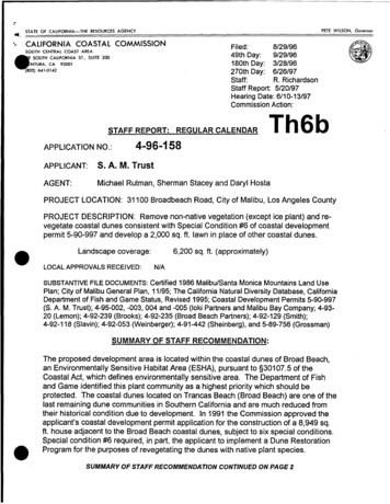
r.·"' ;;,ST AT E OF C;;A LIF,;;;OR;;N;,;;IA;;;;,;TH;;E RE;,;SO;;:;U;,;RC; ;ES;,;A;,;;G;;,EN;,;;CY PE TE W Il SO N , Go ve rnorCALIFORNIA COASTAL COMMISSIONFiled:8/29/9649th Day:9/29/96180th Day: 3/28/96270th Day: 6/26/97Staff:R. RichardsonStaff Report: 5/20/97Hearing Date: 6/10-13/97Commission Action:SOUTH CENTRAL COAST AREASOUTH CALIFORNIA ST., SUITE 200NTURA, CA 93001(805) 641.()142STAFF REPORT: REGULAR CALENDARAPPLICATION NO.:Th6b4-96-158APPLICANT:S. A. M. TrustAGENT:Michael Rutman, Sherman Stacey and Daryl HostaPROJECT LOCATION: 31100 Broadbeach Road, City of Malibu, Los Angeles CountyPROJECT DESCRIPTION: Remove non-native vegetation (except ice plant) andrevegetate coastal dunes consistent with Special Condition #6 of coastal developmentpermit 5-90-997 and develop a 2,000 sq. ft. lawn in place of other coastal dunes. 6,200 sq. ft. (approximately)Landscape coverage:LOCAL APPROVALS RECEIVED:N/ASUBSTANTIVE FILE DOCUMENTS: Certified 1986 Malibu/Santa Monica Mountains Land UsePlan; City of Malibu General Plan, 11/95; The California Natural Diversity Database, CaliforniaDepartment of Fish and Game Status, Revised 1995; Coastal Development Permits 5-90-997(S. A.M. Trust); 4-95-002, -003, 004 and -005 (loki Partners and Malibu Bay Company; 4-9320 (Lemon); 4-92-239 (Brooks); 4-92-235 (Broad Beach Partners); 4-92-129 (Smith);4-92-118 {Slavin); 4-92-053 (Weinberger); 4-91-442 (Sheinberg), and 5-89-756 (Grossman)SUMMARY OF STAFF RECOMMENDATION: The proposed development area is located within the coastal dunes of Broad Beach,an Environmentally Sensitive Habitat Area (ESHA), pursuant to §301 07.5 of theCoastal Act, which defines environmentally sensitive area. The Department of Fishand Game identified this plant community as a highest priority which should beprotected. The coastal dunes located on Trancas Beach (Broad Beach) are one of thelast remaining dune communities in Southern California and are much reduced fromtheir historical condition due to development In 1991 the Commission approved theapplicant's coastal development permit application for the construction of a 8,949 sq.ft. house adjacent to the Broad Beach coastal dunes, subject to six special conditions.Special condition #6 required, in part, the applicant to implement a Dune RestorationProgram for the purposes of revegetating the dunes with native plant species.SUMMARY OF STAFF RECOMMENDATION CONTINUED ON PAGE 2
.Coastal Development Permit 4-96-158Commission Meeting June 12, 1997Page2Special condition #1 required the applicant to revise the project plans to demonstratethat all development was set back behind a string line drawn from the corners of theadjacent structures and their decks. The applicant did not comply with the terms ofspecial condition #6 and instead recontoured a portion of the dunes and planted agrass lawn and also planted the other areas of the dunes with non-native vegetation.In addition, the applicant did not comply with the terms of special condition #1 in that alawn was planted seaward of the existing deck string line. Staff is recommending a two part decision. First, staff recommends approval of theportion of the project that involves restoration of the dunes subject to special condition#1. Second, staff is recommending denial of the portion of the lawn that exceeds thedeck string line because such development is inconsistent with §30240 of the CoastalAct.STAFF RECOMMENDATION:The staff recommends that the Commission adopt both of the following resolutions. Bydoing so, the Commission will approve the removal of all non-native plant species(including ice plant) and the restoration of the dunes with conditions, and will deny thedevelopment of the lawn that extends seaward of a string line between the corners ofthe adjacent decks:I. Approval with Conditions and DenialThe Commission hereby grants a permit for that portion of the proposed developmentinvolving the restoration of the coastal dunes including ice plant removal adjacent tothe applicant's single family residence, subject to the conditions below, on the groundsthat, as conditioned, those portions of the development that are approved will be inconformity with the provisions of Chapter 3 of the California Coastal Act of 1976, willnot prejudice the ability of the local government having jurisdiction over the area toprepare a Local Coastal Program conforming to the provisions of Chapter 3 of theCoastal Act, are located between the sea and the first public road nearest theshoreline and are in conformance with the public access and recreation policies ofChapter 3 of the Coastal Act, and will not have any significant adverse impacts on theenvironment within the meaning of the California Environmental Quality Act.The Commission hereby denies a permit for that portion of the proposed developmentinvolving the development of a grass lawn seaward of the deck stringJine on thecoastal dunes, which is located between the sea and the first public road nearest theshoreline, on the grounds that it would not be in conformity with the provisions ofChapter 3 of the California Coastal Act of 1976, including the public access policies;would not be in conformity with the provisions of the California Environmental QualityAct; and would prejudice the ability of the local government having jurisdiction over thearea to prepare a Local Coastal Program conforming to the provisions of the CoastalAct.
Coastal Development Permit 4-96-158Commission Meeting June 12, 1997Page3· .' II. Standard Conditions1. Notice of Receipt and Acknowledgment. The permit is not valid and developmentshall not commence until a copy of the permit, signed by the permittee or authorizedagent, acknowledging receipt of the permit and acceptance of the terms andconditions, is returned to the Commission office.2. Expiration. If development has not commenced, the permit will expire two yearsfrom the date on which the Commission voted on the application. Development shallbe pursued in a diligent manner and completed in a reasonable period of time.Application for extension of the permit must be made prior to the expiration date.3. Compliance. All development must occur in strict compliance with the proposal asset forth below. Any deviation from the approved plans must be reviewed andapproved by the staff and may require Commission approval.4. Interpretation. Any questions of intent or interpretation of any condition will beresolved by the Executive Director or the Commission. 5. Inspections. The Commission staff shall be allowed to inspect the site and thedevelopment during construction, subject to 24-hour advance notice.6. Assignment. The permit may be assigned to any qualified person, providedassignee files with the Commission an affidavit accepting all terms and conditions ofthe permit.7. Terms and Conditions Run with the land. These terms and conditions shall beperpetual, and it is the intention of the Commission and the permittee to bind all futureowners and possessors of the subject property to the terms and conditions.Ill. Special Conditions (for Pottion of Project Recommended for Approval)1. Revised Restoration and Monitoring Plan Prior to issuance of the coastal development permit, the applicant shall submit, for thereview and approval of the Executive Director, a revised Dune Restoration Programprepared by a qualified landscape Architect and reviewed by a qualified biologist,which shall restore and revegetate the coastal dunes with native plants endemic tocoastal dunes of this area. After the coastal development permit is issued, theapplicant shall implement the Dune Restoration Program approved by the ExecutiveDirector.Additionally, the restoration and revegetation program shall include: a) a provision forthe removal of all invasive and non-native plant species including ice plant. The
Coastal Development Permit 4-96-158Commission Meeting June 12, 1997Page4removal shall minimize any destabilization of the dunes and may include the usage ofgeofabrics; b) a maintenance and monitoring program, which includes three years ofmonitoring reports with photo-documentation and summaries of observations of therestoration work in spring and fall; c) a provision that if restoration program has beenin part, or in whole, been unsuccessful, the applicant shall submit a revised orsupplemental program to compensate for those portions of the original program whichwere not successful. The revised or supplemental restoration program shall beprocessed as an amendment to this permit. 2. Implementation and Completion of the Restoration PlanAll requirements, relative to the submittal of the Dune Restoration Plan containedwithin Special Condition #1 (a), (b) and (c) of this permit that are required to satisfiedas prerequisites to the issuance of this permit must be met within 60 days ofCommission action. Said plans shall be implemented within 30 days of the beginningof the 1997/98 raining season. Failure to comply with the requirements within the timeperiod specified, or within such additional time as may be granted by the ExecutiveDirector for good cause, will nullify this permit.IV. Findings and Declarations.The Commission hereby finds and declares:A. Protect Description and Background The applicant is proposing to remove non-native and invasive vegetation consisting ofpampas grass (cortaderia atacamensis), myoporum (myoporum laetum), leptosperumand osteospernum that have been planted on the dunes that are seaward of theexisting residence. After removing the vegetation, the applicant is proposing torevegetate a portion of the dunes with lemonade berry (rhus integrifolia), lance liveforever (duudleya lanceolata), and convolvulus solanella. In addition, the applicant isproposing to retain the non-native, invasive ice plant, which covers a portion of thedunes, and to develop a 2,000 sq. ft. lawn in place of coastal dunes, which requires recontouring of the dunes.Portions of the proposed project constitute what the Commission calls an "after-thefact" coastal development permit application. This means that the work has occurredon the site without the benefit of a coastal development permit. Additionally, portionsof the permit proposed are in non-compliance with the terms and conditions of coastaldevelopment permit 5-90-997. In the case of this development, the Commissionconsidered development on the subject site in 1991 under coastal development permit5-90-997 (S. A. M. Trust). Under this permit, the Commission approved the demolitionof an existing single family residence and the construction of a 8,949 sq. ft. singlefamily home with an attached garage and nanny's quarters with a septic system,swimming pool and 2,200 cu. yds. of fill on two lots which total 31,641 sq. ft. in size.
Coastal Development Permit 4-96-158Commission Meeting June 12, 1997PageSCoastal development permit 5-90-997 was approved subject to six special conditionswhich required the applicant to do the following: 1) submit revised plans that illustratedthat the development conformed to a building and deck stringline; 2) submit finaldevelopment plans that demonstrated the project's conformance with therecommendations contained in the applicant's geology plans; 3) record a deedrestriction that indicates that the applicant assumes the risk of developing in a locationthat could be subject to hazard; 4) record a deed restriction that any futuredevelopment on the site will require the applicant to obtain a permit; 5) submitevidence that the septic system expansion that is located seaward of the residenceand adjacent to the dunes is consistent with local government engineering standards;and, 6) submit and implement a dune restoration program for the purposes ofrevegetating the dunes with native dune plant species.B. Environmentally Sensitive Habitat Areas and Visual ResourcesThe Coastal Act defines an environmentally sensitive area in §301 07.5 stating that: environmentally sensitive area means any area in which plant or anima/life or theirhabitats are either rare or especially valuable because of their special nature or role inan ecosystem and which could be easily disturbed or degraded by human activitiesand developments.The proposed project site is located within the Trancas Beach (Broad Beach} coastaldunes, which are considered an environmentally sensitive area because this areasupports a flora and fauna restricted to coastal dunes and upper beaches. In addition,the Commission has found in certifying the Malibu Land Use Plan and in reviewingover a dozen permits for development on this beach that the dunes are anenvironmentally sensitive habitat area (ESHA). The Commission notes that theTrancas Beach dunes are the only extensive dunes within the 27 mile stretch of theMalibu Coastal Zone and that the Trancas dunes represent one of the last extensivedune fields existing in Southern California.The Coastal Act mandates that ESHAs be protected against habitat disruption.Furthermore, the Coastal Act requires that development adjacent to an ESHA be sitedand designed to prevent impacts that would degrade the ESHA value. Specifically,§30240 states:(a) Environmentally sensitive habitat areas shall be protected against any significantdisruption of habitat values and only uses dependent on such resources shall beallowed within such area. (b) Development in areas adjacent to environmentally sensitive habitat areas shalf besited and designed to prevent impacts which would significantly degrade such areasand shall be compatible with the continuance of such habitat areas.
Coastal Development Permit 4-96-1S8Commission Meeting June 12, 1997Page6In addition, the Coastal Act mandates that development be designed to minimize thealteration of natural landforms that are scenic to the coast. Specifically, §30251 of theCoastal Act states: The scenic and visual qualities of coastal areas shall be considered and protected as aresource of public importance. Permitted development shall be sited and designed toprotect views to and along the ocean and scenic coastal areas, to minimize the alterationof natural/and forms, to be visually compatible with the character surrounding areas,and, where feasible, to restore and enhance visual quality in visually degraded areas.New development in highly scenic areas such as those designated in the CaliforniaCoastline PreseNation and Recreation Plan prepared by the Department of Parks andRecreation and by local government shall be subordinate to the character of its setting.1. Coastal DunesCoastal dunes are a limited resource of statewide significance. Oceanfront dunes,such as those located on Broad Beach, provide unique scenic and habitat value. Ingeneral, coastal sand dunes are formed from wind transport. Coastal dunes that arenot vegetated are more susceptible to removal by tides or storms. In a developeddune field, the dunes closest to the beach will be rather flat and will be reformedregularly by wind and wave erosion. The foredunes protect the mid and back dunesfrom direct wind and wave attack. Typically the mid and back dune areas, similar tothose subject of this permit application, have a vegetative cover. Coastal dunesfunction as a system and not as independent units. Therefore changes in either thegeomorphology (contour) that result from grading or changes in vegetative cover thatresult from invasive plant species, have an effect on the entire system. For example,loss of dune area either close to the beach or in front of one residence can expose theback dune area landward or adjacent to the area to greater wind and wave erosion.Likewise, loss of native vegetation cover can result in isolated habitats throughout thedune field. The Trancas Beach area is developed almost completely with residential development.Approximately 100 homes exist landward of the dune field. The Commission staff hasbeen in conversations with members of the Trancas Beach Homeowners Associationover the past year regarding one of their key concerns: the diminishing dune field anddegradation of the native vegetation.Historically, Trancas Beach has been a wide beach area due to the accumulation of·sand along that stretch of the coast. The dune field has been reduced in width due, inpart, to urban and other development. Additionally, a portion of the dunes have beendisturbed as a result of individual footpaths across the dunes (from the homes to thebeach), introduction of non-native, invasive plant species (such as ice plant) andremoval of the sand dunes to improve property owner's individual views of the ocean.In spite of the disturbance that has resulted from development, the Broad Beach dunefields continue to maintain native vegetation found predominantly on dunes. However,due to the limited remaining distribution of the dune vegetation and the developmentpressure on areas which support the community, the southern foredunes found at
Coastal Development Permit 4-96-158Commission Meeting June 12, 1997Page 7Broad Beach are considered by the Department of Fish and Game as a highest priorityspecial plant community which should be protected (The California Natural DiversityDatabase, California Department of Fish and Game Status, Revised 1995).2. Past Commission ActionThe protection of coastal dunes has been the topic of Commission review bothstatewide and locally. In 1986, the Commission certified Malibu/Santa MonicaMountains Land Use Plan (LUP) with policies regarding ESHA protection and TrancasBeach dune preservation and enhancement. The policies contained in the LUP havebeen found consistent with the Coastal Act; and, therefore, may be looked to asguidance in reviewing coastal development permits. The LUP requires that the dunesbe protected and also suggests mitigation be provided for habitat impacts that resultfrom the residential development of the Broad Beach area. The Commission found incertifying the LUP that the restoration of damaged dune habitat is important inminimizing disruption of the this ESHA. The specific policies read as follow:P104 When feasible, the restoration of damage to habitat(s) shall be required asa condition of permit approval. P109 (Area-specific to Trancas Beach Southern Foredunes) For all newdevelopment, vegetation disturbance including recreation or foot traffic onvegetated dunes, should be minimized. When access through dunes isnecessary, well-defined foot paths shall be developed and used.Mitigation measures regarding coastal dune protection and enhancement have beenrequired by the Commission in the form of conditions of approval of coastaldevelopment permits. The mandate of Coastal Act §30240 has routinely been thebasis for such conditions. For example, in the City of Monterey, the Commissionapproved the development of a single family residence that was located within theSeaside dune system only with mitigation that included revising the project plans toreduce the size of the proposed house, implementation of a dune restoration plan andpayment of a fee to the City of Monterey for purposes of providing on/off site dunerestoration. Likewise, conditions of approval have been placed on coastal development permitapprovals in the Malibu area. As stated previously, Trancas Beach is the only areaalong the Malibu coastline that contains an extensive dune field. Since thecertification of the Malibu/Santa Monica Mountains LUP, more than thirteen coastaldevelopment permits have been approved for development on Trancas Beach (seepage 1, Substantive File Documents). In all of these permits the proposeddevelopment encroached upon the ESHA. The Commission approved thesedevelopments as consistent with §30240 of the Coastal Act only as conditioned torequire the applicant to restore and enhance the vegetative cover of the dune fields(emphasis added).
Coastal Development Permit 4-96-158Commission Meeting June 12. 1997Page8For example, under coastal development permit 4-93-020 (Lemmon), the Commissionapproved revegetation and enhancement of the Trancas dunes that had beendisturbed by unpermitted development, which included landscaping with non-nativevegetation. The permit was approved with special conditions that required theimplementation of the proposed revegetation of the coastal dunes and the removal ofall non-native vegetation. In addition, coastal development permits 4-95-002 and 495-005 (loki Partners and Malibu Bay Co.) were each approved by the Commission forthe demolition of existing single family residences and the construction of new homes.Both of the permits involved the encroachment of development onto the dunes. One ofthe special conditions of approvals included requiring the applicant to submit andimplement a Dune Restoration Program. Similarly, under coastal development permit4-92-053 (Weinberger), the Commission approved a remodel and 1,050 sq. ft. additionto an existing single family residence, the expansion of a leachfield and septic systemwith a rock blanket seaward of the residential structure. Since the expandedleachfields encroached into the dune field, one of the special conditions of approvalsincluded requiring the applicant to submit and implement a Dune Restoration Program.Additionally, coastal development permits 4-95-004 and 4-95-005 (loki Partners andMalibu Bay Co.), 4-92-139 (Smith), 4-92-239 (Brooks), 4-92-235 (Broad BeachPartners); 4-92-129 (Smith), 4-92-118 (Slavin), 4-91-442 (Sheinberg), and 5-89-756(Grossman) were all approved by the Commission for development located in TrancasBeach with a very similar Dune Restoration Program special condition.3. Chapter 3 Analysis of Permit In comparing the proposed permit application against the Coastal Act, the Commissionmust determine whether the proposal is consistent with the Chapter 3 policies of theCoastal Act. §30240(a) requires that ESHAs be protected against any significantdisruption of habitat values and that only resource dependent uses be allowed withinsuch an area. In addition, §30240(b) mandates that development in areas adjacent toenvironmentally sensitive habitat areas be sited and designed to prevent impactswhich would significantly degrade such areas and be compatible with the continuanceof such habitat areas. Furthermore, §30251 requires that the scenic and visualqualities of coastal areas be considered as a resource of public importance. §30251charges the Commission with requiring that new development be visually compatiblewith the character of the surrounding area and minimizes the alteration of natural landforms.The proposed project involves landscaping of the coastal dunes which are locatedseaward of the applicant's single family residence. As described in the projectdescription above, there are two competing landscaping schemes being proposed.First, the applicant is proposing to remove some of the non-native vegetation {pampasgrass (cortaderia atacamensis), myoporum (myoporum laetum), leptosperum andosteospernum} and revegetate these areas of the dunes with native plants {lemonadeberry (rhus integrifolia), lance live forever (duudleya lanceolata), and convolvulussolanella}. Second, the applicant is proposing to plant a 2,000 sq. ft. lawn area, whichrequires minor recontouring of the back dune area and to retain the existing ice plantvegetation that covers a portion of the dunes. The lawn area exceeds a string line
Coastal Development Permit 4-96-158Commission Meeting June 12, 1997Page9drawn between the corners of the adjacent decks. As noted previously, the applicanthas already recontoured the dunes and planted the lawn. This work is inconsistentwith the previous conditions required in the prior permit (5-90-997).In order to thoroughly analyze the proposal against the above cited Chapter 3 policiesof the Coastal Act, the two components will considered individuaHy. The restorationproposed by the applicant is illustrated on a site plan and identifies the use of nativeplant species in place of the vegetation that will be removed. Even though theproposed vegetation is native, it is not characteristic of the coastal dune native plants.As identified in the City of Malibu General Plan, vegetation characteristic of thesouthern foredunes that represent the limited remaining distribution of the dune fieldinclude the following: sand-verbena (Abronia §QQ.); silver beachweed (Ambrosiachamissonis); horned sea-rocket (Cakile maritime); beach morning-glory (Calystegiasoldanella); and, beach evening primrose (Camissonia cheiranthifolia). As stated above, the California Department of Fish and Game has identified the dunesas the highest priority special plant community which should be protected. Ascontained in the Holland Terrestrial Natural Communities of California Reportprepared by the Department of Fish and Game in 1986, one of the seven majorcategories of terrestrial vegetation communities identified in the Malibu Coastal Zoneis the coastal dune scrub. The other six communities identified include: 1) Chaparrals;2) Coastal Sage Scrub; 3) Oak Woodland and Forest; 4) Riparian Scrubs, Woodlandsand Forest; 5) Freshwater Marsh; and, 6) Coastal Brackish Marsh. The City of MalibuGeneral Plan also cites the report and states that the "These major vegetation typeshave been further classified as discrete plant communities that generally sharecharacteristic species and have similar physiographic site characteristics." {page 3-21)The retention of non-native invasive ice plant in concert with restoration raises aninherent contradiction. By definition, invasive plant species out-compete and kill thenative plant communities for water and nutrients often leading to their death. As such,any restoration proposal that does not include the removal of invasive species isunlikely to be fully successful. In order to ensure that the proposed restoration plan isperformed in a manner that protects the ESHA against any significant disruption,special condition #1 has been drafted. As set forth in the condition, the applicant shallsubmit revised Dune Restoration Program prepared by a qualified LandscapeArchitect and reviewed by a qualified biologist, in order to ensure that the dunes arerestored and revegetated with native plants endemic to coastal dunes of this area.Specifically, the restoration and revegetation program shall include:a) a provision for the removal of all invasive and non-native plant species includingice plant. The removal shall minimize any destabilization of the dunes and mayinclude the usage of geofabrics; b) a maintenance and monitoring program, which includes three years ofmonitoring reports with photo-documentation and summaries of observations ofthe restoration work in spring and fall; and,
Coastal Development Permit 4-96-158Commission Meeting June 12, 1997Page10c) a provision that if restoration program has been in part, or in whole, beenunsuccessful, the applicant shall submit a revised or supplemental program tocompensate for those portions of the original program which were not successful. Additionally, special condition #2 has been required to ensure that the submittal of theDune Restoration Plan as contained within special condition #1 (a) of the permitoccurs within 60 days of Commission action. Furthermore, the condition requires thatthe Dune Restoration Plan be implemented within 30 days of the beginning of the1997/98 raining season and that the restoration work be monitored for success asprovided for in special condition #1 (b) and (c). Only as conditioned, is the restorationcomponent of the proposed project consistent with §30240 of the Coastal Act.The second component of the proposed project involves placing a 2,000 sq. ft. lawnarea, which is seaward of the deck area of the residence. In order to develop the lawnsome minor land form alteration of the dune field must occur. As stated above, sanddune fields function as one system. Trancas Beach is currently developed withapproximately 100 homes. The majority of these homes are landward of coastaldunes. However, the vast majority of the Trancas dunes are in private ownership byover 100 different property owners. Therefore, any maintenance or enhancement ofthe dune field has been subject to proliferated efforts. Likewise, any disturbance ofthe dunes as a result of development has also occurred on a lot by lot basis.The benefits of the dunes from a coastal resource and from a visually aestheticstandpoint have been recognized by the Commission in the review and approval ofdevelopment within the Northern, Central, and some parts of the Southern Coast.Another benefit realized by the dune fields is their ability to protect developmentlandward of the dunes from wave erosion. The dune fields function as a naturalshoreline protective device. Further, the dunes provide a visual buffer and screeningbetween the public's use along the beach and the residential development that sitedlandward of the dune fields. Trancas Beach which is over 5,000 feet in length extendsfrom Lechuza Point to the North to Zuma Creek to the south. The beach comprisesone of the southern most dune fields to support endemic coastal dune habitat with theexception of El Segundo, Los Angeles County. The City of Malibu contains one of the most extensive natural coastlines in LosAngeles County. As stated in the Malibu General Plan, "Marine resources along theMalibu coast include kelp beds, tide pools, marine fisheries, offshore reefs, sandybeaches, rocky haul outs, coastal dunes and isolated wetlands." In an effort to protectthese resources the State Water Resources Control Board (SWRCB) designated theentire coastline from Point Magu to Latigo Point as an Area of Special BiologicalSignificance (ASBS). The SWRCB.defines an ASBS as an area "requiring protectionof species or biological communities."Incremental development within these dunes will result in the complete degradation ofthe dune ESHA. As stated previously, Trancas Beach is presently developed withapproximately 100 homes. The beach front lots on Trancas Beach extend from BroadBeach
PROJECT LOCATION: 31100 Broadbeach Road, City of Malibu, Los Angeles County PROJECT DESCRIPTION: Remove non-native vegetation (except ice plant) andre vegetate coastal dunes consistent with Special Condition #6 of coastal development permit 5-90-997 and deve