Transcription
Supplemental Historic Resources Survey ReportIndustrial Zone Properties in thePalms–Mar Vista–Del Rey CommunityPlan AreaPrepared for:City of Los AngelesDepartment of City PlanningOffice of Historic ResourcesPrepared by:December 2015
Table of ContentsProject OverviewProject TeamSurvey AreaSummary of FindingsSummary of Property TypesSummary of Contexts and ThemesFor Further ReadingSurveyLAPalms-Mar Vista-Del Rey Community Plan Area – Supplemental11166612
Project OverviewThis supplemental historic resources survey report (“Supplemental Survey Report”)summarizes additional field work conducted for SurveyLA in the industrially-zonedareas of the Palms-Mar Vista-Del Rey Community Plan Area (CPA). 1 This survey reportis to be used in conjunction with the main survey report and associated appendices forthis CPA, published in July 2012. 2 All survey work was conducted according toSurveyLA methodology as discussed in the Palms-Mar Vista-Del Rey main surveyreport.Project TeamAdditional survey work in the Palms-Mar Vista-Del Rey CPA was conducted by HistoricResources Group. Personnel included Kari Michele Fowler, Senior Preservation Planner;Christine Lazzaretto, Principal; Heather Goers, Architectural Historian; and RobbyAranguren, Planning Associate. Additional assistance was provided by intern ScottWatson. Kari Fowler served as the project manager.Survey AreaDescription of Industrial Zone AreasThe survey area (“Survey Area”) includes approximate 512 industrially-zoned parcelsin the Palms-Mar Vista-Del Rey CPA. Of these, approximately 407 parcels were surveyedby SurveyLA. SurveyLA generally does not include properties constructed after 1980, orresources that have been designated under Federal, state, or local programs. The mapbelow illustrates the boundaries of the CPA and the location of industrially-zonedparcels.The Survey Area includes parcels within the CPA that were zoned industrial at the timeof the survey. It includes industrial property types, but also may include other uses andassociated property types such as residential, commercial, and institutional.Industrial properties are concentrated primarily in the southwest corner of the CPA,with smaller concentrations and individual properties found in the northwest andWhen this CPA was originally surveyed for SurveyLA, the Industrial Development context for theCitywide Historic Context Statement had not been developed. Therefore, industrially-zoned parcelscould not be surveyed at that time. The context has since been completed. For this reason, survey teamshave returned to this CPA to survey industrial parcels.2 The main survey report and all appendices for the Palms-Mar Vista-Del Rey CPA can be found -and-reports.1SurveyLAPalms-Mar Vista-Del Rey Community Plan Area – Supplemental1
Survey Area Map with Industrially-Zoned Parcels.SurveyLAPalms-Mar Vista-Del Rey Community Plan Area – Supplemental2
northeast. With the exception of several small concentrations of properties occurringadjacent to or near railway lines, most industrial properties in the CPA are locatedalong major commercial corridors and freeways such as Jefferson Boulevard, CulverBoulevard, the Marina (90) Freeway, and the San Diego (405) Freeway.Industrial Zone Areas Development HistoryIndustrial development within the Palms-Mar Vista-Del Rey CPA was largely driven byregional shifts in the economy in the first decades of the 20th century. Aviation was agrowing industry in Los Angeles as early as the 1910s, as agricultural lands on the city’sWestside gave way first to landing strips and small airports, and later to municipalairports and aircraft production plants. By 1929, Los Angeles County had 55 airportsand landing fields, 27 accredited aviation schools, and several major airplane factories,many of which were concentrated on the Westside. 3 Most notable among these wereClover Field and Mines Field. Clover Field was the home of the Douglas AircraftCompany from the early 1920s through the 1950s, and would later become the SantaMonica Airport. 4 In 1930, Mines Field opened as the City of Los Angeles’ municipalairport, which would later become Los Angeles International Airport (LAX). 5By the 1930s, the aviation industry was well-established in the area, which in turnspurred the development of various aviation-related industrial support services. Whilemost of these early ventures were short-lived and did not operate past the 1930s, LosAngeles had established itself and the center of West Coast aviation manufacturing andtravel.Other industries also expanded into the area during the 1920s and 1930s. With thediscovery of oil in nearby Baldwin Hills in 1924, then in Playa Del Rey and Venice in1932, the petroleum industry became instrumental in the development of the CPA. Overtime, additional manufacturing plants which processed raw materials such as sheetmetal, lumber, and plastics opened in the area to serve the needs of the aviation,petroleum, and other industries.The synergistic relationship between the manufacturing facilities and the nearbyairports – the Los Angeles International Airport in particular – allowed the aviationindustry to flourish throughout the 1940s and 1950s. The proliferation of productionplants located so close to a central distribution hub like LAX allowed Los Angeles tobecome the nexus of the nation’s wartime aircraft manufacturing as well as researchand development. In 1940, Howard Hughes established his airport and aircraft plant inthe Ballona wetlands of present-day Playa Del Rey. In 1945, the U.S. Army Air Forcescontracted with Douglas Aircraft Company to create Project RAND, combining militaryplanning with technology research and development. RAND was soon incorporated as aKevin Starr, Embattled Dreams (New York: Oxford University Press, 2002), 133.The Santa Monica Airport is located north of the CPA.5The Los Angeles International Airport (LAX) is located south, and outside of, the CPA. LAX is its ownCommunity Plan Area and not being surveyed for SurveyLA.34SurveyLAPalms-Mar Vista-Del Rey Community Plan Area – Supplemental3
separate nonprofit but would remain headquartered in Santa Monica, eventuallygrowing to become an established presence in the area.One particular example of development which emerged during this period is theQuonset hut, of which there are several extant examples in the industrial areas of theMar Vista and Del Rey. The origins of the Quonset hut can be traced across the Atlanticand back to World War I, when the British Army began to experiment withmanufacturing prefabricated structures for use during wartime campaigns. In 1916,Major Peter Norman Nissen of the Corps of Royal Engineers developed plans for a semicylindrical hut constructed of corrugated steel sheets placed atop arched steel framing.The design for the hut proved particularly appealing due to its portability, ease andexpediency of assembly, and economy of building materials.In 1941, as the United States contemplated its entry into World War II, military officialsrecognized that the Navy might soon face the problem of transporting and housing largenumbers of troops, as well as storing large quantities of materials and resources. Thus,the Navy engaged the architectural firm of George A. Fuller & Company to design a hutfor American military use. Military officials were already familiar with Fuller &Company, as they had been contracted to construct a new Navy base at Quonset Point,Rhode Island, from which the new structure would get its name. The Navy providedonly two specifications for the project: “the new huts should be arch shaped, forstrength and deflection of shell fragments, and able to be quickly and simplyassembled.” 6Over the course of World War II, three primary versions of the hut were produced: theT-Rib Quonset, the Quonset Redesign, and the Stran-Steel Quonset. The hut wasconceived as a standard building unit – inexpensive, easy to ship, easy to erect, andversatile in accommodation – ideal for use at remote new installations where buildingmaterials and skilled workers were not available and shipping was difficult. 7 The hutwas designed to serve 86 official uses, 8 but in practice was adapted to virtually everytype of military program. Following the war, the huts were sold off by the U.S.Government and adapted for a wide variety of peacetime uses, serving as churches,supermarkets, barns, retail spaces, restaurants, garages, and industrial factories. 9 Manyhuts were purchased, either by municipal authorities or by returning GIs themselves,for use as housing for returning servicemen and their families. Concurrently, a numberof private contractors recognized that the market for Quonset hut-type constructioncould extend beyond military utility, and they began to develop their own versions of“Chapter 1: How the Hut Came to Be,” Quonset: Metal Living for a Modern Age,http://quonsethuts.org/book/chapter1.htm (accessed March 2015).7 “Camp Endicott, Davisville Construction Battalion Center,” National Register of Historic PlacesNomination Form, available athttp://www.preservation.ri.gov/pdfs zips downloads/national pdfs/north kingstown/noki campendicott-hd.pdf (accessed March 2015).8 “The Huts,” Quonset: Metal Living for a Modern Age, http://quonsethuts.org/huts/index.htm (accessedMarch 2015).9 Ibid.6SurveyLAPalms-Mar Vista-Del Rey Community Plan Area – Supplemental4
the Quonset hut to market to “the Army or anyone else who would buy them.” 10 Today,Quonset huts of various types and sizes can be found through Los Angeles, most often inindustrial areas. Typical uses include light manufacturing, repair facilities, and storage.By the 1950s, industrial operations in the CPA had expanded to include a broad anddisparate range of uses, from furniture manufacturing and machine shops, to tourism,photography studios, a candy factory, a lumber company, a lime warehouse, and afoundry. However, many of these use are no longer present today. Significant postWorld War II expansion of the aircraft manufacturing industry for both commercialtravel and the development of aircraft and weaponry for Cold War-era intercontinentalwarfare fueled economic growth and industrial expansion. One such example is aconcentration of industrial properties along Panama Street in Del Rey. Constructedbetween 1955 and 1960, these buildings have been occupied by various industrialtenants over time, some of which have been associated with the aerospace and defenseindustries. Uses have included aircraft lighting, aerospace micro-electronics, electronicequipment assembly, electronics manufacturing, and various other factory andwarehouse uses. One long-time tenant is Teledyne Systems Corporation, an aerospaceinformation and communication technology company, which first located on this site in1965.The evolution of development along Panama Street reflects the changing character ofindustrial resources in the CPA. Many of the earliest airports dating from the 1920swere demolished prior to World War II to make way for residential development. Overtime, many industrial parcels have been demolished or converted to other uses,including residential, commercial, and manufacturing functions. Only a few pockets ofparcels zoned for industrial use remain today.10Ibid.SurveyLAPalms-Mar Vista-Del Rey Community Plan Area – Supplemental5
Summary of FindingsThe following discussion of Contexts, Themes and Property Types relates to resourceson industrially-zoned parcels identified and recorded as eligible for designation.Summary of Property TypesThe Palms-Mar Vista-Del Rey CPA contains a limited number of extant industrialproperty types. Only a handful of these were documented and evaluated as historically,culturally, or architecturally significant, including two 1930s industrial buildings inPalms, one late-1950s office and light industrial park in Del Rey, as well as a number ofWorld War II-era Quonset huts. Additionally, a small number of residential propertiessituated on an industrially-zoned parcel were also evaluated.Summary of Contexts and ThemesDue to the limited number of industrially-zoned parcels in the survey area, only two ofthe themes developed for the Industrial Context of the SurveyLA Citywide HistoricContext Statement are represented in the Palms-Mar Vista-Del Rey CPA. Additionally, aResidential Development theme and an Engineering theme are also represented.For a list of all resources identified in the Survey Area, see the Palms-Mar Vista-Del ReyCommunity Plan Area Industrial Zone Properties Supplemental Appendices -and-reports.SurveyLAPalms-Mar Vista-Del Rey Community Plan Area – Supplemental6
Context: Industrial Development, 1850-1980Theme: Early Industrial Development, 1880-1945This theme was used to evaluate two examples of early industrial development inPalms; few examples remain from this period. The property at 9200 ExpositionBoulevard is a rare remaining example of a brick industrial building from the early1930s. The property at 3380 S. Robertson Boulevard, from the late 1930s, wasoriginally constructed as an ironworks building, now occupied by a bakery. Bothexamples display influences of the Streamline Moderne style.Address: 9200 Exposition BoulevardDate: 1932Address: 9200 Exposition BoulevardDate: 1932Address: 3380 S. Robertson BoulevardDate: 1938Address: 3380 S. Robertson BoulevardDate: 1938SurveyLAPalms-Mar Vista-Del Rey Community Plan Area – Supplemental7
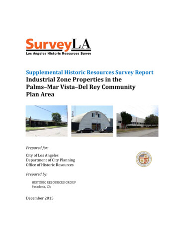
Context: Industrial Development, 1850-1980Theme: Industrial Design & Engineering, 1887-1965This theme was used to evaluate a rare example of a late-1950s office and lightindustrial park in Del Rey. The Panama Street Industrial Historic District comprises asingle triangular-shaped industrial site. The site contains seven one-story lightindustrial buildings, constructed between 1955 and 1960, and several surface parkingareas. The buildings have been occupied by various tenants over time, some of whichhave been associated with the aerospace and defense industries. Uses have includedaircraft lighting, aerospace micro-electronics, electronic equipment assembly,electronics manufacturing, and various other factory and warehouse uses. One longtime tenant is Teledyne Systems Corporation, an aerospace information andcommunication technology company, which first located on this site in 1965. Today,Teledyne occupies at least two of the buildings on the block; three buildings appear tobe vacant.Address: 12820 Panama StreetDate: 1955Address: 12820 Panama StreetDate: 1955Address: 12870 Panama StreetDate: 1955Address: 12870 Panama StreetDate: 1955SurveyLAPalms-Mar Vista-Del Rey Community Plan Area – Supplemental8
Address: 12910 Panama StreetDate: 1957Address: 12910 Panama StreetDate: 1957Address: 12930 Panama StreetDate: 1956Address: 12930 Panama StreetDate: 1956Address: 12964 Panama StreetDate: 1957Address: 12964 Panama StreetDate: 1957SurveyLAPalms-Mar Vista-Del Rey Community Plan Area – Supplemental9
Context: Architecture and Engineering, 1850-1980Sub-context, Engineering, 1900-1980Theme: Technological Developments in Construction, 1900-1980Sub-Context: The Quonset Hut, 1941-1965This theme was used to evaluate intact examples of Quonset huts. Quonset huts aresignificant as representative of an important building type and method of constructiondeveloped during World War II. The Quonset hut is notable for its simple construction,distinctive shape, use of prefabricated materials, and flexible interior plan. Intactexamples represent the design and development of a low-cost and highly-versatilestructure by the U.S. Navy for military use during World War II, and its adaptive reusefor housing and other uses during the postwar years. Significant examples retain theessential physical features from the type, including its semi-cylindrical shape andcorrugated metal cladding. An important symbol of mid-century utilitarian design andconstruction, the Quonset hut is a rapidly disappearing building type.Address: 11844 S. Jefferson BoulevardDate: 1946 (est.)Address: 3906 S. Grand View BoulevardDate: (Unknown)SurveyLAPalms-Mar Vista-Del Rey Community Plan Area – Supplemental10
Context: Residential Development and Suburbanization, 1850-1980Theme: Early Residential Development, 1880-1930Sub-Theme: Early Single-Family Residential Development, 1880-1930This theme was used to evaluate rare remaining examples of early residentialdevelopment in industrial areas in Palms and Mar Vista. Identified examples are singlefamily residences dating from the late teens and early 1920s.Address: 3900 S. Grand View Bl.Date: 1922Address: 3340 S. Robertson Bl.Date: 1919SurveyLAPalms-Mar Vista-Del Rey Community Plan Area – Supplemental11
For Further ReadingBottles, Scott L. Los Angeles and the Automobile: The Making of a Modern City. Berkeley:University of California Press, 1987.Chase, John. Glitter, Stucco and Dumpster Diving: Reflections on Building Production in theVernacular City. New York: Verso, 2000.Garrigues, George. Los Angeles’s The Palms Neighborhood. Images of America series. Charleston,SC: Arcadia Publishing, 2009.Hise, Greg. Magnetic Los Angeles: Planning the Twentieth-Century Metropolis. Baltimore: TheJohns Hopkins University Press, 1997.Mar Vista Historical Society. http://www.marvistahistoricalsociety.net/ (accessed October2015).Parker, Dana T. Building Victory: Aircraft Manufacturing in the Los Angeles Area in World War II.Cypress, CA: 2013.SurveyLAPalms-Mar Vista-Del Rey Community Plan Area – Supplemental12
the Quonset hut to market to “the Army or anyone else who would buy them.” 10. Today, Quonset huts of various types and sizes can be found through Los Angeles, most often in industrial areas. Typical uses include light manufacturing, repair facilities, and storage. By the 1950s, indus