Transcription
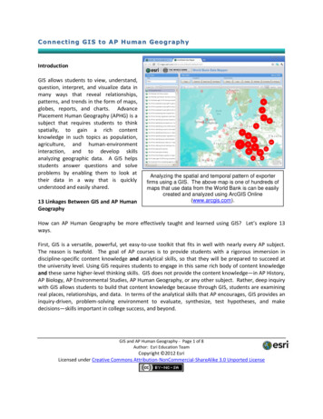
Connecting GIS to AP Human GeographyIntroductionGIS allows students to view, understand,question, interpret, and visualize data inmany ways that reveal relationships,patterns, and trends in the form of maps,globes, reports, and charts. AdvancePlacement Human Geography (APHG) is asubject that requires students to thinkspatially, to gain a rich contentknowledge in such topics as population,agriculture, and human-environmentinteraction, and to develop skillsanalyzing geographic data. A GIS helpsstudents answer questions and solveproblems by enabling them to look attheir data in a way that is quicklyunderstood and easily shared.13 Linkages Between GIS and AP HumanGeographyAnalyzing the spatial and temporal pattern of exporterfirms using a GIS. The above map is one of hundreds ofmaps that use data from the World Bank is can be easilycreated and analyzed using ArcGIS Online(www.arcgis.com).How can AP Human Geography be more effectively taught and learned using GIS? Let’s explore 13ways.First, GIS is a versatile, powerful, yet easy-to-use toolkit that fits in well with nearly every AP subject.The reason is twofold. The goal of AP courses is to provide students with a rigorous immersion indiscipline-specific content knowledge and analytical skills, so that they will be prepared to succeed atthe university level. Using GIS requires students to engage in this same rich body of content knowledgeand these same higher-level thinking skills. GIS does not provide the content knowledge—in AP History,AP Biology, AP Environmental Studies, AP Human Geography, or any other subject. Rather, deep inquirywith GIS allows students to build that content knowledge because through GIS, students are examiningreal places, relationships, and data. In terms of the analytical skills that AP encourages, GIS provides aninquiry-driven, problem-solving environment to evaluate, synthesize, test hypotheses, and makedecisions—skills important in college success, and beyond.GIS and AP Human Geography - Page 1 of 8Author: Esri Education TeamCopyright 2012 EsriLicensed under Creative Commons Attribution-NonCommercial-ShareAlike 3.0 Unported License
Asking questions is the first part of geographic inquiry: It forms the basis for knowing what types ofsocial data to collect, what data to analyze, and what decisions to make. The GIS does not ask thequestions. Rather, it is the student that has a firm foundation in understanding such APHG topics asenergy production and cultural patterns, who asks the questions. Systems such as watersheds andbiomes have shaped human behavior and interaction, and conversely, humans have profoundly affectedthese natural systems. Understanding these interactions is fundamental to asking questions and solvingproblems with GIS.Second, using GIS is aligned with the purpose of the AP Human Geography course. The purpose of theAP Human Geography course (The College Board 2011) is to “introduce students to the systematic studyof patterns and processes that have shaped human understanding, use, and alteration of the Earth’ssurface.” GIS was created to examine patterns and processes in a systematic way. In APHG, “studentsemploy spatial concepts and landscape analysis to examine human social organization and itsenvironmental consequences.” Students can use GIS to examine the temporal and spatial componentsof concepts from migration to urbanization, from land use change to the organization of cities. In APHG,students “also learn about the methods and tools geographers use in their science and practice.” A keyadvantage of using GIS is that it is a professional tool created in part by professional geographers andused by professional geographers, wildlife biologists, city planners, epidemiologists, and by those inhundreds of other job descriptions on a daily basis to solve problems.Third, using GIS adheres to each of the five major goals of APHG. The first of these is “to use and thinkabout maps and spatial data.” In the 21st Century workplace, maps and spatial data are used on a dailybasis, but they are not used as paper map sheets in a drawer or those that can be pulled down from aroller on a wall. Today’s maps can be created in seconds, modified, saved, shared, and applied in manydifferent ways, in many different locations, and at many different scales. These are digital maps andimages found in a GIS environment. Students using GIS cannot help but think about spatial data,because each map in a GIS is tied to a geographic database. That database can be queried, sorted, andmodified as the problem dictates.The second goal is “to understand and interpret the implications of associations among phenomena.”GIS was created to enable people to understand associations, such as between political systems andresulting land use, between urbanization and impervious surface, water quality, and runoff, and manyother topics core to APHG. The third goal is “to recognize and interpret at different scales therelationships among patterns and processes.” Paper maps limit the user to a specific scale, specificsymbols, and specific themes, but in a GIS, all of these may be modified, so that patterns can bedetected. Considerations of scale—from the accuracy of spatial data to the proper scale suitable tosolve a problem—are central to being effective with GIS. Using a GIS, students can determine howevents and processes at different scales influence one another.The fourth goal is to “define regions and evaluate the regionalization process.” Students using GIS candraw boundaries around regions of specific ethnicities, histories, or environments, assess whether theseGIS and AP Human Geography - Page 2 of 8Author: Esri Education TeamCopyright 2012 EsriLicensed under Creative Commons Attribution-NonCommercial-ShareAlike 3.0 Unported License
areas qualify as a “region” based on APHG definitions, modify them, and re-evaluate. The fifth goal is to“characterize and analyze changing interconnections among place.” GIS allows neighborhoods, cities,regions, and countries to be examined over time, through asking questions spatially or by attribute, orto enable time animations.The fourth connection between APHG and GIS is rigor. GIS is a professional set of quantitative analyticaltools. Students using GIS engage the discipline of geography in a rigorous way, from building models totesting whether a specific map projection is more suitable for a certain problem, to symbolizingdemographic maps as quantile versus equal interval. In short, students using GIS are developing andapplying skills, abilities, and content knowledge for college, which is the fundamental goal of AP.Fifth, the fact that each school develops its own curriculum for APHG also makes GIS an appealingtechnology to use. GIS is not a one-size fits all type of technology. It can be used in many ways—onlineor as desktop computer software, with step-by-step or open ended lessons, grappling with local issuesor global problems, or analyzing watersheds or suburbanization. GIS can also ingest information from awide variety of sources—anything from student-collected data on businesses in their local community,to population data from the US Census Bureau, to economic data from the World Bank. GIS can outputinformation as maps, graphs, tables, movies, animations, in map-based presentations, and in standardreports.Sixth, GIS can be effectively used to study each of the seven main topics in APHG. The first of these,“Geography: Its nature and perspectives” can be effectively taught with GIS, as we have seen becauseof the importance that geography and GIS place on spatial organization. These include geographicconcepts such as location, space, place, scale, pattern, regionalization, and globalization. Settlementpatterns, especially urbanization, can be studied by examining satellite images over time or contrastingzoning in different cities. The first topic includes that “students learn how to use and interpret maps,apply mathematical formulas, models, and qualitative data to geographical concepts,” which, as wehave seen, is enabled by GIS. GIS allows students to more rapidly move from the data gathering stage tothe data analysis stage. Through spatial analysis and making decisions in a GIS environment, studentsbecome keenly aware of the “relevance of academic geography to everyday life and decision making.”The second APHG topic, “Population,” can also be taught effectively with GIS. Through analyzing dataspatially with maps and databases, students make sense of cultural, political, economic, and urbansystems. They can examine trade balances around the world or median income by neighborhood intheir own city. They can understand fertility, mortality, and migration by, for example, making mapsand contrasting median age and fertility rates around the world. GIS can also enhance teaching andlearning about the third APHG topic, “Cultural patterns and processes” through examining the conceptof culture. For example, they can assess the spatial and place dimensions of cultural groups as definedby language, religion, race, ethnicity, and gender, in the present as well as in the past. Through themaps they make and the patterns that they uncover, they will understand diffusion across time andGIS and AP Human Geography - Page 3 of 8Author: Esri Education TeamCopyright 2012 EsriLicensed under Creative Commons Attribution-NonCommercial-ShareAlike 3.0 Unported License
space. Through examining land use patterns or tourism impacts, they will understand the way cultureshapes human-environmental relationships.The fourth APHG topic, “Political organization of space” can also be taught effectively with GIS.Students can examine boundaries and problems that so easily cross them, such as water quality andurban growth. The fifth APHG topic, “Agriculture and rural land use” can also be analyzed spatiallywithin a GIS framework. Students can use GIS to help them understand how agricultural regionsfunction, and the impact of agricultural change on the quality of life and the environment. For example,they can examine the distribution of Earth’s major crop production regions. They can also examine landsurvey systems such as metes-and-bounds, the public land survey system in the USA, and the Frenchlong lot system using maps and satellite images. They can assess how these land survey systems bothimpact and reflect environmental conditions and cultural values. Using GIS can address the sixth APHGtopic, “Industrialization and economic development” in similar ways, because economic activity has aspatial character influenced by the interaction of such factors as natural resources, culture, politics, andhistory. Economic inequality can be examined at an individual community level or on a global level.Finally, GIS can help students understand the seventh APHG topic, “Cities and urban land use.” Studentsusing GIS can study systems of cities, discover where cities are located, and analyze why they arethere—both their site and situation, and also from the global perspective. The current and historicaldistribution of cities, for example, can be studied by examining the 10 most populous cities over the past2,500 years in a GIS. The economic and cultural functions of cities, reasons for their differential growth,and the types of transportation and communication linkages can all be studied with maps, images, anddatabases showing land use, transportation routes, zoning, and demography. Comparing the form,structure, and landscapes of cities pastand present can be accomplished withhistorical and current maps in a GIS, in aqualitative and quantitative way.The seventh link between GIS and APHGis that AP courses emphasize systemsthinking. The “S” in GIS stands for“system”, so systems thinking isembedded in spatial analysis.Themapped layers may or may not berelated in theme, scale, proximity, andprocess to each other. For example, soilin an area is influenced by the bedrockgeology, local weathering, and regionalclimate, and in turn influences the localland use, vegetation, and animalssupported, influencing the ecoregion andGIS and AP Human Geography - Page 4 of 8Author: Esri Education TeamCopyright 2012 EsriLicensed under Creative Commons Attribution-NonCommercial-ShareAlike 3.0 Unported License
the threats to that ecoregion. By being able to ask questions of multiple data sets, students can analyzeconcepts and processes in a holistic fashion. Let’s consider the impact of cities on watersheds as oneexample.Using ArcGIS Online, students can examine current weather, compare rainfall to current streamflow,consider the drainage area of the watershed, and assess how the impervious surface of cities impactstreamflow.Eighth, GIS is well-connected to the critical thinking emphasis of APHG because students using GIS needto continually question the accuracy, validity, source, purpose, and appropriateness of the data they areusing. Maps, like other data, are useful, but contain inaccuracies, distortions, and missing data. Errorneeds to be understood and managed. Finally, GIS is not a closed system, but rather, an open one thatcan be customized and shared.Ninth, each of the key issues of APHG, from the impact of cities on the environment, to migration, toland use decisions, and more, occurs somewhere, and typically occurs in multiple locations and at avariety of scales. Each arose somewhere, diffused somehow, and each changes over space and time.Each affects the ways that other phenomena interact. The geographic perspective is thereforeimportant in understanding scientific issues, and GIS provides a rich toolset in which to use thegeographic perspective. GIS allows for the multiple variables necessary in scientific analysis in twodimensions, three dimensions, and even four dimensions (including time). For example, population canbe mapped as hills and valleys on a map of a region, with specific places hyperlinked to studentphotographs or photographs from the web that illustrate the population density and ethnicity of thatregion.Tenth, investigating APHG topics withGIS lends relevancy and real-worldcontexts to the topics. The centralthemes that geographers have studiedfor decades have recently becometopics on daily newscasts.Theseinclude the loss of life and propertyfrom natural hazards, long-termclimate change, how water availabilityand water politics impacts agriculture,how migration affects culture, andother topics.These have raisedawareness to the need for studyingthese issues not in isolation but ratherthrough the context provided by APHG.GIS and AP Human Geography - Page 5 of 8Author: Esri Education TeamCopyright 2012 EsriLicensed under Creative Commons Attribution-NonCommercial-ShareAlike 3.0 Unported License
Eleventh, as the 21st Century makes abundantly clear, we live on a dynamic planet, ever changing on avariety of scales. All of the APHG topics incorporate the concept of change. Conditions may changequickly or slowly, and may come from natural or human processes. One way GIS enables change to beexamined is through satellite images, assigning different colors to different combinations of wavelengthsto enable particular patterns to be seen, showing changes in land use from urbanization or agriculture.GIS also offers a rich array of animation and other time-enabled functions to visualize and understandchange.Twelfth, students who are well grounded in the spatial perspective through GIS are better able to,during school and after graduation, use data at a variety of scales, in a variety of contexts, thinksystematically and holistically, use quantitative and qualitative approaches to solve problems. In short,these graduates are better decision makers. Students engaged in GIS and AP make heavy use of theinquiry process. This involves asking questions, acquiring resources, analyzing data, assessing andmaking decisions from resulting information, and acting on that information. This often leads toadditional questions, and the cycle continues. Much of APHG has an applied nature—it leads to action.As issues such as water quality and availability and population pressure transcend cultures and regionsand become increasingly complex, an integrative decision-making tool such as GIS is critically needed.Students using these tools can make the kind of decisions that will positively impact people and theplanet.Thirteenth, given the widespread concerns faced by the modern world, it is imperative that studentsstudy and understand APHG not only to equip them for life in the 21st Century, but to ensure that weemerge at the end of the 21st Century in a sustainable way. How can we expect decision-makers to careabout the planet and its people unless they have learned about the planet and its people as students?And how can they learn about our world unless they engage in geography and use GIS as students?Resources Connecting GIS to APHG EducationEsri develops and connects educators to resources that enable the effective use of GIS in APHGeducation. Many of these resources, such as lessons, data sets, and tools, can be accessed via the EsriEducation Community (http://edcommunity.esri.com). Let’s explore just a few of these resources.EdCommunity BlogEvery few days, the Esri education staff writes a column in the EdCommunity blog(http://edcommunity.esri.com/blog) about the application of GIS to education, and frequently thesecolumns focus on geography education. Topics include examining the resource needs of a world of 7billion people, mapping natural hazards, examining human health variables, and much more.GIS and AP Human Geography - Page 6 of 8Author: Esri Education TeamCopyright 2012 EsriLicensed under Creative Commons Attribution-NonCommercial-ShareAlike 3.0 Unported License
ArcGIS OnlineArcGIS Online (http://www.arcgis.com) offers a free, powerful, and easy-to-use web-based toolkitwhere students and educators can construct, save, and share their own customized maps on an infinitevariety of topics and scales. These maps can be compared in a variety of ways and panels, all using astandard web browser (see lesson id 641). Thecontent is rich, ranging from population, demographics, natural hazards, land use, agriculture, foodexpenditures (see lesson id 563) to unusualimagery around the world ?id 558), and muchmore. Data can be compared in many ways, such as in side-by-side maps, through altering thetransparency or symbology of specific variables, and through analyzing the attributes. For morerigorous analysis with additional tools, ArcGIS Desktop (http://www.esri.com/arcgis) offers furthercapabilities.LessonsNumerous lessons on the ArcLessons library, (http://edcommunity.esri.com/arclessons) can be used inAPHG education. Educators can use these activities to encourage spatial thinking, to teach and learnAPHG content, and to foster GIS skills. For example, building an analytical story ?id 650) shows how to use ArcGIS online to create,analyze, and present a map-based story about an issue.A series of videos on the Esri Education Team’s YouTube Channel and on a geography channel describesthe process of gathering field data withGPS and mapping and analyzing it withGIS in educational contexts. The videosfeatureexplanationsanddemonstrations not only on thetechnical procedures involved withgathering data on locations andcharacteristics of data and thenanalyzing its spatial patterns, but alsothe pedagogical advantages to usingthese technologies within the context ofspatial thinking in instruction. In short,they focus not only the “hows”, but alsothe “whys”. Embedded throughout theseries are issues of data and projectmanagement, scale, accuracy, precision,metadata, and appropriateness.GIS and AP Human Geography - Page 7 of 8Author: Esri Education TeamCopyright 2012 EsriLicensed under Creative Commons Attribution-NonCommercial-ShareAlike 3.0 Unported License
Case StudiesNumerous examples exist showing how geography educators are helping expand their students’ futureswith GIS on http://edcommunity.esri.com. For example, in Maine, a geography teacher uses GIS toemphasize geospatial thinking. GIS provides real job skills for students. GIS helps focus on whygeography education matters. These studies show the ease and power with which GIS can beincorporated into geography education. It is imperative that we engage 21st Century issues with 21stCentury perspectives and 21st Century tools such as GIS.ReferencesThe College Board. 2011. Human Geography Course Description. GIS and AP Human Geography - Page 8 of 8Author: Esri Education TeamCopyright 2012 EsriLicensed under Creative Commons Attribution-NonCommercial-ShareAlike 3.0 Unported License
GIS does not provide the content knowledge—in AP History, AP Biology, AP Environmental Studies, AP Human Geography, or any other subject. Rather, deep inquiry with GIS allows students to build that content knowledge because through GIS, stu