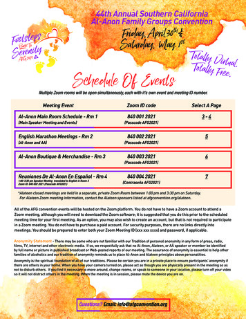
Transcription
National Aeronautics and Space AdministrationSchedule of Events at the NASA Booth2015Please join us at the NASA booth (#335), where we willshowcase a wide variety of science presentations andcutting-edge, interactive science, technology, and datademonstrations. This year’s program will be held Tuesday,December 15, through Friday, December 18, 2015. Hyperwallpresentations and In-Booth Science Flash Talks will cover arange of research topics, science disciplines, and programswithin www.nasa.gov
Hyperwall Presentation AgendaMonday, December 14TimeReception6:00 - 8:00 PMPresentationPresenterNASA’s Earth Observation Capabilities: Meeting the Challenges of Climate and Environmental ChangeDr. Michael FreilichRecent Discoveries in Planetary ScienceDr. Jim GreenHighlights of HeliophysicsMr. Steven ClarkeTuesday, December 159:45 - 10:00NASA and Wildfires: Science and Technology Supporting the NationDr. Vincent Ambrosia10:00 - 10:15Let’s Go! NASA’s “Eyes” Will Move YouMr. Kevin Hussey10:15 - 10:30Cassini and Saturn’s RingsDr. Linda Spilker10:30 - 10:45CALIPSO@10Dr. Chip Trepte10:45 - 11:002015 El Niño EventDr. David Halpern11:00 - 11:15Landsat and Sentinel 2Dr. Jeff Masek11:15 - 11:30NASA Global Climate Observations: Discover How Satellites See Climate ChangeDr. Jack Kaye1:00 - 3:00In-Booth Science Flash Talks3:30 - 3:45Finding Human Landing Sites on MarsDr. Jim Green3:45 - 4:00NASA’s Earth Observation Capabilities: Meeting the Challenges of Climate and Environmental ChangeDr. Michael Freilich4:00 - 4:15Solar System and BeyondDr. Michelle Thaller4:15 - 4:30Precipitation Viewed from SpaceDr. Gail Skofronick-Jackson4:30 - 4:45Sunny with a Chance of Solar StormsDr. Alex YoungSchedule on Page 4Wednesday, December 1629:45 - 10:00Watching the Earth Breathe: CO2 Measurements from the Orbiting Carbon Observatory-2 During ItsFirst Year in OrbitDr. David Crisp10:00 - 10:15NASA’s New Mars TrekMr. Brian Day10:15 - 10:30Disaster ManagementDr. David Green10:30 - 10:45NASA’s Earth Observation Capabilities: Meeting the Challenges of Climate and Environmental ChangeDr. Michael Freilich10:45 - 11:00Aqua Going StrongDr. Lazaros Oreopoulos11:00 - 11:15Ocean SalinityDr. Eric Lindstrom11:15 - 11:30Global Climate Simulation in High ResolutionDr. Bill Putman11:30 - 11:45NASA’s Astronaut Geology Training Program: Constraints, Benefits, and Humbling ExperiencesDr. Dean Eppler1:00 - 3:00In-Booth Science Flash Talks3:30 - 3:45NASA Global Climate Observations: Discover How Satellites See Climate ChangeDr. Jack Kaye3:45 - 4:00GEO Global Agricultural Monitoring Initiative: Earth Observation in Support of Food Security and Stable MarketsDr. Alyssa Whitcraft4:00 - 4:15GRACE Observations of Earth System Mass ChangeDr. Byron Tapley4:15 - 4:30SERVIR: Connecting Space to VillageMr. Eric Anderson4:30 - 4:45The Icy ArcticDr. Thomas Wagner4:45 - 5:00The Sun, Space Weather, and the FutureDr. Jeffrey NewmarkSchedule on Page 4
Hyperwall Presentation AgendaThursday, December 17TimePresentationPresenter9:45 - 10:00Observing Precipitation from SpaceDr. George Huffman10:00 - 10:15Wildfires and Smoke Emissions Around the WorldDr. Charles lchoku10:15 - 10:30Research Activities at the Short-term Prediction Research and Transition (SPoRT) CenterMr. Bradley Zavodsky10:30 - 10:45Observing Climate Change from SpaceDr. Martin Mlynczak10:45 - 11:00Sunny with a Chance of Solar StormsDr. Alex Young11:00 - 11:15NASA Health and Air Quality ApplicationsMr. John Haynes11:15 - 11:30Stratospheric Ozone Recovery / World AvoidedDr. Rich Eckman1:00 - 3:00In-Booth Science Flash Talks3:30 - 3:45NASA Technology, Observations, and Models Supporting Wildland Fire Science and ApplicationsDr. Amber Soja3:45 - 4:00OCO-2 UpdatesDr. Ken Jucks4:00 - 4:15What About the Clouds?Dr. Steve Platnick4:15 - 4:30Notable Changes in Air Pollution Around the WorldDr. Bryan DuncanSchedule on Page 4Friday, December 1810:00 - 10:15Revisiting the Apollo 17 Landing SiteDr. Noah Petro10:15 - 10:30Exploring NASA Earth Science DataMr. Daniel Oostra10:30 - 10:45Watching the Earth’s Surface ChangeDr. Joel McCorkel3
Flash Talks: Schedule-at-a-GlanceTuesday, December 15TimePresentationPresenter1:00 - 1:07Rain and Snow around the GlobeDr. George Huffman1:10 - 1:17Extending the Lunar Mapping and Modeling Portal – New Capabilities and New Worlds (DEMO)Brian Day1:20 - 1:27Sensing Air Quality from Space with NASA DISCOVER-AQDr. Andreas Beyersdorf1:30 - 1:37Rockets, Balloons, CubeSats, Oh My!Dr. Jeffrey Newmark1:40 - 1:47Hydrology by GPSDr. Susan Owen1:50 - 1:57It AppEEARS MODIS is Analysis Ready!Rob Quenzer2:00 - 2:07Using SMAP Soil Moisture Data to Estimate Rainfall RatesDr. Randal Koster2:10 - 2:17JunoCam: Science in a FishbowlDr. Candy Hansen2:20 - 2:27Drones that See Through Waves – New Technologies in Ocean Remote SensingDr. Ved Chirayath2:30 - 2:37CREATE-V: An Online Visualization Service for Exploring Climate Data (DEMO)Dr. Jerry Potter2:40 - 2:47NASA MODIS Data and Visualizations in the Time it takes to Make Popcorn!Suresh VanaanWednesday, December 161:00 - 1:07Discover NASA’s New Web Portal for Sea Level ChangeDr. Carmen Boening1:10 - 1:17Sifting through Granules: Enabling Earth Science Data Discovery through Earthdata SearchPatrick Quinn1:20 - 1:27Postcards from the Edge: How to Find and Use Imagery from Deep Space MissionsPhil DavisBill Dunford1:30 - 1:37NASA Soil Moisture Active Passive (SMAP) Mission Status and Early ResultsDr. Simon Yueh1:40 - 1:47Remote Sensing at your Fingertips: The LandCast Mobile App (DEMO)Rob Quenzer1:50 - 1:57The TIRCIS instrument: Hyperspectral Imaging from Small SatellitesDr. Robert Wright2:00 - 2:07KlAsh (Kelud Ash) - NASA Balloon Campaign Studies Effects of Volcanic EruptionDr. Jean-Paul Vernier2:10 - 2:17FINESSE: Walking the Moon. in IdahoDr. Shannon Kobs Nawotniak2:20 - 2:27The Solar Cycle: Impacts Felt at Maximum AND MinimumDr. Lika Guhathakurta2:30 - 2:37Training the World to Use NASA data with ARSETBrock Blevins2:40 - 2:47Metrics and Visualizations in the Astrophysics Data SystemEdwin Henneken2:50 - 2:57“Taste” the Plumes of Enceladus, and more, with NASA’s Eyes (DEMO)Kevin HusseyThursday, December 1741:00 - 1:07The Buzz about Bumblebee (DEMO)Donna Thompson1:10 - 1:17Monitoring Landslides from SpaceDr. Dalia Kirschbaum1:20 - 1:27NASA’s Airborne Missions from the Ends of the Earth (DEMO)Steve Tanner1:30 - 1:37Peering into the Permanently Shadowed Regions of the MoonDr. Wes Patterson1:40 - 1:47Seeing What the Satellites SeeDan PiloneEmily Northup1:50 - 1:57How Dry is Dry? Assessing Drought Severity in the Navajo Nation (DEMO)Vickie Ly2:00 - 2:07Imaging the Solar System at Spatial Scales varying by 12 Orders of MagnitudeDr. Timothy Glotch2:10 - 2:17Rooting Out the Problem: Mesquite Trees’ Effect on Estuary HealthGeorgina Crepps2:20 - 2:27The Hole Ozone StoryDr. Rich Eckman2:30 - 2:37CYGNSS: Measuring Surface Wind Speed in the Inner Core of Hurricanes from SpaceDr. Derek Posselt
Detailed Descriptions of Flash TalksTime/TitleDescriptionPresenterTuesday, December 151:00 - 1:07Rain and Snowaround the Globe1:10 - 1:17Extending theLunar Mappingand Modeling Portal– NewCapabilities andNew Worlds (DEMO)1:20 - 1:27Sensing Air Qualityfrom Space withNASA DISCOVER-AQ1:30 - 1:37Rockets, Balloons,CubeSats, Oh My!1:40 - 1:47Hydrology by GPS1:50 - 1:57It AppEEARSMODIS isAnalysis Ready!NASA scientists use almost a dozen satellites to keep track of rain and snow around theworld. The weather is always doing something! Come see what the last week of rainfalland snowfall patterns look like close to home and in remote areas of the globe. See up-todate movies of the rainfall that this year’s El Niño is creating. Has it lived up tothe forecasts?Dr. George HuffmanResearch Meteorologist,Deputy Project Scientist for GPM,NASA GSFCExplore new worlds with NASA’s Lunar Mapping and Modeling Portal (LMMP)! This webbased Portal and a suite of interactive visualization and analysis tools enable missionplanners, lunar scientists, and engineers to access mapped lunar data from past andcurrent lunar missions (lmmp.nasa.gov). Join us to view the latest and greatest interface,serving up improved ways to access and visualize NASA planetary data! Fasten yourseatbelt and join us on a virtual journey to the Moon, Vesta and Mars!Brian DayOutreach Lead,NASA Solar System ExplorationResearch Virtual Institute,NASA Ames Research CenterHow is NASA improving the remote sensing of air quality? By employing multiple aircraftand ground instrumentation, studies have been conducted in regions of the U.S. thatare currently in violation of federal air quality standards with the DISCOVER-AQ airbornecampaign. Join us to hear more about campaign results and how these results will be usedfor an international constellation of geostationary satellite observations of air quality in thenear future providing hourly observations over North America, Asia, and Europe.Dr. Andreas BeyersdorfResearch Scientist,NASA Langley Research CenterEver wonder how NASA trains young scientists or how NASA tests new technologies?The NASA Heliophysics Low Cost Access to space program does all this and more.Through sub-orbital rockets, stratospheric balloons larger than a football field, and downto near-softball size CubeSats, the Heliophysics Division utilizes a wide variety of flightopportunities to do the forefront science of understanding how the sun interacts with Earthand the solar system and to also foster the science capabilities of tomorrow.Dr. Jeffrey NewmarkHeliophysics Program Scientist,NASA HQWhen signals from the GPS satellites are reflected off the ground into a receivingantenna, changes in signal strength allow us to determine snow depth, soil moisture, andvegetation growth. A CU Boulder prototype system (xenon.colorado.edu/portal) makesthese measurements available for selected stations in the western U.S. NASA’s ESTOoffice is supporting JPL and CU Boulder to develop the technology to make this system formeasuring hydrological variables.Dr. Susan OwenEarth Surface andInterior Group Supervisor,NASA JPLWould you like to be able to subset MODIS land data products based upon point locations?NASA’s Land Processes Distributed Active Archive Center (LP DAAC) has developed a webapplication that allows users to subset point based, study relevant, land remote sensingdata. The Application for Extracting and Exploring Analysis Ready Samples (AppEEARS)provides an intuitive interface for accessing and extracting tiled MODIS data from theLP DAAC. Through AppEEARS, users can visualize and interact with extracted data valuesbefore download.Rob QuenzerSoftware Engineer,NASA Land Processes DistributedActive Archive Center (DAAC)5
Detailed Descriptions of Flash TalksTime/Title2:00-2:07Using SMAPSoil MoistureData to EstimateRainfall Rates2:10 - 2:17JunoCam:Science ina Fishbowl2:20 - 2:27Drones thatSee ThroughWaves – NewTechnologies inOcean RemoteSensing2:30 - 2:37CREATE-V:An OnlineVisualizationService forExploring ClimateData (Demo)2:40 - 2:47NASA MODIS Dataand Visualizations inthe Time it takes toMake Popcorn!6DescriptionPresenterThe NASA Soil Moisture Active-Passive (SMAP) satellite mission continues to provideDr. Randal Kosterhigh-quality estimates of soil moisture at the Earth’s surface. By analyzing these data inResearch Scientist,conjunction with contemporaneous precipitation data, we can characterize the drying of the NASA GSFCsoil during periods of no rain. This characterization allows us to manipulate the SMAP soilmoisture measurements into our own estimates of rainfall, estimates that are surprisinglyaccurate when compared against traditional rainfall products.NASA’s Juno spacecraft arrives at Jupiter in July 2016. Onboard the spacecraft is JunoCam, Dr. Candy Hansena color camera that will provide close-up views of Jupiter’s poles for the first time. The public Juno Co-Investigator,is an essential part of our virtual team: amateur astronomers will supply ground-basedPlanetary Science Instituteimages and the public will help in planning and processing of images, carrying out stepsordinarily reserved for professional scientists.The use of small, unmanned aerial vehicles (UAVs, commonly known as drones) andexperimental NASA-developed Fluid Lensing technology is presented as a novel means toimage underwater marine ecosystems from above the ocean’s surface, producing cm-scaleimagery in three dimensions over tens of square kilometers. Fluid Lensing uses watertransmitting wavelengths to passively image underwater objects by exploiting time-varyingoptical lensing events caused by refractive distortions from traveling surface waves.Dr. Ved ChirayathResearch Scientist,Earth Sciences Division,NASA AmesAs part of the Collaborative REAnalysis Technical Environment (CREATE), NASA ClimateModel Data Services has developed a unique online visualization tool for browsing throughmultiple reanalysis datasets. A reanalysis merges decades of observational data with aclimate model. With CREATE-V climate and non-climate scientists can visualize reanalysisdata while selecting variables, parameters, and color maps of interest. The tool will enabledecision makers to investigate recent global climate changes through time, inspect modeltrends, and compare reanalysis datasets.Dr. Jerry PotterSenior Project Scientist,Climate Model Data Services,Computational and InformationSciences and Technology Office,NASA GSFCMODIS (Moderate Resolution Imaging Spectroradiometer) land data are highly useful forfield research. However, the volume of MODIS data and the complexity of data format canmake using the data challenging! The problem is solved by using the NASA ORNL DAACMODIS Global Subsetting and Visualization Tool. This interface subsets, visualizes anddelivers the subsetted MODIS data in a matter of minutes allowing the users to conductpreliminary data analysis very quickly. For example, subsets and visualization for a 7x7 kmarea, for a 15-year time series can be delivered in less than 3 minutes!Suresh VanaanManager,NASA Oak Ridge National Laboratory(ORNL) DAACFor informationcds.nccs.nasa.gov/For informationdaac.ornl.gov/MODIS
Detailed Descriptions of Flash Talks (cont.)Time/TitleDescriptionPresenterWednesday, December 161:00 - 1:07Discover NASA’sNew Web Portalfor Sea LevelChange (DEMO)1:10 - 1:17Sifting throughGranules: EnablingEarth Science DataDiscovery throughEarthdata Search1:20 - 1:27Postcards fromthe Edge: Howto Find and UseImagery from DeepSpace Missions1:30 - 1:37NASA SoilMoisture ActivePassive (SMAP)Mission Statusand Early Results1:40 - 1:47Remote Sensingat your Fingertips:The LandCastMobile App (DEMO)1:50 - 1:57The TIRCISinstrument:HyperspectralImaging fromSmall SatellitesHow can we target today’s challenges in sea level change research? A new web portal hasbeen built to provide a one-stop shop for current NASA sea level data and information onsea level research. Through this portal, find out about the latest sea level research, exploredata analysis tools and quickly visualize and compare NASA data, such as sea surfaceheight, ocean temperatures, ice mass change, amongst others, on a global scale.Dr. Carmen BoeningResearch Scientist,NASA JPL, California Instituteof TechnologyNASA’s myriad of Earth-observing platforms provide scientists with continuous streamsof data; all focused on taking the pulse of our planet. The Earthdata Search tool providesstate-of-the-art web client for discovering, searching, visualizing, and retrieving that Earthscience data in an intuitive and engaging way. This demo will highlight Earthdata Search’scapabilities; walking participants through the search interface and showcasing the ease ofdata access.Patrick QuinnLead Developer,NASA Earthdata Search,Element 84, Inc.Give us six minutes, and we’ll give you the entire solar system. It’s never been easier tofind and use raw images and other data from the full range of deep space missions. Thisincludes archives of historic data, as well as the latest pictures hot off the Deep SpaceNetwork. In this brief tool demo, we’ll show you the latest and greatest ways to find thedata. We’ll also show how NASA, other agencies, and even members of the public areputting these images to spectacular use in creating interest in and explaining the latestplanetary and Earth science.Phil DavisWeb Producer,NASA Solar System ExplorationBill DunfordScience Writer,NASA Solar System ExplorationNASA’s Soil Moisture Active Passive (SMAP) mission was launched on January 31, 2015.Dr. Simon YuehThe mission objective is to monitor the global surface state of the terrestrial water cycle.SMAP Project Scientist,Soil moisture dynamics link the water, energy and carbon cycles over land.NASA JPLWe present the latest observations and science applications of the mission data. Themission data are also being applied to derive novel new observations for ocean science andglobal ecology.To extend the reach of land remote sensing data to the public earth science community,NASA’s Land Processes Distributed Active Archive Center (LP DAAC) has developed theLandCast mobile application. LandCast allows users to visualize a variety of the Earth’ssurface features over time and space. Users can immediately share visualizations withcolleagues via social media or email. This talk will demonstrate all that LandCast has tooffer as a data interaction and visualization tool.Rob QuenzerSoftware Engineer,NASA LP DAACHyperspectral imaging is being used to help understand the chemical composition ofgeologically relevant targets, including volcanic gas and ash clouds, and the mineralogyand chemistry of rocks and minerals. NASA is developing an instrument (TIRCIS) that usesa uncooled microbolometer and a Fabry-Perot interferometer to acquire hyperspectralimages in the long-wave infrared.Dr. Robert WrightAssociate Researcher,Hawaii Institute of Geophysicsand Planetology7
Detailed Descriptions of Flash TalksTime/Title2:00 - 2:07KlAsh (Kelud Ash)- NASA BalloonCampaign StudiesEffects of VolcanicEruption2:10 - 2:17FINESSE:Walking the Moon.in Idaho2:20 - 2:27The Solar Cycle:Impacts Felt atMaximum ANDMinimum2:30 - 2:37Training theWorld to UseNASA datawith ARSET2:40 - 2:47Metrics andVisualizations inthe AstrophysicsData System2:50 - 2:57“Taste” thePlumes ofEnceladus,and more, withNASA’s Eyes (DEMO)8DescriptionPresenterVolcanic events can have profound and important effects on climate and also interfere withhuman activities, for example, the presence of ash in flight corridors can have a cripplingimpact on aviation. In collaboration with the University of Wyoming and partnering withthe Australian Bureau of Meteorology the KlAsh (Kelud Ash) experiment based in Darwin,Australia, a series of instrumented balloons were deployed in May 2014 to characterizeparticle sizes, composition, and optical properties from a volcanic plume in the stratosphereemanating from Mount Kelud, Indonesia.Dr. Jean-Paul VernierResearch Scientist,Science Systems and Applications, Inc.,NASA Langley Research CenterThe volcanoes of Craters of the Moon National Monument, Idaho, provide an analog viewinto volcanic features on planetary bodies. Lava flows, blast pits, and rilles allow us toextrapolate terrestrial stories via field work, remote sensing, and modeling.Dr. Shannon Kobs NawotniakAssistant Professor,Idaho State UniversityLearn about the extremes of solar variability and how they affect life and society. Only afew years ago, the sun emerged from the deepest Solar Minimum in a hundred years.During this extreme quiet the solar wind became slow and weak; solar storms lost theirpunch; and cosmic rays hit a record high for the Space Age. Instead of a vigorous SolarMaximum in the 2010s, we experienced a “mini Solar Max” with fewer intense flares andfewer storms that impacted Earth’s technologies.Dr. Lika GuhathakurtaProgram Scientist,Living with a StarNASA’s Applied Remote Sensing Training Program (ARSET), (arset.gsfc.nasa.gov) providesprofessional training worldwide. We help decision-makers navigate through the vast,freely available and open data resources; the ultimate goal is to develop the technical andanalytical skills necessary to utilize NASA resources for decision-support. We reached 2000 stakeholders and 130 countries in 2015 alone. Upcoming trainings will covertopics including Advanced Tools for High Resolution Air Quality Satellite Data Sets and youcan register for future trainings through our website.Brock BlevinsNASA ARSET Program,University of Maryland Baltimore CountyThe SAO/NASA Astrophysics Data System (ADS) is the digital library used by scientistsworldwide to stay up-to-date with literature. The ADS also maintains a citation database.This makes the ADS an environment that is very suitable for calculating metrics. The ADS hasdeveloped both metrics and visualization services. These support both calculation of metricsand visualizations for individual researchers, but also for programs and instruments.Edwin HennekenIT Specialist,Smithsonian Astrophysical ObservatoryJoin our planetary explorers as they travel far and wide throughout our Solar System!Experience the first person drama of flying through the icy plumes of Enceladus, at over19,000 miles an hour and under 30 miles from its surface, while “looking around” at thespectacular surroundings of Saturn. You will learn how simple it is to become an arm chairplanetary explorer so you can be ready to join Juno as she enters orbit around Jupiter andInsight as she lands on Mars, both next year.Kevin HusseyManager, Visualization TechnologyApplications and Development,NASA JPLFor informationeyes.nasa.gov
Detailed Descriptions of Flash Talks (cont.)Time/TitleDescriptionPresenterThursday, December 171:00 - 1:07The Buzz aboutBumblebee (DEMO)1:10 - 1:17MonitoringLandslidesfrom Space1:20 - 1:27NASA’s AirborneMissions fromthe Ends of theEarth (DEMO)1:30 - 1:37Peering into thePermanentlyShadowed Regionsof the Moon1:40 - 1:47Seeing what theSatellites SeeThe NASA Astrophysics Data System (ADS) is a Digital Library portal containing thejournal literature of astronomy and physics. Our new interface (nicknamed “Bumblebee”)has some exciting new updates that streamline your searching of our extensive databasewhich includes journal literature used daily be geophysical researchers. Come and seesome new searching tips! Even if you’ve used ADS in the past, you’ll be sure to appreciatethe updates.Donna ThompsonLibrarian, SmithsonianAstrophysical ObservatoryLandslides cause thousands of fatalities every year, result in billions of dollars in lossesand occur in nearly every country in the world. Through satellite data, models and even themedia we explore how we can evaluate this pervasive in near real-time! Learn about someof the exciting ways in which NASA is exploring where, when and how landslides impactour world.Dr. Dalia KirschbaumResearch Scientist,NASA GSFCThe Operation IceBridge Development Team at the NASA National Snow and Ice DataCenter Distributed Active Archive Center (NSIDC DAAC) is developing a new IceBridge dataportal that takes full advantage of the metadata now being generated. Using an interactivemap built to highlight the IceBridge flights in the Arctic and Antarctic and the data theygathered, users can quickly find, select and download the products they need. The Betaversion of the portal will be shown.Steve TannerIceBridge and ICESat-2 Data Manager,NASA National Snow and Ice DataCenter DAACThe Miniature Radio Frequency (Mini-RF) instrument on NASA’s Lunar ReconnaissanceOrbiter (LRO) is a Synthetic Aperture Radar (SAR) capable of illuminating and measuringthe characteristics of regions of the Moon that are permanently shadowed from the Sun.The information provided by these measurements is casting a new light on these elusiveregions and will feed future NASA exploration goals.Dr. Wes PattersonMini-RF Principal Investigator,Johns Hopkins UniversityApplied Physics LaboratoryThe Global Imagery Browse Services (GIBS) provide a rich visual interface to NASA’sextensive collection of Earth science data products. Web mapping interfaces such asNASA’s Worldview and State of the Oceans utilize GIBS to access near real-time andhistorical satellite imagery of high-value geophysical parameters (temperature, rainfall,reflectance) from a growing number of instruments (MODIS, AIRS, GPM). Join us to learnhow these services may benefit you!Dan PiloneEED-2 Chief Technologist,NASA GSFC / Element 84, Inc.Emily NorthupAssociate Scientific Analyst,NASA LaRC DAAC9
Detailed Descriptions of Flash TalksTime/Title1:50 - 1:57How Dry is Dry?AssessingDrought Severityin the NavajoNation (DEMO)2:00 - 2:07Imaging theSolar Systemat Spatial Scalesvarying by12 Orders ofMagnitude2:10 - 2:17Rooting Out theProblem: MesquiteTrees’ Effect onEstuary HealthDescriptionPresenterSevere drought events, climate change, and the lack of water infrastructure and economicresources has impacted water resource management in the Navajo Nation. To bettermonitor drought regime changes, this project created a decision support tool to calculateaverage Standardized Precipitation Index values for user-specified areas. With the tool,Navajo Nation resource managers will be able to use NASA Earth observation data forincreased decision-making capacity on the impact of climate change on water resources.Vickie LyFellow, NASA DEVELOP Program,NASA Ames Research CenterThe RIS4E team is advancing the science and future exploration of the Moon, Near EarthAsteroids, Phobos, and Deimos. We study satellite data encompassing broad swaths ofplanetary surfaces and conduct laboratory analyses of extraterrestrial materials down to 1 Angstrom. Find out how we are learning about the Solar System at spatial scales thatvary by over 12 orders of magnitude.Dr. Timothy GlotchAssociate Professor of Geosciences,Stony Brook UniversityThis project partnered with the National Park Service to address concerns regarding theGeorgina Creppssalinity of the Laguna Madre in the Padre Island National Seashore. NASA Earth observation Impact Analysis Senior Fellow,data were utilized to analyze precipitation, land cover, root zone soil moisture, and thermal NASA DEVELOP Program, NASA LaRCimagery of the lagoon. These products were ultimately used to understand the suspectedpositive correlation between the increased salinity of the lagoon and the increasedoccurrence of mesquite trees in the surrounding area.2:20 - 2:27The discovery of the Antarctic ozone hole in 1985 led to unprecedented efforts tounderstand its cause and impacts. Accurate measurements led to global action - theThe Hole Ozone Story Montreal Protocol has resulted in dramatic decreases of ozone-depleting substances.Satellite-based observations play a vital role in assessing the state of the ozone layerand the SAGE III instrument to be launched next year will continue that role from theInternational Space Station.Dr. Rich EckmanProgram Manager,Atmospheric CompositionModeling & Analysis Program2:30 - 2:37Dr. Derek PosseltUniversity of MichiganMeasuringSurface WindSpeed in the InnerCore of Hurricanesfrom Space10Winds and wind-driven storm surge cause most of the catastrophic damage in land-fallinghurricanes, yet current satellites are unable to sense winds near the storm center. TheCyclone Global Navigation Satellite System (CYGNSS) will launch in October 2016, and willmeasure previously unobservable surface winds in and near the inner core of hurricanes.This information will help to improve model forecasts of hurricane intensity, aiding inprotecting human health and welfare.
NOTES11
NASA’s VisionTo reach for new heights and revealthe unknown so that what we do andlearn will benefit all ov/hwNational Aeronautics and Space Administrationwww.nasa.gov
10:15 - 10:30 Cassini and Saturn’s Rings Dr. Linda Spilker 10:30 - 10:45 CALIPSO@10 Dr. Chip Trepte 10:45 - 11:00 2015 El Niño Event Dr. David Halpern 11:00 - 11:15 Landsat and Sentinel 2 Dr. Jeff Masek 11:15 - 11:30 NASA Global Climate Observations: