Transcription
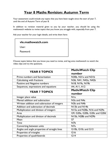
YEAR 7REVISION BOOKLETAssessment checklist1. To be able to define Geography.2. Give examples of what we study in geography3. Group what we study into the three major areas of geography4. To be able to define and label the continents.5. To be able to define and label the oceans6. To be able to use an 8 direction compass.7. To be able to describe the location of countries in Europe using cardinal points.8. To be able to use a key9. To be able to use a scale10. To be able to read height on a map11. To be able to use four figure grid references to describe the location of apoint on a map.12. To be able to use four figure grid references on an OS map.13. To be able to use six figure grid references on an OS map.14. To be able to recognise symbols on an OS map.15. To be able to use scale on a OS maps16. To be able to measure the distance between two six figure grid referenceson an OS map.17. To understand how we can show relief on a flat surface.18. To be able to use contour lines to work out how high places are.19. To be able to use contour lines to draw cross sections of areas to scale.20. To be able to describe a route using only an OS map.
What is geography?Geography is the study of the world. It examines how people and natureinteract.The study of geography can be split into HUMAN, PHYSICAL & ENVIRONMENTAL.Here are some of the topics you will study in geography:- Ecosystems- Natural Hazards- Map Skills- Population and Migration- Pollution- Tourism- Coasts- Energy- Rivers1.0 Locational knowledge1.1 World mapThe world has seven continents and five oceans.Europe is a continent. It is an area on the Earth that contains many differentcountries, including the UK.The United Kingdom of Great Britain and Northern Ireland is made up of England, Northern Ireland, Scotland and Wales.The countries are divided further into regions.Counties are smaller areas. For example the counties of Dorset, Gloucestershire, Wiltshire, Devon and Cornwall are all part of the South West region.
NORTHWESTEASTSOUTH
Geographers have traditionally used maps as a source of information aboutplaces. We can now use a range of technology to help us find places, eg satellite navigation, GPS and GIS on our computers or mobile phones.A map is a two-dimensional drawing of an area. Maps help us to understandwhat places are like and how to plot routes.Maps should have a: titlescalenorth arrowkey or legendSymbolsSymbols help us to include lots of detail onmaps that are drawn to scale. They includesimple images, letters and abbreviations. Hereare some examples:Direction, scale, distanceand heightDirectionTry to remember the main compass points byusing a mnemonic, egNaughty Elephants Squirt Water - North EastSouth WestThe four main points of the compass are north,east, south and west. Half way between eachof these there are four other points: north-east,south-east, south-west and north-west. Thismakes an eight-point compass. There are afurther eight points between these - rememberthe names of these are a mix of the two closest compass points but they always start withthe main compass point, ie north, east, southor west.Ordnance Survey maps are always printed sothat north is at the top of the map.
Scale and distanceMost maps have a scale. These help us to work out distances on maps. Thisis given by the scale statement (eg 1:25,000) and/or by showing a scale bar.The scale shows how much bigger the real world is than the map. If the scaleis 1:50,000 it means that the map is 50,000 times smaller than the real world.For example, every 1 cm on the map represents 50,000 cm in the real world.
PRACTICE QUESTIONS
Use the images on the next page to help you answer these questions
Plan your own route48BA4746C452021222324You have decided to go on a walk with some friends. Study the map extract aboveof the Isle of Wight, which shows the two routes you can choose for your journey,from A to B or A to C.SCALE: 4cm 1kmNote:The following shows the average walking speed for a person:On flat ground: 1 hour to travel 4kmOn steep ground: 1 hour to travel 3km
Describe the route you would choose Give the 6 figure grid reference of the starting and finishing point of yourjourney. The direction you are travelling. The steepness/Gradient of land. Distance Travelled. Time taken.I would choose the route �—————————————
YEAR 7 REVISION BOOKLET Assessment checklist 1. To be able to define Geography. 2. Give examples of what we study in geography 3. Group what we study into the three major areas of geography 4. To be able to define and label the continents. 5. To be able to define and label t