Transcription
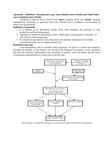
Agronomy – definition – meaning and scope. Agro-climatic zones of India and Tamil Nadu –Agro ecological zones of IndiaAgronomy is derived from a Greek word ‘agros’ meaning ‘field’ and ‘nomos’ meaning‘management’. Principles of agronomy deal with scientific facts in relations to environment inwhich crop are produced.Definition of Agronomy1. It is defined as an agricultural science deals with principles and practices of cropproduction and field management.2. Agronomy is branch of agricultural science, which deals with principles, & practices ofsoil, water & crop management.3. It is branch of agricultural science that deals with methods which provide favorableenvironment to the crop for higher productively,Boundaries and scaleCrop management, and its scientific study agronomy, are part of a system that comprisesthe physical elements of the climate, soil and land, the biological constituents of the vegetationand soil, the economic opportunities and constraints of markets, sales and profit, and the socialcircumstances and preferences of those who work the land.
Scope of AgronomyAgronomy is a dynamic discipline with the advancement of knowledge and betterunderstanding of planet, environment and agriculture. Agronomy science becomes imperative inAgriculture in the following areas. Identification of proper season for cultivation of wide range of crops is needed which couldbe made possible only by Agronomy science. Proper methods of cultivation are needed to reduce the cost of cultivation and maximizethe yield and economic returns. Availability and application of chemical fertilizers has necessitated the generation ofknowledge to reduce the ill-effects due to excess application and yield losses due to theunscientific manner of application. Availability of herbicides for control of weeds has led to development for a vastknowledge about selectivity, time & method of its application. Water management practices play grater role in present day crisis of water demand andAgronomy science answer to the questions ‘how much to apply?’ and ‘when to apply?’. Intensive cropping is the need of the day and proper time and space intensification not onlyincrease the production but also reduces the environmental hazards. New technology to overcome the effect of moisture stress under dry land condition isexplored by Agronomy and future agriculture is depends on dry land agriculture. Packages of practices to explore full potential of new varieties of crops are the mostimportant aspects in crop production which could be made possible only by Agronomyscience. Keeping farm implements in good shape and utilizing efficient manner to nullify thepresent day labour crisis is further broadening the scope of agronomy. Maintaining the ecological balance through efficient management of crops, livestock andtheir feedings in a rational manner is possible only by knowing agronomic principles. Care and disposal of farm and animal products like milk and eggs and proper maintenanceof accounts of all transactions concerning farm business is governing principles ofagronomy.Relation of agronomy to other sciencesAgronomy is a main branch of Agriculture. It is synthesis of several disciplines like soilscience, Agricultural chemistry, crop physiology, plant ecology, biochemistry and economics. The Soil Science helps the agronomist to thoroughly understand the soil physical, chemicaland biological properties to effect modification of the soil environment. The Agricultural Chemistry help the agronomist to understand the chemical compositionand changes involved in the production, protection, and use of crops and livestock. The crop physiology helps to understand the basic life process of crops to understandfunctioning of each parts of plant to determine their input requirement like nutrients etc. The plant ecology helps us to understand the associated environment in which the cropsgrown like the influence of weather (Temperature, Rainfall etc). The biochemistry shows the way in which biochemical process takes place in crops whichhelps to understand critical requirements to favourably activate this process. The economics paves the way for profit and loss analysis in farming.
Role of AgronomistAgronomist is a scientist who is dealing with the study of problems of crop production andadopting/recommending practices of better field crop production and soil management to get highyield and income. Agronomist aims at obtaining maximum production at minimum cost by exploiting theknowledge of the basic and applied sciences for higher crop production. In a broader sense, agronomist is concerned with production of food and fibre to meet theneeds of growing population. He develops efficient and economic field preparation method for sowing crops in differentseason. (Flat bed, Ridges and furrows) He is also involved to selection of suitable crop and varieties to suit or to match variedseasons and soils. Eg. Red soil - groundnut, Black soil - cotton, Sandy soil – tuberouscrops, Saline soil – Finger millet (Ragi). In Kharif if water is sufficient go for rice andwater is not sufficient go for maize, sorghum. Evolves efficient method of cultivation (whether broadcasting, nursery and transplantationor dibbling, etc.) provides better crop establishment and maintain required population He has to identify various types of nutrients required by crops including time and methodof application (e.g. for long duration rice (150-60-60 kg NPK), short duration: 120:50:50kg NPK/ha Application P&K basal and N in three splits) Agronomist must select a better weed management practice. Either through mechanical orphysical (by human work) or chemical (herbicides or weedicides, e.g. 2-4-D) or cultural(by having wide space it may increase weed growth by using inter space crops). Weedsare controlled by integrated weed management method also Selection of proper irrigation method, irrigation scheduling i.e. irrigation timing andquantity based on the crops to be irrigated, whether to irrigate continuously or stop inbetween and how much water to be supplied are computed by agronomy science so as toachieve maximum water use efficiency. Crop planning (i.e.) suitable crop sequence are developed by agronomist (i.e.) what type ofcrop, cropping pattern, cropping sequence, etc. (Rice - Rice - Pulse) Agronomists are also develops the method of harvesting, time for harvesting, etc.(Appropriate time of harvest essential to prevent yield loss) Agronomist is responsible for every decision made in the farm management. (What typeof crop to be produced? How much area to be allotted for each crop? How and when tomarket? How and When to take other management activities?) All the decisions should betaken at appropriate time to efficiently use resources available)Agro-climatic zonesAn agro-climatic zone is a land unit uniform in respect of climate and length of growingperiod (LGP) which is climatically suitable for a certain range of crops and cultivars (FAO, 1983).Classification by Planning CommissionPlanning Commission of India (1989) made an attempt to delineate the country intodifferent agro climatic regions based on homogeneity in rainfall, temperature, topography,cropping and farming systems and water resources. India is divided into 15 agro-climatic regions.1. Western Himalayan zoneThis zone consists of three distinct sub-zones of Jammu and Kashmir, Himachal Pradeshand Uttar Pradesh hills. The region consists of skeletal soils of cold region, podsolic mountain
meadow soils and hilly brown soils. Lands of the region have steep slopes in undulating terrain.Soils are generally silty loams and these are prone to erosion hazards.2. Eastern Himalayan zoneSikkim and Darjeeling hills, Arunachal Pradesh, Meghalaya, Nagaland, Manipur, Tripura,Mizoram, Assam and Jalpaiguri and Coochibihar districts of West Bengal fall under this region,with high rainfall and high forest cover. Shifting cultivation is practiced in nearly one-third of thecultivated area and this has caused denudation and degradation of soils with the resultant heavyrunoff, massive soil erosion and floods in lower reaches and basins.3. Lower Gangetic Plains zoneThis zone consists of West Bengal-lower Gangetic plain region. The soils are mostlyalluvial and are prone to floods.4. Middle Gangetic Plains zoneThis zone consists of 12 districts of eastern Uttar Pradesh and 27 districts of Bihar plains.This zone has a geographical area of 16 million hectares and rainfall is high. About 39% of grosscropped area is irrigated and the cropping intensity is 142%.5. Upper Gangetic Plains zoneThis zone consists of 32 districts of Uttar Pradesh. Irrigation is through canals and tubewells. A good potential for exploitation of ground water exists.6. Trans-Gangetic Plains zoneThis zone consists of Punjab, Haryana, Union territories of Delhi and Chandigarh andSriganganagar district of Rajasthan. The major characteristics of this area are: highest net sownarea, highest irrigated area, high cropping intensity and high groundwater utilization.7. Eastern Plateau and Hills zoneThis zone consists of eastern part of Madhya Pradesh, southern part of West Bengal andmost of inland Orissa. The soils are shallow and medium in depth and the topography isundulating with a slope of 1-10%. Irrigation is through tanks and tube wells.8. Central Plateau and Hills zoneThis zone comprises of 46 district of Madhya Pradesh, part of Uttar Pradesh andRajasthan. The topography is highly variable nearly 1/3rd of the land is not available forcultivation. Irrigation and cropping intensity are low. 75% of the area is rainfed grown with lowvalue cereal crops. There is an intensive need for alternate high value crops including horticulturalcrops.9. Western Plateau and Hills zoneThis zone comprises the major part of Maharastra, parts of Madhya Pradesh and onedistrict of Rajasthan. The average rainfall of the zone is 904 mm. The net sown area is 65% andforests occupy 11%. The irrigated area is only 12.4% with canals being the main source.10. Southern Plateau and Hills zoneThis zone comprises 35 districts of Andhra Pradesh, Karnataka and Tamil Nadu which aretypically semi-arid zones. Dryland farming is adopted in 81% of the area and the croppingintensity is 111 percent.11. East Coast Plains and Hills zoneThis zone comprises of east coast of Tamil Nadu, Andhra Pradesh and Orissa. Soils aremainly alluvial and coastal sands. Irrigation is through canals and tanks.12. West Coast Plains and Ghats zoneThis zone comprises west coast of Tamil Nadu, Kerala, Karnataka, Maharastra and Goawith a variety of crop patterns, rainfall and soil types.13. Gujarat Plains and Hills zone
This zone consists of 19 districts of Gujarat. This zone is arid with low rainfall in mostparts and only 32.5% of the area is irrigated largely through wells and tube wells.14. Western Dry zoneThis zone comprises nine districts of Rajasthan and is characterized by hot sandy desert,erratic rainfall, high evaporation, scanty vegetation. The ground water is deep and often brackish.Famine and drought are common features of the region.15. Islands zoneThis zone covers the island territories of Andaman and Nicobar and Lakshadeep which aretypically equatorial with rainfall of 3000 mm spread over eight to nine months. It is largely aforest zone with undulated lands.123456789101112Western Himalayan RegionEastern Himalayan RegionLower Gangetic Plains RegionMiddle Gangetic Plains RegionUpper Gangetic Plains RegionTrans-Gangetic Plains RegionEastern Plateau and Hills RegionCentral Plateau and Hills RegionWestern Plateau and Hills RegionSouthern Plateau and Hills RegionEast Coast Plains and Hills RegionWest Coast Plains and Ghat RegionJ&K, HP, UP, UtranchalAssam Sikkim, West Bengal & North-Eastern statesWest BengalUP, BiharUPPunjab, Haryana, Delhi & RajasthanMaharastra, UP, Orissa & West BengalMP, Rajasthan, UPMaharastra, MP & RajasthanAP, Karnataka, Tamil NaduOrissa, AP, TN,& PondicheryTN, Kerala, Goa, Karnataka, Maharastra
13 Gujarat Plains and Hills Region14 Western Dry Region15 The Islands RegionGujaratRajasthanAndman & Nicaobar, Lakshya DeepClassification by ICARThe State Agricultural Universities were advised to divide each state into sub-zones, underthe National Agricultural Research Project (NARP) under ICAR. Based on the rainfall pattern,cropping pattern and administrative units, 127 agro-climatic zones are classified. The zones ofeach state are given below.StateNo. of zonesStateNo. of zonesAndhra Pradesh7Madhya 8North Eastern Hill region6Haryana2Orissa9Himachal Pradesh4Punjab5Jammu and Kashmir4Tamil Nadu7Karnataka10Uttar Pradesh10Kerala8West Bengal6The state of Tamil Nadu has been classified into seven distinct agro-climatic zones listedbelow.1. North Eastern zone2. North Western zone3. Western zone4. Cauvery Delta zone5. Southern zone6. High Rainfall zone7. Hilly zone1. North Eastern zoneThis zone covers the districts of Thiruvallur, Vellore, Kanchipuram, Thiruvannamalai,Viluppuram, Cuddalore (excluding Chidambaram and Kattumannarkoil taluks), some parts ofPerambalur including Ariyalur taluks and also Chennai. The mean annual rainfall of this region is1054 mm received in 53 rainy days and is benefited by both the monsoons. The mean monthlymaximum temperature ranges between 28.2 to 38.9 C and the minimum ranges from 19.5 to24.8 C.2. North Western zoneThis zone comprises of Dharmapuri and Krishnagiri district (excluding hilly areas), Salem,Namakkal district (excluding Tiruchengode taluk) and Perambalur taluk of Perambulur district.The climate prevailing in this region is dry and sub humid. This region has been identified asmoderately drought prone area. The elevation varies from 330 to 1070 m above mean sea level.The mean annual rainfall of this region is appreciably lower than in North Eastern zone and is 825mm received in 47 rainy days. The region is benefited by both south-west and north-east monsoonrains but unlike the NEZ, the former contributed more to the total rainfall. The mean monthlymaximum temperature ranges between 30 to 37 C with minimum temperature ranging between 19to 25.5 C. The annual PET of this region is 1727 mm compared to the annual precipitation of 825mm.
3. Western zoneThis zone comprises of Erode, Coimbatore, Dindigal, Theni districts, Tiruchengode talukof Namakkal district, Karur taluk of Karur district and some western part of Madurai district. Themean annual rainfall is 718 mm in 45 rainy days. The monthly mean maximum temperature is35 C in April and 30 C in January and November. The monthly mean minimum temperature is19 C in January and 24 C in May.4. Cauvery Delta zoneThis zone comprises the Cauvery Delta area in Thanjavur, Thiruvarur, Nagapattinamdistricts and Musiri, Tiruchirapalli, Lalgudi, Thuraiyur and Kulithalai taluks of Tiruchirapallidistrict, Aranthangi taluk of Pudukottai district and Chidambaram and Kattumannarkoil taluks ofCuddalore district. The mean annual rainfall of the zone is 1078 mm out of which 40mm isreceived during winter, 69.2mm during summer, 295.4mm during South West Monsoon and673.8mm during North East Monsoon.5. Southern zoneThis is the biggest among the seven zones of Tamil Nadu. It is typical zone surrounded bycoastal areas on the East and mountains in the West. This zone comprises Sivagangai,Ramanathapuram, Virudunagar, Tuticorin and Tirunelveli districts and Natham and Dindigultaluks of Dindigul district, Melur, Tirumangalam, Madurai South and Madurai North taluks ofMadurai district and Pudukkottai district excluding Aranthangi taluk. This zone lies on theSouthern part of the State under rain shadow area. Because of this, the area is prone to droughtvery often. The climate is semi-arid tropics. The elevation varies from mean sea level to 300 m.The mean annual rainfall is 776 mm received in 43 rainy days. The monthly mean maximumtemperature in this region ranges from 28.5 C in December to 38.5 C in June. The monthly meanminimum temperature varies from 21.0 C in January to 27.5 C in June.6. High rainfall zoneThis zone consists of Kanayakumari district. This district situated in the southern most partof the Peninsular India, with its high rainfall having a climate which is entirely different from therest of the state. The climate is monsoon tropics and there is seasonal in shores flow of moist air.The elevation ranges from sea level to about 600 m. The mean annual rainfall of the district is1469 mm received in 64 rainy days. There is not much fluctuation in the mean monthly airtemperature. The monthly mean maximum temperature varies from 28.0 C in December to 33.5 Cin May. The monthly mean minimum temperature varies from 22 C in December to 26.5 C inMay.7. High altitude and Hilly zoneThis zone comprises the hilly regions, namely the Nilgiris, Shevroys, Elagiri-Javvadhu,Kollimalai, Patchaimalai, Anamalais, Palanis and Podhigaimalais. The rainfall varies from 850mm in Kalrayan hills to about 4500 mm in Anamalai hills.Agro-ecological zones of IndiaAn ecological region is characterized by distinct ecological responses to macroclimate asexpressed in vegetation and reflected in soils, fauna and aquatic systems. Therefore, an agroecological region is the land unit on the earth’s surface carved out of agro-climatic region whensuperimposed on different landform and soil conditions that act as modifiers of climate and lengthof growing period (LGP).National Bureau of Soil Survey and Land Use Planning (NBSS & LUP) of the ICAR hasdelineated 20 agro-ecological regions (AERs) in the country using the FAO 1978 concept ofsuperimposition of length of growing periods and bio-climate maps on soil physiographic map.Arid ecosystem
1. Western Himalayas, cold eco-region, shallow soils, LGP 90 days.2. Western plain Kachohh and parts of Kathiawar Peninsula, hot arid eco-region, desert andsaline soils. LPG 90 days.3. Deccan plateau, hot arid ecoregion, red and black soils. LGP 90 days.Semiarid ecosystem4. Northern plain and central high lands, hot semiarid eco-region, alluvial soils. LGP 90-150days.5. Central high lands, Gujarat plains, Kathiawar peninsula, hot semiarid eco-region, mediumand deep black soils. LGP 90-150 days.6. Deccan plateau, hot semiarid ecoregion. LGP 90-150 days.7. Telangana, Eastern ghats, hot semiarid eco-region. LGP 90- 150 days.8. Eastern ghats, Tamil Nadu uplands and Karanataka plateau, hot semiarid eco-region. LGP90-150 days.Subhumid Ecosystem9. Northern plain, hot sub-humid (dry) eco-region, red and black soils. LGP 150-180 days.10. Central highlands, hot sub-humid eco-region, black and red soils. LGP 150-180 (210)days.11. Eastern plateau, hot sub-humid eco-region, red and yellow soils, (210) days. LGP 150-180days.12. Eastern plateau (Chotanagpur) and Eastern ghats hot sub-humid eco-region, red andlateritic soils. LGP 150-180 (210) days.13. Eastern plain, hot sub-humid (moist) eco-region, alluvial soils. LGP 180-210 days.14. Western Himalayas, warm sub-humid to humid eco-region with brown forest soils. LGP180-210 days.Humid-Perhumid ecosystem15. Bengal and Assam plain hot sub-humid (moist) to humid eco-region, alluvial soils. LGP210 days.16. Eastern Himalayas, warm per-humid eco-region, brown and red hill soils. LGP 210 days.17. North eastern hills, warm per-humid eco-region, red and lateritic soils. LGP 210 days.Coastal Ecosystem18. Eastern coastal plain, hot sub-humid to semiarid eco-region, coastal alluvium. LGP 90-210 days.19. Western Ghats and coastal plain, hot humid-per-humid eco-region, red, lateritic andalluvium derived soils. LGP 210 days.Island Ecosystem20. Andaman Nicobar and Lakshadeep, hot humid to per-humid eco-region, real loamy andsandy soils. LGP 210 days.The major advantage of LGP based criteria is that the LGP is the direct indicative of moistureavailability of a given landform rather than the total rainfall. For example, both Ratnagiri inwestern Maharashtra and Nagpur in eastern Maharashtra have LGP 180-210 days but the totalannual rainfall of Ratnagiri is more than 2000 mm where as that of Nagpur is only 1100 mm.Therefore, agro-ecosystems approach allows crop planning based on length of growing periodrather than the quantity of rainfall.
Agronomy is derived from a Greek word . agros’ meaning ‘field’ and ‘ nomos’ ‘meaning ‘management’. Principles of agronomy deal with scientific facts in relations to environment in which crop are produced. Definition of Agronomy. 1. It is defined as an agricultural science deals with principles and practices of cropFile Size: 220KB