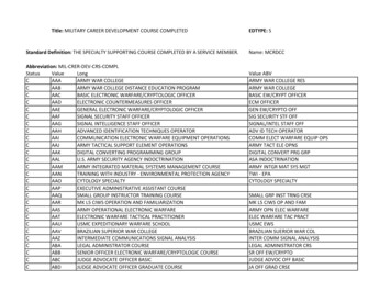
Transcription
GUILDERLAND BICYCLE & PEDESTRIAN CONNECTIVITY STUDY: h ps://cu .ly/TOG-UAlbany Completed with Graduate planning students with Kate Maynard, AICP as Instructor. Feedback from thecommunity/stakeholderinterviews, Recommenda ons from thepast plans and studies, Proposed & planned trails andbikeways by a range of agencies,organiza ons, municipali es andprivate en es Community Engagement including stakeholder interviews and well a ended public mee ng - This collec ve efforthelped inspire this plan’s recommenda ons that will address the needs of the community. The results of the public survey and prioriri za on tool Development of design guidelines Cost es ma on of priori zed trail segments Level ofSerivce The priori za on framework is a flexible approach,intended to provide clear direc on for seeking projectfunds and comple ng design and engineering of themost cri cal projects, while s ll allowing foropportunis c implementa on of the en re upportFacilitiesh ps://cu oryCommitteeh ps://cu .ly/TOG-publicinputADOPTIONTOWN OF GUILDERLANDAddi onal Studio project ideas for your community?Contact Kate Maynard at: ktmaynard@albany.edu
Protec on of natural areas and wildlife habitat/corridors:sensi ve environmental areas, wetlands, steep slopes,floodplains, water quality, scenic features Recrea onal opportuni es: iden fy needs of local area,access to parcels, trail construc on (low impact usages) Safe travel corridors: Ped/Bike, connec ons to link residen aldense area to recrea on (e.g. Crossgates Mall - WatervlietReservoir) Usage of a good solid plan as a flexible tool to help in theiden fica on of parcels Protection/efficient use of natural resources are promoted in the Guilderland Town Code. Examples includebut not limited to:.§ 280-35A(1) Reduce adverse impacts of growth on surface water and groundwater quality§ 280-35A(2) Provide incentives for publicly accessible and open space resources and recreation lands§ 280-35A(3) Protect contiguous open space areas and corridors§ 280-35A(7) Protect important views, as well as steep slopes, hillsides, and ridges§ 280-35A(8) Protect historic, archeological, and cultural features§ 280-35A(9) Protect valuable wildlife and habitat areas.Importance of Trails and Corridor Conservation Trails as gateways: Wildlife viewing, physical exercise, destination connectors,fishing, boating, photography, hiking as a type of meditation, ever changing witheach step Impossible to know the value of a trail until you have walked through wildernesswithout one. If given a cloudy day with no other cue or compass, a person will nottravel the length of a football field without circling 85% of Native American trails have been pavedSource: "On Trails" by Robert Moor
FULLER STATION ROADSUBDIVISION TRAILDEVELOPMENT (proposed) WINDING BROOK DRIVEPROJECTSFort Hunter Transportation Study Bicycle Systemrecommendation:“Approximately three east west bicycle routes, one eachthrough the northern, central and southern sections of theneighborhood.”Existing streamoverpassWATERVLIET RESERVOIRRECREATION PLAN (proposed)The Town is working with the City of Watervliet,and DEC on a recreation plan for the WatervlietReservoir including non-motorized boat access andhiking links to the Vosburgh Trails area.French's Mill Estates (2001)Johnston Road Mill Hill Subdivision (2007)8; 40%Winding Brook Commons (proposed)JOHNSTON ROAD MILL HILLTRAIL (ongoing)9453; 56.38%2030.4; 52.82%VOSBURGH FUTURE LOOP(ongoing)57.5526.5919.4; 72.96%Winding Brook Drive Townhomes (proposed)43.8223.7; 54.08%Hiawatha Independent Senior Living (proposed)Fuller Sta on Road Cluster Subdivision (proposed)66; 66%0Project Site (ac)204060Preserved Open Space (ac)59% of total acreage80100100120A loop trail is planned on the 53 acres Town-owned open spacein the French’s Mill Estates Subdivision. The loop trail wouldconnect the existing Vosburgh Trail system and LynnwoodElementary School as well as lay the groundwork to create abike/ped connection to the Fort Hunter neighborhood.This trail would connect Westmere Elementary School/TownCenter Plaza/Crossgates Mall and Farnsworth Middle Schooland its surrounding neighborhoods while serving as aneighborhood resting area with benches and picnic tables inthe busiest part of the Town.Town’s Growth management tools to encourage trail connectivity & public access toopen spaces/conservation areas:Guilderland Zoning Code Sections:Guilderland Subdivision Code Sections:§ 280-14D(10) of Town Code states that a CH District shall include a publicly accessible trail networkand/or sidewalks connecting the development to surrounding areas.§ 247-25A(7) of Town Code promotes connecting neighboring developments bybicycle/pedestrian paths or greenways, in order to promote and support theobjectives of the Town's bicycle path master plan, and provide safenonmotorized access between the development and neighboring developmentsand possible future developments and parks, recreational sites and schoolplaygrounds.§ 280-35D(3)(c) of Town Code states that where the general public is granted access to conservationareas or there is a linking of open space or trail corridors through the site existing/proposed publicallyaccessibe trails or open space networks, the development may be awarded a ten-percent-unit countbonus.§ 280-39E(4) of Town Code states that pedestrian walkways, marked crosswalks and multi-use pathsshould be used to connect buildings to one another, to parking areas, and to public streets and sidewalks.§ 247-25A(7) of Town Code states that lands comprising of at least 5% but notto exceed 10% of the total area to be subdivided shall be reserved for parkpurposes in a location with suitable public access.§ 280-39E(4) of Town Code states that facilities for pedestrian and bicycle circulation within the site, andconnection of such facilities to adjoining properties and facilities, are encouraged.NEXT STEP.Rezoning of open spaces and parklands to Open Space (OS) Zoning District.
Wild, forested, conservation lands and publicparks, public and private golf coursesTOTAL ACREAGE 4,774.93 (14%)
Branding program ini a ves:“Hike Guilderland”“Get Out and Walk This Winter” Fall photo contest Trail Bingo School District Community Calendar Mass e-mails, socail media, websites Addi onal signage on main highways Scout projects and yearly cleaning up Currently working on publicizing suggestedroutes incorpora ng sidewalks with trailsystem HIKE GUILDERLAND:h ps://cu .ly/HikeGuilderlandSCHOOL DISTRICT COMMUNITY CALENDAR:h ps://www.guilderlandschools.org/calendar/Boy Scouts and adult leaders from GuilderlandBoy Scout Troops 24, 50, 83, and 264 participated in the 11th Annual Community ServiceWork Day at Tawasentha Park. The Scoutsworked on improving drainage at several wetspots in the Park’s trail network and performedrequired maintenance work on the trail alongthe Normanskill Creek.With the help of 11 Boy ScoutTroop 3050 members, Jesse Bullacompleted his Eagle Scout projectby Eagle Scout Project constructing and installing an informationalkiosk at the Vosburgh Road trailhead.Scouts in Guilderland’s Troop 50 pose on a bridge at Tawasentha Park that they helped Matt Hesler construct for his Eagleproject.Members of theAltamont ReformedChurch and the Niskayuna ReformedChurch after springclean-up at the Community Gardens.
TOWN OF GUILDERLAND Addi onal Studio project ideas for your community? Contact Kate Maynard at: ktmaynard@albany.edu The priori za on framework is a flexible approach, intended to provide clear direc on for seeking project funds and comple ng design and engineer