Transcription
MinnesotaGround Water AssociationVolume 18, Number 1: March, 1999President’s ColumnBy James PiegatOn behalf of the MGWA Board Iwould like to thank Ray Wuolo, theoutgoing Past President, and PaulBulger, the outgoing Treasurer, fortheir good and faithful service to ourAssociation. Their contributions havebeen essential for the continuedhealth and success of MGWA.We also welcome Jim Lundy, President Elect, and Lee Trotta, Treasurer,as new members of the MGWABoard. We look forward to workingwith them during the next few years.MGWA will face several new and exciting challenges in 1999. The election of last year brought to the capitola Governor who has no entangling alliances with anyone in the Legislature. The new Governor will alsoreshape state agencies by his appointments of new agency leadership. The same election results alsomean that most members of the Legislature will see party leadership divided between the two houses for thefirst time during their service. Hence,leaders in state government will belooking at existing problems andplans for the future from new perspectives. And cooperation will be essential among the Governor, the Houseand Senate, and state agencies ifany meaningful accomplishments andprogress are to be realized.MGWA has an opportunity and responsibility to participate in thechanges that will be coming. Our primary objectives include promotingnot only scientific but also public policy aspects of ground water and providing a forum for persons from different backgrounds who are concernedwith ground water. Through its conferences and meetings, the Associationcan provide a forum where newlyelected or appointed leaders can-Membership Elects TwoNew OfficersThe MGWA membership has electedtwo new officers to its Board of Directors. Jim Lundy is the 1999 PresidentElect. Jim earned a BA from GustavusAdolphus College (1981; geology, geography) and an MS from the University of Minnesota (1985; structural geology). He worked on a geophysics project at the Minnesota Pollution ControlAgency (MPCA) in 1986 and as a consultant (ENSR Consulting and Engineering) during 1987-89. After severalmonths as a gold exploration geologistin northern Minnesota, 3im returned toMPCA in 1989 as a hydrologist in the-Lee Trotta, Treasurerspecializes in water-well design andother technical services. He has beenactive in development of new monitoring technologies and has been responsible for the technical design ofmore than 100 ground water remediation systems at sites around the country. Lee is also responsible for thesand lab operation at U. S. Filter.Lee’s prior career was with the U. S.Geological Survey where he was incharge of ground water and wateruse inventories. This work included-Jim Lundy, President-Electleaking underground storage tank program. He worked in MPCA’s Superfund program from 1993 until lastsummer’s reorganization. For the lastseveral years, he has been a member of MGWA’s newsletter editorialteam. Jim is currently a senior hydrologist in the MPCA Policy andPlanning Division.Lee Trotta is a licensed professionalgeologist with U. S. Filter, where hecontinued on page 2Table of ContentsPresident’s Column . 1New Officers . 1MalformedFrvg Update.2Officer Contact hformafion . 31998 Financial Report . 3Mower Country Atlas . 4Hydrogeology of SE MN. . 16Capillary Fringe. 78Midwest Ground Wafer . 20MGWA Bylaws. . insertcontinued on page 2MGWA Newsletter, March 19991
Minnesota’s MalformedFrogs-A Ground WaterConnection?President’sColumn,cont.share with us and the public theirthoughts about the ways we canwisely use ground water resources.A second challenge for MGWA is attracting more students to the Association. We need to communicate moreeffectively to students the value ofthe information we disseminatethrough our newsletters and conferences. Just as importantly, we needto help students understand the valueof building person-to-person relationships with the professionals they willwork with after graduation.In short, There are challenges forMGWA that are significant. I hopethat as an organization, we can helpmake a difference for the better.New Officers,cont.providing technical aid to state regulators in a variety of capacities. In1984, Lee was the first to design aground water protection strategy using ARC/INFO digitized land-resource data. Lee has been an activeand regular contributor to MGWAover the years. He served as newsletter editor in the early 1980’s and mostrecently, was MGWA’s coordinator ofthe very successful 1998 fall field trip.We would like to thank Paula Bergerand Paul Bulger for their service.These two “PB’s” did much to keepMGWA moving in the right directionduring their terms. As Paula now becomes Past President, she passesthe leadership to Jim Piegat for 1999.2Following is a brief summary of an update of the malformed frog situationwhich was held for Minnesota Pollution Control Agency (MPCA) staff, themedia and others in the MPCA boardroom the afternoon of January 6,1999. The session featured presentations by Minnesota researchers, aswell as invited speakers working onthis issue nationwide. Judy Helgen,research biologist with MPCA openedthe afternoon with an overview of recent findings. Most abnormalities arelinked to rear limbs and appear to notbe caused by chromosome damageor parasites. A possible link to pesticide use is still being evaluated (seebelow for recent findings). Examination of historical frog collectionsshows a 0.1% malformation rate,compared with about 2.5% currently.A goal for establishing a control or reference site today is considered a lessthan 1% malformation rate.Jim Burkhardt of the National Institute for Environmental Health Studiesin North Carolina then summarizedsome of their recent findings. Dilutionof water from sites with affected frogsproduced malformations in laboratoryfrogs according to a predictable curveand depending on concentrations.Water matrix effects in and of themselves do not appear to be sufficientto account for malformations. Endocrine factors are likely involved and itis possible that a combination of factors may be synergistic.Carol Meteyer of the National Wildlife Health Center in Madison, WI discussed some overall factors in teratogenesis of Minnesota’s frogs. She distinguished between deformations,which are due to trauma, such as aninjury inflicted by a predator, and malformations, which are errors that occur early in the development process.She, too, ruled out parasites and infectious agents as causes of frog malformations. Documentation of earlydevelopment errors has led researchers to look at tadpoles to see ifthey might hold clues to the earliestcauses of malformations, however,just 12 of 142 tadpoles collected inMinnesota in 1998 showed evidenceof malformations.Perry Jones, researcher with theU.S. Geological Survey in MoundsView, MN summarized work that isunderway in Minnesota in cooperation with MPCA and others to look atpossible links between surface waterand ground water as a cause of malformations in frogs. Three study sitesare being instrumented with shallowpiezometers. One is a forested lakearea, with no surrounding agriculture;the second is a combination of forestand residential land use between twolakes; and the third is in an agricultural area with considerable tilling ofrow crops. This study is in the earlystages, but should provide some newdata about a possible link betweensurface and ground water in the mystery of the malformed frogs.Finally, Mike Thurman, head of theU. S. Geological Survey Organic Geochemistry Research Lab inLawrence, KS, discussed his resultsof looking at pesticides and several oftheir metabolites in water samplesfrom malformed frog sites. Extensiveherbicide analysis of water samplesfrom three research ponds andground water samples showed onlythe Nye pond (the site near Henderson, MN, where malformed frogswere first reported in large numbers)had extensive detections of herbicides and their metabolites. The Nyepond results showed effect of surrounding row crop agriculture, withconcentrations of cyanazine andatrazine, acetochlor, alachlor and metolachlor or their metabolites increasing in late spring and early summer atthe 2-7 part per billion level. Organophosphate and organochlorine insecticides were not found in any surfaceor ground waters that were assayedat a reporting limit of 0.05 parts perbillion. One pond was checked forTOX, total organic halogen, and a reporting limit of 13 ppb, with no detections noted. This result suggests thathigh levels of unknown organochlorine compounds are not presentin the pond.-contributed by Tom ClarkMGWA Newsletter, March 1999
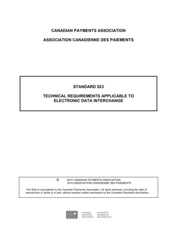
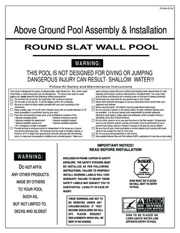
Summary of MGWA Finances1999 Board of DirectorsMembership Dues 9,490.00Interest Income 776.77Product Sales and ExpensesGuidebook, Mug, T’s 106.94Mailing List 25.00 15.60 9.40AdministrationPostage, SuppliesFinancial, Tax AccountingPost OfficeCorrespondanceBoard MeetingsDatabase MaintenanceMember ServicesNewsletter 1,674.00Directory 1,203.00Member CorrespondancePublic ServiceScholarships 461.OOWeb PageProgram ExpensesSpring Conference 7,792.00Fall Field Trip 3565.00Fall Conference 2,390.00 27,483.71Totals 1998Prepared by 1998 Treasurer Paul Bulger 1,326.39 8,163.61 776.77 20.40 86.54 72.87 1,504.43 105.00 33.10 417.78 2,400.00( 72.87)( 1,504.43)( 105.00)( 33.10)( 417.78)( 2,400.00) 6,602.07 694.07 755.81( 4,928.07) 508.93( 755.81) 900.00 883.42( 439.00)( 883.42) 4,916.31 3,890.03 1,315.64 2,875.69( 325.03) 1,074.36 25,852.92 1,630.791998 Income 27,463Fall Conference9%Spring Conference28%MembershipDues1998 ExpensesFall Field Trip4% 25,833Fall ConferenceMembership5%DuesSpring ConferenceAdministration21%IDirectory3%MGWA Newsletter, March I999Newsletter3GW.L”1”PresidentJim sident-ElectJim LundyMinnesota Pollution state.mn.usSecretary/MembershipJan FalteisekMinnesota state.mn.usTreasurerLee TrottaU.S. er.comEditorTom ClarkMinnesota Pollution a.state.mn.usAdvertisingManagerLeigh HarrodMetropolitan cholarship2%Past PresidentPaula BergerEnvironmental Strategies Corp.(612)343-0510FAX (612)343-0506pberger@escmn.comBusiness Management &PublicationsDr. Jeanette LeeteWatershed Research, Inc.(651)426-8795FAX (651)426-5449jennie-leete@msn.com@Minnesota Ground WaterAssociation. ISSN: 1098-0504Material in this publication maybe reprinted if appropriate creditis given. Views expressed in thispublication do not necessarily reflect official MGWA policy unlessexpressly stated as such.3
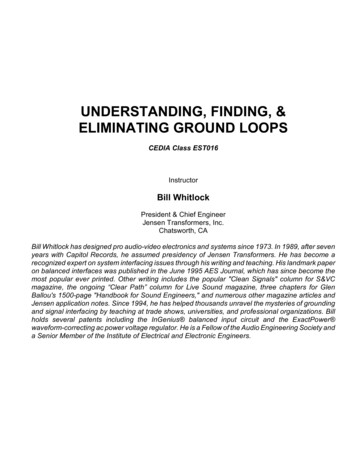
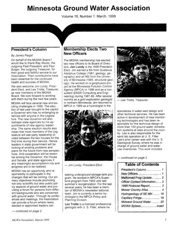
Mower County GeologicAtlas, Part AJohn H. Mossler, MinnesotaGeological SurveyQuaternary Geologic MappingAlthough Quaternary sediments arenot extensively exploited for groundwater in Mower County, their composition and distribution are importantbecause they influence the sensitivityof underlying bedrock aquifers to contamination. Where karsted carbonateaquifers are shallower than 50 feetbelow land surface, as they are inmany places throughout MowerCounty and much of surroundingcounties, they can no longer be usedfor potable water supplies because ofcontamination by human activities.The pre-late-Wisconsinanglacial driftis divided into three tills and affiliatedunits of stratified sediment that canbe correlated on the basis of till texture, color, and sand lithology withequivalent tills that are present innorth-central Minnesota (Meyer,1986). The deposits of stratified sediment (sand, gravel, and finer sediment) tend to lie at the base of thetills and, with paleosols that formed atthe tops of the tills, aid in distinguishing units. During each Quaternaryglaciation, the Laurentide ice sheetflowed into Minnesota from two majorsource areas: the Labrador sector ofnortheastern Canada and the Keewatin sector of northwestern Canada(Fig. 2). The flow paths of the icefrom these centers crossed differentrock types, resulting in different sediment compositions and textures forthe resulting glacial tills (Table 1).The pre-lllinoian tills of Mower Countycame from both the northeasterly Labrador and northwesterly Keewatinsectors (Fig. 2) and are of Rainy andWinnipeg provenance (Table 1). Superior-provenance till, which containsa suite of red volcanic and detritalrock fragments, is found in only a fewsmall exposures and is not listed inTable 1.IntroductionThe Mower County Geologic Atlas(Part A) was published by the Minnesota Geological Survey in June 1998.The atlas contains 1: 1:00,000-scalemaps showing the data base, bedrock and Surficial geology, depth tobedrock, bedrock topography, subsurface stratigraphy, and geologic resources. A Report of InvestigationsIt is necessary to discuss briefly the(J.H. Mossler, in prep.) containingmethodology used by the authors ofsupplementary text to Part A of the atthe Surficial map (Meyer and Knaelas will be published by the Survey inble, 1998) to distinguish Quaternarycoming months. Part B, depicting hyunits and map their Surficial distribudrogeology, karst features, and sensition before turning to the discussiontivity of ground water to pollution, willof the mapping methods used to mapbe published in mid-1999 by the Minthe subsurface distribution of Quaternesota Department of Natural Renary sediments. Except for its farsources, Division of Waters.western margin, glacial deposits thatBecause most members of theare probably pre-lllinoian in age (Fig.MGWA probably are already familiar1) cover Mower County. Therefore,with the county atlas program, I willmuch of the land surface lacks thenot dwell on features that are more orhummocky topography, abundantless standard for the series; rather, Ilakes and wetlands, and immaturewill discuss the following four newdrainage networks characteristic ofmapping techniques and interpretaland surfaces more recently glaciatedtions that were incorporated into theduring the late Wisconsinan. Beatlas.cause most of the county has low reLate-Wisconsinan Des Moines-lobe1. An innovative method was usedlief and few exposures of glacial till,ice advanced into Mower Countyto portray the subsurface distribunumerous soil borings were drilled. Infrom the west but halted its eastwardtion of unconsolidated Quaternaryaddition, five deep holes were coredadvance when it reached the valleymaterials. Hydrologists should findacross the northern half of theof the Cedar River, just inside thethis method particularly useful incounty, water-well cuttings, mostlycounty line. The late-Wisconsinanassessing the sensitivity of groundfrom the south part of the county, exNew Ulm Formation is of Ridingwater to pollution.amined and described, and texturalMountain provenance and came fromanalyses and lithic grain counts of the2. The Upper Carbonate Aquiferthe Keewatin sector (Table 1; Fig. 2).1-2-mm sand fraction conducted.System of the previous literatureThe soil survey of Mower Countywas subdivided into discrete aqui-continuedon page 6aided the delineation of Surficial mapfers separated by thin confininglayers.units (Carlson, 1989).3. The depth and oriTABLE 1. Characteristicsof mapped glacial deposits in Mower County, Minnesota.entation of buried[[Modified from Meyer and Knaeble (1998).]bedrock valleys wasBrowerville & ElmdaleRose CreekNew UlmFORMATIONdetermined using aRainyPROVENANCE.Riding Mountain . Winnipeg .combined gravityTILL TEXTURE .Loamy to sandy. . Loamy to clayey . Loamy to sandygeologic method.COLOR4. Karst landscapesYellow brown to olive brown . Yellow brown . Yellow brown to brownOxidrzed .Unoxidized. .Gray .Gray to dark gray. . Green gray to grayand associatedground-water uslyCretaceous carbonate . Rare .Rare to common . Absent to rareUncommon to common . Uncommon to commondocumented in thePaleozoic carbonate . Common .Dark-gray to gray-green rocks . Uncommon to common . Uncommon to common . Commoncounty-wereidentiRed felsite and sandstone . Rare to uncommon . Absent to rare . Rarefied and defined.Uncommon to common . Absent to rare . AbsentGray shale .MGWA Newsletter, March 1999
,:Dexterd’ii’1‘ I :*,, ’ ,: ’, ,,, , P”’ElktpnTaopix : “,/II ,, I, I, “ I// A II‘htw, /10 Miles510 KIlometersEXPLANATIONHOLOCENE AND PLEISTOCENE (LATE WISCONSINAN)/I,I’Floodplaindeposits& New Ulm Fm.--RidingMountain provenance.Loam to sandy loamtextured till; sand and gravel outwash; loamyto sandy alluvium; and minor eolian sand.PLEISTOCENE (PRE-WISCONSINAN)Browerville,Rose Creek, and Elmdale fms.,undividedWinnipeg, Rainy, and Winnipegprovenance, respectively. Loamy, clayey, andsandy till; clay; paleosol at top of each fm.Some sand, gravel, and silt beds, mostly atbottom of individual units.CRETACEOUS, DEVONIAN, ORDOVICIANBedrock and saprolith,undivided-Generallylimestone or dolostone; less commonly, shale,siltstone, sandstone, or conglomerate. Bedrockis within 10 feet of land surface, generallyweathered to saprolith in upper 5 feet.Figure 1. Simplified Surficial geology of Mower County. Modified from Meyer and Knaeble (1998).-MGWA Newsletter, March I999continued on next page
ProvenanceTABLE 2. Classificationof Quaternary subsurface map unitsby presence, order, and thickness of till units and sand beds.[Modifiedfrom Meyer and MosslerTILLNew UlmBrowervilleRose CreekElmdaleSAND BED(S)(1998);leader(--), not applicable.]NBREI:re-----G--4Figure 2. The maximum extent of the DesMoines lobe and related ice advances inMinnesota, and the source area of glacialsediment deposited in Mower County. Modifiedfrom Meyer and Knaeble (I 998).Line-bounded, lettered units representa composite thickness and stratigraphicorder of tills and sand beds from thesurface downward (see Table 2)BlLetteredNunit, bounded by black lines, indicates:uppermost till is New Ulm, and it is more than IO ft thick,next lower till is Rose Creek, and it is more than 10 ft thick, andlowest till is Elmdale, and it is more than 10 ft thick.REGLetterednrEG as the last letter indicates that there are no more tills in the sequence,and that sand beds thicker than 10 ft are present within thevertical section.I-unit, bounded by black lines, indicates:uppermost till is New Ulm, and it is patchy or less than 20 ft thick,next lower till is Rose Creek, and it is patchy or less than 20 ft thick, andlowest till is Elmdale, and it is thicker than 10 ft.The absence of a G as the last letter indicates that sand beds are unlikelyto be present in the sequence.-l-Figure 3. Explanation of line-bounded, lettered units as used in the Quaternary Subsurface Stratigraphymap of Mower County. Modified from Meyer and Mossler (1998).-continued on next pageMGWA Newsletter, March I999
Mower County Atlas, cont.Subsurface StratigraphyPlateThe Subsurface Stratigraphy plate(Meyer and Mossler, 1998) incorporates several innovations not includedon similar plates in the past, some ofwhich cannot be reproduced for thisarticle. For example, the plate has sixcross sections that show the suc
Advertising Manager Leigh Harrod Metropolitan Council (651)602-8085 mn-homebase@worldnet.att.net Business Management & Publications Dr. Jeanette Leete Watershed Research, Inc. (651)426-8795 FAX (651)426-5449 jennie-leete@msn.com @Minnesota Ground Water Association