Transcription
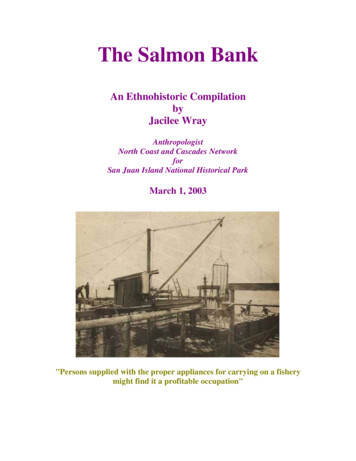
The Salmon BankAn Ethnohistoric CompilationbyJacilee WrayAnthropologistNorth Coast and Cascades NetworkforSan Juan Island National Historical ParkMarch 1, 2003"Persons supplied with the proper appliances for carrying on a fisherymight find it a profitable occupation"
"At night all the Purseine boats used to anchor in Griffin Bayand some of the men would come up to the house and sing.Uncle George played the violin and Aunt Annie the piano.Uncle Frank called for the square dances."Caption on back of trap photo by Bill JaklePicnic below Boyce place 1938
A special thank you to Bill Jakle for sharing his incredible knowledge and photographs
Table of ContentsIntroductionSummary of Salmon Bank HistoryRegulationHow a Trap WorksReferencesBill Jakle Interview excerptsEtta Egeland Interview excerptsBill Mason and Babe Jewett interview excerptsBill and Fran Chevalier interview excerptsAPPENDICESAppendix A - Trap InventoryAppendix B - Daily CatchAppendix C- Duwamish et al. Vs. U.S.Photos from Whatcom County Historical SocietyPacific Salmon Fisheries by John Cobb (1921)The Salmon Industry by P.A.F.Ecological Succession in the San Juan IslandsRegulationsMorisset, et al. Treaty Indian Commercial FishingSan Juan Island T Sheet Maps1210111417 Blue Tab566062Clear Tab677273Green TabYellow TabClear TabBlue TabGreen TabOrange TabYellow Tab
IntroductionOver the past three years, the following information has been collected and compiled byJacilee Wray, anthropologist at Olympic National Park. Included here are excerpts frominterviews with several long-time residents of San Juan Island who have specific knowledgeabout the Salmon Bank off of South Beach at San Juan Island National Historical Park.Archival research was also conducted at the Center for Pacific Northwest Studies inBellingham, as well as collecting and reviewing published accounts, and locating andscanning historic photos. This information has been compiled so that park staff canunderstand the cultural importance of the Salmon Bank and identify further research.1
Summary of Salmon Bank HistorySan Juan Island emerged from the last glacial period around 13,000 years ago. The greatmoraines left behind by the glacial ice formed a submerged ridge, known as the Salmon Bank(Stein 1994:11-1). If people occupied the island soon after the glacial ice retreated,archeologists have yet to discover their remains. Perhaps because the ocean level has risensince that time, leaving archeological evidence submerged. Archeologists do know that peopleinhabited the island about 5,000 years ago, around the same time that important resources likethe western red cedar and the Pacific salmon stabilized (Bergland 1988:38). Archeologicalevidence of habitation and harvesting of marine resources increases by 2,500 years ago. Thepeople living at South Beach may have been weaving fiber for reef nets with the whale bonewhorl found within the Maritime Phase (2500 to 1500 BP) of the Cattle Point site by ArdenKing in 1946 (King 1950; Stein 2000:49). Arden King states that the Salmon Bank"constituted a powerful factor in the regular occupation of the Cattle Point site" (King1950:3).In historic times we know the Indian reef net fishery was well established off the islands andin 1850, James Douglas, the manager of the Hudson Bay's installation at Fort Victoria,decided to explore the potential for trade with the Indian fisherman of San Juan Island."William McDonald was sent to the southern tip of the island where the natives had set upextensive systems of reef nets on the shoals" (Bailey-Cummings 1987:21-22). A Hudson'sBay fishing camp was located at what is known today as Grandma's Cove, in either 1850 or1851. Wayne Suttles (1998:38) conducted a study for the NPS on historic fishing locations,and concluded that the location of the HBC salmon fishery is uncertain, as there are reports2
that it could have been at Eagle Point or Fish Creek, as well as Grandma's Cove. It appearsfrom Charles John Griffin's 1854 journal that the HBC moved its fishery station that winter.Griffin notes on April 8th that a band of Klallam are at "my old encampment" waiting for thesalmon fishery. On July 12th Griffin reports that the station [perhaps the new fishing station]is at the small prairie at the end of Cowitchen Road1. This is a different location from thesheep encampment, which he identifies at the oak prairie. On September 3rd Griffin sets out torelocate to a winter station and finds "no place more convenient in every way & none so welladapted for a winter station as the small prairie before coming to the Bridge." On September18th they "commence" to open the road from the shore of "Grande Bay" to the proposedwinter station and on November 27th the "Men & Inds" are all at the new station (Griffin1854).There were many Indian camps in the area, as Griffin sent a notice to all Indian encampmentsat the different fisheries on July 13, 1854. He mentions the Klallam commencing their fishingin two journal entries (6/3/54 & 6/6/54). There is also a reference to the Klallam living2 on theisland in April of 1858 that relates to a request for American protection from their marauding(Flaggaret 1859). Griffin traded salmon with the Cowichan (8/26/54), Songhees (10/5/54),and Saanich (11/13/54), but the only reference found in Griffin's journal to the Indians fishingspecifically for the HBC fishery is on June 9, 1854 noting Cowitchen Jack fishing for theestablishment. According to a book by Bailey-Cummings and Cummings (1987:21-2) theEnglish paid the Indians one blanket (worth about 4) for every 60 fish caught for the HBCoperation. At McDonald's fishery camp workers salted 2,000 to 3,000 barrels of salmon perseason. Presumably, the salmon was supplied by the Indians who had reef nets around SanJuan Island west of Pile Point, at Deadman Bay, Andrews Bay, and Mitchell Bay; and OpenBay on Henry Island (Bailey-Cummings 1987:22).There is considerable documentation of Native groups who had settlements, mostly seasonal,on San Juan Island in historic times.In an Elwha Klallam interview conducted for Olympic National Park, Rosalie Brandt said herparents lived on San Juan Island on the "state side," which might mean the American side.Rosalie's sister was born on the island on September 11, 1896. Her mother, JosephineSampson was from Saanich and her father Andrew Thomas was Lummi. They lived atVictoria Harbor and would come across to camp and dig clams on the island, where they "meta lot of Indians" (Brandt 1991).In the first U.S. land claim testimony, Duwamish, et al. vs. U.S., depositions were taken fromSan Juan Island Indian residents, describing Indian village locations that they remembered intheir lifetime, as well as changes in fish trapping3 (Appendix D). The following summaryreflects their testimony and includes the claimant's name and age in 1927.1"Probably the town site of Friday Harbor, as Boyd Pratt has deduced from descriptions and map contained inHunter Miller, San Juan Archipelago, UW, 1943, Wyndam Press, Vermont, in collection of SAJH"(Correspondence Mike Vouri 4/7/03).2George Gibbs reported for the Northwest Boundary Survey that the Clallams occupied "a part of San Juan";while "the whole inside, or north eastern part of San Juan, formerly belonged to a tribe kindred to the Lummies(sic) and now extinct." Gibbs suggested that the valuable fisheries would make this an "admirable" reservation inthe future if it was "desirable" to remove these "tribes from the main" (Gibbs 1858).3In 1880 there were 382 Indians in San Juan County and a white population of 948 (Hayner 1929:83).3
F.D. Sexton, age 74, remembered events from 1859. He lived at Kanaka Bay and knew ofIndians living on the Larson place in quite a few cedar plank and bark houses. Mr. Sexton saidthere was a "burying ground over there at our place," where they buried their dead in canoeson a little island and that when the tide was out you could walk across to it. In 1927 therewere still several graves that could be seen on the banks. Indian houses were also locatedalong the beach and at a place where "they used to come over on the side-from the other sideto live and fish" [South Beach] (US 1927:428).Alice Lighheart, age 56, remembered villages at Kanaka Bay and Mitchell Bay.Jim Walker, age 69, said there were Indian houses at Kanaka Bay, including one big houseand several smaller houses and there was one Indian house at Argyle (US 1927:455-6).Cecelia Knowlsen, age 95, remembered Captain George, who they called Queana and ChiefSeattlak. He lived in a house down by the Hudson Bay Post. The house was made of mat andboards and was located on the bank, close to the beach (US 1927:456-9).John Dougherty, age 74, had lived on the island since 1865 and discussed the Indians fishingin the early days, until the white people put up fish traps at the locations where the Indiansfished. When asked how many traps there were at this locality, he said there were quite a fewof them, "mostly on the west side of the island" (US 1927:443).Mr. Dougherty mentioned Indian houses he remembered in his early years: one up onMitchell Bay, two or three down at the south end of the island, and "every little place used tohave shacks of their own," all around the island. "Right across here they had one, on thisreservation, on the beach there. Up here at the north there was one, besides Mitchells Bay.They didn't live on Griffin's Bay, they lived on the beach [South Beach] then and also down atwhat they call the south end, that is, on Hobbs Place4" (US 1927:442-4).Stephen Gross, age 50, a San Juan Indian who had been fishing for 30 years in 1927, told theinterviewers that 20 years ago there were 25 fish traps, while only 15 in 1927. In the earlydays the fish packing companies took up the old Indian fishing locations and drove theIndians away (US 1927:449-50).Jane Williams, age 66, remembered villages on the north end of Roche Harbor, at AmericanCamp, and down at the light station "was a little village there." She remembers buildings stillhabitable at Mitchell Bay, and at the wireless station at Cattle Point she saw houses that hadtheir extant corner posts and roofing [presumably not wireless station built for WWI].Mrs. Williams spoke of changes in salmon fishing. She said that the white people built theirtraps at the old locations where the Indians used to take their fish, and that the Indians had togo somewhere else to "get their living" as the white people drove them off and took theirplace. "They had to go somewheres, you know" (US 1927:437).41860 map shows Hubbs near Cattle Point. Paul Hubbs was a customs official who had several wives over time,including several Indian girls (Bailey-Cummings 1987:63-64).4
Caroline Ewing, age 78, remembered a "big reservation" at Hobbs Point, and one at "thefort," in early times. Also "one below Peter Larson, and one below our place. JimmyFleming's place [Map], and one at Roach (sic) Harbor and scattered all along the beach thatway, villages all through" (US 1927:439). She was asked if there were many Indians whenshe was a girl, and she replied "Oh, I say there was," and that they had their permanentvillages all around. She remembered Captain George, who was "chief" on one side of theisland," somewhere on Bald Hill. She said, she couldn't count all the villages, but "this littlevillage" had 30 or 40 houses, and a big fish-drying building. She was asked if the housebelonged to the people that lived in them and she said that they belonged to the tribe. "Onewill go and another will walk right in" (US 1927:438-442).Caroline also responded to questions about fishing. She said it used to be thick with fish andthat she had seen the Indians dry their fish, "you know, and it would stand so high, just likeyou would cut cordwood and cord it up, it was so thick. They just took out what they wantedand just threw the others away, but of course there was no white folks around to get the fish."Back then it was "nothing but the Indians." Now the fish are pretty scarce. When asked why,she replied that "if it wasn't for the traps of the whites--they caught them all away." They havetraps all over the island at different places (US 1927:440-441).With the numerous Indian fisheries to supply the HBC operation, the fact that the fishery had"fallen off" by 1859 is surprising (Gibbs 1859). Dr. C.B.R. Kennerly notes the end of thefishery in his 1860 report:In the vicinity of the southern end of the island are perhaps the best fishing grounds onPuget Sound. Great quantities of halibut, codfish, and salmon are taken by thenumerous tribes of Indians who at the proper season resort to this vicinity for thepurpose of fishing. The Hudson's Bay Company were formerly in the habit of puttingup at this place from two to three thousand barrels of salmon alone which were boughtfrom the natives. Persons supplied with the proper appliances for carrying on a fisherymight find it a profitable occupation (Kennerly 1860).Indian reef-net fishermen and settler families fishing with net or pole were probably the maintypes of fisheries at the Salmon Bank until the late 1880s when non-Indians began to harvestsalmon with fish traps. The first fish trap on Puget Sound is documented in about 1880 atPoint Roberts, for which the owner used the Indian reef-nets as a model, as the "leadsduplicated that of the Indians" (Cobb 1930:483, 486). The fish traps were able to capturesockeye, which previously had to be caught in sheltered areas along the shore with seine andgill net (Rathburn 1900:340). Around 1892, Deblin5, who started the cannery at FridayHarbor, had a trap outside of Fisherman's Bay, Lopez Island (Troxell Mason 1991:165).The trap was lauded as the "most efficient means of catching sockeye salmon," however ithad the adverse effect of limiting access and productivity of tribal reef-net locations (Radke2002:12). The impact on the reef-net is reflected in that by 1909 only five Indian reef-netswere still in use (Cobb 1930:487).5Cobb says the name was A.E. Devlin, who came from the Columbia River (Cobb 1921:19).5
Washington state law required traps to be physically removed from the water during a part ofeach year beginning in 1892 (Morisset, et. al 1978). This meant that at the end of every seasonengineers had to precisely survey the pilings before removal, to ensure they would be placedin their exact (licensed) location the next spring (Mason Troxell 1990). The depth, length, andspacing requirements were set by the state, as were restrictions on acquisition andabandonment of sites. The mesh had to be greater than three inches and the lead shorter than2,500 feet. The end passageway requirement was at least 600 feet and the lateral passagewayat least 2400 feet between nets [Ballinger's Annotated Codes and Statutes of Washington, Sec.3349, 3351, 3353, (1897)]. In 1898 and 1899 many fish trap locations "changed hands" as thebig companies began purchasing trap locations (Cobb 1930:483). Section 3349 ofWashington Statute decreed that no one person or corporation could own more than three trapsites. To circumvent the law, companies like PAF formed fish trap corporations. This is thereason for the diversity of names for trap licenses on San Juan Island as seen in Appendix A.The cannery at Friday Harbor began operations in 1894 (Cobb 1921:19;Radke 2002:16). InMarch of 1899 the Pacific American Fisheries (PAF) purchased the Island Packing Companyat Friday Harbor and it was renamed Friday Harbor Packing Company. This cannery was animportant operation for the PAF until their corporate end in 1965 (Radke 2002:23-4). Thecannery workers may have consisted of many local people, but they also employees Chineselaborers, as correspondence from 1901 refers to the Chinese working at the cannery and acannery diagram shows "China house" [Chinese quarters] (PAF 1901b). 1903 correspondenceindicates that there were also Japanese workers at the cannery, but they "got rid of" them(PAF 1903b).DIAGRAMS OF FRIDAY HARBOR CANNERY6
In 1898 the PAF owned fifty fish traps and packed 70% of the Puget Sound6 sockeyes (Radke2002:24). By 1901 private owners had sold almost all of the fish trap locations to the bigcompanies, some of the best locations selling for over 100,000. These locations becamepermanent fixtures of the cannery business, and were filed upon, surveyed, licensed, andworked on a specific schedule (Shield 1918:65). Sometimes dummy traps or non-workingtraps were set up to retain a licensed location. Crews would stage a catch at these dummytraps to comply with the law that required they be used within a seven year time period(Thorstenson 1995).The sockeye salmon industry was bountiful, its biggest years were 1905 and 1909 (Radke2002:95), but the best the PAF ever packed was 450,000 cases in 1913 (Radke 2002:160).PAF records at the Center for Pacific Northwest Studies provide catch records and someinsight into the operation of the PAF Salmon Bank camp, operated by Friday Harbor PackingCo. and located below the spring at South Beach (See Map). James Burke was thesuperintendent of both the cannery and the trap camp at South Beach in 1900. On July 9, 1900the cannery received 2,000 fish, resulting in 178 cases of sockeye, 35 cases of red spring and8 cases of white spring (PAF 1900)The following list comprises the grades of canned salmon with brands owned or controlled byDeming and Gould Co. or Pacific American Fisheries (Mitchell 1920:30-31).Brands ofPuget SoundSockeye:Brands ofPuget SoundChinook:Brands ofPuget SoundCohoes:Brands of PinksBrands ofChum6Puget Sound is defined in the statute as "that portion of the tide waters emptying into the Straits of Juan deFuca, and the bays, inlets, streams, and estuaries thereof." [Sec 7381 (1897)].7
Blue JayBow KnotEmpressGlenwoodHindooJungleKenmoreKey CityOakleafPride of OceanRed PoppyRed RoverRed TopSportUwantaWar EagleWarriorSockeye [Red,Blueback, orQuinault]The most plentifulof all the species ofsalmon.Packed in July andAugust.Great NorthernRoyal FisherAutumnChicCircle SCycleD.A.REasterModocRockSouthlandWhite RockCloveCorsairJapKing BirdMinnehaha7-11ShellStorkTerrapinAukHarbor LightHumpty DumptyNauticalNileRacelandChinook [Spring,King, Tyee,Quinnat] Packed inspring andsummer.Cohoe [MediumRed, Silversides]Packed in OctoberHumpback or PinkSalmonPacked in Augustand SeptemberChum [Calico,Keta, or DogSalmon]Packed inNovemberThere was often a discrepancy between the count of salmon at the trap site and the count atthe cannery. On July 24, 1900 John Berg, camp manager, counted 7200 sockeye and 700spring salmon at the trap, whereas the cannery counted 5790 sockeye and 540 spring.Superintendent Burke believed the cannery count the correct one because they were counted"into the tub" (PAF 1900a,b).The camp at South Beach obtained their water from at least three locations between 1900 and1903. In 1900 the PAF commissioned the steamer Councilman to tow a filled water scow tothe Salmon Bank and the steamer Michigan brought the empty scow back (PAF 1900).William Jakle, Sr., operated the Michigan around 1900. In 1901 [Edward] Warbass presentedPAF with "a bill for water" (PAF 1901a) and in 1902 payment of rental for the water right atthe spring at Salmon Bank camp was made to Eliza Jakle for 50.00 (PAF 1902). In 1903 theBellingham cannery requested that the San Juan Island manager "buy us a ton of old potatoesin good condition for use over here? Potatoes are very short on the Bay. New potatoes areworth about 2 cents per pound . If you can secure a ton for us, please ship them as soon aspossible, and try and arrange to have the steamer land at our Commissary dock (PAF 1903a).8
South Beach, Courtesy Whatcom County Museum (WCM 7298)South Beach views, Courtesy of Bill Jakle9
Frank McLain was the cook at the camp in 1899. Receipts show that milk was being furnishedto the pile and steamer drivers by Mrs. George Heidenreich, Bill Jakle's maternalgrandmother. Mrs. Heidenreich indic
In 1880 there were 382 Indians in San Juan County and a white population of 948 (Hayner 1929:83). 4. . boards and was located on the bank, close to the beach (US 1927:456-9). John Dougherty, age 74, had lived o