Transcription
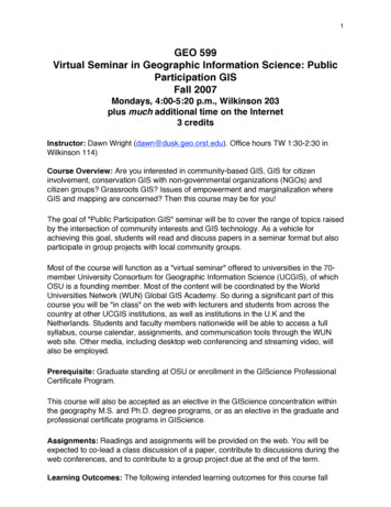
1GEO 599Virtual Seminar in Geographic Information Science: PublicParticipation GISFall 2007Mondays, 4:00-5:20 p.m., Wilkinson 203plus much additional time on the Internet3 creditsInstructor: Dawn Wright (dawn@dusk.geo.orst.edu). Office hours TW 1:30-2:30 inWilkinson 114)Course Overview: Are you interested in community-based GIS, GIS for citizeninvolvement, conservation GIS with non-governmental organizations (NGOs) andcitizen groups? Grassroots GIS? Issues of empowerment and marginalization whereGIS and mapping are concerned? Then this course may be for you!The goal of "Public Participation GIS" seminar will be to cover the range of topics raisedby the intersection of community interests and GIS technology. As a vehicle forachieving this goal, students will read and discuss papers in a seminar format but alsoparticipate in group projects with local community groups.Most of the course will function as a "virtual seminar" offered to universities in the 70member University Consortium for Geographic Information Science (UCGIS), of whichOSU is a founding member. Most of the content will be coordinated by the WorldUniversities Network (WUN) Global GIS Academy. So during a significant part of thiscourse you will be "in class" on the web with lecturers and students from across thecountry at other UCGIS institutions, as well as institutions in the U.K and theNetherlands. Students and faculty members nationwide will be able to access a fullsyllabus, course calendar, assignments, and communication tools through the WUNweb site. Other media, including desktop web conferencing and streaming video, willalso be employed.Prerequisite: Graduate standing at OSU or enrollment in the GIScience ProfessionalCertificate Program.This course will also be accepted as an elective in the GIScience concentration withinthe geography M.S. and Ph.D. degree programs, or as an elective in the graduate andprofessional certificate programs in GIScience.Assignments: Readings and assignments will be provided on the web. You will beexpected to co-lead a class discussion of a paper, contribute to discussions during theweb conferences, and to contribute to a group project due at the end of the term.Learning Outcomes: The following intended learning outcomes for this course fall
2under various categories in the UCGIS GIS & T Body of Knowledge: GS3 Public use of geospatial informationGS3-1 Major uses of geospatial information and of land informationStudentsshould be able to describe the common uses of geospatial information ingovernance, including ethical, security, aesthetic/scientific, and managementuses.GS3-3 Public participation in legislating and administeringStudents should beable to differentiate grassroots participation and community-initiated GIS fromthe broader field of participatory GIS. They should be able to defend or refute thecontention that grassroots participation and community-initiated GIS accentuatethe development of alternative ways of conceptualizing geographic informationand the adaptation of new geographic technologiesGS3-4 Individual, group, and societal perspectivesBy way of group discussionsand a term project of their choice, students should be able to:o Propose a strategy for soliciting “local knowledge” about a given resourcemanagement issue.o Describe the problem of distilling the spatial aspect of local knowledge.o Explain how, and how well, local knowledge may be represented in a GIS.o Exemplify a case in which local knowledge played a role in land use,coastal/ocean use, resource allocation, or other planning decisions.o Speculate on how local knowledge concerning a decision to locate acontroversial land use (e.g., retail megastore, strip mall, strip mine, orhalfway house) may vary by community.Explain how citizen participation improves local government planning processesand outcomes.SCHEDULE:September 24Introduction to CourseOctober 1Review and Discussion ofHarris, T. and Weiner, D., 1998. Empowerment, marginalization, and "communityintegrated" GIS. Cartog. Geog. Inf. Sys., 25(2): 67-76.Ghose, R., 2001. Use of information technology for community empowerment:Transforming geographical information systems into community information systems.Transactions in GIS, 5: 141-163.October 8Review and Discussion ofGhose, R. and S. Elwood, 2003. Public participation GIS and local political context:Propositions and research directions. URISA Journal 15(APA II): 17-24.Sieber, R., 2006. Public participation geographic information systems: A literature
3review and framework. AAG Annals, 96(3): 491-507.October 15Review and Discussion ofElwood, S., 2006. Beyond cooptation or resistance: Urban spatial politics, communityorganizations, and GIS-based spatial narratives. AAG Annals, 96(2): 323-341.Elwood, S., 2007. Grassroots groups as stakeholders in spatial data infrastructures:challenges and opportunities for local data development and sharing. InternationalJournal of Geographic Information Science, DOI: 10.1080/13658810701348971: 1-20.October 17 – WUN online activities begin! See the following pages.
4Public ParticipationGeographic Information SystemsJoint Worldwide Universities Network/RGS (with IBG)Quantitative Methods Research Group e-seminars, Fall 2007
5Introduction: Aims and ObjectivesThe WUN Global GIS Academy’s 2007 seminar series is intended to reflect this growing importance ofpublic participation GIS. As usual it will enable participants to access contributions from some of thebest-known names in the field, but in addition we hope and expect that provision of an internationaldimension to the discussions will add greatly to the experience.Following the seminar series should enable participants to: follow current literature in the field;compare and contrast participatory GIS, public participation GIS, Internet GIS and Web GISinformation technologies;understand the interplay between GIScience and GISystems research;understand the advantages and disadvantages of different research approaches for assessingPPGIS use.Who can participateThe seminar is open to faculty and students in universities that are part of the WUN, together withmembers of the Quantitative Methods Research and GIScience Groups of the Royal Geographical Society(with IBG) and other interested parties. Although the series carries no activities for which a formalassessment is appropriate, our hope is that graduate student classes, in particular, will build on it bycreating some formal, assessed activity that enables the series to be ‘hard wired’ into their researchtraining programs. Possible activities might be completion of an individual essay based on some or all ofthe presented materials,Seminar EnvironmentBuilding on its successful use in our 2005 and 2006 seminar series, the seminars will use theMarratech platform, which is an extended desk top video and audio-conferencing environment (seewww.marratech.com for details). This platform enables a moderately sized client to be downloaded andused with Windows , Linux and Mac-OS systems. Provided broadband access is available, participantscan use this system with a simple headset/webcam from home, or via a pre-arranged video suite at thehome university, which is what we would recommend for entire classes of graduate students. If youintend to set up such a suite, please note that institutional firewalls can generate problems in using theclient, but these are not insurmountable.List of dates & topicsAll seminars will commence at 1600 UK time, initially BST then GMT (8:00a.m. Pacific Time). Please check carefully that you have the correct localtime.Lec#1DateTopicPresenteremailsWed. 17thOctPPGIS: Who are the'Public' andWhat are They'Participating' In?Robin Smith(Sheffield) &Richard .uk,robin.smith@sheffield.ac.uk
6Lec#23DateTopicPresenteremailsMon. 22ndOctWed. 24thOctClass Discussion &Group Project WorkDesign Strategies forParticipatoryGIS/SDSSPiotr Jankowskipiotr@geography.sdsu.eduMon. 29thOctMon. 5th NovClass Discussion &Group Project WorkClass Discussion &Group Project WorkUnpacking theComplexities of PPGISRina Ghose(Wisconsin atMilwaukee)rghose@uwm.eduSarah Elwoodselwood@u.washington.eduWed. 7thNovMon. 12thNovWed. 14thNovClass Discussion &Group Project WorkCritical GIS: Methodsfor Exploring PGIS andPPGIS UseMon. 19thNovMon. 26thNovClass Discussion &Group Project WorkOSU Students!5Wed. 28thNovPresentations ofGroup ProjectsSteve Carver6Wed.5th DecQuantifying thequalitative: capturingenvironmentalperception inspace/place problemsReflections on andDirections for PPGISResearch4s.j.carver@leeds.ac.ukTim Nyergesnyerges@u.washington.eduTo view the lectures in real-time and participateOn the day of the lecture, at 7:45 am (3.45pm, UK local time), please go tohttp://www.wun.ac.uk/ggisa/seminars.html to launch and enter the Marratech virtual seminar room.The seminars commence at 8 am local time (4pm UK time). Full instructions on how to access them arealso available at the website http://www.wun.ac.uk/ggisa/seminars.html.We strongly recommend that you ‘enter’ the virtual seminar room well in advance of the advertisedstart.The archiveThe 2005 seminars, on Hot Topics in GISc and the 2006 seminars on Spatio-temporal modeling in GISchave been archived at the WUN GGISA website:
7http://www.wun.ac.uk/ggisa/seminars.htmlThe precise form of any one session archive depends upon what we were able to acquire, ranging fromPowerPoint or PDF files of the materials used through to complete recordings of the session that canbe viewed off line using the Marratech client. Instructions on how to do this are on the same website.Dave Unwin (WUN)Tim Nyerges (University of Washington)
Virtual Seminar in Geographic Information Science: Public Participation GIS Fall 2007 Mondays, 4:00-5:20 p.m., Wilkinson 203 plus much additional time on the Internet 3 credits Instructor: Dawn Wright (dawn@dusk.geo.orst.edu). Office hours TW 1:30-2:30 in Wilkinson 114) Course Overview: Are you interested in community-bas