Transcription
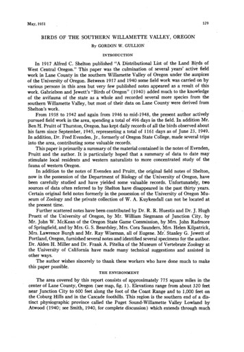
May, 1951BIRDS129OF THESOUTHERNWILLAMETTEBy GORDONVALLEY,OREGONW. GULLIONINTRODUCTIONIn 1917 Alfred C. Shelton published “.4 Distributional List of the Land Birds ofWest Central Oregon.” This paper was the culmination of several years’ active fieldwork in Lane County in the southern Willamette Valley of Oregon under the auspicesof the University of Oregon. Between 1917 and 1940 some field work was carried on byvarious persons in this area but very few published notes appeared as a result of thiswork. Gabrielson and Jewett’s “Birds of Oregon” (1940) added much to the knowledgeof the avifauna of the state as a whole and recorded several more species from thesouthern Willamette Valley, but most of their data on Lane County were derived fromShelton’s work.From 1938 to 1942 and again from 1946 to mid-1948, the present author activelypursued field work in the area, spending a total of 496 days in the field. In addition Mr.Ben H. Pruitt of Thurston, Oregon, has kept daily records of all the birds observed abouthis farm since September, 1945, representing a total of 1161 days as of June 23, 1949.In addition, Dr. Fred Evenden, Jr., formerly of Oregon State College, made several tripsinto the area, contributing some valuable records.This paper is primarily a summary of the material contained in the notes of Evenden,Pruitt and the author. It is particularly hoped that a summary of data to date maystimulate local residents and western naturalists to more concentrated study of thefauna of western Oregon.In addition to the notes of Evenden and Pruitt, the original field notes of Shelton,now in the possessionof the Department of Biology of the University of Oregon, havebeen carefully studied and have yielded some valuable records. Unfortunately, twosources of data often referred to by Shelton have disappeared in the past thirty years.Certain original field notes formerly in the possessionof the University of Oregon Museum of Zoology and the private collection of W. A. Kuykendall can not be located atthe present time.Further scattered notes have been contributed by Dr. R. R. Huestis and Dr. J. HughPruett of the University of Oregon, by Mr. William Siegmann of Junction City, byMr. John W. McKean of the Oregon State Game Commission, by Mrs. John Radmoreof Springfield, and by Mrs:G. S. Beardsley, Mrs. Cora Saunders, Mrs. Helen Kilpatrick,Mrs. Lawrence Burgh and Mr. Ray Wiseman, all of Eugene. Mr: Stanley G. Jewett ofPortland, Oregon, furnished several notes and identified several specimensfor the author.Dr. Alden H. Miller and Dr. Frank A. Pitelka of the Museum of Vertebrate Zoology atthe University of California have made many technical suggestions and assisted inother ways.The author wishes sincerely to thank these workers who have done much to makethis paper possible.THEENVIRONMENTThe area covered by this report consists of approximately 77.5 square miles in thecenter of Lane County, Oregon (see map, fig. 1). Elevations range from about 320 feetnear Junction City to 600 feet along the foot of the Coast Range and to 1,000 feet onthe Coburg Hills and in the Cascade foothills. This region is the southern end of a distinct physiographic province called the Puget Sound-Willamette Valley Lowland byAtwood (1940; see Smith, 1940, for complete discussion) which extends through much
130THESOUTHERN WIILANEI AMFTTFCONDORVol. 53VA,, I V(Fig. 1. Map of the southern WillametteValley, Lane County, Oregon.of western Oregon.and all of western Washington. In Oregon this trough is boundedon the seaward side of the Coast Range and on the interior by the Cascade Range.Moisture-laden, marine air massescrossa 2000-foot range before spilling into this regionand then come up against a 6000-foot range before moving farther inland.These physical features cause sufficient precipitation that all major streams in thearea flow with considerable volume throughout the year. Annual flooding in the past hasproduced a fairly level flood plain in the valley floor.A characteristic of this valley greatly affecting the flora and fauna is the naturallevee along the Willamette River. This feature causes numerous tributary streams toflow for considerable distances in the nature of “Yazoo” streams before they are able
May, 1951BIRDSOF SOUTHERNWILLAMETTEVALLEY131to join the major river (Smith, 1940). The area has many small marshes and scatteredflood plain and ox-bow lakes as a result of this. During much of the winter many squaremiles of the valley floor are covered with a few inches of water.Scattered throughout the valley are dome-shaped, basaltic buttes which vary fromsmall humps 20 or 30 feet high and a few hundred feet long to large domes severalhundreds of feet high and two or three miles long. The soil on these buttes is of shallowresidual nature with numerous rock outcroppings while the valley soils are generally oftransported origin.Two recentlyconstructed flood-control dams have locally altered the physical character of this area. The Cottage Grove Dam on the Coast Fork River south of CottageGrove holds a summer pool of 1158 surface acres and a winter pool of 293 surfaceacres. This lake, filled for the first time in 1943, is of minor importance from the standpoint of bird life because of its steep banks and deep water. However, the Fern RidgeDam near Alvadore has produced a major ecological association previously absent in thisarea. This dam, completed in 1941, holds a summer pool of 9360 surface acres and awinter pool of 1480 acres. From late August until early May about 7800 acres of softmud are available for wintering shore-birds. The 27 miles of summer shore line, mostlyin low grassy fields, provides nesting facilities for several speciesof birds.Atwood (1940) places this area in the range of the Marine West Coast element ofthe Humid Mesothermal Climates. It lies in the Csb climate of Kijppen, that is, theregion is humid, with a January mean temperature of more than 32 F. and a July meantemperature of less than 7 1 F.; there is a summer drouth with a 3: 1 or greater ratio ofJanuary mean precipitation to that of August (Hopson, 1935).Eugene has an annual average temperature of 52.3’F., with the average lowest temperature for the coldest six weeks at 34 F. and the average highest temperature for thehottest six weeks at 80 F. Minimum and maximum recorded temperatures have been-4” and 105 F. The growing season (killing frost to killing frost) averages 205 days,the prevailing wind direction is northwest, and the average annual precipitation is 37.88inches, with 6.7 inches being in the form of snow. The area has an average of 148 daysduring which 0.01 inches or more of precipitation falls; these days may be consideredas overcast. These averages represent periods of from 36 years (U. S. Weather Bureau,1930) to 40 years (Wells, 1941).The 2000-foot summit of the Coast Range between this valley and the Pacific Oceanleaves much of the area in a rain shadow. The western side of the valley has an annualrainfall of about 30 inches which increasestoward.the east to about 45 inches at Walterville (Detling, 1948). Cottage Grove has an average of 42.82 inches of rainfall annually.This variation in the amount of rainfall acrossthe valley results in a considerable variation in vegetation types. Although Peck (1941) believes the valley was originally covered by coniferous forest, it has been altered so much in historic times that climaxvegetation is scarce on the valley floor.The western and southern parts of the valley floor are covered by oak woodland,a subclimax association (Detling, 1948) consisting of Garry oak (Quercus garryana),black oak (Quercus kelloggii) , madrone (Arbutus menziesii) , poison oak (Rhus diversiloba), and wild rose (Rosa nutkana). In some areas along the north side of the Callapooya Hills there are nearly pure stands of black oak, whereas considerable numbersof yellow pines (Pinus ponderosu) are found in the Veneta and Elmira areas and afairly pure stand occurs in the Spencer Creek area.Farther east across the valley, where the soil is sandy or loamy and the rainfall alittle more abundant, the flora is somewhat more luxuriant. Along the Willamette and
132THECONDORVol. 53McKenzie rivers are extensive areas of black cottonwood (Pop&s trichocarpa) , interspersed with Oregon maple (Acer macrophyllum) , an occasional alder (Alnus rubra),cascara (Rhcmnus purshiana) and in some places numerous incense cedars (Libocedrusdecurrens) . The understory of this association consistsof nine-bark (Physocarpus capitutus), Indian peach (Osmaronia cerasiformis), western hazel (CoryZus californica) andwestern valley syringa (Philadelphus gordonianus) .On the better soils away from the streams a few extensive pure stands of the climaxDouglas fir (Pseudotsuga taxijulia), the lower montane forest of Detling (19 8) stillremain. 4 few grand firs (Abies grandis) are scattered through this forest while theunderstory consists of vine maple (Acer circinatum), Oregon grape (Berberis aquifolium), western flowering dogwood (Cornus nuttallii) and red-flowering currant (Ribessanguineurn) .On clay or adobe soils, especially in the Long Tom-Coyote Creek basin, are growthsof Oregon ash (Praxinus oregoncl), black hawthorn (Crataegus douglasi), western chokecherry (Prunus demissa)7 serviceberry (Amelanchier florida), snowberry (Symphoricarpos albus), wild rose and occasionally Garry oak. On the dry south sides of thebasaltic buttes Garry oak largely replaces the ash while poison oak joins this xeric brushassociation. This association is nearer to Jepson’s (1925:8) definition of “soft chaparral”than any other local vegetation type.On the surrounding hills is a Douglas fir forest. Until recently this was nearly anunbroken belt of magniticent timber but during the last decade intensive lumbering hasgreatly reduced the virgin forest and now many areas are covered by young secondgrowth fir that is too dense for undergrowth to survive. Under the older forest is a moistassociation including the speciesfound under the firs on the valley floor and in additiondensegrowths of salal (GauZtheria shaZZon),mountain Oregon grape (Berberis nervosa) ,western hazel and sword fern (Polystichum munitum) . In recently logged-off or burnedover areas, the bracken fern (Pteridium aquilinum) is about the first pioneer plant.Later the area becomes covered with hazel, currant, cascara, dogwood, Indian peach,syringa, nine-bark, ocean spray (Holodiscus discolor) and goat’s beard (Aruncus sylvester). Finally the Douglas fir seedlings become established and soon crowd out theshrubby plant life.Fence rows, always an important bird habitat, consist of both wild blackberry(Rubus thyrsanthus) and evergreen blackberry (Rubus Zaciniatus), serviceberry, blackhawthorn, wild rose, snowberry, and often poison oak.There are many large acreagesdevoted to the fruit industry in this area. The largestorchards are of cherry, apple and filbert trees, with smaller areas of prunes, peachesandpears. These fruit trees provide many favorable nesting sites and abundant food forseveral species of birds. The ground not covered by one or another of the previouslynamed groups of trees is devoted to dwellings and industry, to truck farms, to variousgrass crops and to pasture or hay.The extensive cattail (Typha Zatifolia) marsh around the Fern Ridge Reservoircreates a habitat otherwise missing in this area.Merriam (1898) placed the southern Willamette Valley in his Pacific Coast fauna1area which seems to be the equivalent of the “Humid Division” of the Transition zoneof Bailey (1936) and later authors. Pitelka (1941) included this area in his MoistConiferous Forest Biome and Dice (1943) includes it in the Oregonian Biotic Province.Although Gabrielson and Jewett (1940) think that Upper Sonoran areas are presentin this valley, I have seen no truly Austral associationssuch as found in the Central Valley of California or even in the nearby Umpqua Valley. There is quite a bit of Bailey’s
May,1951BIRDSOFSOUTHERNWILLAMETTEVALLEY133semiarid (or semihumid) Transition Zone in this region, especially in the rain shadowalong the base of the hills at the west and south edges of the valley proper. Elsewherethe area seems to pertain to the humid Transition Zone. Merriam ( 1898: 25) attemptsto summarize the local situation when he speaks of the Willamette-Puget trough asfollows: “Such an extensive overlapping of Boreal and Austral faunas does not occurelsewhere in North America, and for the evident reason that no area approaching it inextent has so equable a temperature.”SPECIESACCOUNTSIn the accounts to follow, terms with very definite meanings will be used to indicatethe seasonalstatus and the relative abundance of the species.An attempt has been madeto give definite meanings to the several words generally used loosely to describe thesematters. The following define seasonal status:Resident-knownor assumed to breed in the area.Vi&or-presentas non-breeding birds only.Migrant-presentonly as transients enroute to breeding or wintering grounds.Permanent-recordedcontinuously in every month of the year.Summer-recordedcontinuously from June 1 to July 31 but not continuously through the winterperiod.Winter-recordedcontinuously from December 1.5 to February 15 but not continuously throughthe &mmer period.Fall-anypart of the period from about July 15 to about December 15.Spring-anypart of the period from about February 15 to about June 15.Romadic-permanentresidents, always in flocks, that move about the countryside from one foodsupply to another, nesting in whatever locality the breeding season finds them.Straggler-occurringirregularly as single birds or flocks, but always at one definite season.Erratic-occurringirregularly as single birds or flocks irrespective of the season.Using the data available from 1666 recording days, it has been possible to determinethe relative abundance of the various species.These calculations are based on the number of days a specieswas recorded expressedas a percentage of the days when the speciesmight have been recorded. The “possible record days” include only those days on whichthe proper habitat was visited by the observer during the season of normal occurrencefor that particular species.The symbols (lO/lOO-10%)in the species accounts indicate the “record days” (10) as compared to the possible record day? (100) and indicatea frequency of observation of 10 per cent. The several abundance categories are basedupon the percentage figures, with a distribution as follows:Abundant-recordedon 70 per cent or more of the possible record days.Very common-recorded on 45 to 69 per cent of the possible record days.Common-recordedon 18 to 44 per cent of the possible record days.Uncommon-recordedon 6 to 17 per cent of the possible record days.Rare-recordedon less than 6 per cent of the possible record days.A 10-20-40-20-10per cent breakdown of total species was used to arrive at thepreceding data, with 94 per cent representing the most abundant species.By using thisbreakdown it seemsprobable that other workers, using various field techniques for recording daily observations, could develop data permitting a comparison of two widelyseparated areas. There are shortcoming in this method of indicating abundance. Forexample, a speciesin which 2000 individuals occur dith a frequency of 90 per cent ratesless abundant than a speciesin which 10 individuals occur with a frequency of 94 percent. Also, inconspicuous species,as the creepersor owls, may be given a lower frequencythan they truly deserve. But, despite these drawbacks, it is felt that this method willindicate the likelihood of an observer seeing a given speciesin this area.The extreme dates represent the earliest and latest known seasonal records for the
134entire period covered by this paper. The breeding records include the period from theearliest observed nest building to the latest date for fledglings incompletely featheredor being cared for by their parents.Several abbreviations are used: UOMZ refers to materials belonging to the University of Oregon Museum of Zoology, now in the care of the Department of Biology at thatuniversity; OSGC refers to the Oregon State Game Commission; ENHS refers to theEugene Natural History Society.Published records are cited in the usual manner. For certain unusual records theobserver responsible is indicated; those of the author are designated by the letter G,those of Ben H. Pruitt by P, and those of Fred Evenden by E. Most extreme dates andbreeding records are not acknowledged in an attempt to reduce the length of this paper.In the instances where the present status of a speciesdeviates markedly from that indicated by Shelton (1917) a comment is made.With a few exceptions, no mention of subspecieswill be made in view of the natureof the recordsupon which the paper is based. Those who object to this policy can refer toAlden H. Miller’s statements concerning the identification of geographic races in thefield (Grinnell and Miller, 1944: 7). Those wishing the subspecific treatment are furtherreferred to Gabrielson and Jewett ( 1940).Scientific nomenclature generally follows the American Ornithologists’ Union Checklist of North American Birds (1931) and its seven supplements, except where Grinnelland Miller (1944) present logical arguments to the contrary. The vernacular nomenclature is that of Grinnell and Miller, except where the speciesconcerned are conspecificwith Eurasian forms; then an attempt is made to show the Holarctic relationship ofthose forms.Gavia immer. Common Loon Status uncertain. Five records: two on Fern Ridge Reservoir, December 27, 1942 (Heustis) ; one immature on Cottage Grove Reservoir, June 16, 1946 (G) ; one onJuly 25, two on September 25 and December 15, at Fern Ridge Reservoir in 1948 (P).Gavia stelkzta. Red-throated Loon. Rare winter visitor. Four records on Fern Ridge Reservoir:two, December 21 and 24; one, December 29, 1946; one, December 26, 1947 (G).Colymbus caspicus. Eared Grebe. Uncommon winter visitor (S/63-8%).Extreme dates: October 5, 1946, and March 13, 1938. Scattered records of one to ten birds through the season. Most oflocal records for the Horned Grebe (Colymbus auriks) are probably referable to this species (ENHS,1949).Aechmophorus occidtmtalis. Western Grebe. Common winter visitor (21/91-23%).Extremedates: September 14, 1947, and June 27, 1948. Records of 1 to 16 birds well distributed through the’season.Podilymbus podiceps. Pied-billed Grebe. Common permanent resident (26/96-27%).Recordsof 1 to 13 birds well distributed through the year. Nesting records: downy young, Cottage GroveReservoir, June 16, 1946; nest with two eggs, Fern Ridge Reservoir, June 12, 1947 (G).Pelecanus erythrorhynchos. White Pelican. Abundant summer visitor on Fern Ridge Reservoir(56/69-81%).Extreme dates: April 18, 1949, and December 15, 1948. Records of 1 to 109 birds;mostfrequent from mid-May to mid-September.Phalacrocorux auritus. Double-crested Cormorant. Common permanent resident (48/110-34%).Records of 1 to 65 birds, mostly in period from May to September. Nesting at Fern Ridge Reservoir:June 12 to August 3.Ardea herodias. Great Blue Heron. Abundant permanent resident (104/12&86%).1 to 60 birds evenly distributed through the year. No breeding records available.Records ofCasmerodius albus. Common Egret. Becoming a very common summer visitor to Fern Ridgearea (14/29-480/o).First local record: May 3, 1947 (G). Extreme dates: May 3, 1947, and October21, 1949. Records of one to four birds, mostly in July, August and September.Butorides virescens. Green Heron. Common summer resident (308/768-40%).Extreme dates:
May, 1951BIRDSOF SOUTHERNWILLAMETTEVALLEY135March 24, 1941, and November 12, 1947. Breeding records: May 6 to July 20. Records of 1 to 7 birds;most frequent from early May to mid-August. Unusual record: December 27, 1942 (Heustis).B&auras Ientiginosus. American Bittern. Very common summer resident in Fern Ridge marshes(21/44
In addition, Dr. Fred Evenden, Jr., formerly of Oregon State College, made several trips into the area, contributing some valuable records. This paper is primarily a summary of the material contained in the notes of Evenden, Pruitt and the author. It