Transcription
Extracting Semantic Location from Outdoor Positioning Systems Juhong Liu, Ouri Wolfson, Huabei YinDepartment of Computer Science, University of Illinois at Chicago851 S. Morgan (M/C 152), Chicago, IL 60607, USA{jliu2, wolfson, hyin}@cs.uic.eduAbstractWith help of context, computer systems and applicationscould be more user-friendly, flexible and adaptable. Withsemantic locations, applications can understand users better or provide helpful services. We propose a method thatautomatically derives semantic locations from user’s trace.Our experimental results show that the proposed methodidentities up to 96% correct semantic locations.1. IntroductionContext-aware systems often need semantic location information that carries semantics about the location. However, most positioning systems (e.g. GPS receivers, PCSnetwork triangulation, proximity sensors, etc.) only providephysical locations with time information. For example aGPS point (122.23, 239.11, 11:20AM) indicates that a userm was at geographic location with coordinates (122.23,239.11) at time 11:20AM. Typical semantic locations are”home, 1200 W. Taylor St”, ”office, 851 S. Morgan St”, or”grocery store, 1340 S. Canal St”.Usually, physical locations are not useful for most users,whereas semantic locations are critical to determine user’sactivities. They help to deliver better services. For example,consider a user that is watching a movie in a cinema. Withuser’s current semantic location, the context-aware systemscan deliver some reminders, e.g. a reminder of closing thecell phone. In addition, the systems understand more efficiently, e.g. in a computer store ”apple” means a brand ofcomputer, while in a grocery store, it is a fruit.Thus, in this paper, we propose a method to determinethe semantic locations of a user given a sequence of his/herphysical locations in the form of (x, y, t). At a high level,our method works as follows. First, we use a method provided in [9] to extract some 2D positions with geographic This research is supported by NSF Grants ITR-0326284, CCR0330342, IIS-0513736, and IIS-0209190.coordinates (x, y) where the user spends some time. Andthen, we use our reverse geocording (i.e., translating a physical location to a street address) method to obtain the streetaddress candidates for each 2D position. Then by learningand predicting from all available sources (such as semanticlocation history, map, yellow pages, address book, calendar, etc), we determine the semantic location of each 2Dposition.Our experiments show that the proposed method generates about 96% correct predictions for the combination offrequently and non-frequently visited semantic locations.And for only non-frequently visited semantic locations, thecorrectness percentage is about 80%.Before we outline the rest of this paper, let us emphasizehere that our method is applicable to both online and offlineapplications. In an online application, the semantic locationis extracted when the user is visiting a physical location, sosome services can be provided in real time. While, in an offline application, the semantic location is extracted after thevisit, for example, to construct a log file of a user’s semantic locations for the memory aid. Furthermore, our contextaware system is designed to run on devices with outdoor positioning and Internet access enabled, such as a smartphonewith GPS and Wi-Fi technologies enabled.The rest of the paper is organized as follows. Section2 introduces some definitions. Section 3 presents our algorithm to determine the semantic locations. In Section 4,we present the experiment. Section 5 discusses the relatedworks. And finally, we conclude the paper in Section 6.2. Data modelTypically, a sequence of the (physical location, time) information of a moving object is represented as a trajectory.As defined in [11], a trajectory T r of a moving objectis a piece-wise linear function from time T to 2D space,T r: T (X, Y ), represented as a sequence of points(x1 , y1 , t1 ), . . . , (xn , yn , tn ) (t1 . . . tn ).Often, the movement of the user is confined in a road network (such as highways, railways, local streets, etc.) givenProceedings of the 7th International Conference on Mobile Data Management (MDM'06)0-7695-2526-1/06 20.00 2006IEEEAuthorized licensed use limited to: University of Illinois. Downloaded on February 18,2010 at 10:27:01 EST from IEEE Xplore. Restrictions apply.
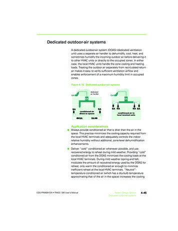
by an electronic map. A map is a spatial object class represented as a relation, where each tuple corresponds to a blockwith the following attributes:Polyline: Each block is a polygonal line segment in 2Drepresenting the shape of the street along this block.L f add: Left side from street numberL t add: Left side to street numberR f add: Right side from street numberR t add: Right side to street numberName: Street nameType: St, Ave, Blvd, or RdZipl: Left side Zip codeZipr: Right side Zip code1600 - 1698 (even) Street41601 - 1699 (odd) Street4B1B31200 - 1248 (even) Street1Parking lot1201 - 1249 (odd) Street11201 - 1249 (odd) Street31200 - 1248 (even) Street3B21600 - 1698 (even) Street21601 - 1699 (odd) Street2Figure 1. Map, trajectory, and stayThus, each street address is on the polyline corresponding to the street block in a map. For example, Figure 1 illustrates four blocks, Street1, Street2, Street3 and Street4 (thefour dash lines are the polylines to represent these streets ina map), and a trajectory (in solid black dots) of a user whofirst driving along street Street1 then parking his car in theparking lot and finally walking into a building B1. Eachstreet has two sides. Each side has either odd or even streetnumbers, e.g., 1200-1248(even)Street3.Often, the user may spend some time in an area, which iscalled a stay [9]. For example, shopping in a supermarketis a stay. As shown in Figure 1, after the user enters thebuilding, he stays there for a while. If the physical locationsare sampled at a fixed rate, then they are dense in a timeinterval. However, driving makes them sparse in the sametime interval.A semantic location about (physical location, time)has three attributes, loc name, semantic category, andstreet address. loc name is the identification of the physicallocation, for example ”BestBuy0312”. semantic categoryrepresents the semantic category about the physical location, for example ”electronic store”. street address is theaddress of the location, for example ”1233 S. Halsted St”.The context represents the environment in which a useroperates. There are two classes of contexts, dynamic contexts and static contexts (also called profile). The dynamiccontext includes information pertaining to a transient statein which the user operates. It contains four attributes:date, begin time, end time, and semantic location. semantic location is the semantic location of a stay S. date is thedate in the format of (month/day/year) when S happens. begin time and end time are the time when S starts and endsin that date. A sequence of user’s dynamic contexts createsa semantic log file (or a log file for short) of the user. Thislog file indicates the semantic location history of the user.The profile includes general information of the user pertaining to many states. Typically, the profile of a user contains the following items:- Calendar, recording events in the form of (event date,semantic location).- Address Book, including the semantic locations andphone numbers related to home, office (if available), school(if available), friends or relatives’ home, etc.- Phone Call List, recording the semantic locations related to the telephone numbers of the user’s outgoing andincoming calls, and the calling dates.- Web Page List, recording the semantic locations aboutlinks that were visited on the Internet, and the visiting dates.- Destination List, recording the semantic locationsabout the destinations whose driving directions are searchedon the Internet, and the searching dates.- User’s Feedback, indicating whether the predicted semantic locations are correct (Confirmed List) or not (DeniedList).Usually, Calendar and Address Book are input by users.They are available on most cell phones, PDAs and PersonalComputers. The telephone numbers and date of calls can beautomatically retrieved from a cell phone. With a phonenumber, we search both on the Internet and the AddressBook. The semantic location related to a business (if available), with that number, can be retrieved from yellow pages,e.g. switchboard1 . The semantic location, whose phonenumber matches the calling number in the Address Book,is also extracted. Thus, the Phone Call List can be builtautomatically. Similarly the Destination List and Web PageList are built. First, from the web page history in user’s webbrowsers, we get the street address of a business related tothe visited web pages, and the street address of the destination. Next, the semantic locations related to the street address can be extracted from yellow pages and the AddressBook. For a web page of a business, it is easy to get the contact confirmation: phone number, street address, etc. Withthese information, Web Page List is built. Phone Call List,Web Page List and Destination List are updated every daywhen the system is idle, i.e. the user doesn’t use the system.User’s Feedback is always input by the user. Confirmed Listand Denied List help in the future prediction.1 www.switchboard.comProceedings of the 7th International Conference on Mobile Data Management (MDM'06)0-7695-2526-1/06 20.00 2006IEEEAuthorized licensed use limited to: University of Illinois. Downloaded on February 18,2010 at 10:27:01 EST from IEEE Xplore. Restrictions apply.
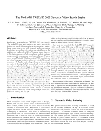
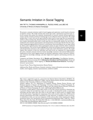
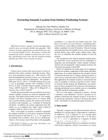
3. Determination of semantic locationTo determine the semantic locations of a user givenhis/her trajectory, our method works as follows (as shown inFigure 2). First, we scan the (physical location, time) in theuser’s trajectory one by one, and extract stays with the physical locations (step 1). Then, in step 2, for each extractedstay S, we get all street addresses that are near the physicalposition of S in a map, using a reverse geocoding method.Thus, for each obtained street address, we search in user’sprofile and yellow pages on the Internet (e.g. switchboard),and get all the semantic locations returned by the search ascandidates (step 3). Thus, an important problem is to chooseone of them as the semantic location of S. We use the following method to make the decision. For each semanticlocation candidate SL of S, we consider the semantic category of SL, the street address of SL and user’s profile asthree different information sources. Then, we compute theutility of each source for determining SL, i.e. the similaritybetween the actual semantic location and SL (step 4.1, 4.2and 4.3). Next, for SL, we compute the weighted sum ofthese three utilities, and choose the one with the maximumsum value as the semantic location of S. Finally, the logfile is updated by adding a new record about this semanticlocation (step 5).Figure 2. ArchitectureOur method requires the participation of users. Withuser’s confirmation, our system will accordingly update thelog file and the feedback in the profile, which in turn is usedfor determining the semantic location in the future.3.1. Extract stays of a trajectory (step1)In order to extract the stays from a given trajectory foroffline applications, we use the similar method introducedin [9, 2]. A stay is that a user spends at least min time inan area where the longest distance between any points inthe area is no more than d. For n continuous physical locations (Pi (xi , yi , ti ), . . . , Pi n 1 (xi n 1 , yi n 1 , ti n 1 ),ti . . . ti n 1 , and ti n 1 ti min time), a newstay S is generated if in the last min time, the maximumdistance of any two physical locations is within d. The center2 of (Pi , . . . , Pi n 1 ) is called the physical location of S,denoted as stay position. For a GPS device, it may be thelast GPS location that appeared. Because no GPS signal isreceived in last min time if the user is in the buildings. Fora physical location following S, there are two situations. Ifit is within the distance of d/2 miles from stay position ofS, it belongs to S, otherwise S ends. A stay has four attributes, stay position, date, stay start and stay end, wherethe last three attributes indicate the date S happens, and thetime when S begins and ends respectively.Figure 3. An example for extracting a stayFigure 3 illustrates an example of the stay generation. Inthis example we suppose that the positioning system generates a physical location every minute. P1 to P10 representsthe 10 physical locations sampled in 10 continuous minutes.Supposing that min time is set as 5 minutes and d is shownin the figure, the stay is generated as follows. In the first4 points, no stay is generated, since 4 minutes is less thanthe min time. Then, we check the first 5 physical locations,P1 , P2 , . . . , and P5 . As the the maximum distance of any 2points in these 5 points is larger than d, no stay is generatedat this time. Similarly for P2 , P3 , . . . , P6 . While for P3 , P4 ,. . . , P7 , a stay is generated, because the maximum distancefor these 5 points is from P3 to P7 , which is less than d.The stay position is P4 , while the stay start 3. After that,P8 is checked. As the distance from P8 to the stay positionP4 of current stay is less than d/2, P8 belongs to currentstay. When P9 is checked, the stay ends, because the distance between P4 and P9 is larger than d/2. So, stay end 8.Such stay generation process is repeated till reaching thelast point of the trajectory.A similar method is used to extract stays for online applications. But it takes min time to get a stay after the userstops somewhere.3.2. Get a set of street address candidates(step2)The traditional reverse geocoding method, returning theclosest street address as the actual street address of a 2D2 The center of n points (P , . . . , Pii n 1 ) is Pk (i k i n 1) such thatd(Pk , Pj ) is minimum, where d(Pk , Pj )j k,i j i n 1is the Euclidean distance between two points Pk and Pj .Proceedings of the 7th International Conference on Mobile Data Management (MDM'06)0-7695-2526-1/06 20.00 2006IEEEAuthorized licensed use limited to: University of Illinois. Downloaded on February 18,2010 at 10:27:01 EST from IEEE Xplore. Restrictions apply.
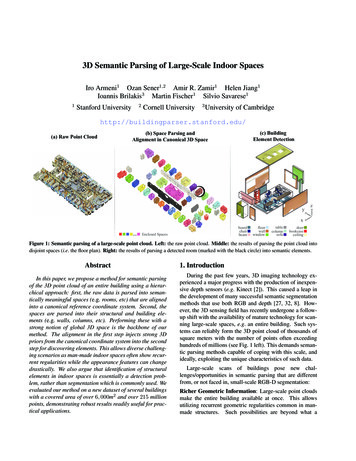
position, usually generates incorrect results. For example,Figure 4 illustrates a street block in a map, two buildings(B1 and B2 ) and their entrances (E1 and E2 ). The traditional reverse geocoding algorithm returns ” 722 W. TaylorSt” as the street address of E2 because E2 is closest to W.Taylor street. However, actually, the address of Building B2is ”850 S. Halsted St”. In addition, the traditional reversegeocoding often generates an incorrect street address evenwhen the entrance is close to the correct street street enough.For example, building B1 ’s address is ”851 S. Morgan St”,whereas, the closest street address is ”823 S. Morgan St”.Figure 4. An example for reverse geocodingTo avoid losing the correct addresses, for a given stay Swith the stay position (x, y) in a map M p, we return a setof street addresses as candidates. The Euclidean distancefrom (x, y) to the physical location of each street address inthis set is less than k. k is a parameter of the system, and iscalled the tolerance threshold.3.3.Get semantic(step3)locationcandidatesWe get the set of semantic location candidates SLC fromthe set of street address candidates SAC obtained in step 2,by searching yellow pages on the Internet and the profile ofthe user. With a street address, yellow pages usually providethe correspondent business name(s), business type(s) (socalled semantic category). Thus for a street address, we getthe semantic location triple (loc name, semantic category,street address).In addition, we extract the semantic locations from theprofile, and add them to SLC as candidates. Specifically,given a stay S and one street address candidate SA of SAC,each item in the profile is examined as follows,- Calendar: for each event e, if S.date is e.date and SAis e.semantic location.street address, e.semantic locationis returned as one semantic location candidate.- Address Book: a semantic location in the AddressBook is returned as one semantic location candidate, if itsstreet address matches SA.- Phone Call List: a semantic location in the Phone CallList is returned as one semantic location candidate, if itsstreet address matches SA.- Web Page List: a semantic location in the Web PageList is returned as one semantic location candidate, if itsstreet address matches SA.- Destination List: a semantic location in the DestinationList is returned as one semantic location candidate, if itsstreet address matches SA.- User’s Feedback: if SA is the street address of oneconfirmed semantic location SLconf irm , SLconf irm is returned as one semantic location candidate.3.4. Calculate three utilities (step4)After step 3, we have a set of semantic location candidates for each stay. Thus we need to determine which oneis the true semantic location of a stay S. For each semanticlocation candidate SL, we consider the semantic categoryof SL, the street address of SL and user’s profile as threedifferent information sources. Then, for determining thelikelihood of SL as the true semantic location, we computethe utility of each source in the same scale range [0,100] insteps 4.1, 4.2 and 4.3 respectively.3.4.1 Semantic category utility (step4.1)Basically, people visit businesses of different semantic categories according to some rules, e.g. a person shops ingrocery stores every Saturday afternoon; one often spendsabout 40 minutes in a grocery store and two hours in a cinema. For such semantic categories related information isimplied in the log file. They can help us to predict the semantic location.We build the semantic category history (or SC history for short) as follows.For each record inthe log file, we extract the start time of the stay,workday or weekend, the time interval spent there3 ,and semantic category as a new record in SC history.Based on the SC history, we give each semantic locationin SLC a semantic category utility (or SC utility for short).A semantic location with a larger SC utility value is morelikely to be the true semantic location of the current staythan the one with a smaller value.We also collect the time information of a stay S, suchas the start time stay start of S, whether S happens in aworkday or weekend, and the time interval spent at the 2Dposition stay position of S.Then, we calculate a SC utility as follows. We use theNaive Bayesian model to calculate the probability that thestay belongs to a semantic category Ci appearing in any SLin SLC as:3 P (Ci T1 , T2 , T3 ) Z P (Ci ){P (Tj Ci )} (1)j 13 Thisinformation is obtained by stay end stay start. It is notavailable for online applications, so ignore it for online cases.Proceedings of the 7th International Conference on Mobile Data Management (MDM'06)0-7695-2526-1/06 20.00 2006IEEEAuthorized licensed use limited to: University of Illinois. Downloaded on February 18,2010 at 10:27:01 EST from IEEE Xplore. Restrictions apply.
Now we present the method to compute the street addressutility (or called SA utility for short). The semantic location candidates with different street addresses in SLC havedifferent probabilities to be the correct semantic location ofthe stay. We set a street address utility for each semantic location candidate SL, based on the street address of SL andthe following the observation: For the stay position (x, y) of a stay, the street addressof the projection point p on each street has the highestprobability thus (i.e. SA utility), to be the street address of (x, y). In addition, the street addresses near phave larger probabilities than the ones far from it.Thus, if the street address of SL is the street address ofthe projection point on the same street, then the SA utilityof SL is assigned the largest value of the scale, e.g., 100for the scale of the range [0,100]. Otherwise, the SA utility of SL is inversely proportional to the distance betweenthe correspondent projection point on the same street andthe stay position (x, y). Figure 5 illustrates an example. Adenotes the stay position of a stay S. A1, A2, A3 and A4are the projection points of A on streets Street1, Street2,Street3 and Street4 respectively. The street addresses ofA1, A2, A3 and A4 have the highest SA utility values, whilethe street address A1 has a smaller SA utility value.3.4.3Profile utility (step4.3)The profile utility UP is calculated from the profile of theuser. For each semantic location candidate SL of a stay S,initially, the profile utility UP of SL has 20 credits. Thecredits value of UP of SL increases, if SL matches (or issimilar to) the following items of the profile:- Calendar: SL matches an event e in the Calendar ifS.date e.date and SL e.semantic location. One matchhas 80 credits. Not matching has 0 credit.4 http://www.cs.waikato.ac.nz/ml/weka/Parking lotA1'B1AB3A21201 - 1249 Street1Street address utility (step4.2)A3B21200 - 1248 Street13.4.21600 - 1698 Street41601 - 1699 Street4A41201 - 1249 Street31200 - 1248 Street3where T1 , T2 , T3 are the time-related attributesof the stay:start time, workday or weekend,respectively.andthe time interval spent thereP (Ci T1 , T2 , T3 ) is the probability that a stay, withthe correspondent values of T1 , T2 , T3 , belongs to Ci .P (Ci ) is the unconditional probability of a stay belongingto Ci . P (Tj Ci ) is the probability of a record, whoseTj is the correspondent value, in Ci . Z is the value fornormalization so that the sum of the all probabilities is 1.We use the weka software 4 to compute the probability.In order to keep the SC utility in the same scale of the range[0,100] with other two utilities, the value of each SC utilityis multiplied by 100.A11600 -1698 Street21601 -1699 Street2Figure 5. An example for calculating SA utility- Address Book: If SL matches a semantic location inthe Address Book, credit is 70. Not matching has 0 credit.- Phone Call List: if SL is in the Phone Call List, thecloser the call to S.date, the higher the credit is; otherwise,the credit is 0. That is, if SL is the semantic location ofone call, the credits of the match is (80 minus the numberof days between S.date and the date of the call).- Web Page List: if SL is in the Web Page List, the closerthe date when the web page is visited to S.date, the higherthe credit is; otherwise, the credit is 0. That is, the creditsof the match between SL and a web page is (80 minus thenumber of days between S.date and the date when the webpage is visited).- Destination List: if SL is in the Destination List, thecloser the date when the destination is searched on the Internet to S.date, the higher the credit is; otherwise, thecredit is 0. That is, the credits of the match between SLand a searched destination is (80 minus the number ofdays between S.date and the date when the destination issearched).- Confirmed List: SL matches a record in the ConfirmedList if SL is found in the list. One match has 70 credits.Not matching has 0 credit.For each item above, we calculate the matching credits of them5 . Then we select the maximum value of thesematching credits as the increment value of UP . In addition, if there is a match between SL and one item inthe Denied List, the value of UP decreases by 20 credits.The total decrement is called debt. In summary, UP 20 max(matching credits) debt.3.5. Decide the semantic location (step5)Now, for a stay S, we have many semantic location candidates, each of which has the three utilities. By assigninga weight to each utility, we compute the weighted sum for5 Thecredit can not be negative. Set it as 0 if it is negativeProceedings of the 7th International Conference on Mobile Data Management (MDM'06)0-7695-2526-1/06 20.00 2006IEEEAuthorized licensed use limited to: University of Illinois. Downloaded on February 18,2010 at 10:27:01 EST from IEEE Xplore. Restrictions apply.
each semantic location candidate SL, as:Sum wSA USA wSC USC wP UP(2)where USA , USC and UP are utility values for the SA utility, the SC utility and the profile utility respectively; andwSA , wSC and wP are the weights for each of them. Thesemantic location candidate with the maximum sum is selected as the semantic location of S.So the problem is how to set the weight of each utility.Remember that the values of the three utilities are in thesame scale. For this situation, in the area of multi-attributesevaluation [4], there are three popular ways to set the weightfor each attribute/utility: Equal or unit weighting: Set all attributes to haveequal weights. This method is used when it is hardto give weights to attributes. Or people give widelydifferent weights and it is hard to resolve the conflict. Rank weighting: Assign the largest rank number tothe most important attribute, the next highest numberto the second most important attribute, and so on untilthe least important attribute receives the rank 1. Usethe rank as the weight. This method is used when theexact weight is not clear, but people do know the importance sequence of the attributes. Ratio weighting: Set the ratio for the weights basedon experience and/or knowledge. This method is usedwhen people know the importance of attributes verywell.Since we don’t exactly know the importance ratio of thethree utilities, the third method is not evaluated in this paper.In the next section, we compare the first two methods. Forthe second method, fortunately, we have only three utilities.Therefore, all the possible ranks can be evaluated, which is6 in total.3.6. InitializationInitially, the log file is empty. And user’s feedback isnot available. In this case, it is hard to decide the semanticlocations for user’s stays, since the SC utility is not available and the profile utility does not work well without user’sfeedback. To build the log file and user’s feedback, weneed a stage of initialization. To reduce the disturbance tothe user, the initialization process works as follows. Theuser carries a positioning system (e.g. a GPS receiver) anywhere he/she goes for collecting the trajectories. After twoor three weeks, he/she checks his/her credit card statement,copies and pastes the statement to our system. Basically,the credit card statement shows the information of eachpurchase: date, business name, standard purchase/Internetpurchase, amount, etc. For each date, from the trajectory,we extract several stays and then the set of semantic location candidates SLC by the method described in Section3.1 to Section 3.3. Thus we have two kinds of informationcoming from independent sources: business names (withdate) the user visits from credit card statement, and SLCand time information (date, arrival time, etc.) by our methods. To determine the semantic location for each stay, wejust need to match the several businesses in the credit cardstatement with the SLC by a business name, for every dayin the initialization stage. Furthermore, some information inthe profile can help to decide the semantic locations. Thenthe user’s confirmation/correction is needed to build the logfile and user’s feedback in the profile.The user is required to confirm and correct the semanticlocations in the initialization stage. After that, only confirmation is required.4. ExperimentIn this section, we first describe our experiment data andsettings in subsection 4.1, then present the experimental results in terms of the accuracy of the generated semantic locations in subsection 4.2.4.1. Experiment data and settingWe have collected the trajectories of a student’s trip bya GPS receiver on a PDA for 4 months. The GPS locationis sampled every second. The correct semantic location ofeach stay is recorded manually by the student. So we cancompare our predicted semantic location with the correctone. In the 4 months, the student had 224 stays, which belongs to 17 different semantic locations. We transfer theGPS data from the PDA to a PC and do the experiment onthis PC.GPS receivers usually give inaccurate physical locations,especially in the area with trees and buildings nearby. Toavoid the noise of the GPS data, we use the average positionof N seconds6 to represent the physical position for that timeinterval. N is a parameter of the system. Our experienceshows that 15 seconds is a good value for N. In addition,tolerance threshold k (see Section 3.2) is 0.15 mile.The profile of this student is built as described in Section 3. There is only one semantic location visit (a hospitalvisit) recorded in Calendar. There is only one link with itssemantic location (a government office) is in Web Page Listand Destination List. We do not have any semantic locations in Phone Call List. We assume that the user checksthe log file and gives feedback every week.6 The average position of N seconds is a position with 2D coordinatesmm, y y1 y2 . y, t1 t 2 (x, y) such that x x1 x2 . xmm. . . tm , and tm t1 N seconds.Proceedings of the 7th International Conference on Mobile Data Management (MDM'06)0-7695-2526-1/06 20.00 2006IEEEAuthorized licensed use limited to: University of Illinois. Downloaded on February 18,2010 at 10:27:01 EST from IEEE Xplore. Restrictions apply.
We use the map from Geographic Data Technology7 , andonline yellow page switchboard in the experiment.In Section 3.5, we discussed the two methods, equalweighting and rank weighting, for setting the weights of thethree utilities. In our experiment, for the equal weightingmethod, wSA wSC wP 1. For the rank weightingmethod, we evaluate every possible rank combination for(wSA ,wSC ,wP ): (1, 2, 3), (1, 3, 2), (2, 1, 3), (2, 3, 1), (3,2, 1), (3, 1, 2). We randomly select the data of 2 weeks, 3weeks and 4 weeks as the input of initialization (see Section3.6). The data for the rest of time is used as the evaluationdata. For each setting,
between the actual semantic location and SL(step 4.1, 4.2 and 4.3). Next, for SL, we compute the weighted sum of these three utilities, and choose the one with the maximum sum value as the semantic location of S. Finally, the log file is updated by adding a new record about this semantic location (step 5). Figure 2. Architecture