Transcription
TCEQ REGULATORY GUIDANCERemediation DivisionRG-366/TRRP-12 Revised May 2010Affected Property AssessmentRequirements under TRRPObjectives:This document outlines the requirements for defining the three-dimensional extent of theaffected property and protective concentration level exceedance zone pursuant to the TexasRisk Reduction Program (TRRP).Audience:Regulated Community and Environmental ProfessionalsReferences:The Texas Risk Reduction Program (TRRP) rule, together with conforming changes torelated rules, is contained in 30 Texas Administrative Code Chapter 350. The TRRP rulewas initially published in the September 17, 1999 Texas Register (24 TexReg 7413-7944).The rule was amended in 2007 (effective March 19, 2007; 32 TexReg 1526-1579) and 2009(effective March 19, 2009; 34 TexReg 1861-1872).Find links for the TRRP rule and preamble, Tier 1 PCL tables, and other TRRP informationat: www.tceq.state.tx.us/remediation/trrp/.TRRP guidance documents undergo periodic revision and are subject to change.Referenced TRRP guidance documents may be in development. Links to current versionsare at: tact:Remediation Division Technical Support Section - 512-239-2200, ortechsup@tceq.state.tx.us.For mailing addresses, refer to: hen addressing an unauthorized release of a chemical of concern (COC)under TRRP, the person is required to conduct an affected propertyassessment in accordance with §350.51. The affected propertyassessment has many goals and purposes such as: identifying source areas and types of COCs, characterizing the geologic and hydrogeologic properties of the areathat influence COC fate and transport, determining COC migration pathways, and evaluating exposure pathways.This information is then used to determine the nature and extent of COCs.To that end, this document provides guidance to aid in establishingassessment levels, explains how to define the affected property andTEXAS COMMISSION ON ENVIRONMENTAL QUALITY PO BOX 13087 AUSTIN, TX 78711-3087T he T CEQ i s an equal opport unit y em pl oyer. T he agency does not al l ow di scrimi nat i on on t he basi s of race, col or, reli gi on, nati onal ori gi n, sex,di sabilit y, age, sex ual ori ent ati on, or v eteran st at us. I n compli ance wi t h t he Am ericans wi t h Di sabiliti es Act, t hi s docum ent m ay be request ed i nal t ernat e f ormat s by cont act i ng t he T CEQ at 512- 239- 0028, f ax 512-239- 4488, or 1-800- RELAY-T X (T DD), or by writi ng PO Box 13087, Austi n T X78711- 3087. W e aut hori ze you t o use or reproduce any ori gi nal mat eri al cont ai ned i n t hi s publi cati on — t hat i s, any m at eri al we di d not obt ai n f romot her sources. Pl ease acknowl edge t he TCEQ as your source. Pri nt ed on recycl ed paper.
Affected Property Assessment Requirements under TRRPTCEQ publication RG-366/TRRP-12protective concentration level exceedance (PCLE) zones, and discussessome issues that may be encountered that warrant specific consideration.Determining the Assessment LevelThe term “assessment level” is used in TRRP to denote the concentrationto which the three-dimensional extent of a COC in the environment mustbe assessed. The assessment level always includes human healthexposure pathway considerations, and when appropriate, ecologicalexposure pathways considerations. An assessment level is typically acalculated risk-based value that factors in different exposureconsiderations for different environmental media (e.g., surface soil,subsurface soil, groundwater) as well as COC-specific physical andchemical properties, and toxicity factors. Human health considerationsare based on residential exposure.Table 1 identifies some site-specific inputs that are necessary to determinethe assessment level. With the exception of source area sizeconsiderations and standard exposure pathways, the different topics areaddressed in other guidance documents. See the documents referenced inTable 1 for details on those subjects. With regard to more explanation oftheir bearing on setting assessment levels, see TCEQ guidance documentAffected Property Assessment Planning (RG-366/TRRP-6).Table 1. Important Information for Establishing Assessment Levels.TopicImpactGuidance DocumentTarget COCsThe assessment must consider the appropriate COCs sinceassessment levels are COC-specific values that reflect the toxicity TRRP-10and chemical/physical properties of the COC.Groundwater1ClassificationGroundwater classification establishes relevant exposurepathways.TRRP-8Applicability of2Ecological RisksAn assessment level includes ecological screening benchmarksand PCLs when there are ecological exposure concerns.Ecological levels can be lower than the human health-basedassessment levels.RG-263 (revised)Method Quantitation3Limits/BackgroundThe MQL or background concentration may substitute for theassessment level when it is a higher value.Source Area SizeAssessment levels for certain exposure pathways are dependenton the source area size of the COC.TRRP-13 (MQL)TRRP-15 (Background)This document1.If unknown, assume Class 1 groundwater.2.Can set assessment levels initially on human health and later define ecological PCLs, but at risk of mobilizing foradditional assessment.3.Establishing a background concentration is optional, but it may prevent setting assessment levels inappropriatelylow for a COC, such as an inorganic COC that is naturally occurring in the environment.2Revised May 2010
TCEQ publication RG-366/TRRP-12Affected Property Assessment Requirements under TRRPThere are some practical limits for assessment levels. When thecalculated assessment level is within the background concentration rangefor the COC or is less than the method quantitation limit (MQL) for themost sensitive standard available method for that COC, then thebackground concentration range or the MQL is the assessment level.Also, if the person satisfactorily demonstrates that all reasonably availableanalytical technology has been used to show that the COC concentrationcannot be measured to the MQL due to sample-specific interferences, thenthe sample detection limit (SDL) can be used as the assessment level.More thorough discussions of background concentrations, includinganthropogenic background concentrations and acceptable practices forestablishing background concentrations, and MQLs are presented inTCEQ guidance documents Representative Concentrations (RG-366/TRRP15) and Review and Reporting of COC Concentration Data (RG-366/TRRP13), respectively.This section explains the basis of an assessment level, identifies necessaryinformation and considerations for setting an assessment level, and detailshow the assessment level for each environmental medium is determined.Assessment Level BasisBoth human health and ecological exposure pathways are considered insetting applicable assessment levels. For human health exposurepathways, assessment levels are based primarily on residential Tier 1protective concentration levels (PCLs). However, for the soil-togroundwater (GWSoil) exposure pathways, the assessment level can bebased on a Tier 1, 2 or 3 PCL. See Tiered Development of Human HealthPCLs (RG-366/TRRP-22) for further information on the tiered process.Tier 1 PCL tables are available for download tml. Refer to the TCEQguidance document Tier 1 PCL Tables (RG-366/TRRP-23) for additionalguidance on choosing the appropriate Tier 1 PCL.Prior to setting assessment levels for ecological concerns, complete a Tier1 Exclusion Criteria Checklist to determine the existence of complete andpotentially significant ecological exposure pathways at the affectedproperty. If the property does not meet the exclusion criteria, the personmay either submit a reasoned justification or conduct an expedited streamevaluation, either of which may be used to conclude the ecological riskassessment process. See Section 2.0 of Guidance for ConductingEcological Risk Assessments at Remediation Sites in Texas (RG-263(revised)) for further information on the reasoned justification orexpedited stream evaluation. If it is determined that further ecologicalevaluation is needed, proceed into Tiers 2 or 3 of the ecological riskassessment process to set the applicable ecological assessment levels (seeSection 1.5 of RG-263 (revised)). See the Human Health and EcologicalRevised May 20103
Affected Property Assessment Requirements under TRRPTCEQ publication RG-366/TRRP-12Assessments section of this document for further ecological assessmentdiscussion.Setting the Assessment Levels for Each Environmental MediaThis section works through the process ofAssessment Level Notessetting the assessment levels. AssessmentThe term assessment levelincludes, as appropriate forlevels are determined for each COC in eachthe affected property, theaffected environmental medium for theevaluation of human healthapplicable residential human health orexposure pathways,ecological exposure pathways. Table 2 lists theecological exposurepathways, the MQL, andminimum applicable exposure pathways foreach environmental medium and lists the TRRP background concentrations.nomenclature for the exposure pathways. Thenomenclature is also used to refer to the PCL for an exposure pathway.There may be other pathways specific to the affected property (Table 2)that must be taken into account when determining assessment levels. Anexample of a fairly common exposure pathway not specified in rule is soilerosion due to surface runoff and deposition in surface water andsediment. TCEQ guidance document Determining PCLs for Surface Waterand Sediment (RG-366/TRRP-24) discusses exposure pathways to considerwhen surface water and sediment are affected or threatened.Table 2. Assessment Levels for Human Health Exposure Pathways.Exposure PathwayExposure PathwayNomenclatureCombined ingestion, dermal contact, inhalation of volatileand particulate emissions, and ingestion of aboveground andbelow-ground vegetables with COCs in soil.Environmental MediumTotSoil CombSurface soilInhalation of volatile COC emissions from soil.AirSoil Inh-VSubsurface soilProtection of groundwater from soil leachate.GWSoil*Surface and subsurface soilIngestion of COCs in groundwater.GWGW IngClass 1 and 2 groundwaterManagement of COCs in Class 3 groundwater.GWGW Class3Class 3 groundwaterInhalation of volatile COC emissions from groundwater.AirOther completed or reasonably anticipated to be completedexposure pathways such as groundwater COC discharging tothe surface water or sediment.GW*4Soil includes:GWSoil Ing ,GWSoil Class3 ,AirGW-Soil Inh-V , andUpper-most Class 1, 2 or 3groundwaterGW Inh-VGWSWGW,SedGWAll environmental mediaSoil for secondary MCLs, as applicable.Revised May 2010
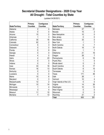
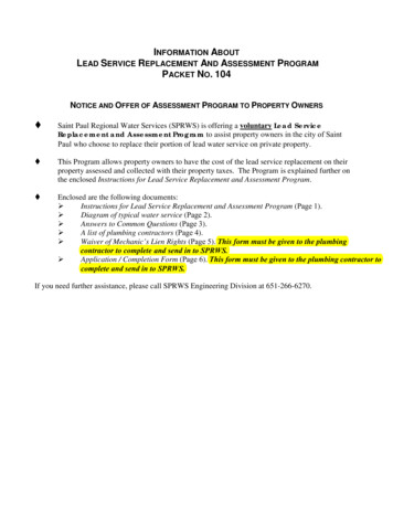
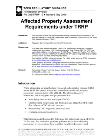
TCEQ publication RG-366/TRRP-12Affected Property Assessment Requirements under TRRPConsideration of Source Area Size for Cross-Media ExposurePathwaysTier 1 PCLs for cross-media exposure pathways are calculated for 0.5-acreand 30-acre source area sizes. A cross-media exposure pathway is anexposure pathway where there is COC transport from the source area inone environmental medium (e.g., soil) to the point of exposure in anotherenvironmental medium (e.g., air). Cross-media exposure pathwaysinclude GWSoil, AirSoil Inh-V and AirGW Inh-V . The size of the source area isimportant because if other factors are held constant, the larger the sourcearea, the higher the COC concentration that is delivered to the exposurepoint. Therefore, as source area size increases, the PCL decreases. Sourcearea size is not relevant for exposure pathways that do not include a COCtransport component (e.g., GWGW Ing ).The source area is the portion of an environmental medium with COCconcentrations that are leaching, dissolving or emitting an unprotectiveCOC concentration to a point of exposure. The source area is not theprimary release source such as a tank or a pipe. However, the source areais generally at or below the primary release source, such as a tank, drum,or landfill. Unfortunately, when multiple sources or diffuse sources arepresent, identifying the source area may be difficult.The determination of source area size can beAssessment Level Notessomewhat subjective. Therefore, the ruleBecause the 30-acre assessmentstandardized the source area sizelevel is a lower value than the 0.5acre assessment level, consider usingdetermination to expedite establishing thea 30-acre source area as theappropriate assessment level [§350.75(b)(2)].delineation criteria from the start toBegin with a 0.5 acre-based assessment level.reduce mobilizations for additionalMap the lateral extent of COC concentrationsassessment.in the environmental medium that exceedsthe assessment level (affected) and determine if the surface area of theportion of the environmental medium that is affected (affected surfacearea) for that COC is less than or greater than 0.5 acres (Table 3). If theaffected surface area is less than or equal to 0.5 acres, then use the 0.5acre-based assessment level. As an example in Figure 1, the assessmentlevel in surface soil for COC X is based on the 0.5-acre GWSoil Ing PCL.Using the 0.5-acre assessment level, the affected surface area of COC X insurface soil is less than 0.5 acres. Therefore, the 0.5 acre-basedassessment level is the proper value to use.Revised May 20105
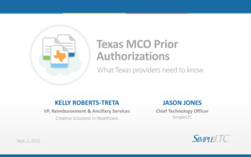
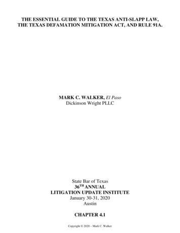
Affected Property Assessment Requirements under TRRPTCEQ publication RG-366/TRRP-12Table 3. Definition of Source Area SizeIf the affected surface area is 0.5 acres, use the 0.5-acre assessment levelIf the affected surface area is 0.5 – 30 acres, use the 30-acre assessment levelTier 1Tier 2 or 3If the affected surface area is 30 acres based on §350.75(b)(2) methodology, use anassessment level established under Tier 2 or 3 methodologies for site-specific source areasize.The volume of COCs in an environmental medium that is leaching, dissolving, or emittingunprotective COC concentrations to the point of exposure.In situations wherethe affected surfacearea using a 0.5 acrebased assessmentlevel is greater than0.5 acres, but lessthan or equal to 30acres, then use a 30acre-based assessmentlevel (Table 3). Ascan be seen in Figure1, the surface area ofbenzeneconcentrationsFigure 1. Source area size using Tier 1 PCLs.exceeding the 0.5-acreassessment level is 4 acres. Since 4 acres is greater than 0.5 acres, but lessthan 30 acres, the 30-acre assessment level must be used. If the extent ofCOC concentrations is not already defined to the 30 acre-basedassessment level, then further assessment is required to achieve that end.The rule does not address the situation where the affected surface area isgreater than 30 acres as with benzene in groundwater in Figure 2. In sucha situation, it isrecommended that theperson define thesource area sitespecifically, andestablish anassessment levelaccordingly using Tier2 or 3 methodologies(Table 3). The sourcearea will typically bethe area containingnon-aqueous phaseliquid (NAPL) and thehighest COCFigure 2. Source area size using Tier 2 PCLs.concentrations. In6Revised May 2010
TCEQ publication RG-366/TRRP-12Affected Property Assessment Requirements under TRRPthe example in Figure 2, it was determined that the groundwater sourcearea is the NAPL in contact with the groundwater-bearing unit. This alsoemphasizes the point that while delineation of the boundary of theaffected property is necessary, it is just as important to adequately definethe areas of highest COC concentrations. This information is useful fornot only determining the source area size, but will be needed later in theresponse action process when evaluating effective remedies.Keep in mind that the source area size is defined in terms of the affectedsurface area size for each COC in each environmental medium.Therefore, the source area for one COC may be less than 0.5 acres whilethe source area for another COC in the same environmental medium maybe larger than 0.5 acres.There is another factor to keep in mind. Because the GWSoil exposurepathway is applicable to both surface and subsurface soil, the same sourcearea size (the largest of the source area size in surface or subsurface soil)should be assumed for surface and subsurface soil for a given COC.A Note About Assessment LevelsFor site-specific reasons, assessments may bedirected to proceed to concentrations lowerthan assessment levels defined according tothe procedures described in this section.Typically, this would occur due to concern overother reasonably anticipated to be completedexposure pathways. For example, there maybe concern that groundwater COCs aredischarging to surface water. Additionalinvestigation may be required to fullyinvestigate the possibility.Groundwater Assessment LevelTable 4 lists the exposure pathways usedto determine the groundwaterassessment level. The assessment levelis the lowest value for the applicablehuman health and ecological exposurepathways. Use residential exposurefactors for both residential andcommercial/industrial property alike. Ifthe classification of the groundwater isunknown, assume it is Class 1 (see TCEQ guidance documentGroundwater Classification (RG-366/TRRP-8) for further information).Table 4. Groundwater Assessment Levels.11Class 1 or 2 GroundwaterClass 3 GroundwaterLowest of:Lowest of:Tier 1GWGW Ing (residential)Tier 1GWTier 1AirGW Inh-V (residential)Tier 1Air2GW Class3 (residential)GW Inh-V (residential)2Tier 2 or 3 Ecological PCLTier 2 or 3 Ecological PCL3Other exposure pathway anticipated to be complete1.All delineation requirements also include the higher of background concentrations or the MQL/SDL ifgreater than the others.2.Typically not applicable to groundwater.3.For example, groundwater discharge to surface water (SWGW) or sediment (SedGW).Revised May 20103Other exposure pathway anticipated to be complete7
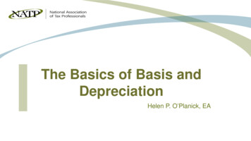
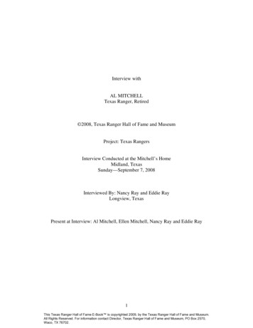
Affected Property Assessment Requirements under TRRPTCEQ publication RG-366/TRRP-12Soil Assessment LevelFigure 3 identifies the key decision points and suggested sequence forestablishing soil assessment levels.The assessment level can be different in surface soil than in subsurfacesoil. Refer to Table 5 for the criteria used to determine soil assessmentlevels. The assessment level in surface soil is the lowest of the values forthe Tier 1 TotSoil Comb , GWSoil determined under Tier 1, 2, or 3, anyapplicable ecological exposure pathway, and for any other applicableexposure pathways such as soil runoff to surface water or sediment (Table5). The assessment level for subsurface soil is lowest of the values for theTier 1 AirSoil Inh-V , GWSoil determined under Tier 1, 2, or 3, and any otherapplicable exposure pathway. All human health assessment levels aredetermined using residential exposure factors. However, as discussedlater in the Focused On-Site Soil Assessment section of this document,there is the ability to focus the assessment on defining the PCLE zonewhich may be either residential or commercial/industrial based.Concentrate the assessment on the 0.5-acre assessment level. If themapped affected source area is greater than 0.5 acres, then use the 30acre-based assessment level (Figure 3).For both surface soil and subsurface soil, the background concentrationsor MQL may become the assessment level when the backgroundconcentration exceeds the human health and ecological PCLs, or the MQLusing the most sensitive available analytical method is higher than thePCL and background concentrations. For example, the Tier 1 GWSoil PCLfor lead is 3.0 mg/kg, but since the Texas-specific median backgroundconcentration is 15 mg/kg [§350.51(m)], the background concentration of15 mg/kg (or a higher site-specific background concentration) substitutesfor the assessment level.Ecological Soil Definitions and Assessment LevelsEcological exposure pathways are typically limited to the soil intervalbetween ground surface and a depth of five feet. However, that five-footinterval is subdivided into surface soil (ground surface to a depth of sixinches below grade) and subsurface soil (six inches to five feet belowgrade) (Table 5). The ecological assessment level for these two soilintervals may be different values. Therefore, take particular care toinclude the correct ecological assessment level for the proper soil intervalwhen comparing the ecological and human-health-based assessmentlevels.Vertical Assessment ConsiderationsUnless a groundwater assessment has been completed, define the verticalextent of COC concentrations in soil vertically to the background8Revised May 2010
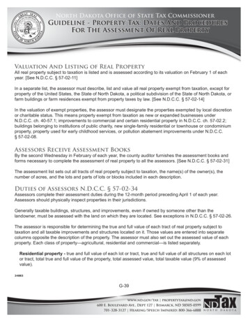
TCEQ publication RG-366/TRRP-12Affected Property Assessment Requirements under TRRPconcentrations or to the MQL for the most sensitive standard availablemethod for the COC; whichever is higher (Table 5, Figure 4). The purposeof this requirement is to determine whether groundwater is affected. Ifthe upper-most groundwater-bearing unit is encountered prior to reachingbackground concentrations or the MQL in soil, then sample groundwaterto determine if it is affected by the COC release. If a groundwaterassessment has been completed, then the vertical assessment mayterminate at the assessment level, regardless of whether the groundwateris affected or not. In this instance, the groundwater assessment mustinvolve direct sampling of groundwater. Other special considerations arediscussed later concerning §350.75(i)(7)(C).If a groundwater assessment documents that the groundwater is affectedby COCs, then the entire soil column bounded horizontally by theassessment level from the ground surface to the top of the lowest affectedgroundwater-bearing unit may be considered a PCLE zone (Figure 4).Declaring the entire soil column a PCLE zone means that no furthervertical soil delineation above the lowest affected groundwater-bearingunit is needed for purposes of defining the affected property. However, asoil response action will be required. This may be a preferred optionwhen the affected soil is overlain by a physical control such as animpervious cover and that cover may suffice as a control remedy. Byassuming the soil beneath an impervious cover is a PCLE zone, the degreeof assessment beneath that cover can be minimized. However, additionalcharacterization of the soil may be needed to design an appropriateresponse action or to ensure the impervious cover is large enough, or willotherwise meet the performance requirements.Revised May 20109
Affected Property Assessment Requirements under TRRPTCEQ publication RG-366/TRRP-12Start for each COCDetermine the Tier 1 residential TotSoilComb PCL for 0.5acre source area in surface soil (§350.75(i)(6))orthe Tier 1 residential AirSoilInh-V PCL for 0.5 acre sourcearea in subsurface soil (§350.75(i)(8)).If the site needs to proceed to aTier 2 or 3 ecological riskassessment, then determine theappropriate ecological screeningbenchmark or PCL.Determine theresidential GWSoilPCL at any tier.1Select the lowest ofthe values.Note 1. Field data is needed tosupport Tier 2 or 3 GWSoilcalculations.Note 2. Use direct comparison.Is the MQL/SDL orbackground higher than thelowest applicable screeningbenchmark (eco) or PCL(human healthor eco)?YesThe higher of MQL/SDL or backgroundbecomes the assessment level. Delineate tothat level. 2NoThe lowest applicable PCLis the assessment level. Delineate to thatlevel. 2Is theaffected surface areagreater than 0.5 acresin size?NoUse the 0.5 acre assessmentlevel to define the affectedproperty.YesConduct assessment todelineate to 30-acreassessment level. 2YesIs theaffected surface areagreater than 30acres in size?Use Tier 2 or 3 methods to determine sitespecific assessment level and delineate theaffected property to that level.NoUse the 30-acre assessment level to definethe affected property.Figure 3. Determining Soil Assessment Levels10Revised May 2010
TCEQ publication RG-366/TRRP-12Affected Property Assessment Requirements under TRRPTable 5. Soil Assessment Levels.1Subsurface Soil1Surface Soil(0-15 ft.)2( 15 ft.)Lowest of: (residential)Tier 1TotTier 1GWLowest of: (residential)Soil CombSoil3or Tier 2GWor Tier 3GW2Tier 1AirTier 1GWSoilSoilSoil Inh-V3Soilor Tier 2GWor Tier 3GWSoilSoilTier 2 or 3 Ecological PCL (0 to 0.5 feet)Other exposure pathway anticipated to be completeTier 2 or 3 Ecological PCL (0.5 to 5 feet)Other exposure pathway anticipated to be completeOther exposure pathway anticipated to be completeOther exposure pathway anticipated to be complete1. All delineation requirements also include the higher of background concentrations or the MQL/SDL ifgreater than the others.2. Or to the depth of bedrock or the upper-most groundwater-bearing unit if within this interval.3.GWSoil includes:GWSoil Ing ,GWSoil Class3 ,AirGW-Soil Inh-V , andGWSoil for secondary MCLs, as applicable.Additional Requirements for Assessment of the Vertical Extent for SoilCOCs If groundwater has not been assessed: higher of MQL/SDL orbackground concentrations. If groundwater has been assessed: standard assessment level, orevidence of groundwater protectiveness (§350.75(i)(7)(C)). If groundwater has been assessed and is impacted, option to declaresoil PCLE zone.Revised May 201011
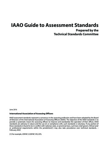
Affected Property Assessment Requirements under TRRPNoDefine vertical limit of COCsin soils to higher of MQL/SDLor background. Samplegroundwater if encountered.Continue vertical definition insoil if COCs are likely to havemigrated deeper than theuppermost groundwaterbearing unit.TCEQ publication RG-366/TRRP-12Has a groundwaterassessment beenconducted?If groundwater isaffected, optionto declare entiresoil column asPCLE zone.YesDefine toSoil set atany tier.GWorProvide evidenceor of groundwaterprotectiveness(§350.75(i)(7)(C)).(See Section onAlternative to GWSoilPCL.)Figure 4. Vertical Soil Delineation.Defining the Affected PropertyThe affected property includes the entire on-site and off-site extent ofenvironmental media (soil, groundwater, air, surface water and sediment)with COC concentrations equal to or greater than the assessment levelapplicable for residential land use and the groundwater classification.The affected property is a three-dimensional determination of affectedenvironmental media.Figure 5 illustrates several key points about an affected property. First,the extent of an affected property is not limited by real estate boundaries.As can be seen in Figure 5, an affected property can extend over differentproperty holdings (i.e., onto on-site property and off-site properties).Assessments will frequently needto progress onto off-site properties.Further examination of Figure 5also reveals that an affectedproperty can be comprised ofdifferent affected environmentalmedia. For example, an affectedproperty can be comprised ofaffected surface soil, affectedsubsurface soil, and/or affectedgroundwater. Affected sedimentand surface water can be part ofan affected property. All of theenvironmental media affected by a12Figure 5. Relationship Between Affected Media, theAffected Property, and Property Boundaries (map view).Revised May 2010
TCEQ publication RG-366/TRRP-12Affected Property Assessment Requirements under TRRPgiven release incident comprise the affected property.Determine the extent of the affected property by a direct comparison of themeasured concentration for each COC at each sampling location in eachenvironmental medium to the applicable assessment level. All thosesampling locations with COC concentrations in excess of the assessmentlevel constitute the affected property. COC concentrations within aspecific medium may be contoured by inference and interpolationbetween data points, or by other means appropriate for evaluation of theaffected property limits. It is not appropriate to use an average of COCconcentrations to identify the affected property. Refer to DeterminingRepresentative Concentrations (RG-366/TRRP-15) for more information onwhen averaging can be used and acceptable statistical methods foraveraging.In some instances, the direct comparison approach to defining theaffected property will result in a “Swiss cheese” effect where the “holes”in the affected property are areas where measured concentration levels areless than the assessment level. In general, the person has the discretion to“lump” the concentration “holes” into the affected property, or to excludethe concentration “holes” from the affected property as is preferable to theperson upon considering such factors as real property line boundaries,notification implications under §350.55, or other factors such as datasufficiency upon which to define the concentration islands. There isfurther discussion of the issue of “holes” in the Defining the PCLE Zonesection of this document.Finally, Figure 5 illustrates that there may be more than one affectedproperty at any given property or facility. If there are release incidentsaffecting different portions of environmental media, then there areaffected properties for each of those release incidents.Conduct the assessment in a manner most likely to detect the presenceand distribution of COCs above the applicable assessment levelconsidering the nature of the release and site conditions. Collectrepresentative samples from all environmental media that are, or couldbe, affected by tailoring the sampling regime to each situation based onthe location and type of release, COC characteristics, and geologic andhydrogeologic considerations. Use rapid assessment techniques (e.g.,push tools, narrow diameter wells, on-site analytical) when appropriate asdiscussed in TCEQ guidance document Affected Property AssessmentPlanning (RG-366/TRRP-6). Anticipate the need for appropriately locatedmonitoring points for long-term monitoring. Ongoing groundwatermonitoring is critical to identify and evaluate the trends in COCconcentrations and distribution, groundwater flow, geochemicalparameters, and groundwater gradient information that are important fordetermining appropriate response actions. The number
the sample detection limit (SDL) can be used as the assessment level. More thorough discussions of background concentrations, including anthropogenic background concentrations and acceptable practices for establishing background concentrations, and MQLs are presented in TCEQ guidance documents .