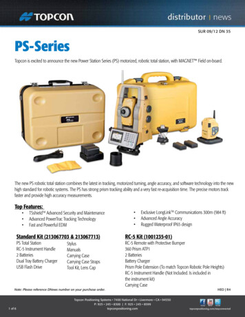
Transcription
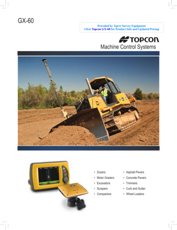
GX-60Provided by Xpert Survey EquipmentClick Topcon GX-60 for Product Info and Updated PricingMachine Control Systems Dozers Asphalt Pavers Motor Graders Concrete Pavers Excavators Trimmers Scrapers Curb and Gutter Compactors Wheel Loaders
3D-MC Machine Control Systems3D-MCINDICATE SYSTEMThe Topcon 3D-MC indicate system is a low cost indicate-only system ideal for bulkearthmoving machines such as dozers. The GX-30 or GX-60 color touch-screen controlbox displays where the machine is on the job site and provides constant cut/fill information.Experience the productivity of GNSS machine control at a much lower initial investmentwith the Topcon 3D-MC indicate system.Now your bulk earthmoving equipment can take advantage of GNSS technology todramatically increase your rough grading productivity. Utilizing the 3D-MC indicatesystem on your dozers will insure you move the right amount of material the first time.FeaturesBenefits Color-coded cut/fill indicator provides instant grade information Increase productivity significantly On-grade dead band and scale adjusts to match job tolerances Remote, color-selectable light bars for grade indication Low initial investment - easy upgrade pathto fully automatic GNSS system Multiple job views: plan, profile, cross sections Easy-to-use software for all your operators Less re-work: material is moved only once Reduce staking on the job sitei-33 DOZER INDICATE SYSTEMConfigure the i-33 system with a single GNSS or dual GNSS antennas and install it on differentmachines that require elevation indication. Installation requires minimal welding on the machine,this makes the i-33 easy to switch between a dozer, scraper, or motor grader.Finally, an indicate system that allows multiple elevations, slopes and complex designs to be cutcontinuously – without resetting the machine, laser or waiting for a surveyor to place elevationstakes on site. With Topcon’s i-33 system the operator can create multiple elevation/slope designsright in the cab or use 3D models created for your job site. No hassles or waiting – start cutting ordigging to the correct elevation. Now you can cut to grade fast and accurate, eliminating re-workthe first time you go out.
3D-MC2TWICE THE SPEED, TWICE THE ACCURACYOperate at higher speeds with smoother resultsFrom its inception, 3D GNSS technology from Topcon has dramatically increased dozer andmotor grader productivity due to its accuracy, maximum up-time, and the ability to allowmultiple machines to work from a single base station. Now 3D-MC 2 takes 3D machinecontrol to a whole new level making your dozer a high-speed finishing tool. Using thefamiliar Topcon operator interface, 3D-MC 2 is an easy step up to double your productivity.3D-MC 2 will greatly expand the role your dozer plays on a typical job site. Move faster,get to grade in fewer passes, with greater accuracy than any other system. Less machineoperating time translates into less fuel and less wear on your equipment.How it works3D-MC 2 combines the Topcon GX-60 control box, GNSS antenna, MC-R3 receiver and arevolutionary inertial sensor and pairs them with an advanced control software to providean overall system 10 times more responsive than previous 3D machine control systems.This configuration measures movement and rotation in all directions to provide the moststable and responsive automaticcontrol system available in the market.The Topcon 3D-MC 2 advantageNow you can move more materialat higher speeds, accuracies andwith fewer machines.That’s the Topcon advantage.WHAT IS STAKELESS GRADING?Placing and replacing stakes has been a necessary headache in construction until now.GNSS machine control combines two fantastic technologies, satellite positioning and digital3D models, so that your machine operators can see themselves moving on the site plan inreal-time, with cut/fill information constantly displayed. Giving them much more informationfaster than stakes can. Now, one grade checker can work the whole site because the machinesare independent. Everyone knows exactly where they are, and they have all the job informationat their fingertips!
3D-MC Machine Control SystemsMillimeter GPS A NEW DIMENSION OF PRECISION AND PRODUCTIVITYMillimeter GPS with LazerZone transforms GNSS into the perfect tool for fine tolerancework. With Millimeter GPS, gone are the days of lost productivity, using stringlines orrunning manually over hubs.Millimeter GPS combines the advantages of a laser (multi-user and high verticalaccuracy) with GNSS (multi-user and 3D) into one versatile and easy-to-use system.Unlike other laser technology, the PZL-1A transmitter creates a 33 ft. high workingzone that is 2000 ft. in diameter. Simply add the PZS-1A rover sensor to your existingGNSS system and watch your GNSS vertical accuracy improve to tolerances you neverimagined before. Need more coverage? You can link up to four PZL-1A transmitters forfour times the range both horizontally and vertically. Unlike using total stations, multiple3D-MC machines and GNSS rovers run off one transmitter. there is no limit.FeaturesBenefits Unique technology combines advantages of laser and GNSS Increased productivity – fewer passes needed to finish grade Large working range: up to 8,000 ft. horizontal and 132 ft. vertical Grade to tighter tolerances and eliminate high-cost material overruns Simply add on to existing Topcon 3D-MC systems Finish grade 24/7 even withminimal satellite coverage Control multiple machines and rovers at the same time User friendlyUse on Motor Graders, Dozers, Asphalt Pavers, Concrete Pavers,Curb and Gutter, and TrimmersMillimeter GPS PAVINGFree your paving from the confines of stringlines and other linear references and move productionto the fast lane. Millimeter GPS paving brings the flexibility of GNSS to paving and provides fineaccuracy for your job site.The Topcon Millimeter GPS paver system is the world’s first GNSS based control system forpavers. The revolutionary LazerZone technology based, Millimeter GPS, uses GNSS positioningtogether with a zone laser reference to give you unparalleled freedom and productivity. 3D paversystems from Topcon provide the flexibility to mix-and-match sensors to meet the requirementsof every job.
X-33 / X-63 / X-63iGNSS MACHINE CONTROL FOR EXCAVATORSWhether working in deep cuts, underwater or on steep slopes, the Topcon excavatorsystems will eliminate over-excavation and costly material overruns, while speeding upproduction times.Excavating has never been easier or faster. The X-33 / X-63 / X-63i systems use 360 tilt sensors to indicate the position of the bucket and state of the art GNSS technologyto provide precise position information. The bright, color, touch-screen control boxdisplays bucket position in real time, providing the operator complete control. Select avariety of screen views from plan, profile, cross section or our popular cut/fill “measuretape” indicator. The excavator systems eliminate the need for a grade checker toconstantly monitor cuts, increasing both safety and productivity.FeaturesBenefits Touch-screen control box displays real time bucket position Eliminate over excavation and costly material overruns Color coded Cut/Fill indicators for quick grade reference Dramatically increase productivity All systems can work in 3D and 2D mode – use in all job site applications Improve crew safety Unlimited bucket pre-sets Components compatible with your other 3D-MC Topcon systems Constant visibility of bucket orientation Underwater and blind cuts no longer a problemUse on Excavators and Wheel LoadersX-33 - EXCAVATOR INDICATE SYSTEMThe Topcon X-33 system consists of two GNSS antennas, four TS-i3 tilt sensors, the MC-i3 GNSSreceiver and the GX-30 color, touch screen control box. The GX-30 allows the operator to “see”the exact position of the machine on site and the bucket position at all times. When detailedinformation is required you can select to visualize plan, profile or sectional view and use thedual grade indicators for elevation control.
3D-MC Machine Control SystemsLPSROBOTIC BASED LOCAL POSITIONING GRADE AUTOMATIONGNSS and Millimeter GPS systems work extremely well when machines are ableto track GNSS satellite signals, but what happens when the job site does not havevisibility to open sky? Working between buildings or in heavy tree coverage, theTopcon LPS (Local Positioning System) is the ideal system for guiding your machines.Based on the popular PS robotic total station platform, the LPS offers high accuracyposition control over your entire site. The robotic total stations utilize patented X-TRACtechnology to track machines. Machine and blade position are updated 20 times persecond to meet the tightest job site specs.Switching existing GNSS systems to LPS is simple, put up the total station on a control point,place a 360 prism on the vibration pole, add a radio in the cab and you’re ready to go.The robotic total station locates the 360 prism and sends the X, Y, Z position of the cuttingedge to the machine via radio link. Obstructions to the sky no longer hinder your work orslow you down. Whatever the conditions are at the job, LPS can help you get it done fastand accurate.FeaturesBenefits Topcon X-TRAC prism tracking technology Insures all your job sites have 3D control 24/7 Long-range 2.4GHz interference free radiocommunications High accuracy for tight tolerance projects GX-60 control box runs LPS, GNSS and all 3D controls Same robotic total station used aslayout/grade checking tool Visual graphic on display for acquiring lost beam Simple and fast conversion between LPS and GNSSUse on Dozers, Motor Graders and PaversTOPCON TIERRATMTierra is a tool for gathering remote machine location, operating hours and machine information.The Tierra solution allows managers to make more informed decisions, and eliminates slow,inaccurate, and labor intensive data gathering regimens. Tierra goes well beyond gathering largeamounts of raw machine data. Tierra sifts through all that data and provides immediate alerts anduseful reports, which allow managers to focus on the things that are actionable, with minimal effortrequired to uncover those important pieces of information. Tierra is designed to alert you whensituations are less than ideal, allowing you to take immediate steps to improve the situation.
SoftwareCONSTRUCTION SOFTWARE SOLUTIONSMAGNET TMMAGNET Enterprise is a web browser environment that runs with individual windows, orwidgets, which allow complete configuration of how you like to work, so that you have whatyou need, where and when you need it. All it takes is a web browser to communicate,collaborate, and exchange data.MAGNET Field Site is data collection software for construction measurement and layout activities.MAGNET Office Site is the best software solution for contractors when combined withconstruction hardware sales, providing a complete solution of job site measurement anddesign functionality that is guaranteed to increase productivity. The compatibility with MAGNETEnterprise and cloud exchange places MAGNET Office Site above the competition, while at anaggressively lower price than the competition.POCKET 3DCombine GNSS and Pocket 3D software from Topcon to arm your crew with the perfect tool totake control of all your construction job sites. Pocket 3D will literally change the way you manageyour sites. With this solution, one grade checker can verify grade information of multiplemachines over the entire job site, even transfer job files directly from rover to machine. If youchoose to place stakes, you’ll save valuable time and money doing it yourself.With Pocket 3D grade management system, you can quickly verify bid quantities before any dirtis moved, measure stockpile volumes, or check job site progress to stay on schedule. Mount aTopcon GNSS Pocket 3D system on a pickup or 4 wheeler and drive around the site to easilycreate topo surfaces. Pocket 3D compares the topo surface to the finished design, or previous file,to give you instant cut/fill volumes.From initial localization to final as-built, Pocket 3D grade management improves your workflow.Regardless the size of the project, Pocket 3D will make you more competitive by finishing jobsfaster and more efficiently.NETWORK READYMost users rely on their own base stations for the necessary correction signal that makes GNSSso amazingly accurate. With networks spreading rapidly, you can dial in through your built-in cellmodem, and spare the expense of purchasing and maintaining your own base station. Topconmachine control systems are designed to run from either base stations or network signals, so youhave the freedom of choice.
3D-MC Machine Control SystemsSITELINK3DConnect your worldSitelink3D is the complete site communication systemproviding data control, machine tracking and areporting system in one solution.Manage all your job sites wherever you areSee all your equipment on all your job sites in real time.Stay connected from your laptop, office desktop or evenwith your mobile devices.Sitelink3D EnterpriseSitelink3D Enterprise is a module for plainning,schedules, setting up tasks for machines and getreports—all in real-time. It is accessed through thestandard Sitelink3D.net web portal, a powerful andintuitive interface between your job sites and offices.Before a project starts you can setup a complete planand schedule for the different production phases.Assign a task area, machines, specify production andquantity data, and add dependencies. Sitelink3DEnterprise creates Gantt charts for quick and easyreview of your job site.Assign more machines, dependencies, requiredsurvey time, and more for every task on the project.Earthmoving machines and field crews equipped withTopcon 3D-MC machine control or survey equipmentcan automatically receive their assigned tasks, speedingup workflow and eliminating possible data errors.Topcon TotalCareThis online resource comes with real live people ready to help. Get expert training from Topcon University’s large collection of online materials, and expert helpdirectly from Topcon Technical Support.Access software and firmware updates, current publications, and guidance from the experts at Topcon all right from your computer or mobile device.Please visit the TotalCare website to learn more. topcontotalcare.comYour local Authorized Topcon dealer is:topconpositioning.com7400 National Drive Livermore CA 94550(925) 245-8300Specifications subject to change without notice. 2014 Topcon CorporationAll rights reserved. P/N: 7010-0893 Rev. D TF Printed in U.S.A. 5/14The Bluetooth word mark and logos are registered trademarks owned byBluetooth SIG, Inc. and any use of such marks by Topcon is under license. Othertrademarks and trade names are those of their respective owners.
pavers. The revolutionary LazerZone technology based, Millimeter GPS, uses GNSS positioning together with a zone laser reference to give you unparalleled freedom and productivity. 3D paver systems from Topcon provide the flexibility to mix-and-match sensors to meet the requirements of every job. Millimeter GPS PAVING