Transcription
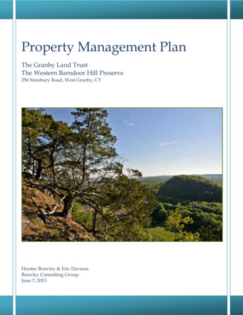
Property Management PlanThe Granby Land TrustThe Western Barndoor Hill Preserve256 Simsbury Road, West Granby, CTHunter Brawley & Eric DavisonBrawley Consulting GroupJune 7, 2013
TABLE OF CONTENTSINTRODUCTION . 1A. Site Description . 2B. Acquisition History . 3C. Abutters . 3D. Restrictions and Conditions. 3E. Conservation Values . 3STEWARDSHIP GOALS FOR THE PRESERVE. 4SITE CHARACTERISTICS . 4A. Natural Resources . 41. Topography . 42. Geology & Soils . 43. Hydrology . 64. Upland Plant Communities . 65. Wetland Plant Communities . 76. Wildlife & Critical Habitats . 8B. Cultural & Historical Resources . 9C. Current Use and Management . 9MANAGEMENT ISSUES. 9A. Boundary Posting & Signage . 9B. Access and Parking . 9C. Trail Maintenance / Improvements . 9D. Critical Habitats . 10MANAGEMENT RECOMMENDATIONS . 10A. Boundary Posting & Signage . 10B. Access and Parking . 10C. Trail Maintenance / Improvements . 10D. Critical Habitats . 10IMPLEMENTATION. 11APPENDIX A – AERIAL PHOTOGRAPH . 12APPENDIX B – TOPOGRAPHIC MAP . 13APPENDIX C – SOILS MAP . 14APPENDIX D – SITE FEATURES MAP . 15APPENDIX E – ROAD MAP . 16APPENDIX F – GROUND PHOTOGRAPHS . 16APPENDIX G - PREPARER’S QUALIFICATIONS. 24Table 1 – Permitted and Prohibited Activities on The Western Barndoor Hill Preserve . 4Table 2 – Soils within the Western Barndoor Hill Preserve . 5ATTACHMENT A – Property Survey Map . IN SLEEVEATTACHMENT B – Property Deed . IN SLEEVEATTACHMENT C – Natural Diversity Database Resonse letters . IN SLEEVE
INTRODUCTIONThe purpose of this plan is to guide the future management and use of Granby Land Trust’s WesternBarndoor Hill Preserve located on Simsbury Road in Granby, Connecticut. This plan describes the currentconditions and natural resources of the property and recommends an effective management strategy to protectnatural habitats for plants and wildlife while expanding the property’s public recreational uses. This is intended tobe a “living document” that is revised or amended over time as new information becomes available and/or as siteconditions change. This plan will help the Granby Land Trust (GLT) achieve its mission and stewardshipobjectives by: (1) identifying the site’s conservation values; (2) identifying potential threats to those conservationvalues; and (3) proposing a stewardship strategy which is commensurate with the Trust’s capacity to implementthe plan. Site visits to collect field data for this report were conducted in May, 2013.Fig. 1. Protected Open Space within the vicinity of the Western Barndoor Hill PreserveThe 32.7 acre Western Barndoor Hill Preserve in southern Granby was deeded to Granby Land Trust,Inc. (GLT) by Barndoor Hills Development LLC Development (BHD) on November 12, 1999 (Vol. 236, p. 798).The Preserve is located within an expansive greenway of undeveloped forest and farmland in southern Granbywhich includes GLT preserves and conservation easements, Town of Granby open space and the 4300 acreMcLean Game Refuge (See Fig. 1). To the north is GLT’s Cunningham Easement (Valkyrie Equestrian Center),Nuckols Preserve and 60-acre Holcomb Hill Preserve. To the east and west is the McLean Game Refuge. Thissection of Granby, which contains three distinct trap rock ridges, has been identified as a “Primary ConservationBrawley Consulting Group1Western Barndoor Hill Management Plan
Area” in the Farmington Valley Biodiversity Project prepared by Gruner et al. in 2006 (See Fig. 2)). That reportstates that: “Six of the primary habitat areas are associated with the intrusive traprock ridge ecoregion that extendsalong the western edge of the Farmington River valley. “The Knolls,” “Barndoor Hills West,” and “BarndoorHills East” are three clustered traprock knolls located in the southern section of town. Large sections of theseareas are owned and managed by the McLean Game Refuge. All three of these sites are extensively forested and ahigh percentage of the breeding bird community associated with these sites is composed of forest-interiordependent species. A number of raptor species including the northern goshawk (Accipiter gentilis) reside withinthese sites. All three sites also feature a diversity of significant natural communities associated with traprockridges including talus slopes, rocky outcrops and summits, and cliffs. These, in turn, host an array of rare plants.These sites along with other intrusive traprock ridge sites extending to the south in Simsbury and Canton supportthe only known Connecticut occurrences of the long-leaved bluet (Houstonia longifolia).”The Connecticut Department of Energy & Environmental Protection’s (DEEP) Natural DiversityDatabase (NDDB) program catalogs all current documented records of federally listed species, state-listedendangered, threatened or special concern species and significant natural communities. The most recent NDDBmapping of the preserve (NDDB digital layer, June 2012) dated December, 2012 indicates numerous NDDBrecords overlap the site in addition to the two significant natural communities discussed in the Wildlife & CriticalHabitats Section of this report. A NDDB application was submitted to the DEEP on May 15, 2013 for moreinformation regarding these records. Their response letters are in Appendix G.A. Site DescriptionLocated between Simsbury Road and BarndoorHills Road near the Granby/Simsbury town line, the32.7 acre preserve encompasses Western BarndoorHill, one of several traprock ridges in the area.Bordering the preserve to the east and west are tworesidential subdivisions: Kettle Pond Lane and BlackOak Drive. There is an established hiking trail leadingfrom Kettle Pond Lane to an overlook on the east faceof Western Barndoor Hill. The top of the hill offers 360degree views of the area described by the HartfordCourant (2/13/2009) as “Some of the most incredibleviews in the state.”The preserve falls within the West BranchSalmon Brook sub-regional watershed of theConnecticut River major basin. The preserve isunderlain primarily by rock-outcrop complex but alsocontains over 4.5 acres of wetlands and 2.5 acres ofFarmland of Statewide Importance. The site containstwo vegetation communities, Dry Subacidic Forest andSubacidic Rocky Summit Outcrop, which are identifiedas “Critical Habitats” by the CT DEEP. A variety ofrare plants have been identified within these criticalhabitats on Western Barndoor Hill. At the base of thehill bordering Kettle Pond Lane is a potential vernalpool.Brawley Consulting GroupFig. 2. Granby Biodiversity Map showing WesternBarndoor Hill in a “Primary Conservation Area”2Western Barndoor Hill Management Plan
B. Acquisition History256 Simsbury Road: 11/12/99, 32.669 acres, Barndoor Hills Development to GLTC. AbuttersIdentify as neededD. Restrictions and ConditionsE. Conservation ValuesThe Western Barndoor Hill Preserve has significant conservation value due to the following: The preserve encompasses a traprock ridge, which are known to support rare plants and animalsOver 4.5 acres of wetlands including a potential vernal poolOver 2.5 acres of Farmland of Statewide ImportanceTwo Connecticut “critical habitats” and numerous State-listed species in and around the preserveProximity to other large tracts of protected open spaceA public recreational trail that provides stunning views of Eastern Barndoor Hill and McLeanGame RefugeBrawley Consulting Group3Western Barndoor Hill Management Plan
STEWARDSHIP GOALS FOR THE PRESERVEA primary goal for the future management and use of all Granby Land Trust’s preserves is to fulfill theorganization’s mission: “The Granby Land Trust works to preserve Granby’s Natural Heritage through theconservation of its scenic vistas, open space corridors, wildlife habitat, ecologically sensitive areas, andagricultural lands.”The primary stewardship goal identified for the Western Barndoor Hill Preserve is to protect sensitivewildlife and plants while maintaining passive recreational uses of the property.Permitted and prohibited activities within the property are listed in Table 1.Table 1. Permitted and Prohibited activities in the Western Barndoor Hill PreserveActivityHikingBirdwatching/nature studyX/C SkiingPicnickingCamping / FiresFishing (catch-and-release)HuntingMechanized VehiclesHorseback RidingMountain BikingPERMITTEDXXPROHIBITEDXXXXXXXXSITE CHARACTERISTICSA. Natural Resources1. TopographyThe preserve encompasses the crest of Western Barndoor Hill and a portion of its steep eastern and westernslopes. The Barndoor Hills are part of a line of small traprock ridges in Granby running parallel to theMetacomet Ridge that extends from Branford, Connecticut to central Massachusetts. The property rangesfrom an elevation of roughly 650' Above Sea Level (ASL) on the crest of the hill to 350' ASL alongSimsbury and Barndoor Hill roads.2. Geology & SoilsThe Preserve is on the contact between two bedrock formations: Buttress Dolerite, which is dark-gray,brown- to gray-weathering dolerite (traprock); and New Haven Arkose. The surficial material is glacial tillthroughout the majority of the site and talus on the very steep eastern face of the hill. According to the 2007USDA Soil Survey Geographic (SSURGO) database for Hartford County, the site contains seven soil typesincluding three wetland soils and three soils which are Farmland of Statewide Importance (See Table 2).Although the coarse SSURGO database has mapped 7 acres of wetland within the Preserve, on-site wetlandmapping by a soil scientist (shown on survey map by Ed Lally) indicates there are 4.5 acres of wetlands(0.65 in eastern wetland and 3.9 in western wetland). Soil types consist of upland (non-wetland) soils ofthe Hinckley, Holyoke and Wethersfield soil series. Wetland soils consist of the Wilbraham and Menlocomplex, the Scitico, Shaker and Maybid complex and Raypol soil series.Brawley Consulting Group4Western Barndoor Hill Management Plan
Upland Soils (28 acres)The Hinckley series consists of very deep, excessively drained soils formed in water-sorted material(outwash). They are nearly level to very steep soils on terraces, outwash plains, deltas, kames, and eskers.The soils in this series are shallow to sand and gravel (12 to 30 inches).The Holyoke series consists of shallow, well drained and somewhat excessively drained soils formed in athin mantle of till derived mainly from basalt and red sandstone, conglomerate, and shale. They are nearlylevel to very steep soils on bedrock controlled ridges and hills. Rock outcrops range from few to many. Hardbedrock is typically present within the upper 20 feet.The Wethersfield series consists of very deep, well drained loamy soils formed in dense glacial till onuplands. The soils are moderately deep to dense basal till. They are nearly level to steep soils on till plains,low ridges, and drumlins. Permeability is moderately rapid or moderate in the solum and slow or very slowin the dense substratum. Slope ranges from 0 to 35 percent.Wetland Soils (4.5 acres)The Raypol series consists of very deep, poorly drained soils formed in loamy over sandy and gravellyglacial outwash. They are nearly level to gently sloping soils in shallow drainageways and low-lyingpositions on terraces and plains. The soils have a water table at or near the surface much of the year.The Scitico series consists of very deep, poorly drained soils formed in silty and clayey sediments. They arenearly level to very gently sloping soils in low-lying positions of glaciolacustrine and marine terraces.Scitico soils have a water table at or near the surface much of the year.The Shaker series consists of very deep, poorly drained soils formed in loamy over clayey sediments. Theyare nearly level to gently sloping soils in low-lying positions on glaciolacustrine and marine terraces. Shakersoils have a water table at or near the surface much of the year. Typically, these soils are in low-lying broad,flat, or slightly concave areas.The Maybid series consists of very deep, very poorly drained soils. They are nearly level or level soils onlowlands. Slope ranges from 0 to 3 percent. The soils formed in water deposited material of marine orlacustrine origin. Internal drainage is very slow. Permeability is slow or very slow. The soil is intermittentlyponded or has very slow runoff.Table 2. Soils within the Western Barndoor Hill Preserve (SSURGO database)Soil NameWetland SoilsHinckley gravelly sandy loam, 3 to 15 percent slopesFarmland SoilsFarmland of Statewide ImportanceAcreage0.39Holyoke-Rock outcrop complex, 3 to 15 percent slopes0.94Holyoke-Rock outcrop complex, 15 to 45 percent slopes8.25Raypol silt loamXFarmland of Statewide ImportanceRock outcrop-Holyoke complex, 3 to 45 percent slopes1.0510.94Scitico, Shaker, and Maybid soilsXFarmland of Statewide Importance0.96Wethersfield loam, 3 to 15 percent slopes, extremely stony0.77Wethersfield loam, 15 to 35 percent slopes, extremely stony3.62Wilbraham and Menlo soils, extremely stony* Wetland soils are in redBrawley Consulting GroupX55.69Western Barndoor Hill Management Plan
The Wilbraham series consists of poorly drained loamy soils formed in subglacial till. The soils are verydeep to bedrock and moderately deep to a densic contact. They are nearly level to gently sloping soils indrainageways and low-lying positions of till hills. Wilbraham soils have a water table at or near the surfacemuch of the year. They have an aquic moisture regime.The Menlo series consists of very poorly drained loamy soils formed in subglacial till. They are very deep tobedrock and moderately deep to a densic contact (hardpan). They are nearly level soils in depressions anddrainageways of till covered plains and hills. Depth to bedrock is commonly more than 6 feet. Menlo soilshave a water table at or above the surface most of the year (i.e., the soil may be ponded).Of these soils, 2.5 acres are classified as Farmland of Statewide Importance (See Soils Map, Appendix C).Farmland of Statewide Importance are soils that fail to meet one or more of the requirements of primefarmland, but are important for the production of food, feed, fiber, or forage crops. They include those soilsthat are nearly prime farmland and that economically produce high yields of crops when treated and managedaccording to acceptable farming methods.3. HydrologyThe preserve falls within the West Branch Salmon Brook (Basin #4319) sub-regional watershed of theConnecticut River major basin. There are two distinct wetlands on the property bordering Simsbury Road tothe west and Barndoor Hills Road to the east. There are no mapped streams on the property, but there is anintermittent watercourse.4. Upland Plant CommunitiesThe low and mid-slope forest community consists of mesic, mixed hardwood forest. The higher elevationsof the preserve, at an approximate elevation above 464 feet ASL (Above Sea Level), consists of tworegionally rare ridgetop plant communities: (1) dry sub-acidic forest, subtype Ash/Hickory glade; and (2)sub-acidic rocky summit outcrop, sub-type cedar woodland.These rare habitat types have been identified and mapped as “Critical Habitats” by the CT DEEP.Connecticut’s Critical Habitats mapping depicts the classification and distribution of 25 rare and specializedwildlife habitats in the state. It represents a compilation of ecological information collected over many yearsby state agencies, conservation organizations and individuals. These Critical Habitats represent a subset ofimportant wildlife habitats identified in the Connecticut Comprehensive Wildlife Conservation Strategy(CWCS).Mixed Mesic ForestThe mesic, mixed hardwood plant community consists of mature second-growth forest, with scattered largesawtimber ( 14 d.b.h.) present. Tree species include black oak (Quercus velutina), white oak (Quercus alba),tulip (Liriodendron tulipifera), sugar maple (Acer saccharum), black birch (Betula lenta) and hickory (Caryaspp.). There are small inclusions of conifer trees consisting of white pine (Pinus strobus) and easternhemlock (Tsuga canadensis). The understory vegetation includes lowbush blueberry (Vacciniumangustifolium), christmas fern (Polystichum acrostichoides) and hay-scented fern (Dennstaedtiapunctilobula).Dry sub-acidic forest, sub-type Ash/Hickory GladeThis plant community type consists of slow-growing forest located primarily on or near the summit of basaltor other mafic rock ridges and is often dominated by white ash (Fraxinus americana), hickories (Caryaglabra, C. ovalis, C.ovata), hophornbeam (Ostrya virginiana) and sugar maple (Acer saccharum), with fewBrawley Consulting Group6Western Barndoor Hill Management Plan
shrubs and an open grassy ground cover. Soils are either acidic or circumneutral (Metlzer and Barrett, 2006).Tree height is low in stature and the sporadic shrub layer, combined with an herbaceous layer oftendominated by grasses and sedges (Carex pennsylvanica often dominant) gives this habitat a park-likeappearance (Metlzer and Barrett, 2006). This habitat supports a variety of uncommon to rare herbs,wildflowers and spring ephemerals including tick trefoils (Desmodium spp.), whorled milkweed (Asclepiasverticillata), rock-cress (Arabis spp.) as well as a variety of ferns including ebony spleenwort (Aspleniumplatyneuron) and woodsia (Woodsia obtusa). Spring ephemerals include early saxifrage (Saxifragavirginiensis), Virginia spring beauty (Claytonia virginica), common blue violet (Viola sororia) and dogtoothviolet (Erythronium americanum) (Metlzer and Barrett, 2006).This habitat type was identified and mapped at the preserve in 2002 during the FVBP. The FVBPdocumented the area as being in excellent condition and indicated that this was the only Connecticutoccurrences of the long-leaved bluet.Sub-acidic rocky summit outcrop, sub-type cedar woodlandThis plant community type consists of dry to xeric exposed summits, ledges, and other outcrops (primarilybasalt and other mafic rocks) with a vegetation of low shrubs, grasses and herbs. Eastern red cedar(Juniperus virginiana) with white ash and hickories are the dominant tree species. Rare species noted includelong-leaved bluet, balsam groundsel (Senecio pauperculus), fuzzy wuzzy sedge (Carex hirsutella), greenrockcress (Arabis missouriensis), cankerweed (Prenanthes cf. serpentaria), Bicknell’s sedge (Carexbicknelli) and blue sedge (Carex glaucodea).Mapping of this habitat type during the FVBP indicated that this habitat type had very recently grown from acedar glade and is transitional to an ash-hickory glade. The FVBP also indicated that the habitat was ingenerally excellent condition.5. Wetland Plant CommunitiesTwo wetlands occur on the preserve, one at the eastern end south of Kettle Pond Lane and the second at thewestern end bordering Simsbury Road. Both wetlands are classified as “palustrine forested wetlands”, or“wooded swamps”.The western wetland is classified hydrologically as a “groundwater slope wetland”. Groundwater slopewetlands are wetlands that develop on hillsides or slopes where groundwater discharges to the surface assprings or seeps.The eastern wetland is classified hydrologically as a “groundwater depression wetland”. Groundwaterdepression wetlands occur in depressions that are topographically low enough to intercept the localgroundwater table; these wetlands also receive overland flow from the surrounding uplands. This wetlandreceives flow directly from an intermittent watercourse flowing from the hillside northwest of the wetland.This watercourse flows across the main trail that leads to the summit.The eastern wetland also has hydrologic characteristics indicating it may function as a vernal pool (e.g.,sparsely-vegetated concave depression). When observed during our field survey on May 17, 2013, the poolwas completely dry, demonstrating a hydrologic regime which would not allow for the full development andmetamorphosis of vernal pool obligate species (e.g., spotted salamander, wood frog) to occur. This mayindicate that the pool has a marginally suitable hydrology with respect to amphibian productivity. However,given the lack of rainfall present this spring, it is difficult to draw conclusions on the suitability of thiswetland for vernal pool species based on the limited field work conducted in conjunction with this report.Brawley Consulting Group7Western Barndoor Hill Management Plan
Wetland vegetation in both wetlands is similar in nature and is typical of wooded swamp wetlands in theregion. The tree canopy is dominated by red maple (Acer rubrum) with green ash (Fraxinus pennsylvanica)also occurring. The shrub layer includes multiflora rose (Rosa multiflora), spicebush (Lindera benzoin),Japanese barberry (Berberis thunbergii), escaped/naturalized Japanese maple (Acer palmatum, westernwetland only) and winterberry (Ilex verticillata). The herb layer includes cinnamon fern (Osmundacinnamomea), sensitive fern (Onoclea sensibilis), marsh fern (Thelypteris palustris), royal fern (Osmundaregalis), brambles (Rubus sp.), tussock sedge (Carex stricta), marsh bedstraw (Galium palustre), jack-in-thepulpit (Arisaema triphyllum), poison ivy (Toxicodendron radicans) and jewelweed (Impatiens capensis).6. Wildlife & Critical HabitatsThe Western Barndoor Hills Preserve is located within the Western Highlands ecoregion of the FarmingtonRiver Valley and was designated as a “Primary Conservation Area” in the Farmington Valley BiodiversityProject (FVBP hereafter, Gruner, et. al., 2006). The FVBP provides the following description of Granby’straprock ridge ecosystem in which the Preserve is located:The traprock ridge ecoregion extends up through the (Farmington) river valley and includes the Metacometridge system that runs along the eastern edge of the river valley and the intrusive ridge system that runs alongthe western edge of the valley. These unique geological features composed of erosion resistant basalt fromancient lava flows harbor a wide range of important natural communities such as talus slopes and cliffs, baldrocky summits, perched vernal pools and large tracts of contiguous forest. These habitats contributesignificantly towards the region’s biodiversity. Wildlife species such as the five-lined skink (Eumecesfasciatus), Connecticut’s only lizard, and the northern copperhead (Agkistrodon contortrix mokasen), arerestricted to traprock ridge habitats in this region. These ridge systems also function as natural corridors andrefugia for migratory birds and large mammals such as the bobcat (Lynx rufus) and black bear (Ursusamericanus). Many rare plants are located within traprock ridge communities. For example, the onlyConnecticut occurrences of the long-leaved bluet (Houstonia longifolia) are found here.The potential vernal pool (from the Latin vernalis, meaning spring) bordering Kettle Pond Lane is also acritical habitat that may support sensitive amphibian and reptile species. Vernal pools are ephemeralwetlands which by definition are typically only saturated during the spring of the year, lack any definedoutlet, are devoid of fish and contain one or more obligate breeding species such as wood frogs (Ranasylvatica) or spotted salamander (Ambystoma maculatum). Many of the species associated with vernal poolsare threatened in the Northeastern United States because these pools are difficult to identify and theirconservation requires protection of large tracts of surrounding forest. Guidelines for the conservation ofvernal pools recommend maintaining 100-750 ft. (from spring high water) of “critical terrestrial habitat”around all vernal pools. According to Conserving Pool-Breeding Amphibians in Residential and CommercialDevelopments in the Northern United States (Metropolitan Conservation Alliance) “this area provides habitatfor amphibians during the non-breeding season for foraging, dispersing, and hibernating. During the breedingseason, adults migrate to pools through this zone.”When viewed at a landscape scale, the region in which the preserve is located is heavily forested and capableof providing breeding habitat for a variety of avian species including forest-interior bird species. The siteitself, however, may represent suboptimal habitat for forest-dwelling birds due to its small size and proximityto non-forested habitats including residential development, farmland and roads. However, as part of aridgeline ecosystem, the site likely functions as a migratory corridor offering stopover habitat for birdstraveling through Connecticut’s Central Valley. During the peak spring migration period in May 2013, we Denotes invasive, non-native plant speciesBrawley Consulting Group8Western Barndoor Hill Management Plan
observed several neo-tropical migrants including the yellow-throated vireo (Vireo flavifrons), Americanredstart (Setophaga ruticilla), eastern wood pewee (Contopus virens) and pine warbler (Setophaga pinus).B. Cultural & Historical ResourcesUnknown – needs to be researchedC. Current Use and ManagementThere is an existing trail on the property that leads from Kettle Pond Lane to the top of Western BarndoorHill. GLT has a contractor mow the accessway that runs along the south side of Kettle Pond Lane to the trailhead.MANAGEMENT ISSUESDuring field surveys several primary management issues were identified for the Western Barndoor HillPreserve. The primary management goal is to protect the site’s “critical habitats” and rare
The purpose of this plan is to guide the future management and use of Granby Land Trust's Western Barndoor Hill Preserve located on Simsbury Road inGranby, Connecticut. This plan describes the current conditions and natural resources of the property and recommends an effective management strategy to protect