Transcription
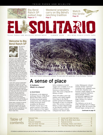
TEXASPARKSANDWILDLIFEBig BendRanch SPpullout mapWeekend wranglerscarry on Big Bend’sranching traditionPages 6 — 7Page 3Watchthe birdiePage 10el SOLitarIoTEXAS PARKS AND WILDLIFE DEPARTMENT SUMMER 2008 B I G B E N D R A N C H STAT E PA R KWelcome to BigBend Ranch SPMy name isRodrigoNavaretteTrevizo. It is anhonor beyondmeasure to beasked to leadthe largest statepark in Texas.Although I have hiked and campedin many of our beautiful stateparks and state natural areas, theBig Bend is where my heart andsoul belong. This is a country ofbeauty and isolation, ruggedcanyons, hidden springs andincredible vistas. Its people arestrong and hardworking and itsculture unique. Within the park’sfascinating history, one that spansalmost 400 years, you will find thestory of not only the Trans Pecosbut of the entire state of Texas. Infact, the park has been a cross roads of human activities for over11,000 years!I work with a group of dedicatedemployees charged with imple menting our public use plan. Thisambitious plan will make the park’sremote campsites and extensivetrail system available to the peopleof Texas and visitors from aroundthe world. We are working toexpand our partnerships andoutreach programs, to bring thepark’s cultural and naturalhistories to an ever expandingaudience, and to secure its place ofimportance in our natural world.Please take a moment to perusethis issue of El Solitario andfamiliarize yourself with all thepark has to offer. I truly believethat you will be as excited as I amabout the future of Big BendRanch State Park.Table ofcontentsAerial view of Solitario looking north northeast. The lower outer rim’s upside down V’s are the famous “Flatirons.”A sense of placeEl Solitario:What’s In a Name?by David RiskindEl Solitario is the signaturelandscape feature of Big BendRanch State Park. Almost10 miles across and nearlysymmetrical, this collapsed anderoded structural domestraddles the Brewster Presidio County line in theeastern portion of the park.Early explorers of the regionnoted its distinctive shape evenbefore airplanes or aerialimages were available. It is oneof Earth’s more distinctivefeatures as observed fromspace. The name is Spanish forhermit or loner.About 36 million years agomolten rock called magmafrom deep in the Earthpushed upward and displacedthousands of feet of overlyingrock. This activity created ablister or dome shaped bulgeon the Earth’s surface. Overmillions of years, erosioncollapsed the dome’s olderFeatured Trails. . . . . . . . . . . . . . . . . . . . . . . . . . . . . 2Be Aware . . . . . . . . . . . . . . . . . . . . . . . . . . . . . . . . . 3Featured Campsites . . . . . . . . . . . . . . . . . . . . . . . . 4Fees and Visitor Services . . . . . . . . . . . . . . . . . . . 5Big Bend Ranch Map . . . . . . . . . . . . . . . . . . . . . . . 6rocks. Subsequent volcanicactivity further removedoverlying rock, collapsed someof the lava chamber andformed a small caldera in thecentral southeast Solitario.Early geologic studieserroneously suggested thatthe Solitario was either alarge volcano or a meteorimpact crater.The Solitario, as we see ittoday, emerged about 2 millionyears ago when the ancient RioGrande began cutting its nowContinued on page 10Access and Visitor Services . . . . . . . . . . . . . . . . . 8What To Do While You’re Here . . . . . . . . . . . . . . . 9Featured Activity. . . . . . . . . . . . . . . . . . . . . . . . . . 10Archeology, History and Culture . . . . . . . . . . . . . 11“The River Road Runs Through It”. . . . . . . . . . . 12El Solitario is published twice per year by the Texas Parks and Wildlife Department for the orientation and education of visitors to Big Bend Ranch State Park.
Featured Trails:Encino Hikingand Biking TrailClosed Canyon TrailA group of middle and high school students meander through low hills,ocotillo forests and along ancient streambeds on the Encino Loop Trail.The Encino Loop Trail, locatedin the interior of Big BendRanch State Park, follows anold jeep trail nearly nine milesthrough a remote portion ofthe Encino Pasture. This wide,easy to follow trail offers oppor tunities for hiking and mountainbiking, birding and photography.An easy hike and a moderatelystrenuous mountain bikingexperience, the trail offers greatviews of ancient lava domes,rugged mesas and colorfuldesert vegetation.During the spring and earlysummer, look for the desertwildflowers that decorate theharsh landscape. Be alert forjavelinas rooting through thelechuguilla as you listen tothe songs of Black tailedGnatcatcher, Verdin and Black throated Sparrow. Pay closeattention to the animal tracksthat appear in sandy arroyobottoms and you just might seea coyote ambling away.The trail loop begins 1.5 mileseast of the Sauceda VisitorCenter at the junction ofCamino a la Sauceda and LaMota Road, just past the cattleguard. The first mile of thetrail follows La Mota Road, sowatch carefully for vehicles.Views include the shallow hillsof Leyva Canyon to the west,La Mota Mountain to thenorth, Fresno Peak to the eastand several volcanic domes tothe south. At 1.01 miles thetrail leaves the road and veersto the northeast.At two miles the trail entershilly terrain where canyonsdissect the landscape. Look forseverely distorted and twistedrock outcrops — evidence of thegeologic forces that have longshaped the region. At 3.0 to 3.5miles you will pass acres ofocotillo, a hardy plant alsoknown as desert candle.Papalote Encino (EncinoWindmill), the largest windmillat Big Bend Ranch, comes intoview at the four mile mark.Relics from decades of ranchingactivities litter the ground, par ticularly those associated withman’s attempt to harness waterin the desert.Between 4.2 and 5.0 miles thetrail veers to the right andfollows the main ranch road.Watch for vehicles. At 5.1 miles,enjoy an excellent view of LaPosta Mountain with FresnoPeak set as a lofty backdrop. At5.3 miles, the Encino trail leavesthe road once again andcontinues to the right. Aheadlies a commanding view of theLlano, a slightly depressed plainthat recharges the undergroundwater supply during the rainyseason. Travel along this routeis fairly easy — mostly level witha slight downhill dip.Between 6.1 and 7.5 miles thetrail continues through a seriesof arroyos and gullies. In one ofthe bigger arroyos, watch for alarge cluster of quartz crystalsthat resembles a mound of icecubes. At 6.8 miles the countrybegins to open back up, and at7.5 miles the trail changesdirection to the northeast. Becareful in these areas; manyarroyos are covered with loosesand and gravel.At 8.8 miles the route intersectswith La Mota Road. Turn to theleft and return to the beginningof the trailhead.2 el SOLitarIo Texas parks and wildlife departmentHikers on the Closed Canyon Trail walk through a slice of geologic history.The Closed Canyon Trailconstitutes perhaps the mostpopular hike along the River Roadcorridor at Big Bend Ranch. Thetrailhead is located approximately29 miles east of Presidio and 36miles west of Study Butte on FM 170 (The River Road) between LaCuesta (The Big Hill) and theColorado Canyon River Access.This relatively easy three mileround trip trail enters a slotcanyon that portrays the incrediblesculpting power of water anderosion. Deep inside the canyon,hikers can stretch out their armsand touch both canyon wallssimultaneously while looking up atthe canyon rim 150 feet above.Imagine the force required to slicethrough solid rock in this way!Closed Canyon Arroyo cutsthrough the reddish volcanic rockof Colorado Mesa. This mesa iscomposed of ash flow tuffs thaterupted from volcanoes in theSierra Rica of neighboringChihuahua, Mexico, about 30 – 28million years ago. Around2 million years ago, both ColoradoMesa and the Santana Bolson(the valley that the River Roadfollows) had become completelycovered with sedimentary basin filling rocks. As the ClosedCanyon Arroyo began to cutthrough these softer, looser rocksand establish its course, intenseerosion occurred quickly enoughto completely breach the harder,underlying volcanic rock ofColorado Mesa. Thus, ClosedCanyon Arroyo became a directtributary of the Rio Grande.Today, the Closed Canyon Trailpresents a meandering hike into anarrow, deep, high walled canyonworn smooth by the ongoingeffects of moving water andsediment. As you walk throughthe canyon and contemplate itsgeologic past, also look for one ofthe Big Bend’s most colorfullizards. The greater southwesternearless lizard can be seen alongthe canyon walls performing“push ups” to expose its blue purple belly to potential mates.During the mating season, malessport a vivid orange throat patchand a lime green wash along theflanks. Closed Canyon is also afavorite habitat for the canyonwren. Listen for its melodic song,a descending cascade of notes,echoing throughout the canyon.During summer it is best to avoidhiking Closed Canyon duringmid day when the sun is directlyoverhead. Morning or afternoonis better because the canyon flooris shaded by its high walls. Besure to carry plenty of water, andwear a large brimmed hat.Beware of afternoon thunder storms; flash flooding can be aserious problem in the canyon.To learn more about the geologyof the region, pick up a copyof Geology of Big Bend Ranch StatePark by Christopher Henry, atany of our visitor centers.
Mountain lionBe Aware:Head ‘em up,move ‘em out!You’re in wildlife countryWeekend wranglers have achance each spring and fall tosee cattle in the ranch’s ruggedMany wonderfulanimals live hereand play a vital rolein the balance ofNever feed wild animals orallow them to get human orpet food.and remote pastures, learnhow the herd is moved withhorses, and drive the park’sObserve wild animals andlonghorn cattle from a safedistance; never approach ortry to photograph them atclose range.historic Texas Longhorn Herdto stock pens at SaucedaHeadquarters. Participants cantake part in branding andnature. You are aKeep children and pets underyour control at all times.vaccinating calves, recordingguest in their home.Clean up and store food andgarbage immediately after meals;never keep food in your tent.traditions of the Spanish,By learning aboutthe park’s animalsand observing thefollowing tips, youcan show them therespect theydeserve whilekeeping yourselfand your family safe.lineages and experiencing theMexican and Anglo Americancowboy culture.Enjoy the outdoors withothers, not alone.In the unlikely event that youencounter a black bear ormountain lion, do not run.Instead, face the animal, makenoise and try to look as largeas possible. Pick up smallchildren. Back away slowly. Ifattacked, fight back. Reportsightings to park staffimmediately.Rattlesnakes are especiallycommon at Big Bend Ranch.Watch where you put yourhands and feet. Never harassor attempt to handle arattlesnake—this is when mostbites occur. Rattlesnakes areprotected in the park; do themno harm.The cattle drive is Big BendRanch State Park’s mostWestern Diamondback rattlesnakepopular program, allowing up to25 visitors to experience a partIn the unlikely event that abite occurs: Remove jewelry and loosentight fitting clothing. Wash the bite area withdisinfectant. Keep the person calmand quiet.of the state’s Western heritage.The three day event allows par ticipants to learn about thepark’s ranching tradition,experience life as a cowboy andgain a lifetime of memories. Limit movement if atall possible.For information call the Big Watch for symptomsof shock.Sauceda Ranger StationBend Ranch State Park,at (432) 358 4444. Seek medical attentionimmediately.big bend ranch state park el SOLitarIo 3
Featured Campsites:Fresno Vista CampsiteVolcanic boulders stand sentinelas they guard the approach toFresno Vista campsite. Here, atthe edge of ancient lava flowsfrom the Bofecillos volcanoes,one can glimpse millions ofyears of geologic history andcontemplate thousands ofyears of human occupationin upper Fresno Canyon.After driving through gentlyrolling grass covered hills toarrive at the campsite, visitorswill find a picnic table and firering situated in a small valley.A few yards to the north lies alevel ridgeline that has beendesignated for tent camping.Numerous tumbled bouldersinvite exploration and play. Thesite can also accommodatethose with mobility issues.What’s specialabout this site?Getting There Uninterrupted views of thesurrounding mountains So peaceful that youcan hear the breezepass through Lots of room to spread outFresno Vista campsite isprotected from south windsbut is exposed to the north.Desert grasses, lechuguilla,cholla, hedgehog cacti and anoccasional juniper are commonplants. On clear nights,stargazing is spectacular.From Sauceda Ranger StationSauceda Ranger Station to Fresno Vista Road 7.8 milesFresno Vista Road to water trough0.9 milesWater trough to campsite0.3 miles9 40milesminutesAt the Sauceda Ranger Stationturn right and travel east onCamino a la Sauceda, the 2WDall access road. Turn rightonto Fresno Vista Road. Passthe warning sign and travelalong the ridgeline. Uponreaching a water trough, turnright and follow the road tothe parking area.GPS Coordinates (NAD83)UTM13 EastingUTM Northing611335.27563263866.2950Longitude DDLatitude DD 103.8514018329.49939832Longitude DMSLatitude DMS 103 51 5.046629 29 57.8339Access: 2WD High ClearanceBackcountryZone CampingTascate 1 CampsiteFor decades, vaqueros andcowboys maintained the watertank and windmills of Tascate.Today the Tascate 1 campsiteoffers visitors a taste of thepast. Sit at the picnic table andsurvey the rugged hillsidescovered with yucca and sotol asyou ponder the site’s ranchingheritage and the natural beautythat lies all around.The picnic table and fire ringat this campsite are locatedapproximately 50 yards fromthe parking area. Nearby therock walls struggle to keepback the mariola and creostebush that is attempting to takeback the land. A large tent padis located northwest of the firering, and a smaller tent pad islocated northeast of thewindmill directly behind theparking area.Getting ThereTurn left at the SaucedaRanger Station and travel tothe Madrid Falls Road. Turnleft onto Madrid Falls Roadand follow the road south. Passthrough the closed gate andtravel through the Llano Flatsamong scores of yucca, purpleand green prickly pear cactusand stands of ocotillo.What’s specialabout this site? Solitude Elegant rock formationsand views A sense of protection foryour family and friendsGPS Coordinates (NAD83)UTM13 EastingUTM Northing599591.08713256303.3155Longitude DDLatitude DD 103.9732322329.43214196Longitude DMSLatitude DMS 103 58 23.636029 25 55.7111Access: 4WD High ClearanceFrom Sauceda Ranger StationSauceda Ranger Station to Tascate RoadTascate Road to Campsite3.1 miles1.5 miles4 el SOLitarIo Texas parks and wildlife department4.6 40milesminutesPass the intersections ofLlano Loop and PapaloteLlano. Take in breathtakingviews of Fresno Peak and theChisos Mountains. Turn rightat the intersection of MadridFalls and Tascate Road.Engage four wheel drive andnegotiate through water erodedchannels traveling south westerly. Enter the open gateand follow the road through asmall oval depression into thecanyons below Tascate Peak.Cross the arroyo and enterthe heavily vegetated canyonbottom. Pass the remains of thehistoric wooden windmill andpull into the parking area nearthe water trough.There are no designatedcampsites in the backcountryzone. Backcountry campingallows overnight visitors toselect their own primitivecampsite, based uponcertain conditions: At least 1/4 mile from anyother existing campsite At least 300 feet from watersources and prehistoric orhistoric cultural sites At least 3/4 mile fromtrailheads or roadsBackcountry campers may usethe “cathole” method to disposeof human waste and must packout all trash. No open fires areallowed due to resource impact;use of containerized fuel stovesis permitted. The maximum stayis 14 nights (total) and sevenconsecutive days in any onebackcountry zone.
Big Bend Ranch State ParkFees and visitor servicesDaily entry fee: 3 per person perday for all 13 yearsand olderThe viewing or reviewingof comprehensiveorientation materials andinformation is required.This material willintroduce the park, theChihuahuan Desert,safety, water use, vehiclerequirements, land ethics,etc. Orientation isrequired annually.Horses: 2 per day/horseLodgingBig Bend Ranchpaved airstrip 3TE3103 56 11.7030 W28 28 10.6840 NElevation: 4240 feetLength: 5500 feetFront Country ZoneDay Use OnlyPrimitive Road orBackcountry ZoneDay or Overnight UseBackcountryZone Camping: 5 per night/siteAirstripOrientationAppropriate orientationmaterials will beprovided, depending onthe visitor’s intendedactivities and areas ofinterest at the park.Standard VehicleCampsite: 8 per site/dayLodging is available bunkhousestyle or in the “Big House” atSauceda. Meals are availablewith advance reservations. Call(432) 358 4444 between 8:00a.m. and 5:00 p.m. for informationand reservations.Important:Park Information and PermitsPark information and permits for day use and camping may be obtained inperson from 8:00 a.m. — 4:30 p.m. daily at three locations:Sauceda Ranger StationPark interior(432) 358 4444No gas, dieselor groceriesavailable in park.Barton Warnock EnvironmentalEducation CenterLajitas(432) 424 3327Fort Leaton StateHistoric SitePresidio(432) 229 3613Special use permits are required for use of Primitive Road and all camping.Day Use visitors are required to obtain a free, special use permit formotorized use of primitive roads.Campsite and backcountry reservations may be made in advance by calling(432) 358 4444 between 8:00 a.m. and 4:30 p.m. Permits must be pickedup in person.Use ZonesFront Country Zone is defined as those lands within approximately one quarter mile either side of the designated 2WD roads. All street legal andlicensed vehicles are permitted in this zone. Overnight use may occur onlyat designated campsites, with the required, special use permit.Cell phone service inthe park is verylimited and unreliable.Don’t count on it!Emergency dial 911TowingAlpine (432) 837 1150Presidio (432) 229 3312Primitive Road Zone is defined as lands within one quarter mile eitherside of designated 4WD or 2WD high clearance roads. Motorized vehicleaccess to this zone is restricted to street legal and licensed vehicles thatmust have at least four functional wheels. Overnight use may occur only atdesignated campsites, with the required, special use permit.Backcountry Zones are defined as lands that are more than one quartermile from publicly accessible roads. Twenty separate zones have beendefined. Only non motorized travel is permitted. Visitors are encouraged,though not required, to use designated trails and routes until they areknowledgeable and confident enough in their familiarity with the park totravel cross country.big bend ranch state park el SOLitarIo 5
169CieenCienega CamplacgakHilMolsuantinsCasaPiedraState ParkTaLa Viuda4080scotSan Jacinto Mountain4965Cerro Boludo4740alBanMdeseaBig Bend ranchThe DikeHighwayTrailsBackcountry Ranger ResidenceGradedCounty4-Wheel Drive - Unmaintained4-Wheel Drive2WD High ClearanceTrailheadsRiver AccessCampgroundEquestrian Staging CampsiteGroup CampsiteCampsiteLegendRed Hill4054cCcesPtMenieokeaeeaArenC igsangdisicb lPurC reek
mAlaasCTcl an e re rBPRs170RedfordkC r e eoBrofeca1234Miles5raossnCanynonBofecillos Peak5002ourrdCerro de las Burras4345BaesCaOsoRancherias West Trailhead10Las Burras 1Oso Mountain(Highest Point in Park)5135Guale 2Las Burras 2Las Burras 3Guale TrailheadCayoLos Ojitoso lo ra doC an yo nClosed Canyon TrailheadsCJavalinrr3TE3knilMadera CanyonLa CuestaoLa MonillaVista del ChisosAMexicano 2rroyoFresno VistaFresno Peakan dht HiChorro VistaMexicano Falls TrailheadRincon 2Rincon 1iguFresno PeakRtS huSolitario Peak4786m e roGrassy BanksEagle Mountain4819HaupLajitasBarton Warnock Enviro Ed CenterTres Cuevas MountainBlack MeMasada RidgeWilderness Unit(BBR State Park)Amarilla Mountain3013Barton Warnock TrailheadContrabando Mountain3214ContrabandoWax Factory Laccolith3139ftutTres PapalotesLendShTres Papalotes TrailheadPaso al SolitarioS o l i t a r i oNeedle Peak4608T h ePila Montoya 3Pila Montoya 2Burnt Camp TrailheadJackson PensLos AlamosLos Alamos ResidencePor tal del Nor tePila Montoya 1Fresno Canyon TrailheadPila de losMuchachosMadridFallsLosHermanosFallssx ioc a nMexicanoM eRincon MountainPuerta Chilicote TrailheadLa Posta Mountain4630La PostaPapalote Nuevoo o drreA yl o sJavalin PensPapalote LlanoMexicano 1Pila Montoya TrailheadPapalote EncinoeOjo EscondidoePapalote Llano NuevoSauced aSouth LeyvaEscondido PensEscondidoLa Mota 2oJavalin TrailheadRancheriasPanther Mountain4922Tascate 1Los CuatesGuale 1rLeyva TrailheadeCinco Tinajas TrailheadRancherias East TrailheadCnnnPapalotito ColoradoYedra 1Yedra 2Nopalera TrailheadAgua Adentro Mountain4938Agua Adentro PensOjitoAdentroOjito Adentro TrailheadColorado CanyonArenosaLas Burras TrailheadCyYedra TrailheadrLa Mota Mountain5046eo n0Private PropertyullnPapalote Rancho ViejoRancho Viejo TrailheadVista del BofecillosBotella ResidenceTMTrail or RoadiADisclaimer:Property boundaries are for representation only.Not all private property is shown on map. Visitorsshould not trespass on private property. Map doesnot depict all trails and roads. Additional trails androads depicted for informational and wayfindingpurposes only.i - Ft. Leaton4 milesdaiePar k Entrance- Por tal de PresidionnoyC re eknl si lsaLnaCoyHnakRadC a n yCnoynaCnRoPrasairehcsealoC y n .nlanCndo nn yGayoTa p a d ooaCC aorpnyn t hesPopaeut uevrShLyFL o w erg
Big Bend Ranch State ParkAccess and visitor servicesVehicle AccessibleCampingFifty five locations have beendesignated for vehicle accessiblecamping. Permits are required.Each site includes a tent area,picnic table and fire ring. Somecampsites are still underdevelopment and may temporarilylack some amenities.Campers are required to placetents in designated areas only.Desert resources are fragile.Important: All visitors arerequired to haul out their humanwaste and pack out all trash.Portable privies are available forpurchase at all permit issuingstations.Downed wood is critical to desertecology. Gathering firewood isprohibited. Visitors may bringtheir own firewood or purchase itat Sauceda. Charcoal cooking firesand containerized fuel stoves areallowed. Ashes must be packedout or deposited in the fire ring.The maximum stay per permit is14 nights.Individual Campsites Up to 8 person occupancy 3 vehicle limitGroup Campsites Up to 12 person occupancy 5 vehicle limitCampsites at CampgroundsRoad conditions are affected by rain and runoff and willvary widely. Check with a ranger for conditions on arrival.Know Your VehicleSome roads are suitable only for high clearance or four wheel drivevehicles. If you have any questions about the roads or the suitability of yourvehicle, consult a park ranger. Two wheel drive (2WD): main road and some spurs that any highway worthy vehicle, driven responsibly, can access. Two wheel drive, high clearance (2WDHC): roads where extra clearanceis required due to road conditions (rocks, steep dips, etc.). Four wheel drive (4WD): recommended where extra traction is requiredon steep, loose or soft ground. Includes all wheel drive (AWD). Four wheel drive, high clearance (4WDHC): primitive roads or routesharsher then 4WD, where passage requires vehicles with extra traction,rigid suspension and high clearance.High clearance is considered a minimum of 8 inches.Rules for the Road Less TraveledPark roads are dirt and may be narrow. Speed limit is 25 mph on primarypark roads. Drive slowly to keep yourself, your passengers, your vehicleand the park’s animals safe. 3 vehicle limitWhen should 4WD be engaged? Generally speaking, once you leave themaintained road, shift from 2WD into 4WD and leave it there untilreturning to the maintained road. Use 4WD low before you need tonegotiate any really difficult obstacles.PetsPets are allowed anywhere vehiclesare allowed, and within 1/4 mile ofpublicly accessible roads. Alwayskeep pets on a leash and pick up afterthem. Never leave pets unattended orallow them to approach wild animalsor longhorn cattle. The lodge at Sauceda is abunkhouse with a commercialkitchen. Meals are prepared andserved in a common dining area.Meal service can be arrangedwith advance notice. Lodging isavailable bunkhouse style withmen on one side and women onthe other. The three bedroom “BigHouse” sleeps eight. The Big Househas a full kitchen, or meals may betaken at the Bunk House. Pets arenot allowed in either. For infor mation, rates and reservations,call (432) 358 4444 between8:00 a.m. and 4:30 p.m.Enjoy the Park(and Live to Tell About It)Equestrian Staging Campsites Up to 24 person occupancy 12 vehicle limitFood and LodgingTake care of your tires. On primitive roads, the number one trouble is tirefailure, often sidewall punctures. Drive slowly and watch for sharp rocks,sticks and cactus. Carry fix a flat, a lug wrench, hydraulic jack and towstrap. A good spare is essential; two spares are recommended.Always carry an extra 5 gallons of water.Beware of brush. The woody bushes of the desert are extremely hard andcan produce nasty scratches in your vehicle’s paint.Medical ServicesNote: Cell phone service in the park is unreliable and limited. No medical facilities areavailable within the park. The nearest hospital is located in Alpine, approximately athree hours’ drive from Sauceda. Local Emergency Medical Services are:Terlingua Medics: (432) 371 2222 Presidio EMS: (432) 729 43088 el SOLitarIo Texas parks and wildlife departmentThe beauty of Big Bend Ranch liesin its rugged remoteness. You areresponsible for your own personalsafety while at the park. Stay alert,read posted materials and consulta ranger for advice.Stay cool. Desert heat can kill, andsunburn is no fun. While enjoyingthe park, be sure to use sunscreen.Wear a long sleeved shirt, longpants, a broad brimmed hat andsunglasses. Avoid strenuousoutdoor activities during thehottest part of the day. Alwaysdrink plenty of water.Water is life. If you wait untilyou’re thirsty to drink, you’vewaited too long. Carry andconsume at least 1 gallon ofwater per person per day toavoid dehydration. Drinking wateris available at the visitor center.Weather the weather. In a lightningstorm, seek shelter inside abuilding or a vehicle with a roof. Donot stand under trees or in shallowcaves, and avoid high ground. Stayaway from water, wire fences andmetal railings, which can carrylightning from a distance.Stay high and dry. Dry creek bedscan quickly become raging torrentsdue to rainfall far upstream. Becautious when hiking in stream beds. Never cross rain swollencreeks or washes. Be aware thattemperatures can fluctuate by 50degrees per day at the park, anddress accordingly. Stay dry toprevent hypothermia.Don’t go it alone. Tell someoneyour plans and estimated returntime. Avoid exploring alone. Cellphone service is spotty at best; donot rely upon it. Always haveplenty of water and food with you.Emergency dial 911
What to do while you’re hereHiking andBikingTrails provide the only meansof accessing many areas withinBig Bend Ranch State Park,and allow visitors an intimaterapport with the outdoors.Ultimately the park will boast65 routes comprising 236 milesof interconnected trails. Thesystem strives to capture thespirit of the land by offeringtrails that are scenic andeducational, and offers varyinglevels of accessibility andchallenge to people of all agesand abilities.Due to rough terrain, some ofthe park’s trails are suitablefor hiking only. Other trailsavailable to for mountainbikers and equestrians as well.Refer to the park map orspeak with a ranger for details.If you do not have a bike,rentals are available at theSauceda Ranger Station orthrough local outfitters. Whenbiking, always wear a helmet.Carry plenty of water and wearappropriate, protectiveclothing. Most importantly,have fun!HorsebackRidingerosion. Geology and resultantlandforms ultimatelydetermine where and how theregion’s plants, animals andhumans live. So as you soak upthe scenery, remember thatyou are looking far back intogeologic time—a long chronicleof earth history.CommerciallyGuided Toursand OutfittersRiver AccessHorseback represents anotherway to view and appreciate BigBend Ranch. So, saddle up andexplore almost 300,000 acres inthe Chihuahuan Desert.Equestrian activities areallowed in all areas of the parkunless specifically excluded.All pack and saddle stock usersmust obtain a backcountry usepermit, whether for day use orovernight. Equestrians mustbring their own weed freehorse feed. All horses musthave documentation of acurrent Coggins test.Rock WatchingThe primary attraction of theBig Bend country is its scenery,and here, scenery is geology.The mountains, canyons,plateaus, rivers and waterfallsare all the direct results ofgeologic processes of mountainbuilding, volcanism, rockformation, subsequent faulting,folding, weathering andunlike the limestone canyonsof Big Bend National Park andthe Lower Canyons, areentirely of igneous rock. Rafttrips may be arranged throughlocal outfitters in Terlinguaand Study Butte.The Rio Grande/Rio Bravocorridor is an easily accessiblearea of the park for day use,including rafting, kayaking,canoeing and free bank fishing.Several river access points arefound within the park alongFM 170. Colorado Canyonincludes Class II and Class IIIrapids. This section of the riveris not considered dangerousunder normal flow conditions.The walls of Colorado Canyon,Bend Ranch State Park canpromote public access for thoseindividuals apprehensive of sucha primitive site or who may belooking for a recreationalexperience that they are unableto facilitate themselves.Potential services may include:equestrian trips, river rafting,mountain bike tours, campouts,nature/birding hikes and artand photography classes.Certified CommercialGuides for Big BendRanch State Park are:Big Bend River Tours432 371 3033 or800 545 4240Desert S
A group of middle and high school students meander through low hills, ocotillo forests and along ancient streambeds on the Encino Loop Trail. TheEncinoLoopTrail,located in the interior of Big Bend Ranch State Park, follows an oldjeeptrailnearlyninemiles through a remote portion of the Encino Pasture. This wide,