Transcription
City of AlexandriaTransportation Planning Administrative GuidelinesLast Updated June, 2017
2ContentsSection 1 – Introduction 3Section 2 – Overview of Study Requirements & Appropriate Resources 8Section 3 – Vehicular Transportation 12Section 4 – Transit 16Section 5 – Bicycle and Pedestrian . .17Section 6 – Parking .18Section 7 – Transportation Management Plan .21Section 8 – Summary of Requirements .24Section 9 – Glossary .26
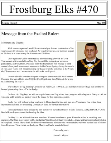
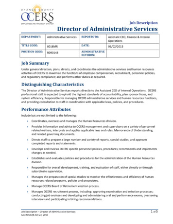
3Section 1 - IntroductionThe City of Alexandria envisions an integrated, multimodal transportation system that is accessible and safe forall users. For Alexandria to maintain its attractiveness as a place of residence and commercial destination,traffic impacts associated with new development must be minimized. City government recognizes that one’sability to move through and about the City affects both quality of life for residents and commercial growthpotential. Given this, all new development projects projected to generate at least 50 peak hour vehicle trips mustsubmit a multimodal transportation study for staff review. Multimodal transportation studies examine existingand future traffic, transit service, parking, and pedestrian and bicycle conditions. The depth of a required studyis based on the net number of vehicle trips a proposed development creates during its peak hour(s) of operation.City staff use multimodal transportation studies to optimize the mobility of pedestrians, transit users, bicyclistsand drivers. Study results help staff determine whether or not the City’s existing transportation infrastructureand services can support a proposed development. If a study suggests that a proposed development will impactmobility, staff uses the study to determine and justify the measures necessary to mitigate such impacts. Thismay include physical capital improvements or on-going programmatic measures per the City’s TransportationManagement Plan Special Use Permit process as defined by Section 11-700 of the Zoning Ordinance. Afterworking with an applicant to determine any necessary mitigations, staff makes subsequent recommendations tothe City’s Planning Commission and City Council.Per Section 11-709 of the Zoning Ordinance, the following Guidelines provide technical procedures to analyzeand report the effects of new development on transportation facilities in Alexandria. The Guidelines areintended to standardize the submittal requirements and evaluation systems employed to provide acomprehensive analysis of the impacts of a proposed development. Beyond typical DSUP applications, theGuidelines also detail the technical procedures used to analyze traffic impacts for Coordinated DevelopmentDistricts and Small Area Plans.Concept StagesReviewStageProcess Overview for Multimodal Transportation Studies Required of Standard DSUP ProjectsThe Guidelines apply to development projects subject to the site plan review process as defined in the ZoningOrdinance, Section 11‐400. For typical Development Special Use Permit projects (DSUPs), the review of suchprojects for transportation matters is conducted concurrently with the site plan review process.StepsStep 1: Prior to its first submission, an applicant may choose to contact the Department ofTransportation and Environmental Services’ Division of Transportation to discuss potentialrequirements for a transportation study. If desired, the applicant may coordinate with staff on thescreening worksheet during this call or meeting, or may choose to fill out this sheet separately.Step 2: All applicants must submit a Transportation Screening Worksheet with any Concept 1phase submission. Based on the information contained in the worksheet, T&ES staff will use thedevelopment thresholds as set forth in this document to determine if the applicant is required tosubmit a Transportation Management Plan Special Use Permit and/or a MultimodalTransportation Study, or if no further action is required.Step 3: If the applicant is required to submit a TMP or multimodal transportation study, theapplicant must submit a draft version of the scoping form to T&ES Traffic Engineering Divisionduring the Concept 2 phase of the site plan process. The form must document all proposedmethodology and elements to be used in the transportation study, such as data sources,
4Completeness & Preliminary Stagesassumptions, trip generation, trip distribution, and mode share, and must be submitted to theTraffic Engineering Division of T&ES for approval.Step 4: Upon submittal of the draft scoping form, the applicant schedules a scoping meeting withthe Traffic Engineering Division of T&ES.Step 5: The applicant and City staff review, confirm, and/or edit assumptions listed on the draftscoping form.Step 6: Based on coordination at the meeting, the applicant prepares a final scoping form forapproval by the T&ES Traffic Engineering Division. This agreement outlines the requiredcontents of the transportation study and agreed to assumptions. The agreement should be signedby the City and the applicant, and should be included in the appendix of the transportation study.The agreement should note any agreed timing associated with submission. Generally speaking,staff requires that the transportation study be submitted two weeks prior to the applicant’sverification of completeness submission. T&ES may require the study to be submitted earlier,depending on the project’s extent. Submission timing will be discussed and agreed upon at thescoping meeting based on the magnitude of the project.At the scoping meeting, staff will also provide the applicant with a tabular format for data inputfor existing traffic counts and any relevant parking studies. All survey data must be entered andprovided to staff electronically with the submission of the transportation study.Step 7: The applicant submits the following materials to the development case’s primary planner: (5) seven hardcopies of the study (2 for Planning and Zoning, 1 for TransportationPlanning, 1 for Transit, and 1 for Traffic Engineering) (1) one electronic copy of the study for upload A thumbdrive, CD, or other electronic media with existing traffic counts and parkingoccupancy information.Timing for the submission shall be aligned to the timing agreed upon at the applicant’sscoping meeting, as documented in the applicant’s scoping form. The transportation studywill be routed to the appropriate parties for review.Step 8: T&ES reviews the transportation study concurrently with the verification of completenesssubmission and requests any necessary revisions from the applicant prior to the preliminaryplan’s submission. While mitigations are not technically finalized until the preliminary plan’sapproval by the City’s public bodies, proposed mitigations—including non-vehicularimprovements—should be reflected in the transportation study.Step 9: After incorporating any requested revisions (if necessary) the applicant submits a revisedtransportation study to the case’s primary planner. The transportation study will be routed to theappropriate parties for review. If the electronic existing counts or parking occupancy countsrequired revision, these items will also need to be resubmitted.Step 10: Following a final review of the transportation study, T&ES will prepare conditions forinclusion in the staff report. Conditions are designed to address the transportation issues andconcerns noted in the transportation study.Step 11: Approving bodies review and take action on the development application. If a study wasconducted for a project site and there is updated information that would impact the transportationnetwork or modify the transportation study in any way, the applicant will be required to resubmitan updated transportation study before approval by Planning Commission and Council. Anupdate memo may be accepted by the City with prior approval by the Director of T&ES.Circumventing the threshold by submitting piecemeal development applications is not permitted. If theapplicant submits a new development application at an adjacent location within a five‐year period of the initial
5submission, T&ES will direct the applicant to perform a new transportation study that includes all tripsgenerated by all applications within the last five years.Multimodal Transportation StudiesWhile the technical requirements of these Guidelines generally apply to multimodal transportation studiesrequired of Coordinated Development Districts (CDD) and Small Area Plan (SAP) planning processes, there area few important differences.SAP and CDD plans typically lay the groundwork for subsequent DSUPs. SAP and CDD plans are typicallyperformed at a more conceptual level than DSUPs. Information regarding specific development siteprogramming, including details on site layout, access, and circulation, may not be available at the SAP andCDD stages, or may change between SAP/CDD approvals and DSUP reviews. Consequently, the agreementsestablished at the scoping meeting for SAP and CDD plans will likely differ from those established at scopingmeetings for DSUP projects.A CDD differs from a DSUP in that a CDD includes a number of parcels and properties—sometimes evenincluding properties not owned by an applicant. A CDD locks in certain elements such as land use, a streetframework, or the phasing of a development area. A CDD applicant must submit a multimodal transportationstudy through the typical application process detailed above. Unless otherwise determined by the Director ofTransportation and Environmental Services through a memorandum of understanding (as detailed below), aCDD’s transportation study shall not function as a substitute for subsequent transportation studies provided withDSUP applications for the following reasons: Various DSUPs within a CDD may not be ready for immediate development; site environment andbackground conditions may have substantially changed.Staff may need to assess intersections that were not originally included within the scope of the CDDstudy—particularly internal intersections.Mitigations and phasing assumptions that are developed through the SAP or CDD processes should bereassessed at the DSUP stage as finer detail becomes available regarding use, road network, garageentryways, etc.Property owners not involved with the initial multimodal transportation study process may benefit from theopportunity to select their own consultants and directly coordinate with staff.The SAP process is driven by City staff—often in coordination with property owners. SAP transportationstudies aim to support City planners’ understanding of appropriate densities within a given planning area.Multimodal transportation studies generated through the SAP process are typically more conceptual in natureand less detailed than those required at the DSUP stage. Unless otherwise determined by the Director ofTransportation and Environmental Services through a memorandum of understanding (as detailed below), amultimodal transportation study completed through the SAP process shall not fulfill the requirement of atransportation study at the CDD or DSUP levels.Memorandum of Understanding of Transportation Study RequirementsThe City anticipates that some property owners will request consent from the Director of Transportation andEnvironmental Services to eliminate the transportation study requirements at the DSUP application stage incases where studies have been recently completed in support of SAPs or CDD applications. In such cases,applicants should anticipate this request prior to the initiation of the associated CDD or SAP study. Applicantsshall draft a Memorandum of Understanding, to be signed by the applicant and the City, detailing theapplicant’s study requirements. Unless if a prior agreement has been established through an MOU, an applicantwill not be permitted to forgo associated DSUP multimodal transportation studies.
6The MOU shall, at minimum, address the following: justification of why the DSUP transportation study or studies are not needed the agreed on scope of the larger CDD or SAP study, to include:o all intersections/blocks to be studied1o all study assumptions timing for all SAP approvals or development applications relevant to the request agreement that, should staff deem improvements necessary at the DSUP stage that are not identified in theCDD/SAP study, these may be conditioned at the DSUP stage any phasing or timing requirements that would invalidate the MOUScoping MeetingThe purpose of the scoping meeting shall be to 1) determine the scope of the transportation study and/or otheraddendum studies (e.g. parking study) as needed, 2) determine the submission timing for the transportationstudy, and 3) allow the City and applicant to discuss requirements, methodology and any special considerationswhich may exist prior to the commencement of work. If a transportation study is required, the applicant and/ortheir transportation consultant shall submit a draft scoping form prior to the scoping meeting. TheTransportation Scoping Form (Appendix B. 2.) is the template for the scoping form and includes all subjectmatter to be addressed in the transportation study, including but not limited to: proposed usesmode shareinternal trip capturetrip distribution percentagespeak hour of operationsubmission timingMode share and internal trip capture percentages have the potential to greatly impact modeling scenarios.Additionally, mode share and internal trip capture are not static, but may change over time based on anticipatedpublic improvements or transportation trends. Any proposed mode shares and internal capture rates will bescrutinized by City during the scoping meeting. Applicants should be prepared to justify these assumptionsusing documentation and processes consistent with guidance from the Institute of Transportation Engineers(ITE) or the Transportation Research Board (TRB).Based on the discussion at the scoping meeting, the consultant will revise the draft scoping form for thetransportation study prior to beginning work. The agreement is to be signed by both parties before workcommences to document all of the assumptions to be included in the study. The City will provide comments tothe consultant through the existing development review process. Comments on studies submitted prior tocompleteness will be packaged for the applicant with the verification of completeness set of comments.Comments on revised studies will be provided to applicants packaged with comments on any preliminary plan.Future UpdatesThese Guidelines are not static. The City will review and revise the Guidelines as necessary. Future updatesmay re-examine the City’s requirements as best practices and industry standards progress. The City also intendsto revisit these Guidelines as warranted by changes to societal preferences or technological innovation in landIntersections and streets must be specifically identified in the agreement. Phrasing such as “internal intersections” will not beaccepted. In cases where the applicant proposes new streets, graphic identification may prove beneficial.1
7development, transit, shared-ride, and delivery service economies, and the automobile marketplace. Manyemerging trends, such as economic indicators, changing preferences, and the advent of autonomous vehicleswill have an evolutionary effect on travel and infrastructure needs. None of these trends have a certain enoughoutcome at this time to influence a change to the transportation impact analysis process; however, the Cityexpects to take a proactive approach to such trends as evidence materializes.
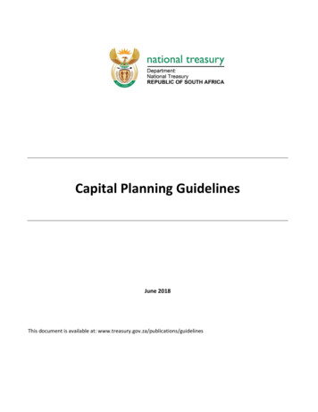
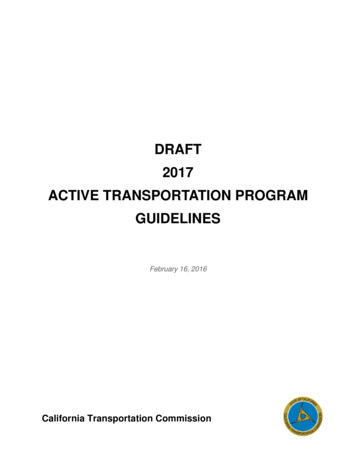
8Section 2 – Overview of Study Requirements & Appropriate ResourcesThis chapter provides technical guidelines to analyze and report the effects of new development on multimodaltransportation facilities in Alexandria. This chapter describes the standardized submittal process and reportingrequirements to provide a comprehensive analysis of impacts related to development proposals and proposedmitigation strategies.Study ThresholdsThe requirement to complete a multimodal transportation study is established through these Guidelines persection 11-709 and 11-704 of the Zoning Ordinance. The table shows the thresholds of the development sizecategories based on peak hour vehicle trips.Peak Hour Trips*Documentation RequiredDevelopment Size CategoryDSUP 50N/AN/ADSUP50‐99MultimodalTransportation StudySmallDSUP100‐249MultimodalTransportation StudyMediumDSUP 249all CDDs and SAPsMultimodalTransportation StudyLargePeak HourGenerally, staff expects that the applicant’s requirement to complete a study shall be based on conditionsassociated with the peak hour of the adjacent roadway in the AM or PM, whichever is greater; however, Citystaff retains the flexibility to account for variation based on use and transportation trends. Staff also retains theflexibility to direct the applicant to use a specific resource/land use code to assess trip generation for thepurposes of determining whether or not a threshold is met.For purposes of determining the study thresholds, the City uses unfactored vehicle trip generation rates asindicated on the Scoping Intake Form. The unfactored rates do not include discounts for pass‐by trips or sitespecific assumptions regarding mode splits, etc. Existing trips for currently occupied developments may becredited so that the study thresholds reflect net new vehicle trips to the site. Existing trips should be establishedthrough either the use of unfactored standard ITE rates or equations consultation with the City.
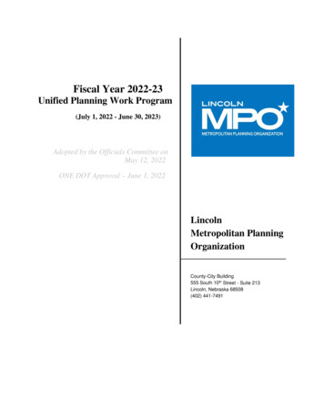
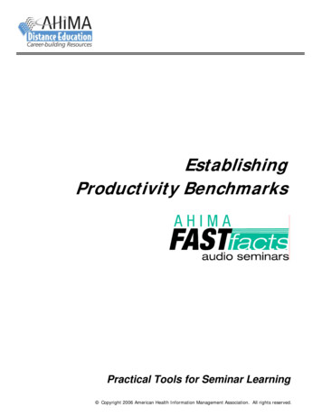
9Study AreasEach development size category has a corresponding study area relative to the size of the potential impact. Thetransportation study will cover each mode of transportation with different methods; therefore, some modes willhave a unique study area based on the characteristics of that mode. The study area will be finalized at thescoping meeting by the Director of T&ES. The study areas are defined in the table below.Study Area Guidelines by Development Size CategoryDistances shall be measured from the site perimeter—distances shall not be measured from a site centroid.SizeVehicular Study AreaSmallAt a minimum, include all sitedriveways and intersections within1000 feet radius OR one signalizedintersection in each direction,whichever is greater.Transit, Bicycle andPedestrian Study AreaParking Study AreaStreets adjacent to siteStreets curbs adjacent toand across from site,limited to the lesserdistance of 1 block or 300feet.Area within one‐quartermile walkshed of the siteTwo block radius OR1,000 feet radius,whichever is less.At a minimum, include all sitedriveways and intersections withinMedium one‐quarter mile radius OR threesignalized intersections in eachdirection, whichever is greater.At a minimum, include all siteLarge driveways, internal intersections,and intersections within a one‐halfDSUP mile radius OR four signalizedStudies intersections in each direction,whichever is greater.Include all major gateways into thesite and major intersections withina one-half mile radius OR fourLargesignalized intersections in eachdirection, whichever is greater.CDD andStudy intersections are to beSAPdetermined at the scoping meetingStudiesand may/may not include internalintersections, depending oncontext.
10Required Analyses and Horizon YearsAt minimum, the following analyses shall be required based on the required study size.DSUP applications without multiple phases:1. Small and medium developments - Applicant is required to perform a-d.a. Existing conditionsb. Opening year analysis without subject developmentc. Opening year analysis with subject developmentd. Opening year analysis with subject development and mitigation (if necessary)2. Large development – Applicant is required to perform a-g.a. Existing conditionsb. Opening year analysis without subject developmentc. Opening year analysis with subject developmentd. Opening year analysis with subject development and mitigation (if necessary)e. Opening year plus six years analysis without subject developmentf. Opening year plus six years analysis with subject developmentg. Opening year plus six years analysis with subject development and site mitigation (if necessary)DSUP applications with multiple phases:1. Small and medium developments: applicant is required to perform a-h.a. Existing conditionsb. Phase one opening year analysis without subject developmentc. Phase one opening year analysis with subject developmentd. Phase one opening year analysis with subject development and mitigation (if necessary)e. Phase two opening year analysis without subject developmentf. Phase two opening year analysis with subject developmentg. Phase two opening year analysis with subject development and mitigation (if necessary)h. Continue e‐g for each phase.2. Large developments: For large developments, six years after final phase is complete should not to exceed 25years from project initiation. If it does exceed 25 years, then 25 years from project initiation shall be reviewed.Flexibility for scenarios may be granted due to context. Additional scenarios may be required if more than twophases are proposed.a. Existing conditionsb. Phase one opening year analysis without subject developmentc. Phase one opening year analysis with subject developmentd. Phase one opening year analysis with subject development and mitigation (if necessary)e. Phase two opening year analysis without subject developmentf. Phase two opening year analysis with subject developmentg. Phase two opening year analysis with subject development and mitigation (if necessary)h. Phase two opening year plus six years analysis without subject developmenti. Phase two opening year plus six years analysis with subject developmentj. Phase two opening year plus six years analysis with subject development and mitigation (if necessary)The horizon year(s) should be related to the opening date of the proposed development or build‐out of majorphases of a multi‐year development or long‐range transportation plans or other significant transportationnetwork changes. Horizon years will be established during the scoping process.
11For SAP and CDD studies, the requirements of any established MOUs will supersede the above requirements,when applicable. For any studies impacting a state road, VDOT requirements are applicable, and studyrequirements may be adjusted as necessary.Mitigation and ConditionsThe City strives to maximize the utilization of prior investments in roadway capacity and supports a multimodalvision per its approved Transportation Master Plan. To this end, the City recognizes that improvementssupporting increased vehicular capacity sometimes come at the expense of the travel experiences of pedestrians,bicyclists, and transit users; therefore, decisions about right-of-way design and operations must balance theneeds for users of all modes. The City may examine potential mitigations to improve substandard mobilityconditions with consideration of the quality of service provided for all modes of travel. Requested mitigationswill help the City balance the needs of all users to provide safe and efficient travel.For conditions developed in association with CDD applications or SAP rezoning approvals, the applicant shouldnote that the City retains the right to condition subsequent DSUP applications based on additional informationmade available through any multimodal transportation studies developed during the DSUP review process.ResourcesAll methodology data sources used should be well documented in the transportation study. The latest edition ofeach of the sources listed below are typically acceptable, but require approval through coordination with staff.Sources not referenced in the Guidelines may be approved by the Director of T&ES or his designee and will bedetermined in the scoping process. The following resources may be used as sources:A.B.C.D.E.F.G.H.I.J.K.City Approved StudiesField ObservationsUrban Land Institute, Shared Parking Second Edition, 2005Institute of Transportation Engineers Trip Generation, 9th Edition, 2012Institute of Transportation Engineers Transportation Planning Handbook, 4th Edition, 2016Institute of Transportation Engineers Trip Generation Handbook, 3rd Edition 2014Washington Metropolitan Area Transit Authority 2005 Development Related Ridership SurveyAmerican Community Survey 5-year samples and Decennial SurveyMetropolitan Washington Council of Governments, Transportation Travel Demand Model, version 2.3Metropolitan Washington Council of Governments regional land use Cooperative ForecastsVirginia Department of Transportation (VDOT) Average Daily Traffic (ADT) volumes from dated no morethan two years prior to the current calendar year.L. Transit agency approved data from Washington Metropolitan Area Transit Authority (WMATA), DASH,Fairfax Connector, ART, PRTC, etc.Additional Reference MaterialThe City strongly encourages applicants to reference City approved materials detailed below. The followingplans contain additional guidelines and assumed improvements that the applicant may be asked toconsider/employ for multimodal transportation studies.A. Small Area Plans and Associated TransportationStudies and/or AppendicesB. 2016 Pedestrian and Bicycle Master PlanC. 2016 Complete Street Design GuidelinesD. Bicycle Parking StandardsE.F.G.H.Alexandria’s Capital Improvement PlanAlexandria’s Long Range PlanTransportation Master PlanVDOT Chapter 527 Guidelines, where relevant
Section 3 – Vehicular TransportationIntroductionThis section defines the elements that are required for the vehicular traffic impact analysis component of amultimodal transportation study. A thorough study shall address each of the items discussed in the followingsections.Study AreaThe documentation should provide a description of the proposed site improvements, existing zoning and use,and proposed zoning within the study area. Anticipated land uses in the general vicinity of the site should beidentified in order to understand other factors influencing the study area.The local base map should include, but not be limited to:A. The street system with names of all streets in the study areaB. Study intersections numerically markedC. Shading of the study areaD. Shading of the site with the boundary outlinedE. Map should be to scaleF. North arrowStudy intersections will be determined during the scoping process. Any existing site access is guaranteed to be astudy intersection.Where build-out roadway and intersection configurations are different in future conditions from existingconditions, they must be based on approved infrastructure projects as determined by the City and agreed upon atthe scoping meeting.Data CollectionThe traffic data in the transportation study should be less than one year old at publication provided that nomajor geometric changes or traffic control changes have been implemented. The applicant may request approvalto use older traffic data. In the cases when such is appropriate, approval may be granted by the Director ofT&ES or his appointee during the scoping process. Data collection should be conducted when schools are insession. Counts may not be taken on Federal holidays or the day before or after a Federal holiday.All study intersections within the study scope should have full turning movement counts for vehicles,pedestrians, and bicyclists. For typical uses, traffic counts should be conducted Tuesdays through Thursdays fora three‐hour morning peak period between 6:30 and 9:30am and a three‐hour evening peak period between4:00pm‐7:00pm and should be summarized by 15 minute periods to identify peak hour.Some uses such as churches, bars, and tourism establishments generate demand at atypical hours. The Cityretains the flexibility to shift peak hour requirements based on location and/or use. Additionally, the City retainsthe flexibility to require applicants to collect and provide data on and additional weekend peak period, aswarranted by the project’s use. Any additional peak requirement will be determined and agreed upon at thescoping meeting.Existing ConditionsExisting peak hour intersection and intersection LOS, queue lengths and delay should be determined for allintersection movements within the study area based on the procedures described in the most current edition ofthe Highway Capacity Manual. Analysis of existing conditions should use the existing traffic signal timing andphasing.
13Trip Generation, Internal Capture & ModeshareThe most recent version of the Institute of Transportation Engineers (ITE) Trip Generation Manual, 9th Editionor the COG regional model are to be used as the primary sources for trip generation rates, or other as approvedduring the scoping process. When using the ITE Trip Generation Manual, use of the formulas is preferred. TripGeneration rates may be used in instances where formulas are not available, or where the formula does notaccurately fit the development levels. Refer to ITE Trip Generation Manual guidance on the appropriateapplication of trip generation rates.Any reduction for pass‐by trips or internal capture will require approval by T&ES during the scoping process.Pass‐by trips and internal capture will require a demonstration of how the figures were derived. The burden ofjustification for an internal capture rate falls on the applicant. While ITE may be acceptable, staff encourages—and may require—the applicant to collect data from local sites of similar use to justify internal capture rates ifdeemed appropriate by the Director of T&ES or his/her designee. The final internal capture rate shall be agreedupon during the scoping meeting and shall be approved at the discretion of the Director of T&ES
The SAP process is driven by City staff—often in coordination with property owners. SAP transportation studies aim to support City planners' understanding of appropriate densities within a given planning area. Multimodal transportation studies generated through the SAP process are typically more conceptual in nature