Transcription
HUGH E. TAYLOR,LAS VEGAS MID-CENTURY ARCHITECTHugh E. Taylor Research and Paradise Palms Units 1 & 2 HistoricDistrict Inventory and SurveyPrepared by:Michelle LarimeNevada Preservation Foundation620 S. 11th St. Suite 110Las Vegas, NV 89101Prepared for:Nevada State Historic Preservation Office901 S. Stewart St. Suite 5004Carson City, NV 89701
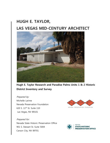
Cover Photo: 1634 Pawnee Drive in the Paradise Palms Survey Area. Photo by Michelle Larime,Nevada Preservation Foundation, 2015.NVSHPO Report # 21428The Paradise Palms Units 1 & 2 Historic Resource Survey that is the subject of this report hasbeen financed in whole or in part with federal funds from the National Park Service, U.S.Department of Interior, and administered by the Nevada State Historic Preservation Office. Thecontents and opinions, however, do not necessarily reflect the views or policies of the UnitedStates Department of the Interior or the Nevada State Historic Preservation Office. This programreceives federal financial assistance for identification and protection of historic properties. UnderTitle VI of the Civil Rights Act of 1964, Section 504 of the Rehabilitation Act of 1973, and AgeDiscrimination Act of 1975, as amended, the U.S. Department of the Interior prohibitsdiscrimination on the basis of race, color, national origin, disability or age in its federally assistedprograms. If you believe you have been discriminated against in any program, activity, or facilityas described above, or if you desire further information, please write to: Office of EqualOpportunity, National Park Service, 1849 C Street, NW, Washington, DC 20240.2
CONTENTSINTRODUCTION . 4METHODS . 6HISTORIC CONTEXTS. 13RESULTS & EVALUATION . 53REFERENCES . 673
INTRODUCTIONUntil recently, little has been known about the prolific Nevada architect Hugh E. Taylorand his contributions to Las Vegas. Early in 2014, Taylor donated his architecturalcollection to Nevada Preservation Foundation (NPF), and after an initial review of thecollection, it is clear that Taylor is one of Las Vegas' most significant mid-twentiethcentury architects. His architectural drawing collection consists of over 1,000 buildingprojects within the Las Vegas Valley and spans a time frame from the mid-1950s throughthe late Twentieth Century, well into the 1980s.Post World War II saw significant growth in population and development in the Las VegasValley. Defense-based industry and a growing interest in gaming and tourism broughtnew inhabitants to Las Vegas in the years just after the war, and the demand for newhousing was high. Modern architectural influences were seen throughout the AmericanWest region, including Los Angeles, Palm Springs and Las Vegas, and the Taylor Archivesprovide documentation of these principles. It was during this time that Hugh E. Taylorestablished himself in the City of Las Vegas. The majority of Taylor's projects wereresidential, both custom and track home designs. Taylor's Archives provide a substantialcollection of the type of modern architecture that influenced the building practices ofNevada's post-war boom in commercial and residential development.It was in this collection that NPF discovered construction documents for a portion ofsingle family residences located in Units 1 and 2 of Paradise Palms. To this point, Hugh E.Taylor has never been mentioned or documented as having been involved in thedevelopment of Paradise Palms in any capacity. The discovery of Taylor's drawings raisesnew questions concerning the housing tract's origins and the role Taylor may have playedin it. Subsequently, the State Historic Preservation Office (SHPO), in collaboration with theNevada Preservation Foundation (NPF), provided support in February 2015 to conductresearch into the history of the career of Nevada architect Hugh E. Taylor and his role inthe development of the Paradise Palms subdivision. In addition, the project included asurvey of the architectural resources constructed using the plans found in the Taylor4
Archives. The number and type of resources selected for recordation was determined bymutual agreement between the SHPO and the NPF. This report serves as a final summaryof the findings as a result of this survey and research. It will also serve as an aid forfurther research into the career of Hugh E. Taylor and the architecture and history ofParadise Palms.5
METHODSMichelle Larime served as the sole surveyor and author of the Architectural ResourceAssessment (ARA) forms, as well as the primary researcher and author of theaccompanying report. Larime has a Bachelor of Architecture, served as the interimexecutive director for Nevada Preservation Foundation (NPF), volunteers on NPF’scommunication and program committees, and is currently pursuing a Master’s in urbanplanning.Early in 2014, a local Las Vegas architect by the name of Hugh E. Taylor donated hisarchitectural collection to the Nevada Preservation Foundation. While the collection is stillearly in the process of being curated, an initial drawer survey of the architectural drawingsshows that Taylor's contributions to the built landscape of Las Vegas are quite substantial.Primarily known for his design of the now destroyed Desert Inn Hotel and Casino, thesheer volume of Taylor's collection reveals that he was one of the most prevalentarchitects within Las Vegas, especially during the mid-Century development boom thatfollowed World War II . The majority of Taylor's projects were custom-built and tractsingle family homes and are a reflection of the modern style of residential architecture.Taylor designed the bulk of his collection between 1955 through the late 1960'scoinciding with the peak of the Modern movement's popularity in American West regions,including Las Vegas, Los Angeles and Palm Springs. It was during NPF's initial drawersurvey that construction documents (CDs) were found for Units 1 and 2 of Paradise Palms,a mid-century residential tract development located within the central Las Vegas valley.According to the CDs drawn by Taylor, the homes built in Paradise Palms Units 1 and 2were designed and built in 1960 and 1961 and are modern, post-and-beam,Contemporary-style Ranch homes. The discovery of the construction documents offered aunique opportunity to compare the existing properties against their original Taylordesigns.The historic architectural survey of Paradise Palms Units 1 & 2 took place betweenSeptember 12, 2015, and September 17, 2015, with follow up visits during the months ofOctober 2015 and November 2015. The survey was completed using information takenfrom the Clark County Assessor's Office and website, and pedestrian observations noting6
architectural style, architectural details, and modifications made to each property. Thesurvey was completed for the purpose of evaluating the neighborhood for its eligibility forlisting in the National Register of Historic Places, using the ARA forms provided by theState Historic Preservation Office (SHPO). Digital photographs were taken of each propertyusing the surveyor's Olympus EM-10 and were captured in jpeg format. The field surveywas conducted in an orderly fashion, starting on the north end of the survey area onArapaho Circle and Seminole Circle, wrapping down to the south with Pawnee Drive,following on Aztec Way, Chikasaw Way and Cayuga Parkway, and finishing on OneidaWay. The ARA forms, however, are ordered in a different manner as they are grouped byelevation types which were drawn in the CDs of Paradise Palms by Taylor. Ten elevationcategories correspond to the elevation types drawn in the CDs.The primary focus of the research and historical survey was to evaluate whether or notUnits 1 and 2 of Paradise Palms were built according to Taylor's CDs. Up until the recentdonation of Taylor's archives, the original architecture of the residential tract developmenthas been attributed solely to the Californian architects Dan Palmer and William Krisel. Theobservations made during the pedestrian survey focused on comparing the existingproperties to the specified elevation types within Taylor's CDs to further identify if Hugh E.Taylor is in fact the original architect hired to design Paradise Palms. The CDs drawn byTaylor include a master plan which shows the siting and elevation type of each residencewithin Units 1 and 2 of Paradise Palms. Each residence was identified by a number andlettering system that identified the floor plan type, which direction the entrance faced, theelevation type, and the service yard wall material. The surveyor observed each residencefor evidence of these elements as identified by Taylor's site plan and elevations. In almostevery case, there was enough evidence to identify the residence as a match for Taylor'sdesign.In addition to evaluating the properties against the Taylor drawings, the surveyor madeinitial assessments of the historical integrity of each residence and their contributingstatus to a potential historic district. Integrity was evaluated using the seven aspects ofintegrity as defined by the National Historic Register of Places (NHRP): location, design,setting, materials, workmanship, feeling and association. In evaluating the properties7
against Taylor's drawings, design was the primary area of concern in determining thehistorical integrity of the property. Materials and workmanship were also key areas offocus in determining eligibility. In order to evaluate whether or not the residenceremained true to the original architecture, special attention was paid to the spatialrelationships, massing and architectural details of the street facing elevation of theproperty. Although Taylor provided ten different elevation styles as part of his CDs, eachresidence had the common features of a primary residence; enclosed, open air serviceyard, and adjacent carport, which defined the massing and spatial relationship of theresidence on its site. In order to qualify for individual eligibility, these spatial relationshipsmust remain intact. In addition, Taylor's elevations share common materials, roof lines,window placements and architectural details, all of which can be observed in Taylor's CDs.Individually eligible properties were recommended only when these qualities wereobserved to be preserved with very little to no modification.In evaluating the contributing status of eligible properties to a potential historic district,however, equal weight was given to all of the seven aspects of integrity and in manycases the feeling and association of the property contributed heavily toward itscontributing status. Many of the residences have had modifications made, which isexpected for properties that are now over fifty years in age. Contributing status wasdetermined by whether or not modifications to the property enhanced or compromisedthe original character of Taylor's design. The modifications range in scope from new roofsand carport conversions to new exterior siding materials. All of these types ofmodifications can have some effect on the original integrity of the residence. However, inmany cases the modifications that were made did not appear to have an adverse effecton the historic integrity of the property’s key features. In this way, feeling and associationwere just as important in evaluating the integrity of a contributing property. In general, ifthe original roof line and massing of the residence was left intact, a house that hadreceived a carport conversion into a garage or inhabitable space could be considered acontributor. In some cases, significant changes in roof lines and massing were acceptableas contributors because the workmanship and design were carried out according toModern principles as implemented by Taylor's design. Modifications to material was alsoconsidered acceptable insofar as the new material evoked the same general feeling of8
Taylor's design. Common replacement materials that were accepted in evaluating integritywere wood siding, stucco, stone veneer and brick and CMU type block.Throughout the year 2015, archival research was conducted as necessary to define thehistorical context of the surveyed area, as well as to collect additional evidence of Hugh E.Taylor's involvement (or lack of) in the design and construction of Units 1 & 2 of ParadisePalms. This research included visits to the Nevada State Museum where the Las VegasReview-Journal archives are housed, visits to the University of Nevada, Las Vegas LiedLibrary and Special Collections, and visits to the Clark County Building Department as wellas the Clark County Assessor's Office. In addition, the Hugh E. Taylor oral history anddrawing archives were consulted, made available through Nevada PreservationFoundation. Several websites were also consulted. Most notable the Clark CountyAssessor's site provided early owner as well as current owner information, the USGS sitefor current and historic map information and Earthpoint for calculating the UTM locationof the residences. Several interviews were also attempted with identified players of thedevelopment of Paradise Palms. However, most of the individuals were reluctant to meetwith the researcher, resulting in little information from these sources.A few discrepancies and limitations should also be noted as they no doubt affect theresults of the research and survey. Most notably, no building permits could be located toconfirm the actual date of construction. As a result, the researcher considered the dates ofconstruction recorded from the Clark County Assessor's website as generally correct andentered onto the ARA forms. Also, many of the interviewees who were contacted werenot only reluctant to meet with the researcher, but also denied Taylor having made anycontributions to the design of Units 1 and 2 of Paradise Palms, despite being presentedwith contradictory information. In most cases, only the street facing facade was visible,although a handful of properties were situated on a corner or sited in such a way thatone of the side elevations was also visible. No other elevation outside of these werevisible and therefore not included.A reconnaissance survey was preformed for all 75 properties located within Units 1 and 2of Paradise Palms. The survey showed that of the 75 properties, three had been converted9
to commercial zoning and 72 remained single-family. Initial observations included whetheror not the property matched the elevation type listed in Taylor's construction documents,any noticeable alterations, the overall condition of the property and an eligibilityrecommendation towards a NRHP Historic District. Overall, 36 properties were found to beeither individually eligible for listing in the National Register, or as a contributing resourcetowards a NRHP Historic District. A district form was completed detailing the findings ofthis reconnaissance survey and recommends Units 1 and 2 of Paradise Palms as eligiblefor listing in the NRHP as an historic district. The district boundaries, however, have beenmodified to exclude properties on the fringe that have lost a significant amount ofintegrity. After removing these properties from the district, it was found that 35 propertiesout of 61 total properties were contributing. This brought the integrity percentage ofcontributing properties in the neighborhood up to 57 percent.Due to limited time and resources of the surveyor, separate ARA building forms werecompleted only for the 36 properties that were found to be either individually eligible forlisting with NRHP or as a contributing resource towards a NRHP Historic District. The 36properties were chosen because these served as the best example of Taylor's design andfeature the modernist architectural design principles which coincide with the subject ofthis study. These properties also showcase the likelihood that Taylor is in fact the originalarchitect and designer of Paradise Palms. A large majority of the remaining propertiesshowed evidence of Taylor's design as well, but did not present the level of integrity thatthe chosen properties include.10
Figure 2.1 Paradise Palms subdivision boundaries and survey area.11
Figure 2.2 Google Earth image showing satellite imagery of housing and siting.12
HISTORIC CONTEXTSThe Paradise Palms residential subdivision consists of approximately 1800 single-familyhomes, located on 720 acres of land within Paradise Valley under the jurisdiction of ClarkCounty. The subdivision consists of 15 units, the majority of which were developed duringthe 1960s and are representative of the post-war housing boom in the City of Las Vegas,Clark County and the development of the suburbs that formed the metropolitan area ofLas Vegas today. The focus here is primarily on Units 1 and 2 of Paradise Palms, whichserved as the original residential development for the large-scale master plan that makesup the entirety of Paradise Palms. The architecture of the original units is in many waysunique from its neighboring units, although the entire subdivision is a prime example ofthe mid-century Contemporary Ranch type of domestic architecture. Ranch type housingwas introduced just before World War II, incorporating elements of the Contemporarystyle that was popular in Southern California after the war. This style is attributed tomodern, California-based architects such as J.R. Davidson, Richard Neutra, Charles Eames,and Eero Saarinen, among many others, whose ideas were spread throughout America viathe case study houses published by Arts & Architecture between 1945 and 1965. Alsopopular in Palm Springs, the Contemporary Ranch hybrid style was ideal for hot, ariddesert climates and is also known as Desert Modernism among mid-century enthusiasts inthe American West. Mid-century architects, like Nevada architect Hugh E. Taylor,incorporated this style into their own work, inevitably shaping both residential andcommercial development during much of the post-war construction boom during the1950s and 1960s of Las Vegas History.Historic Townsite Development of Las VegasLas Vegas has long been heralded as the oasis in the desert. Prior to the nineteenthcentury, the natural valley primarily served as a rest stop for early explorers, missionariesand travelers alike. The fertile meadows and natural springs of the valley attracted manyindigenous people, the most well known being the Paiute, a Native American tribe withroots in Nevada, Utah, Arizona and parts of California (Moehring and Green 2005). The13
first non-native people to happen upon Las Vegas were Spanish missionaries who lookedto forge a route between New Mexico and California, making their way through Utah andwhat are now parts of Nevada. This early exploration established portions of what is nowknown as the Old Spanish Trail. In 1826, American fur trapper Jedediah Smith altered theSpanish path and blazed new trails through northern Arizona and southwestern Utah,through what would eventually become the Nevadan gateway to southern California(Moehring 1989). A few years later in 1829, Antonio Armijo and his party followed thenew trail laid by Smith and the pursuit of water eventually led them into the Las VegasValley (Paher 1971). Known as the Muddy Las Vegas Amargosa River route, the trail wasnot heavily traveled until after explorer John C. Fremont documented his 1844 tripthrough Las Vegas in a best-selling report (Scumacher 2015). Fremont was the first torecord Las Vegas on an American map, naming it "The Meadows" in Spanish (Scumacher2015).By 1854, Congress established a monthly mail run from Salt Lake City to San Diego,passing through Las Vegas and San Bernardino, which allocated federal funds towardswidening and grading the trail for travelers including troops, horses and freight wagons(Moehring 1989). The first Euro-American settlers who arrived in Las Vegas were a groupof Mormon missionaries sent in 1855 by Brigham Young. Having settled south in SanBernardino a few years earlier, the settlement was part of Young's plan to extend theMormon religion into the southwest region. The group established a small fort andmission and offered a safe haven for traders and mail riders while serving the church'smission to convert native people to the Mormon religion (Schumacher 2015). The fort wasquickly abandoned, however, due to difficulties with agricultural and the native people.Octavius Decatur Gass acquired what remained of the fort in 1865, where he operated asuccessful cattle ranch for several years (Moehring 1989). The ranch, named "Los VegasRancho”, reestablished Las Vegas along the popular trail. Gass, however, was eventuallyforced to leave the ranch after defaulting on loans and it was acquired by Archibald andHelen Stewart in 1882. Archibald died soon after the acquisition, but Helen continued tooperate the ranch with her children for almost two decades. After learning of plans for arailroad, Helen sold the majority of the ranch to Montana Senator William Clark, retainingownership of 160 acres where she lived as one of the first settlers of the Las Vegas oftoday. Helen was an early member of the women's organization the Mesquite Club, and14
eventually earned the title of the "First Lady of Las Vegas" for her role as a prominentfigure in Nevada's history (Moehring and Green 2005).William Clark purchased the Stewart ranch with the sole intention of establishing arailroad line connecting Salt Lake City, Utah to Los Angeles, California. Clark was anentrepreneur who not only had the funds to start a railroad, he recognized the growingmarket of Southern California and realized that Las Vegas was the ideal stopping pointbetween the two cities. In addition, the previous trade and mail route between the twocities made the existing trail via the Las Vegas Valley the most cost-efficient route. Lastly,Clark knew that Las Vegas provided enough water to not only sustain a town, but toservice the locomotive industry as well (Moehring 1989). Clark formed the San Pedro, LosAngeles, and Salt Lake Railroad in 1900 and began construction in Las Vegas as early as1904. Workers constructed a tent camp on the west side of the tracks which served as thefirst twentieth century settlement within Las Vegas.Before selling her land, Helen Stewart had her ranch surveyed by John T. McWilliams whoacquired 80 acres west of the planned railroad by the government, which included thearea of the railroad construction camp site. After surveying the land, McWilliamsestablished the townsite of Las Vegas in 1904 and began the sale of his speculative lots(Rayle and Ruter 2013). At about the same time, the Las Vegas Land and Water Company,a subsidiary of the railroad, surveyed its own land on the east side of the tracks andrecorded the area as "Clark's Las Vegas Townsite" in 1905. Clark's townsite was aligned tothe northeast-southwest line set by the railroad line which was shifted 27 degrees offnorth to allow for the straightest run of track through the flat valley (Hess 1993). Incontrast, McWilliam's townsite was aligned to the typical north-south line and consisted ofabout 150 buildings including saloons, businesses, boarding houses and homes.Meanwhile, Clark had his land staked into lots which consisted of 80-foot wide streetsbounded by Fifth Street and Main Street (east and west respectively) and Stewart Avenueand Garces Avenue (north and south respectively) (Rayle and Ruter 2013). Afteroverwhelming interest in Clark's land, he held a public land auction while McWilliam'stownsite dwindled, losing favor due to Clark's townsite's proximity to the railroad.15
At this point, Clark's townsite was located in southern Lincoln County, but due to thegrowth and development of the railroad town, Nevada’s Legislature passed a bill in 1909to create Clark County, with Las Vegas chosen as the county seat. Las Vegas continued togrow and incorporated into the City of Las Vegas in 1911. Fremont and Main Streetsserved as the town's main commercial arteries while the majority of Main Street, whichran parallel to the rail tracks, consisted of businesses dedicated to the railroad. FremontStreet was the primary town center, and the remaining blocks were Las Vegas’ first,exclusive residential area. Development within Clark's townsite continued to flourish until1921, when Clark sold his interest in the San Pedro, Los Angeles, Salt Lake City Railroad tothe Union Pacific Railroad Company. Strikes by the union employees of the railroadeventually led to many of the services being relocated to Caliente, which stagnated thepreviously flourishing economy (Moehring and Green 2005). Simultaneously, the Las VegasLand and Water Company refused to make upgrades to the infrastructure of the city,which further hindered additional growth in the 1920's.In an effort to combat the recession, Las Vegans turned to Tuscon and Palm Springs forinspiration and began to look for ways they could turn the year round sunshine intoeconomic opportunity. A two hour drive from Los Angeles, Palm Springs begandeveloping into a resort city in the mid-1920s, which caught the eye of many of Vegas'sentrepreneurs (Hess 1993). Investors looked toward building varying tourist destinations,including a dude ranch for vacationers and prospective divorcees as well as a high classresort. Local workers had dug twin lakes for boat sports and swimming and had alsobegun to work on a dance hall and tavern. In 1927, Las Vegas began development on itsfirst golf course where the Westgate (formerly the Las Vegas Hilton) stands today(Moehring 1989). While these efforts were unsuccessful, they marked the city's desire toexpand their economy beyond a railroad town.It wasn't until the "Reclamation Era" and the Boulder Canyon Progress Act that waspassed in 1928 that the Las Vegas economy began to recover and experience anotherboom in growth and development. The Act funded the construction of a dam to regulatewater from the Colorado River to Southern California. The site chosen for the dam wasapproximately 50 miles southeast of Las Vegas, and while the site was too far for dailycommuter work, Las Vegas served as the shipping point for materials and supplies. Work16
on the massive construction project began in 1931 and an estimated 19 million wasinvested into the local Las Vegas economy as a result (Moehring 1989). In addition,Roosevelt's New Deal pledged even more millions into upgrading the city of Las Vegaswith new streets, sewers, and other infrastructure improvements.Tourism finally began to take hold of the local economy as people came from all over theAmerican West to see the construction of what was one of the largest engineering featsof the time. Concurrently, the Nevada legislature legalized gambling in 1931, leading tothe development of casinos along Fremont Street. And as other American West citiescracked down on illegal gambling, gamblers fled to Vegas on their weekends to avoid thelaw of their home states. In addition, the divorce laws were also relaxed, shorteningresidency requirements from three months to only six weeks, further enhancing thegrowing tourism economy. The divorce of movie star Clark Gable brought nationalattention to the relaxed divorce laws and people came from all over wanting to bedivorced "at the same place where Ria and Clark got theirs" (Moehring 1989: 30).The onset of World War II (WWII) brought even more federal money to Las Vegas asdefense development made its way to Las Vegas. Basic Magnesium, Inc. opened a factoryto the southeast of Las Vegas in what is Henderson today. The factory opened in 1941and quickly became one of the largest manufacturers of metallic magnesium, a keycomponent in weaponry manufacturing. The magnesium plant alone was responsible forgrowing Las Vegas' population by 15,000 people (Rayle and Ruter 2013). In addition, thefederal government allocated more than 3.5 million acres for military land and establishedthe U.S. Army gunnery range to the north west of Las Vegas. The Las Vegas Bombing andGunnery Range, as it was called, opened in 1941 and shuffled upwards of 4,000 studentsevery six weeks through the program during the height of WWII (Moehring 1989). Afterthe war, the Basic Magnesium Plant and the gunnery range closed, however state officialsworked with the federal government to establish a permanent military base on the site.Nellis Air Force Base was opened in 1950 as a result, which led to the "Atomic Age" of LasVegas, as a portion of the base was dedicated to the testing of nuclear bombs (Moehringand Green 2005). Further adding to the growing tourism aspect of Las Vegas, the citytook advantage of nuclear testing on the base, inviting tourists to stay and watch theblasts. All night parties with drink specials and other attractions exploited the test site17
blasts and "Atomic" became the word of the day for Las Vegas businesses in the early1950s. These early efforts towards tourism, coupled with the desire to rival Palm Springsas a resort destination, fueled the majority of mid-century growth as Las Vegas developedinto the tourism mecca it is today.Commercial Development in Las VegasAs previously mentioned, early commercial development was primarily centered aroundthe railroad where Fremont Street housed the majority of local businesses, and grew asthe town center for most of the early part of the twentieth century. Early roadimprovements in the 1920s focused on ro
HUGH E. TAYLOR, LAS VEGAS MID-CENTURY ARCHITECT . Hugh E. Taylor Research and Paradise Palms Units 1 & 2 Historic District Inventory and Survey . Prepared by: Michelle Larime Nevada Preservation Foundation. 620 S. 11th St. Suite 110 . Las Vegas, NV 89101 . Prepared for: Nevada State Historic Preservation Office . 901 S. Stewart St. Suite 5004