Transcription
ISSN 2277-2685IJESR/June 2016/ Vol-6/Issue-6/131-135Mrinal Singh et. al., / International Journal of Engineering & Science ResearchSOIL CHARACTERIZATION OF JABALPUR CITY USING BORE LOGSMrinal Singh*1, Rakesh Grover2, Dr.Shailza Verma31M.E. Scholar, J.E.C. Jabalpur, India.2Associate Prof., Dept. of Civil Engineering, Jabalpur Engineering College, Jabalpur, India.3Assistant Prof. Dept. of Civil Engineering, Jabalpur Engineering College, Jabalpur, IndiaABSTRACTGeotechnical engineering deals with the safe transmittal of loads due to various engineering applications to, andinto, the soil or rock mass. The soil and rock mass formations are heterogeneous and generally are subjected tostresses (due to various engineering applications) which are additional to those presently existing in the earthmass from its self weight and geological history. Due to these earth mass properties, the amalgamation ofexperience, study of what others have done in somewhat similar situations and site specific geotechnicalinformation are required to produce an economical, practical and safe substructure design. The correctinterpretation of the results obtained from field exploration and laboratory tests is one of the most importantcrucial parts of geotechnical engineering. Geotechnical data of Jabalpur city, collected by JEC civil departmentfor many years is in the raw format and numbers of tests are performed by us at different locations. To use allthis data for future and in further construction works, this data should be organised in a suitable database.Therefore bore logs are established to convert data from the raw format and to facilitate the interchanging dataamong organizations. Bore log will manipulate and query effectively necessary information from geotechnicaldata.Keywords: Investigation, Bore logs, Geological Profile, Incumbent.INTRODUCTIONSoil characterization provides the basic soil index property and engineering properties, which are determinedbased on in-depth exploration to identify and evaluate a potential hazard. Soil characterization involvesinvestigation1 (laboratory and field), data collection, interpretation of data and finally representing in terms ofbore logs2. Geotechnical soil characterization is usually done using experimental investigations of sieveanalysis, liquid limit, plastic limit, water content, standard penetration test, cone penetration test, etc.Soil characterization is carried out with the following objective:(a) Measuring and the interpretation of soil properties(b) To evaluate the parameters of soil(c) To assess the engineering parameters and to estimate the safe bearing capacity of soilA general soil characterization should describe:(a) The soil(b) Soil description and locationThis data can thus be used to select a site, design the foundation and earthworks.Need for Soil Characterization:(a) There are uncertainties in the ground, as a result of natural and manmade processes, that may jeopardize aproject and its environment if they are not adequately understood and mitigated.(b) An appropriate soil characterization will maximize economy by reducing, to an acceptable level, theuncertainties and risk that site conditions pose to a project.*Corresponding Authorwww.ijesr.org131
Mrinal Singh et. al., / International Journal of Engineering & Science Research(c) Soil characterization involves the determination of the nature and behaviour of all aspects of a soil and itsenvironment that could significantly influence, or be influenced by, a project.(d) The basic purpose of soil characterization is to provide sufficient, reliable information of the soil conditionsto permit good decisions to be made during assessment, design and construction phases of a project.(e) Soil Characterization should include an evaluation of subsurface features, sub surface material types,subsurface material properties.OVERVIEWGeotechnical engineering analysis and evaluation is valid only if the measured values are representative of insitu conditions. Properties of some materials are best measured in the laboratory, while others in field tests.Geotechnical investigation involves the following tasks (a) Need to define the bedrock depth, which is very important as purpose of the geotechnical investigations is toassess the influence of local site conditions on the bedrock.(b) Define groundwater table conditions considering seasonal variations(c) Perform in situ testing and procure samples for laboratory testing. Various geotechnical tests including bothin situ and laboratory tests are available for characterization.METHODOLOGYJabalpur city is situated in the heart of M.P. It stands majestically on the tropic of cancer and on the banks of theriver Narmada which flows through the white marble rock cluster site known for its beauty in the world. Thecity is located between 23º10' North latitude and 79º59' East longitude. Jabalpur city is spread over a total areaof 367 sq. km average elevation of 411 meters (1,348 feet) above the sea level. Numbers of tests wereperformed by geotechnical department of JEC Jabalpur at different locations of city and many tests wereperformed by us at many locations. Data obtained from tests were in raw format to use it for future reference itshould be preserved , this can be possible if we make bore logs of different locations using soil reports availablein geotechnical lab and soil reports made by us. Bore logs obtained will describe soil profile of a definite areawhich can be used by different organizations for fulfilling their project requirements.Soil report obtained at the time of testing using all these procedures- Boreholes were terminated as per thedirection. After positioning the rig at the specified location, for drilling through soil. Borehole was sunk bymechanically operated Cable Tool (Shell & Auger) in soil and rotary drilling in rock. Flush jointed steel casingtubes were provided to prevent possibility of side collapse in boreholes. After reaching the desired depth,depending upon the soil layer encountered, either Standard Penetration Tests & Vane Shear Tests wereconducted or Undisturbed or disturbed soil samples were collected. The location of the boreholes is shown inthe enclosed sketch. The field tests and sample collections were conducted in the boreholes in accordance withthe relevant Indian Standard codes of practice and as per the following.(a) Standard Penetration Test in soils at regular depth intervals(b) Disturbed & Undisturbed soil samplesFIELD INVESTIGATIONS(a) Standard Penetration Tests - Standard penetration tests (SPT) were carried out in soil within boreholes todetermine strength characteristics of soil. This was carried out in accordance with IS: 2131. The number ofblows required to drive the standard split spoon sampler for penetration of 0.30 m by a 63.5 kg hammer fallingfreely from a height of 750 mm is recorded “N” Value at regular intervals in the borehole. If the sampler is notfully penetrating into soil, then the test was terminated after refusal noting the rate of penetration.(b) Sampling - Disturbed & Undisturbed representative soil samples were collected during investigations andsubsequently sent to laboratory for visual examination and testing. The disturbed soil samples were alsocollected from split spoon sampler.Copyright 2016 Published by IJESR. All rights reserved132
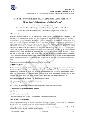
Mrinal Singh et. al., / International Journal of Engineering & Science ResearchLABORATORY INVESTIGATIONSAll collected soil samples from the boreholes were brought to laboratory for necessary testing and recheckingthe preliminary bore logs. The laboratory tests comprised of:(a) Grain Size distribution of all samples collected from boreholes- Grain size distribution was determined intwo stages. The soil fraction retained on 75 micron IS Sieve was analysed by Sieve analysis using standard setof IS Sieve as prescribed by IS 460 – 1962. Sieve analysis is again done in two stages. The oven dried samplesof soil was separated into two fractions by passing it through 4.75mm IS Sieve. The portion passing through thesieve was analysed by fine analysis using the IS Sieve Nos. 2mm, 1mm, 500, 425, 300, 212, 150 and 75microns. The portion retained on this sieve was analysed by coarse analysis using IS Sieve Nos. 100, 60, 20, 10and 4.75mm.(b) Atterberg Limits on all clay fractions- Liquid limit of the soil was determined by Casagrande method usingCasagrande type mechanical liquid limit apparatus. Plastic limit was determined as per the standard procedureIS: 2720(Part 5) -1985.(c) Natural moisture content- Natural moisture content of the soil was determined by oven drying method as perIS: 2720 Part – II, 1969. Weights were taken to an accuracy of 0.001gr.IS 1498 (1970) mentioned symbols and their usual meanings and details with hatching pattern and color code.Soil classification using group symbols is as follows:Group SymbolCoarse soilsGWGPGMGCClassificationSWSPSMSCFine soilsMLMIMHCLCICHOLOIOHPtWell-graded SANDPoorly-graded SANDSilty SANDClayey SANDWell-graded GRAVELPoorly-graded GRAVELSilty GRAVELClayey GRAVELSILT of low plasticitySILT of intermediate plasticitySILT of high plasticityCLAY of low plasticityCLAY of intermediate plasticityCLAY of high plasticityOrganic soil of low plasticityOrganic soil of intermediate plasticityOrganic soil of high plasticityPeatRESULT AN DISCUSSIONGeneralised Geological ProfileA generalised geological profile [3] is prepared for individual boreholes of different locations of Jabalpur. Thedescription of the various layers is based on the laboratory test results based on IS classification. For the purposeof clarity, existing ground level is considered as 0.0m, datum for boreholes in the individual geological profile.Figure showing bore logs of some of the location:-Copyright 2016 Published by IJESR. All rights reserved133
Mrinal Singh et. al., / International Journal of Engineering & Science ResearchNSCB MEDICAL COLLEGEB1B2P3P40 Depth12345SPSCSMDRP LINEB1B2 Depth0246CICLRICHHAI INDUSTRIAL AREAB1B2B3B40 Depth2468CICHCOD DepthB1B2024SPIn above figures,B1, B2, B3, B4- BORE LOGS SHOWING SOIL CHARACTERISTICSDepth – meterCopyright 2016 Published by IJESR. All rights reserved134
Mrinal Singh et. al., / International Journal of Engineering & Science ResearchCONCLUSIONThis paper may prove helpful for the research scholars and designers with the availability of soilcharacterization by using bore logs of different locations with the sufficient information at same time they canchoose any of these data depending upon their quality control strategy. It must be remembered that geotechnicalengineering is a highly specialised area of civil engineering and it is incumbent [4] upon geotechnical agenciesto take all care to use the data available in bore logs format with minimum ambiguities.REFERENCES[1] Anbazhaganp STG, Divya C. Site response analyses based on site specific soil properties usinggeotechnical and geophysical tests: correlations between GMAX and N60, 4th international conference onearthquake geotechnical engineering paper no. 1286, June 25-28, 2007.[2] Asaoka A, Nakano M, Noda T. Soil-water coupled behavior of heavily over-consolidated clay near/atcritical state. Soils and Foundations 1997; 37(1): 13-28.[3] Banik S. Determination Of Bearing Capacity Of Shallow Foundation On Dhaka Sub-Soil Using SubLoading Tij Model. M Engg. Thesis, Department OfCivil Engineering, Bangladesh University Of EngineeringAnd Technology, Bangladesh, July 2014.[4] Gupta S. Interpretation of geotechnical report, Indian geotechnical conference, December 2010; 16-18.[5] Gupta GP, Tembhare BR, Mishra SR. Characterization and Classification of Soils o f GraniticTerrain In Jabalpur District of Madhya Pradesh. Agropedology 1999;9(2):77-81.[6] IS 1892 – 1979. Code of Practice for Site Investigation for Foundations, BIS, New Delhi.[7] Khouri NQ. Dynamic Properties of Soils, Master Thesis, Department Of Civil Engineering, SyracuseUniversity, 1984.[8] Luna R, Jadi H. Determination of dynamic soil properties using geophysical methods. Proc. of the FirstInternational Conference on the Application of Geophysical and NDT Methodologies to TransportationFacilities and Infrastructure, St. Louis, MO, December 2000.[9] Lambe TW, Whitman RV. Soil Mechanics, John Wiley and Sons, New York, 1969.[10] Nakai T. Modeling of soil behavior based on tij concept. The 13th Asian Regional Conference on SoilMechanics and Geotechnical Engineering, Kolkata, India, December 10, 2007.[11] Rashid MA. Seismic Microzonation of Dhaka City Based on Site Amplification and Liquefaction, M Engg.Thesis, Department of Civil Engineering, Bangladesh University of Engineering and Technology, Dhaka,Bangladesh, 2007.[12] Son le M. Compiling Geotechnical Data To Determine The Distribution And Properties Of Top SandDeposits In Quadrant K & L Of The Dutch Sector – North Sea, February 2002.[13] Terzaghi K. Theoretical Soil Mechanics, John Wiley And Sons, New York, 1943.[14] Terzaghi K, Peck RB. Soil Mechanics InEngineering Practice, (First And Second Edition), John Wiley AndSons, 1948 & 1967.Copyright 2016 Published by IJESR. All rights reserved135
Geotechnical soil characterization is usually done using experimental investigations of sieve analysis, liquid limit, plastic limit, water content, standard penetration test, cone penetration test, etc. Soil characterization is carried out with the following objective: (a) Measuring and the interpretation of soil properties