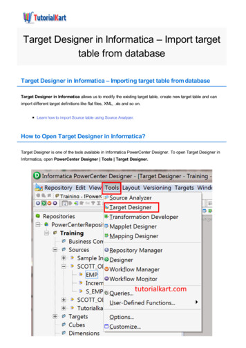
Transcription
PRODUCTCATALOGAVAILABLE ON SOCIAL MEDIAAUTHORIZED DISTRIBUTION PARTNERHi-Target Surveying Instrument Co. LtdADD: Building 13, Tian'An Technology Zone HQ Center, No. 555, North of Panyu RD, Panyu District,511400 Guangzhou, China.www.hi-target.com.cn 86-20-28688296 info@hi-target.com.cn 2021 Hi-Target Surveying Instrument Co., Ltd. All rights reserved.21A108
Established since 1999, Hi-Target is the firstprofessional high-precision surveying and mappinginstrument brand to be successfully listed in China.Hi-Target produces a wide range of surveyingequipment including GNSS receivers, CORSstations, TS, 3D Laser Scanners, GIS Data Collectors, UAV/UAS, and Hydrographic products toprovide complete commercial solutions for variousindustries.Survey and EngineeringHigh-precision GNSS RTK, Total Station and Optical ProductsLand survey is one of the indispensable technical means in topographic survey, land monitoring andconstruction engineering. In order to provide more reliable and effective solutions, Hi-Target focuses on theAs the leading brand in the geospatial industry,Hi-Target invests heavily in research and development, on top of collaborating with more than 100universities globally to bring the latest positioningtechnology and innovation for product development.innovations in GNSS RTK, total station and optical level technologies continuously. Advanced engines,high-precision algorithms and specific surveying technologies are the guarantees for users in the field work.Even in harsh environments, operators can obtain satisfactory measurement results with Hi-Target products.Integrated land survey solutions will greatly improve the quality of surveyors' daily work.Hi-Target will continue to develop products andtechnologies to meet the ever-increasing demandsof the Geospatial arena and you can count on us tobe the best in our field with professional solutionsand superior services.0102
iRTK5V200GNSS RTK SystemV200 GNSS RTK Receiver brings superior performance and high efficiency to support your fieldworkwith reliable solutions. Its deployment of the advanced RTK engine and new-generation IMU guarantees a 25% performance improvement even in the most demanding environments. Thus you can counton Hi-Target V200 for better productivity.New-Generation RTK SystemBenefiting from the next-generation GNSS engine, unlimited communication technology and innovative design,iRTK5, the high-quality scalable GNSS receiver, provides industry-leading GNSS RTK surveying solutions.KEY FEATURESNext-Generation GNSS EngineKEY FEATURESWith the full-wave GNSS antenna and the next-generation GNSS engine, it supports full constellation by336 tracking channels, enhanced initialization speed and anti-noise performance.ProPoint (optional)Brand-New ProPoint GNSS engine allows you to expand the boundaries of GNSS performance, with atleast 30 per cent improved performance in chanllenging GNSS environments.Advanced RTKFull-ConstellationEngineTrackingHi-RTP The Hi-Target Hi-RTP global correction service extends the correction source, enabling users to workin rural or remote areas in the world without a base station, getting rid of range restrictions. It can harnessall constellation signals from BDS, GLONASS, GPS, GALILEO with global distribution of 220 stations,providing centimeter-level positioning accuracy.Web UI220 Connected to 3rd-party L-Band corrections services, the iRTK5 GNSS receiver provides accurate,sub-decimeter positioning in all regions where RTK Network, GSM coverage or traditional GNSS basestation are not available.NFCBuilt-in RadioNFCEquipped with an ultra-light EPP material instrument caseof a high anti-strong impact, shock and impact resistanceand a centering rod that can be contracted to 1.25 m,making it durable and portable in the fieldwork.Greater FlexibilityIt can bring accurate and reliable results and boost efficientfieldwork with self-developed built-in IMU and core algorithm.Higher Accuracy and PrecisionEquipped with the High-Performance Patch Antenna,enhances the low elevation angle tracking capabilities andkeeps it maintaining a high gain for higher elevationsatellites while tracking low-elevation satellites.More StabilityHi-Target Hi-Fix enables continuous connectivity andquality results even if you lose the signal while using theRTK base station or VRS network under extremecircumstances.03Revolutionary Tilt Survey with Built-in IMUCompatibility withthird-party softwareMore PortabilityRTX (optional)IMUYou can benefit from the calibration-free tilt compensation technology, which means that once reachingthe surveying points, you can immediately start the operation without centring and the error is less than2 cm within 30 inclination. The function also provides resistance to the interference of magneticdisturbances, ensuring the high accuracy of data. Compared with bubble leveling, it has boostedworking efficiency by 20%.Hi-Fix TechnologyIt can reduce downtime in the field with continuousRTK coverage during correction outages from anRTK base station or VRS network.360 Omni-directional Antenna andMulti-protocol RadioThe top-mounted radio antenna extends the radioworking range and enables full omni-directionalcommunication, making the distance of datatransmitting and receiving extend to 20% longer.Multi-protocol radio, support Hi-Target,TRIMTALK450S, TRIMMARK III, TRANSEOT,SATEL-3AS, etc.Web UI ManagementA built-in Web management system forreal-time controlling and free configuration ofthe receiver. Users can check the status andinformation, make basic settings, upgradefirmware and download data, etc.HD Touch OLED ScreenThe 1.3-inch newly-designed color touchscreen with 240*240 resolution allows usersto quickly check and set the receiver statusfor easier fieldwork.04
iRTK4V30 PlusA Simple but not Simplistic GNSS SystemiRTK4 is a full-featured, intelligent GNSS receiver system equipped with an integrated new-generation full-frequencyantenna and advanced multi-channel engine, allowing users to attain accurate, reliable solutions. Users can also takeadvantage of calibration-free tilt compensation technology without leveling the survey pole to collect point data in moreplaces. In addition, the Smart Base function in iRTK4 automatically pairs the Rover with the Base by using Hi-Targetglobal servers and ensuring communication by providing the best connection.The iRTK4 system can maximize your productivity in unprecedentedly challenging environments with these powerfulfeatures and Hi-Survey Road Field Software.KEY FEATURESIMU45 The calibration-free tilt compensationtechnology assists you to survey or stakeout points accurately without leveling thepole, which boosts the working efficiency by20 percent, with error that is less than 3cmwithin a 45 inclination.Smart and Portable RTK SystemV30 Plus GNSS RTK system adopts modularized design, so as to enable users to change into different differentialtransmission modules according to various requirements. Meanwhile the designed self-diagnosis function canautomatically check the working status of all hardware and software, and arouse the problem part by its intelligentvoice messenger in case of some problems.KEY FEATURESMulti-Constellation GNSS EngineSmart BaseAuto-selected satellite constellations, unique boundarycontrol algorithm provide reliable location in harshenvironments.Greatly optimizes the working mode setting,automatically pairing your Base and Rover byusing the Hi-Target global service, extendingyour work range and saving you time.Tilt Survey and Electronic BubbleThe optimized tilt survey algorithm and procedureelectronic bubble can achieve conner pointsmeasurement by shaking the receiver.Fast-ChargeWith the fast-charge capability, it will takeyou only 50 minutes to charge the batteryAuto SettingHi-Fix TechnologyAuto Pairingup to 50 per cent when using a 45-wattReduce downtime in the field with continuousRTK coverage during correction outages froman RTK base station or VRS network.adapter, greatly saving your time.Hi-Fix TechnologyIt can reduce downtime in the field withPractical InterfaceHi-Target Global Servicecontinuous RTK coverage during correctionoutages from an RTK base station or VRSnetwork.V100iHand30Compact Network RTK SystemProfessional Field ControllerV100 is an ultra-compact GNSS RTK receiver with exquisite design and structure. It has multi-frequency fullconstellation technology, dual-mode Bluetooth and NFC, providing users with fast, efficient and reliable GNSS RTKThe iHand30 is a rugged field controller that is designed for data collection and GNSS device control. Based on theAndroid operating system, it is compatible with Hi-Target professional software and third-party Android software.Combining the physical keyboard with a touchscreen, it can boost efficient fieldwork and provide reliable solutionsfor users.surveying solutions.KEY FEATURESMulti-constellation TrackingIt supports full constellation satellite signals trackedsimultaneously with 220 channels, and can obtainstable and reliable location information in variousenvironments.KEY FEATURESErgonomically designed,lighter and easy to hold.Convenient CommunicationDual-mode Bluetooth 4.0 and NFC (Near FieldCommunication) technology provide a convenient wayfor connection and communication in field operations.Industrial-grade protectionthat can withstand toughenvironments.Powerful BatteryPowered by a 6300 mAh high-capacity lithium-ionrechargeable battery, the V100 provides long-termuninterrupted measurement for users in data collectorinternet mode.Smaller and LighterV100 is only sized as 127.5 mm x 57 mm and weighsless than 700 g (including battery), which is smaller andlighter than traditional receivers and easier to carry.054GConvenient wireless datatransmission via Bluetooth,Wi-Fi and 4 G.Quick charge, with a largecapacity lithium battery toensure a whole day S FeaturesPower SupplyOS: Android 10Processer: MTK6762; CPU: 8 core; 4*A53 2.0GHZ, 4*A53 1.5GHZ; 2GBRAM 16GB ROMDisplay: 3.7’’, 640 x 480, sunlight readableCamera: 8MP, tag availableSensors: G-sensor, E-compass, barometer,light-field sensor, gyroCellular mode: Dual SIM card, dual stand-byCellular network: 4 G TDD-LTE, FDD-LTE, WCDMA,GPRSWi-Fi: IEEE 802.11 b/g/n, 2.4 GHzBluetooth: V2.0/4.0USB: Type-C, supports OTG NFCWeight: 440 g (within battery)Size: 208 mm*83 mm*24 mmTemperature: -20 60 (Operating);-30 70 (Storage)Free-fall: 1.2 mIP67Channels: 20GNSS: GPS, GLONASS, AGPS,Update rate: 1 HzBattery: Removable 3.7 V lithium battery, 5200 mAhDuration: 15 hoursQuick charge within 3 hours06
Product ComparisonModelV200iRTK5iRTK4V100Hi-Survey RoadSurvey Data Collection SoftwareV30 PLUSHi-Survey Road is an Android software that is designed for all types of land survey and road engineeringprojects in the field. It is compatible with Hi-Target professional controllers, Android phones, tablets andother third-party Android devices. It is a sleek and easy-to-use software that supports the operating ofbig data with built-in tools. With customized industrial application solutions, more possibilities arePicturecreated for users.KEY FEATURESChannels800 336800 220800 kingGALILEOQZSSSBASPPP ServiceCellular uetooth——Internal RadioHigh accuracy and good reliabilityIntegrated professionalwith various algorithms even inmeasurement functions fortough environments.engineering application.Supporting tilt survey,quasi-dynamic technology,electronic bubble, detail survey,time mode static survey, etc.Providing road functions, DTMsurface operations, Cross-projectspoints selection, DXF and DWGformat, Google map, OGC mapservice of WMS, WMTS, andthird-party rangefinders, etc.NFCPhysicalEnvironmentOthersInternal DataStorage8 GB16 GB8 GBDimensions132mm 67mm158mm 98mm156mm*77mmWeight0.8 kg1.2 kg1.2 kgScreen——8 GB8 GB127.5mm 57mm 164mm 83.5mm0.7 kg1.4 kg————6300 mAh5000 mAhInternalBatteryOperationTemperature6800 mAh6800 m A h6800 mAh-30 70 -40 75 -30 70 Water/DustproofIP67IP67IP68IP67IP67Tilt SurveyIMUIMUIMU——Tilt Survey 2.0-40 65 -45 75 WebUI——Hi-Fix——*NOTE: means YES,—— means NO.Strong interaction functionARQRCOGOFTPto empower every surveyor.AR stakeout, QR codescanning, COGO, FTPtransmission, multi-formatsupport, etc.ROAD ENGINEERING SURVEYIntegrated road function that supports the LandXmlformat in road staking out. The Hi-Survey Roadsupports road design, staking out and storecross-section.Design and apply the road in the Road Design,including the Centerline, Profile, Cross-section andSide-section.View the graphic, confirm the location of stakeoutpoints, and stake out the road in the Stake Road.Survey and store cross-section points in the Storecross-section to get the undulating terrain.0708
HGO (Hi-Target Geomatics Office)Hi-Target Business CenterHigh-Precision GNSS Data Post-Processing SoftwareAll-in-One Post-Processing Desktop SoftwareHGO is designed to store, manipulate, process, manage and present spatial data captured by theGNSS survey. It’s a PC desktop software that covers complete and stable GNSS datapost-processing related functional modules, including baseline processing, network adjustmentand tool modules, providing you with high quality solutions through a reliable and efficient dataprocessing algorithm.KEY FEATURESAdvanced solution engine that focuses onGNSSGNSS data post-processing.Stable and automatized data processingHBC, the all-in-one post-processing desktop software, supports processing multi-sourced datafrom all kinds of surveying equipment, including RTK, total station, UAV, GIS, 3D laser and levels.This one-stop service simplifies the workflow and improves the efficiency of field data processing.HBC enables you to finish the joint-operation on multiple pieces of equipment in projects more easily,helping to fix various problems, like switching between lots of different processing software and dataresults that are not interconnected, as well as complex, cumbersome workflows.JOINT WORKHBC combines all the procedures of field survey:PreparationField surveyPost processSurveyor organization (team-building management),GNSS static survey / RTKGNSS static data processing, RTKcoordinate system setting, RTK project control point/stakesurvey (surveying control).Data processing, TS data processing,point input, road design and DTM surface design.post mapping.procedure for better solution results.Concise and user-friendly operationalinterface to Facilitate your work.FUNCTIONGNSS Data ProcessingFull constellation support:GPS/GLONASS/Galileo/BeiDouInformation visualization and quality controlSupports the batch processing of more than 100 baselinesfor data management.Greatly improved accuracy and speedMappingJoint processing of various data:FUNCTIONSBaseline ProcessingIntelligent baseline vector processing, automateddata culling and ambiguity search techniques, andrefined data processing stochastic models toprovide high-performance baseline solutions.GNSS static data/RTK/Total station dataMassive data management:Supports GB level data import and smooth the process ofbrowsingTotal Station Data ProcessingVarious data compatibility:Hi-Target total station data/COSA traverse data/SouthNetwork AdjustmentFurther testing and optimizing the baseline vectorprocessing results. Combined with multi-formatdetailed reports of network adjustment results, userscan clearly get accurate data adjustment results.PPK & Hand-held Controller ProjectsAdjustment:Plane adjustment/plane elevation adjustment Supportsvisualization of traverseExport of adjustment resultsSupports the hand-held controller project andproduces well-developed PPK post-processingwork. An integrated dynamic GNSS datapost-processing engine boosts the excellentprocessing work further.RTK & Joint WorkModular Toolspoint/graphicCode/CADDistribution of measurement tasksField data return to officeMappingInspection/export of survey resultsA variety of built-in modular tools are available,including ephemeris forecasting, receivermanagement, coordinate transformation, precisionephemeris download, data quality analysis, RINEXconversion tool, etc.09coordinate point dataMulti-task management: Creates/importsmultiple RTK project filesData preparation: Stake point/controlRoad DesignBatches multiple road designs: Moreconvenient and efficient for data importSupports a variety of road file formatsLine information is clear at a glance:DTMVariety of DTM formats: Hi-Target/Cass/LandXMLBatch import point dataQuick create TINEarthwork calculation and result outputCenterline/Profile/Cross-sectionCompatible with a more complex road fileData check, pile-by-pile table output10
Hi-Target PPK GOHTS-420R Total StationThe New Durable Total StationPost-Processing Software for UAVsHi-Target PPK GO post-processing software enables consumer grade UAVs like Phantom 4 RTK, Matrice210, Matrice300Upgraded by a new accurate EDM and built-in temperature and air pressure sensors, the new HTS-420R is going todrones to achieve the most accurate and reliable camera positioning data in any coordinate system without the measureprovide a better experience for users.targets or GCPs. With 2cm accuracies on XYZ, the output text file with position information or geotagged images can thenbe used directly in major photogrammetric mapping or 3D Survey software.STREAMLINED WORKFLOWKEY FEATURESDual Axis CompensatorConfigured with advanced dual-axis compensatorfor auto error elimination, within the tilting rangebetween 3’ and -3’.Phantom 4 RTKPPK Go3D SurveyCapture & InputGeoreferencingProcessing Auto-detect and load Images/GNSSraw data/ Timestamp/IMU correctionfrom DJI or Yuneec field project. CORS/SBAS/Hi-RTP base data automaticmatching. 3D lever arm correction. Global coordinate system and geoid support. Geotagging into image EXIF or exportingtext reports for photogrammetry processingsoftware.Temperature and Air Pressure SensorA built-in temperature and air pressure sensorprovides precise temperature and pressure readings,guaranteeing precise PPM for accurate measuring ondemand. Seamlessly compatible with all majorstitching, analysis, and modeling tools.(Such as Metashape, pix4D mapper etc.)Long Reflectorless Ranging600mUp to 600 meter long reflectorless range surveying withjust one click.KEY FEATURESUltimate Efficiency to Reduced WorkloadRugged Waterproof DesignWaterproof and dustproof IP65 design handles allkinds of tough environments.IP65The PPK method makes it possible to perform high-precisionaerial photogrammetry with a single or even zero GCP, whicheliminates or shortens the duration of the RTK fix loss. Thiswill greatly reduce the time and cost of field operations toensure accuracy.ZTS-320R Total StationThe Rugged Dependable Total StationThe rugged design total station with easy to use on-board program, providing the accurate and reliable result in toughSmart Selection of Full ConstellationUsing the free selection of GPS / GLONASS / Beidou / GalileoL1 L2 L5 for further parameter adjustments and positioncalculations in the PPK processing software to ensure themost reliable and accurate camera positioning even with poorsingle satellite system signals.Integrated CORS/Hi-RTP Station DataBy gradually integrating the free and commercial CORS datasources globally, the software enables users to process theirPPK data without having to set-up a base station which willsignificantly reduce the workload and investment in the field.conditions.KEY FEATURESDual Axis CompensatorConfigured with advanced dual-axis compensator forauto error elimination, within the tilting range between 3’and -3’.600mIP65PPK Engine & SDK SupportHi-Target PPK Go's core algorithm engine and SDK can beused for secondary development to customize PPK solutionsfor enterprises and individuals.11Up to 600 meter long reflectorless range surveying withjust one click.Rugged Waterproof Design* Japan CORS data access has been integrated in beta version and moreregions will be added to the upgrades.Long Reflectorless RangingWaterproof and dustproof IP65 design handles all kindsof tough environmentsLarge Internal Storage32GThe large internal capacity enables more than 20,000points storing with 32GB maximum external storage.12
HTS-220R Total StationHT-32 Automatic LevelThe Compact PreciseTotal StationTotal station working in the dark is no longer impossible.The Accurate and Credible Auto LevelFeaturing a lightweight and easy-to-grasp compact design, the HT-32 is an air damping compensator; autolevelling provides durability and precision results for your surveying needs.KEY FEATURESKEY FEATURESRapid and Stable Air-damping CompensatorDual-axis CompensationThe excellent engineering quality prevents the X-styleair-damping compensator from being interfered with byvarying air-pressure and magnetic interference within therange of 15’ tilting.The HTS-220R is configured with advanced dual-axiscompensator for auto error elimination and auto accuracycompensationBluetoothThe Bluetooth wireless technology makes HTS-220Raccessible to any data collector for real-timecommunication.The third party field software such asCarison SurvCE is fully compatible with the HTS-220R.Precise and Endless Horizontal Measurement1 Diagonal EyepieceSupport diagonal eyepiece for abservations at steep lineof sightAll Weather DurableOperation ability in the most rugged sites and harshestconditions, like a sudden shower or torrential rainfall.Data Transfer SoftwareThe proprietary HI-TARGET data transfer softwaresupports different type of output data format,which canbe used in AutoCAD or other brands’ post processingsoftwareEnvironmental-friendly MaterialAdopting environmentally-friendly materials - thewhole body is RoHS- certified: the HT-32 is fullyrecyclingable.Product SpecificationsAngle 0RAccuracy2″2″2″Single Prism Range3000 m3000 m3000 mMagnification2 mm 2 ppmFiled of View1 20'Objective Aperture38 mmMinimum Focusing Distance1mStadia100Accuracy with Prism2 mm 2 ppm2 mm 2 ppmReflectorless Range600 m600 m13600 mAccuracy withReflectorless3 mm 2 ppm3 mm 2 ppm3 mm 2 ppmWorking RangeDual axis 3’Dual axis 3’Dual axis 3’Setting Accuracy1″1″1″LCD280x160Grey Display192x96Dual side280x160pixelsBattery Capacity3000 mAh3000 mAh3000 mAhDuration10 hours typical10 hours typicalGraphicsBluetooth5.5 kgYesRugged Design10 hours typical5.5 kg5.5 kgYesYesIP65IP65Telescope32XCompensatorAir-damped Compensating Range 15'Setting Accuracy 0.5”Protection LevelNet Weight20,000 points, support external storageMemoryIndustry Level1.6 MMZTS-320RWeight incl. BatteryHardwareStandard deviation for 1 km double levellingHTS-420RSidesPower SupplyHorizontal angles can be read directly in 1 withan endless clampless and endless angleadjustments.Environmental ConditionsIP661.4 KGIP6514
HDT2 Electronic Digital TheodoliteSmart Electronic Digital TheodoliteMany functions such as measurement, calculation and display are realized by using microcomputer technology.KEY FEATURESAbsolute CodingAbsolute coding angle measurement system, digital,intelligent, stable and reliable.Laser FunctionPerfect combination of digital theodolite and laser,with laser pointing and laser centering function.High QualityHighly integrated circuit board, high quality ICcomponents, imported CCD sensor, ensure quality.Mobile GISEfficient GIS Data Collection and Management SolutionSmart SensorIndependent tilt sensor automatically corrects tilterrors.HRL800R Rotary LaserEntry-level and Practical Rotary LaserThe Laser module of HRL800R will rotate freely to form a laser scanning surface, providing high precision levelingservice.With the development of smart cities, precision agriculture and data visualization, GIS technology begins toplay an important role in data acquisition and management. Hi-Target is dedicated to the research anddevelopment of portable GIS data collection products, including high-performance GIS handhelds, tabletsand mobile GNSS receivers. Compact and rugged design greatly facilitates single person operation in thefield. Hi-Target combines professional algorithms and intelligent software to provide users with moreKEY FEATURESpossibilities in data collection, management, query and application through various solutions.Precise Leveling360 horizontal and vertical leveling.Flexible RotationLeft and right spinning.Slope SettingManual slope setting in four directions.Fault LocationUp and plumbing dot.1516
Qpad X8Qbox 20High-Precision GNSS Receiver for Mobile WorksQbox 20 GNSS Receiver is a wearable device that supports high-precision positioning, network transmission ofpositioning information, and is suitable for long-term outdoor operations.KEY FEATURESHigh-Precision Rugged TabletCompact and portable, the Qpad X8 integrates the high-precision GNSS RTK algorithm to provide userswith a consumer-grade smart tablet experience for GIS data collection in various industries. It' s ruggedwith exquisite design and structure to achieve industrial-grade protection that can withstand toughenvironments, greatly facilitates data management and application in the field.KEY FEATURESFree Your HandsSmall and compact, with 100*60*25 mm in size and 120 gin weight, wearable design to free your handsSave Your TimeA removable 2800 mAh battery, offering overall battery lifeof 8 hours; also equipped with a charging stand thatsupports charging two batteries simultaneouslyBoost Your ProductivitySupporting 2G/3G/4G network, able to communicatewith and be controlled by other devices through BluetoothTECHNICAL SPECIFICATIONSTECHNICAL SPECIFICATIONSProduct ModelPositioning TechnologyGNSS FeatureSystem ConfigurationPhysical17Channel: 184GLONASS: L1OF, L2OFGALILEO: E1, E5GPS: L1, L2BEIDOU: B1, B2SBASQZSSInitialization30 s (Typical)Autonomous3mSBAS1-3 mRTKUpdate Rate5 cm 1 ppmConfiguration1-5 HzOSProcessorCrotex-M3Storage32 MBLED IndicatorsBattery Capacity, CORS and server connection status indicatorNetworkFDD LTE: B1/B3/B5/B8TDD LTE: B38/B39/B40/B41DC-HSPA /HSPA /HSPA/WCDMA: B1/B5/B8/B9GSM/GPRS/EDGE: 1800 MHz/900 MHzData CommunicationBatteryQbox 20RTOSGNSS FeatureCM VersionProduct ModelQpad X8OS & ProcessorAndroid 8.1 2.0 GHz, 8 Core high speed processorStorageRAM 6 GB, ROM 64 GB, T-Flash Card 128 GBDisplay8 inches glare resistant, touchable screenResolution1920 1200, readable under the sunCamera13 M Pixels rear camera, 8M pixels front camera, auto focus, highlight LED flashBuild-in SensorG-Sensor, electronic compass, barometer, gyroscope, light sensor, distance sensorPositioning TechnologyGPS L1, BDS B1, GLONASS L1, Dual constellation system: GPS GLONASS or GPS BDSChannels184Positioning TechnologyGPS L1C/A L2C, GLO L1OF L2OF, GAL E1B/C E5b, BDS B1I B2I, QZSS L1C/A L2C SBASAccuracySingle positioning 2 m; Network RTK 5 cmDual SIMSupport, Nano SIMNetwork uetoothBluetooth 4.2USBType-CCapacity3.8 V, 2800 mAhFast ChargeOperation Time(Continuously connectingCORS under Data CollectorInternet working mode)Encryption chip3 hours8 hours (single battery)ProofIP65, anti 1.5 m free dropPhysicalWeight600 g (with Battery)SizeWeight100*60*25 mmCharacteristicsTemperature-40 75 (Working); -50 85 (Storage)120 g (with battery)Dustproof & WaterproofIP67, anti 1.2 m free dropOperating temperature-30 70 CStorage temperature-40 80 CData CommunicationBatterySupportWIFIIEEE 802.11b/g/n, AP, WapiBluetoothBluetooth 2.0/ 4.0, BLEUSBType C, OTG functionNFCSupportCapacity3.7 V, 10000 mAhQuick ChargeSupportSize220 mm*130 mm*18.5 mm18
TECHNICAL SPECIFICATIONSQmini A10Qmini A10High-Precision GIS Handheld Collector (with Intercom Function)High-Precision Outdoor & Indoor Positioning SolutionGNSS FeatureKEY FEATURESHigh and stable positioningaccuracy of up to 2 cmQmini A10(UWB)Positioning TechnologyGPS GLONASSBEIDOUChannel: 184 GPS: L1, L2 GLONASS: L1OF, L2OFBEIDOU: B1, B2 GALILEO: E1, E5 QZSS L1C/A L2 SBASInitialization30 s (Typical)30 s (Typical)Autonomous5m3mSBAS—1-3 mRTK—5 cm 1ppm(with spiral antenna)2 cm 1ppm (with AT-35101H)Update Rate1Hz1-20 HzUWB———10cmOperating SystemAndroid 8.1 GMS certifiedProcessor2.0 GHz, 8 core high-speed processorStorageRAM 6 GB, ROM 64 GB, supports 128 GB T-Flash cardDisplay5.5 inches outdoor FHD screen, Corning Gorilla Glass 3Resolution1920 1080, 500 lumensTouch Screen5-point touch, support capacitor glove operation5.5-inch outdoor FHD screen, resolution 1920 * 1080Camera8M pixel front camera, 13M pixel rear camera, autofocus, highlight LED flashMilitary qualitySensorAccelerometer, distance sensor, light sensor, Angular velocity sensor,geomagnetic sensor, barometerNetwork TypeGSM: 850/900/1800/1900EVDO: BC0WCDMA: B1/B2/B5/B8TDD-LTE: Band34/Band38/Band39/Band40/Band41FDD-LTE: Band1/Band3/Band4/Band5/Band7/ Band8/Band12/Band20WIFIIEEE 802.11b/g/n, AP, WapiBluetoothBluetooth 4.1, BLEUSBType-C, support OTGCapacity3.7 V, 5500 mAhFast-Charge3 hoursRemovable spiral GNSS antennaUHF digital intercom DMR analog intercomIntercom distance can reach 5kmSupport radio relaySystemConfigurationSuper performanceAndroid 8.18 core 2.0 GHz high-speed processor,6 GB RAM 64 GB ROMIP67, anti 1.5 m drop5500 mAh battery with 10-12 hours of battery lifeCan normally work at -20 DataCommunicationINDUSTRIAL APPLICATIONBattery FeatureLand and waterresource inspectionElectricity power ni A10(Pro)Product ModelQmini A10 provides a combination of Beidou high-precision positioning, dual-mode intercom, 4G smartphone, withbackground multi-network interconnection and other functions. It is small with complete functions and a high level ofprotection. Besides, it is a new type of rugged centimeter-level precision intelligent terminal product.This device can bewidely used in industries, such as land and water resource inspection, land survey and electricity power inspection, etc.With the integrated antenna of high and low frequency, the Qmini A10 (UWB) is
CATALOG AVAILABLE ON SOCIAL MEDIA Hi-Target Surveying Instrument Co. Ltd ADD: Building 13, Tian'An Technology Zone HQ Center, No. 555, North of Panyu RD, Panyu District, 511400 Guangzhou, China. www.hi-target.com.cn 86-20-28688296 info@hi-target.com.cn AUTHORIZED DISTRIBUTION PARTNER 21A108 2021 Hi-Target Surveying Instrument Co., Ltd.


