Transcription
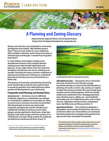
LAND USE TEAMID-228-WA Planning and Zoning GlossaryIndraneel Kumar, Regional Planner: GIS and Spatial AnalysisPurdue Center for Regional Development, pcrd.purdue.eduDid you ever drive by a new residential or commercialdevelopment and wonder, “Why did they locate itthere?” Have you ever looked at a new subdivision,office complex, institution, senior living community, orindustrial park and thought, “I wonder how long that’sbeen there”?In many Indiana communities, locating a newdevelopment involves a fairly complex decisionmaking process that includes legal checks andbalances. As you might expect, even the words thatdevelopers and planners use can be confusing to anoutsider. Knowing and using a common vocabulary ofplanning and zoning terms will help you understandplanning and zoning issues and communicate in abetter way.This glossary of commonly used planning and zoningterms should make it easier for you to get involvedin answering questions and making decisions aboutgrowth and development in your community.Frequently Used Planning and Zoning Termsaccessory use — Accessory uses are additional,incidental, supportive, or subordinate uses allowedon a land parcel in addition to its principal use. Often,accessory uses or accessory structures are permittedafter the principal structure was constructed,inspected, and approved, and the principal use isestablished. Examples of accessory uses includegarages, granny apartments, dog houses, urban beekeeping, small wind-energy conversion systems (5 to100 kilowatt), and solar energy systems for residences.See References and Resources items 20 and 14.A previous version of this publication was written by Val Slack,Purdue Extension Agricultural and Natural Resources educator.A cultivated farm field. See agricultural zoning.affordable housing — Housing for rent or ownershipthat costs 30 percent or less than the averagehousehold earnings or income of the administrative orplanning unit (such as a town, city, county, or a region)in which the housing is located. The costs include grossmonthly rent for rental properties, which can includeutilities and condominium fees. Mortgage payments,taxes, flood insurance, utilities, etc., are included forownership costs. For mobile home units, costs includesite rent, registration and license fees, and propertytaxes. See References and Resources item 31.agricultural district — One method to designate ageographic area to protect farmland from pressure toconvert it to other uses. These districts are voluntarilyformed by landowners and approved by governmentagencies for fixed, renewable time periods.The Purdue Land Use Team provides research-based resources andeducational programs for Extension professionals, governmentofficials, and residents on land use issues that affect theircommunities. Learn more at e.Purdue Extension Land Use — se
A Planning and Zoning Glossary ID-228-WLAND USE TEAMagricultural zoning — Local zoning that establishespermitted and conditional uses of land for agriculturalpurposes and supporting activities. Often, a low-densitydwelling unit (DU) is permitted on lands zoned foragriculture.conservation easement — A legal tool that enables aperson or entity to purchase or donate property for thepurpose of preserving natural amenities.development rights — These are the rights thatproperty owners have to develop their land under local,state, and/or federal laws.board of zoning appeals (BZA) — An appointed groupthat hears appeals and proposals and makes decisionsabout exceptions and variances to current zoningordinances.eminent domain — When a government acts in thepublic interest to take private property from an ownerwith just compensation.buffer zone — A parcel of land between twoincompatible land uses. A buffer zone can be usedas a transition zone, to protect ecological areas, as alandscape element, or to mitigate against nuisancessuch as noises. See References and Resources item 23.farmland base rate — A method of valuing farmlandthat is based on soil type and product markets ratherthan on development potential. It is used mostly forproperty tax purposes.fiscal impact — The effect that economic developmentor public policy has on local government finances.business district — Land that is zoned for commercialuse. A business district can be located linearly alonghighways and major thoroughfares, or a business districtcan be a contiguous group of parcels, such as a centralbusiness district, shopping district, etc.flood insurance rate map (FIRM) — An official map ofa community that includes the special hazard areas andthe flood risk premium zones defined by the FederalEmergency Management Agency (FEMA). The latestelectronic version of one of these maps is called a digitalflood insurance rate maps (dFIRM). See References andResources item 5.comprehensive plan — A guide for communitygrowth over a 10- to 20-year period. A comprehensiveplan provides the legal basis and support for land useregulations and direction. A comprehensive plan issometimes called a master plan or general plan.floodplain — A relatively flat area of land located besidestreams, rivers, or channels that can flood periodically.See References and Resources item 15.concentrated animal feeding operation (CAFO) — Alarge confined feeding operation (CFO) that has thepotential to discharge large amounts of pollutantsand has an option for a National Pollutant DischargeElimination System (NPDES) to meet state water qualityrequirements. There are currently minimal regulatorydifferences between CFOs and CAFOs in Indiana. SeeReferences and Resources item 18. See confined feedingoperation (CFO).form-based code (FBC) — A development regulationthat emphasizes an area’s built environment, urbanform, environmental and urban design, mixed uses,aesthetics, and public realm compared to emphasis oncompatibility of activities and separation of land uses aspracticed in conventional zoning. See References andResources items 35 and 36.confined feeding operation (CFO) — A livestockfeeding operation that consists of more than 300 cattle,600 swine or sheep, or 30,000 birds (chicken, turkey,etc.). This is the Indiana Department of EnvironmentalManagement’s definition. Counties often define CFOs bydifferent numbers. See References and Resources item18. See concentrated animal feeding operation (CAFO).conservation district — Conservation districts areestablished under the State Enabling Act. These districtsfocus on conserving soil, water, natural resources, andamenities at the local level. For example, state agencies,such as the Department of Natural Resources (DNR)can ask to create a conservation district to protect bathabitat to comply with the federal and state regulationsfor the endangered species. See References andResources item 24.A farm field borders the city. See buffer zone.2
A Planning and Zoning Glossary ID-228-WLAND USE TEAMgeneral plan — See comprehensive plan.green infrastructure — An interconnected systemof natural areas, conserved and working lands, openspaces, forests, streams, wetland and water bodies,riparian zones, and other landscape elements thatprovide ecological and environmental services to theregion. See References and Resources item 1.group quarters — A residential facility in whichunrelated people live. Examples include medicaltreatment facilities, prisons, dormitories, collegeresidence halls, military barracks, etc. They aresometimes called group homes. See References andResources item 25.hardship — When there is an undue burden on aproperty because of zoning regulations resulting insignificant or all loss of economic value. Hardship canresult from the shape, size, layout, and unique locationof the parcel. See References and Resources item 26.The floodplain of the Mississippi River. See floodplain. Photoprovided by NASA’s Earth Observatory.construction and safety standards. The termsmanufactured, modular, and mobile homes aresometimes used interchangeably. See References andResources item 22. See manufactured housing, modularhome.historic building — A building and property listedin the state or national historic register because ofits historic character, architectural style, associationwith a historic event, or landmark characteristics. SeeReferences and Resources item 27.modular home — Modular homes are built in a factoryand adhere to state, regional, or local building codes andregulations. See References and Resources item 22. Seemanufactured housing, modular home.impact fees — A monetary charge imposed on newdevelopment by a government unit to defray the capitalcosts of the infrastructure the new development willneed.net assessed value — A value that the county ortownship assessors place on land, buildings, andbusiness equipment minus deductions. See Referencesand Resources item 34.industrial district — Land zoned for light or heavyindustrial use. Helps segregate and consolidateindustries in one zone and protect from nuisance suits.nonconforming use — When a property’s use does notmeet zoning ordinance specifications.infill development — Development that occurs onvacant and underutilized properties and parcels aimedto increase the density and optimize use of the existinginfrastructure. See References and Resources item 14.nuisance doctrine — The legal doctrine that no ownerhas an absolute right to use property in a way that mightharm the public health or welfare, or that would damagea neighboring landowner's interest or the interests ofthe community as a whole.land trust — A private, nonprofit land organizationthat protects natural and cultural resources throughconservation easements, land acquisition, andeducation.overlay zoning districts — As the name suggests,overlay zoning districts are superimposed over existingconventional zoning district(s) and supersede any otherdevelopment regulations and ordinances. Examplesinclude a historic district, airport district, and interstateinterchange overlay district. See References andResources items 14 and 32.manufactured housing — Manufactured homes arebuilt in a factory (prefabricated), then transported toa site to assemble. These structures must follow theHousing and Urban Development (HUD) code formanufactured home construction and safety standards.See References and Resources item 22. See modularhome, mobile home.master plan — See comprehensive plan.petitioner — The person or entity who requests azoning change, a subdivision approval, or a zoningvariance.mobile home — A manufactured home built before1976, the year Housing and Urban Developmentimplemented a code for manufactured homeplan commission — An appointed group that developsa comprehensive plan and recommends zoning changesto local legislative boards.3
A Planning and Zoning Glossary ID-228-WLAND USE TEAMecosystems. A riparian zone is “water-dependent” landalongside streams, tributaries, and lakes. See Referencesand Resources item 12.planned unit development (PUD) — A single lot orgroup of few large adjacent lots that require masterplanning and a comprehensive development reviewprocess. PUDs are usually developed for residential andmixed use. They are sometimes commercial projects. SeeReferences and Resources item 13.planning — The legal process for deciding the futureuse of the land in a community.plat — A plat includes a map that shows subdivision lotsor property parcels. It is usually based on a land surveyand can include easements, utilities, rights of way,floodways, etc. See References and Resources item 29.prime farmland — Land that is best suited for row,forage, and fiber crop production. Natural characteristicsinclude level topography, good drainage, adequatemoisture supply, favorable soil depth and texture, andthe ability to consistently produce the most food, feed,and fiber with the least fertilizer, labor, and energy.Roads often run near land with unique scenic characteristics. Seescenic byway.property rights — A defined privilege to use land,water, and other resources in particular ways.scenic byway —A transportation corridor that hasunique historical, cultural, native, natural, and/or sceniccharacteristics. See References and Resources item 19.purchase of agricultural conservation easements(PACE) program — A government or nongovernmentalinitiative for acquiring the development rights tofarmland and preserving agricultural use. Landownersretain ownership of the land and agree to keep land inagricultural use. See purchase of development rights (PDR)program. See References and Resources item 37.site plan — A scaled drawing that includes detailedlayout of a development proposal and shows lot lines,access roads, rights of way, major landscape features,environmentally sensitive areas, existing and proposedutility easements, etc. See References and Resourcesitem 29.purchase of development rights (PDR) program —An initiative in which a government entity or landtrust purchases the development rights to farmlandto preserve agricultural use. In this voluntary program,landowners retain ownership of the land as long asthey agree to keep land in agriculture. See purchase ofconservation easements (PACE) program.subdivision control ordinance — A law that is a devicefor implementing the comprehensive plan. Subdivisioncontrols describe standards that communities must useto ensure orderly community growth and the properdivision of properties, plats, and tracts.taking — The act of acquiring and occupying landor regulating land to the extent that the land has noremaining economic value to the owner.remonstrator — A person or entity objecting to aproposed change in zoning.tax increment finance (TIF) district — An areadelineated and established by local governmentauthorities with the purpose to finance infrastructure toattract economic development, often through bonds.Infrastructure improvements include roads, water lines,sewers, utilities, and amenities. The bonds are repaidwith the increased property tax revenues that comeas a result of the infrastructure improvements thatincrease the district’s assessed value. See References andResources item 34.residential district — A zone established for housingthat can have various densities and varieties.restrictive covenant — A legal and written agreementbetween private landowners themselves and/or the cityto restrict and limit certain uses within a subdivision orplatted properties. Sometimes, it is also referred to asthe deed restriction. The objective of these covenantsis to protect the land value and character of thedevelopment. See References and Resources item 29.telecommuting — The act of working from home or abranch location and connecting to the primary placeof work by using a high-speed internet connection andriparian zone — This term describes a transition areabetween terrestrial ecosystems (land-based) and aquatic4
A Planning and Zoning Glossary ID-228-WLAND USE TEAMother communication devices. Telecommuting reducestransportation costs and travel distance. See Referencesand Resources item 29.transfer of development rights (TDR) — A programthat allows landowners to transfer the right to developone parcel of land to a more suitable parcel of land inorder to prevent farmland conversion and/or conserveopen spaces. TDR programs establish "sending or donorareas" and "receiving or donee areas" for developmentrights. See development rights.transient accommodation — A short-termaccommodation rental provided by private households.Airbnb, vacation rentals, and sometimes bed-andbreakfast providers can be included in this category.Local authorities may provide conditional use permitsand regulate them by collecting taxes, monitoring,and protecting residential areas from nuisances. SeeReferences and Resources item 30.There are regulatory differences for concentrated animal feedingoperations (CAFOs) and confined feeding operations (CFOs). Seeconcentrated animal feeding operation (CAFO) and confinedfeeding operation (CFO).transit oriented development (TOD) — In general, thisis a mixed-use development within walking distance (5to 10 minutes or a quarter of a mile) of a light rail or busrapid transit station. See References and Resources item21.walkable community — A community that providessafe, easily accessible, and highly connected biking andwalking infrastructure (such as sidewalks and bike lanes)for residents of all age groups. In such communities,daily activities (shopping, going to school or work, andrecreation) can be performed by using nonmotorizedtransportation modes. These communities promoteactive living. See References and Resources item 33.unified zoning ordinance — An ordinance that includeszoning ordinances and subdivision regulations forboth incorporated and unincorporated areas, into onedocument. See References and Resources item 26.wind energy conversion system (WECS) — A systemthat converts wind energy into usable electrical energyfor utilities and consumers. The ordinance coveringWECS generally identifies siting restrictions, setbacksfrom residential use and infrastructure, ancillary electricsubstations, preconstruction and post-constructionoperation and maintenance, and end of life removaland disposal of the wind turbines. See References andResources item7.unified development ordinance — An ordinance thatcontains zoning regulations, subdivision regulations,urban design guidelines, and accessories (such asfloodplain management, sign regulations, etc.) into onedocument. See References and Resources item 32.urban growth boundary — An area designated tocontain urban development within a planned urbanarea where land developments are permitted, and basicservices (such as sewers, water facilities, and policeand fire protection) can be economically provided.Sometimes called urban service boundary.zoning — A way of putting the comprehensive plan towork. A zoning ordinance contains regulations designedto implement the comprehensive plan. It includes,but is not limited to, permitted activities, setbacks,signs, parking, landscaping, environmental restrictions,density, and site plans. It provides for allowable landuses. Zoning is comprised of districts, ordinances, andthe zoning map.variance — A waiver to provide ease and relief fromordinance requirements and standards in case the landcannot be developed as allowed by zoning becauseits shape, proximity, location, topography, etc., causesundue economic hardship for the owner. Examplesinclude relaxing setback distances from the front, side,and back lot lines. See References and Resourcesitem 29.zero lot line dwelling unit — A building with a dwellingunit with at least one side resting directly on the lot line.See References and Resources item 26.viewshed — The geographical area and landscapevisible to an observer from a specific vantage point. SeeReferences and Resources item 28.5
A Planning and Zoning Glossary ID-228-WLAND USE TEAMThe ABCs of Planning and Zoning8. Scott Hutcheson. 1999. Plan Commission PublicHearings: A Citizen’s Guide. Purdue Extensionpublication ID-224-W. Available from the EducationStore, www.edustore.purdue.edu.As you travel your community highways and byways,look at the landscape. The changes you see affect youand all your neighbors now and in the future. Rememberthat your participation and understanding are the basisfor a strong community.9. Indiana Association of Cities and Towns, Associationof Indiana Counties, and Indiana PlanningAssociation. 1993. The Community PlanningHandbook. 1993. Indianapolis, Indiana.As you consider your community’s future, keep in mindthe ABCs of planning and zoning:A Attitude10. Indiana Continuing Legal Education Forum, IndianaBar Association Governmental Practices Section,and Indiana Planning Association, Inc. 1995. IndianaPlanning and Zoning Laws Annotated 1995 Edition.Charlottesville, VA: Michie Company.Open your attitude. A closed mind is a fertile field forconflict. Approach change in a professional way. Askquestions. Awareness is important.B Boards11. Indiana Land: Get Informed, Get Involved. 1997.Purdue Extension.Work with your local boards, state legislators, andplanning commissions. Offer ideas to improve thecommunity. Your community will benefit from yourinvolvement.C Collaboration12. Richard Kattlemann and Michael Embury. RiparianAreas and Wetlands, Sierra Nevada Ecosystem Project:Final Report to Congress. USGS, 1996. pubs.usgs.gov/dds/dds-43/VOL III/VIII C05.PDF.Community engagement is a critical component, andcollaboration is vital in a comprehensive planningprocess. And your part in caring for your neighborhoodis critical to its future.13. Daniel Mandelker. Planned Unit Development.American Planning Association. Planning AdvisoryService, 545, 2007.14. Marya Morris. Smart Codes: Model LandDevelopment Regulations. American PlanningAssociation. Planning Advisory Service Report, 556,2009.References and Resources1. Ole M. Amundsen, Will Allen, and Kris Hoellen.Green Infrastructure Planning: Recent Advancesand Applications. American Planning Association.Planning Advisory Service Memo, 2009.15. National Geographic Encyclopedia, n.2. Rick Chase. 1999. Agricultural Land Protection inIndiana. Purdue Extension publication ID-225-W.Available from the Education Store, www.edustore.purdue.edu.16. Val Slack. 1999. Citizen Participation in Land UsePlanning. Purdue Extension publication ID-226-W.Available from the Education Store, www.edustore.purdue.edu.3. Rick Chase and Scott Hutcheson. 1998. The Rural/Urban Conflict. Purdue Extension publication ID221-W. Available from the Education Store, www.edustore.purdue.edu.17. Val Slack. 1999. How Good Is Your ComprehensivePlan? Purdue Extension publication ID-227-W.Available from the Education Store, www.edustore.purdue.edu.4. T. Daniels and D. Bowers. 1997. Holding Our Ground:Protecting America’s Farms and Farmland. Washington,DC: Island Press.18. Alan Sutton, Don Jones, and Katie Darr. What is aCFO, CAFO? Purdue Extension publication ID-350-W.Available from the Education Store, www.edustore.purdue.edu.5. Flood Insurance Rate Map (FIRM), www.fema.gov/flood-insurance-rate-map-firm.19. The Indiana Byway Program. Indiana Department ofTransportation, www.in.gov/indot/2827.htm.6. Arthur B. Gallion and Simon Eisner. The Urban Pattern:City Planning and Design. 1980, D. Van NostrandCompany: New York.20. The Institute for Local Government. Understandingthe Basics of Land Use and Planning: Glossary ofLand Use and Planning Terms, Sacramento, CA.7. Erica Heller. Regulating Small-Scale Wind EnergySystems at the Local Level. American PlanningAssociation. Planning Advisory Service Report, 566,2011.6
A Planning and Zoning Glossary ID-228-WLAND USE TEAM21. Transit Oriented Development. American PlanningAssociation. Planning Advisory Service Essential InfoPacket, PAS-EIP 19, 2008.22. U.S. Department of Housing and UrbanDevelopment, FAQ, portal.hud.gov/hudportal/HUD?src /program offices/housing/rmra/mhs/faqs.23. Zoning Buffers: Solution or Panacea? ASPO PlanningAdvisory Service, Information Report No. 133, 1960.24. National Association of Conservation Districts, www.nacdnet.org/about-nacd/about-districts.25. Glossary, U.S. Census Bureau, /glossary.html.26. Unified Zoning Ordinance, 1998, The Area PlanCommission of Tippecanoe County, oe.pdf.27. The National Register of Historic Places, U.S.Department of the Interior, National Park vman/strevman6.htm.28. GIS Dictionary, Environmental Systems ResearchInstitute, rm/viewshed.29. Michael Davidson and Fay Dolnick. A PlannersDictionary. American Planning Association. PlanningAdvisory Service Report, 521/522.30. Leonard Cohen. The Sharing Economy: Airbnb andMunicipal Zoning Regulation, American PlanningAssociation, ning.pdf.31. Affordable Housing, U.S. Department of Housing andUrban Development, portal.hud.gov/hudportal/HUD?src /program offices/comm planning/affordablehousing.32. Property Topics and Concepts, American PlanningAssociation, topics.htm.This waterway has a transition zone between it and the farmland.See riparian zone.33. Marya Morris. Planning Active Communities.American Planning Association. Planning AdvisoryService Report, 543/544, 2006.34. Larry DeBoer. The Use of Tax Increment Financeby Indiana Local Governments. Rural IndianaStats, Purdue University, e-of-TaxIncrement-Finance.pdf.35. Donald Elliot, Matthew Goebel and Chad Meadows.The Rules That Shape Urban Form. American PlanningAssociation. Planning Advisory Service Report, 570,2012.36. Form-Based Codes Defined, Form-Based CodesInstitute, formbasedcodes.org/definition.37. Purchase of Agricultural Conservation Easements(PACE). Farmland Information Center. iew AFT FIC 2015 1.pdf.Find Out MoreFind other publications by the Purdue Land Use Teamin the Education Store (edustore.purdue.edu) or onthe Purdue Land Use Team website use).Sept. 2017It is the policy of the Purdue University Cooperative Extension Service that all persons have equal opportunity and access to its educational programs, services, activities, andfacilities without regard to race, religion, color, sex, age, national origin or ancestry, marital status, parental status, sexual orientation, disability or status as a veteran.Purdue University is an Affirmative Action institution. This material may be available in alternative formats.LOCAL FACESCOUNTLESS CONNECTIONS1-888-EXT-INFO www.extension.purdue.eduOrder or download materials fromPurdue Extension The Education Storewww.edustore.purdue.edu
Purdue Center for Regional Development, pcrd.purdue.edu A previous version of this publication was written by Val Slack, Purdue Extension Agricultural and Natural Resources educator. affordable housing — Housing for rent or ownership that costs 30 percent or less than the average household earnings or income of the administrative or