Transcription
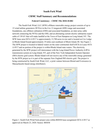
South Fork WindCRMC Staff Summary and RecommendationsFederal Consistency – CRMC File 2018-10-082The South Fork Wind, LLC (SFW) offshore renewable energy project consists of up to15 wind turbine generators (WTGs) in the 6 to 12 megawatt (MW) range and associatedfoundations, one offshore substation (OSS) and associated foundation, an inter-array cablenetwork connecting the WTGs and the OSS, and an alternating current electric submarine exportcable of 138 kV that will make landfall at the Town of East Hampton on Long Island, NY. TheSFW lease area OCS-A 0517 is approximately 13,700 acres in size and is located on Cox Ledgein Rhode Island Sound approximately 19 miles east-southeast of Block Island, RI. See Figure 1.The SFW project is located in federal waters on the outer continental shelf (OCS) in Lease OCSA 0517 and no portion of the project is within Rhode Island state waters. The electricitygenerated by the SFW project will interconnect with the Long Island Power Authority (LIPA)transmission system on Long Island, NY, part of the New York Independent System Operator(ISO) electric grid system. Rhode Island will not receive any of the renewable energy generatedby the SFW project as it is part of the separate New England ISO electric grid. The project isbeing constructed by South Fork Wind, LLC, a joint venture between Ørsted and Eversource (aMassachusetts based energy distributor).Figure 1. South Fork Wind Farm project area within BOEM lease assignment OCS-A 0517 asapproved on March 23, 2020. Source: BOEM1
The CRMC has federal consistency review authority for the SFW project pursuant to theCoastal Zone Management Act (CZMA) at 16 U.S.C. §§ 1451 et seq., and the CZMA regulationsat 15 C.F.R. part 930, subpart E, because Rhode Island has a federally-approved coastalmanagement program, the project is a listed federal activity with coastal effects, and the projectis located within the CRMC geographic location description (GLD 2011) that is coincident withthe Ocean SAMP boundary, as approved by the National Oceanic and AtmosphericAdministration (NOAA) Office of Coastal Management. The CRMC’s enforceable policiesapplicable to the SFW project are found in the Ocean SAMP as codified in the Rhode IslandCode of Regulations at 650-RICR-20-05-11.10.SFW filed a consistency certification with the CRMC on October 22, 2018, pursuant tothe federal consistency regulations 15 C.F.R. §§ 930.57 and 930.76(a)(2), stating “[t]he proposedactivity complies with the enforceable policies of the Rhode Island approved managementprogram and will be conducted in a manner consistent with such program.” See SFWConstruction and Operation Plan (COP) Appendix A. SFW provided responses to each of theOcean SAMP § 11.10 enforceable policies. For purposes of this summary document only theenforceable polices at issue are included herein with the CRMC staff analysis. Thecorresponding SFW responses combine both the wind farm (SFWF) and export cable (SFEC)responses from Appendix A. This abbreviated CRMC staff analysis is a portion of the fullanalysis as contained within the draft federal consistency decision, which will not be completeduntil after Council action in the SFW matter on May 25, 2021.Ocean SAMP Enforceable Policy Issues§ 11.10.1(C)Offshore developments shall not have a significant adverse impact on the naturalresources or existing human uses of the Rhode Island coastal zone, as described in the OceanSAMP. In making the evaluation of the effect on human uses, the Council will determine, forexample, if there is an overall net benefit to the Rhode Island marine economic sector from thedevelopment of the project or if there is an overall net loss. Where the Council determines thatimpacts on the natural resources or human uses of the Rhode Island coastal zone through thepre-construction, construction, operation, or decommissioning phases of a project constitutesignificant adverse effects not previously evaluated, the Council shall, through its permitting andenforcement authorities in state waters and through any subsequent CZMA federal consistencyreviews, require that the applicant modify the proposal to avoid and/or mitigate the impacts orthe Council shall deny the proposal. (Emphasis added.)SFW Response: The SFWF (and SFEC) is consistent with this policy. The SFWF (andSFEC) will not have significant adverse impact on the natural resources or human uses of the RIOcean SAMP study area. It is expected that current activities will be able to continue postconstruction.2
CRMC Analysis: The first part of the enforceable policy requires that the Councildetermine whether “there is an overall net benefit to the Rhode Island marine economic sectorfrom the development of the project or if there is an overall net loss.” Table 4.6.1 SocioeconomicRegion of Influence Communities of the SFW COP indicates that Rhode Island could be apotential location for an operation and maintenance facility and that Providence may beconsidered as a port facility for assembly, staging and logistics for the SFW project. See SFWCOP at 4-339. In addition, Table 4-1 of the Economic Development and Jobs Analysis for theSouth Fork Wind Farm and the South Fork Export Cable shows the total jobs and value addedvalues for both the total U.S. and the state of New York only. The total value added impact (in2018 dollars) of the SFW project will be 57.1 million for New York and 213.2 million for theUnited States during the expected two-year construction phase and a total value added impact of 3.9 million for New York and 9.5 million per year for the United States during the operationsphase. The COP and the Appendix analysis report do not attribute any direct economic benefitsspecifically to the State of Rhode Island. See SFW COP Appendix AA(https://www.boem.gov/Appendix-AA/). Thus, neither the COP nor Appendix AA attribute anydirect economic benefits to the state of Rhode Island as a result of the SFW project. Given thelack of economic information within the COP, CRMC staff inquired of the applicant as towhether there were any direct economic benefits to the state from the SFW project and receiveda document from Ørsted titled “South Fork Wind (SFW) estimated economic impact to RI,”dated April 15, 2021. It reports that the SFW project’s impact on RI economic development isestimated to be approximately 33 million in local investment and approximately 134 local jobs.These projections are based upon economic development plans that include development andprocurement efforts to date as well as committed and planned investments by Ørsted, whichapparently have been reviewed by RI Commerce.As shown in the CRMC South Fork Wind - Coastal Effect Analysis the net combinedtotal of commercial, charter and recreational fishing economic exposure value for Rhode Islandattributable to the SFW lease area over the 30-year project lifetime is estimated at between 30,141,258 and 50,473,735. Ørsted has acknowledged that there could be up to a 100% loss ofcommercial landings during some portions of construction and decommissioning phases for theSFW project, and only acknowledges a 5% loss during the 25-year operational phase. TheCRMC Fishermen’s Advisory Board (FAB), however, has estimated that there will be at least100% losses during all construction and decommission phases and between 50-80% losses tocommercial, charter and recreational fishing revenues during the 25-year operational phases. Theestimated potential losses to the Rhode Island economy over the life of the SFW project usingthe FAB 50-80% losses for both SFW and FAB economic data could range from 15,070,629upwards to 40,378,988. Accordingly, based on the estimated 30-year project lifetime economicexposure range, the FAB estimated losses could be substantial to the RI economy and equal orexceed Ørsted’s SFW project RI economic development impact estimated at approximately 33million. Therefore, given the uncertainties of Ørsted’s economic estimate and the FABestimated potential losses, CRMC staff cannot determine whether there will be an overall3
net benefit to the Rhode Island marine economic sector from the SFW project or if therewill be an overall net loss.The second part of the enforceable policy requires that “the applicant modify the proposalto avoid and/or mitigate the impacts or the Council shall deny the proposal.” In the case offederal consistency, as in this matter, the Council would object to the project consistencycertification in the event significant adverse effects from the project cannot be avoided ormitigated in accordance with the CRMC enforceable policies. The Bureau of Ocean EnergyManagement (BOEM) is the lead federal agency for the permitting of offshore wind projects infederal waters. BOEM issued a Draft Environmental Impact Statement (DEIS) for the SFWproject on January 8, 2021 and it describes a number of potential unavoidable impacts tocommercial fisheries and for-hire recreational fishing interests resulting from the SFW project asspecified within Section 4.1.1 of the DEIS. These unavoidable impacts include:1. A disruption to access or temporary restriction in port access or harvesting activities dueto construction of offshore project elements;2. A disruption to harvesting activities during operations of offshore wind facilities;3. Changes in vessel transit and fishing operation patterns; and4. Changes in risk of gear entanglement or target species.See BOEM DEIS at 4-1.Indeed, the temporary displacement of commercial fishing activity did occur during theconstruction and installation phase of the Block Island wind farm in 2015 and 2016. As notedabove BOEM anticipates disruption to commercial fishing harvesting activities during operationsof offshore wind facilities, and the operational period of the SFW project is 25 years. The FABhas indicated that there will be changes in vessel transit and fishing operations as a result of theSFW project. And further, the FAB has indicated that there will be risk of gear entanglement dueto wind farm construction vessels and the turbine foundations. As explained in the CRMC SouthFork Wind - Coastal Effect Analysis commercial fixed gear fishermen (e.g., lobster pots andgillnets) will lose 40% or more of their gear sets conforming to a 1 x 1 NM uniform grid turbinewind farm layout as compared to current operations, as the fixed gear will only be set in betweenturbine foundations and only along the east-west rows of turbines so that mobile gear operationstowing nets or dredges can operate the clear lanes between the rows of turbines.As noted below in the discussion for § 11.10.2(B), the currently proposed SFW projectincludes up to 16 foundations (15 turbines, 1 OSS) in a 1 x 1 NM uniform east – west grid thataligns with the southern New England regional grid proposed by the offshore wind industry. TheSFW project is located on a terminal glacial moraine. See COP at 4-79. It is a location rich withspecies and a complex benthic habitat, known as Cox Ledge, and has many similar attributes andcharacteristics as CRMC designated area of particular concern (APC) located within state watersas described in Ocean SAMP § 11.10.2(A). Cox Ledge is designated on nautical charts and incharter fishing brochures. The applicant asserts that current fishing activities will be able to4
continue once construction of the SFW project is completed (COP Appendix A-2). Thedeveloper expects that there will disruption to current fishing activities during projectconstruction as well as during the decommissioning phase.Direct impacts during the geophysical surveying, construction and decommissioningphases would affect commercial fishing, charter and recreational fishing, sightseeing and indirectshore side impacts. The addition to up to 16 foundations and cable armoring where cable burialcannot be achieved will introduce structure to the environment that creates adverse impacts toexisting Rhode Island based coastal uses. The introduction of physical structure in the watercolumn has a high probability to disrupt the ecosystem as has been observed at the Block IslandWind Farm and wind farms in Europe. Cox Ledge is one of the few remaining places in RhodeIsland Sound that Atlantic cod are found at all life stages and the area is heavily targeted bycharter and recreational fishing due to the current species diversity that is not found in otherlocations within the region. The bottom structure and habitat of the South Fork lease area aresimilar to the CRMC designated APC within state waters. In addition, it is an area of significanceto the charter and recreational fishery as well as to commercial fishing operations. As such, theCRMC enforceable policies for APC presumptively excludes all offshore development withinsuch areas. See further discussion below regarding CRMC enforceable policy § 11.10.2.Pre-construction geophysical surveys were conducted to support the development of theSFW COP, and further survey vessel activity continues especially along the export cable routeand in support of other planned offshore wind farms. The CRMC received numerous reports overthe last 2 years of survey vessel operations impacting Rhode Island based commercial fishingvessels and fixed gear. Apparently, similar incidents from multiple states have been reported atvarious public meetings including the BOEM public scoping sessions of conflicts of the surveyvessels with fixed commercial fishing gear. The survey vessel interactions included the loss offixed gear and the displacement of mobile gear fishing activity during active geophysicalsurveys. Decreased fishing activity yield was also reported in the vicinity of the survey vessels,but recovery to recent catch levels was reported after the survey vessels exited an area. Thisindicates a temporary, but significant impact to Rhode Island based commercial fishing activityduring the pre-construction phase of the proposed project.During construction and decommission phases the CRMC expects significant disruptionto existing Rhode Island based coastal uses and resources. The proposed 16 foundations areexpected to be installed at a rate of one every 2-4 days at a time of the year to optimizeavoidance of disruption to sensitive marine mammals like the Right whale. Pile driving offoundations is anticipated within the SFW COP to be 2-4 hours per pile, and the noise impactfrom the pile driving will be transmitted along the ocean sediment interface and to a less degreein the water column after being somewhat mitigated by noise mitigation bubble curtains.Nevertheless, it is expected as shown in Appendix J of the Cop that mortality to fish, eggs andlarvae will occur around each pile, which will be an adverse impact. The disruption to the marinehabitat is not confined to the lease area, but is governed by the nature of the substrate. The5
additional vessel activity in the area will introduce local mechanical disruption to the benthosand water column but also increase the ambient noise levels in the water column.The construction activity includes the displacement of approximately 255 acres ofexisting boulders within the South Fork lease and along the export cable route that will changethe benthic landscape for Rhode Island commercial fishermen who have been working thesewaters for decades. See SFW COP at 3-13. Some of these boulders within the SFW lease areaare significantly large at up to 32 feet in diameter. Id at 4-79. Unless the developer providesdetailed reports on boulder re-location, the commercial fishermen will be faced with additionalchallenges if and when they return to harvesting activities within these disturbed areas. As apoint of reference, the installation of the Block Island Wind Farm did not meet its plannedinstallation schedule, and was completed following significant delays. With the complexity ofglacial deposits at the South Fork site, the possibility exists that the installation schedule willencounter delays and significant installation challenges, especially because the SFW project isfarther offshore than the BIWF. The impacts of construction and decommissioning are expectedto be significant, but constrained temporally with the recovery to the benthos expected to occurwithin several years under natural forcing conditions.As specified in the coastal effects analysis section, construction noise, especially frompile driving will have significant impacts to marine life. Pile driving noise will be lethal to fish,eggs and larvae over 10 acres surrounding each pile foundation for a total of 163 acres even withthe proposed 10dB noise attenuation. And the potential cumulative exposure for fish, eggs andlarvae may be up to 7455 acres or 54% of the SFW lease area, which is significant. Given thegeological complexity of the glacial moraine within the SFW lease area, it would seem prudentto consider that many of the pile foundations are likely to be difficult installations, which wouldincrease the cumulative potential lethal effects of pile driving. This scenario could potentiallyhave serious consequences on the survivability of multiple fish species eggs and larvae duringspring when pile driving is scheduled to commence as early as May 1 and could result in asignificant impact to a year class of important species relied upon by Rhode Island basedcommercial and recreational fishing interests. In addition, the SFW COP shows the behavioraleffects threshold for fish from the expected pile driving activity to be 41,818 feet (7.9 miles)beyond the pile being driven. See COP at 3-23. Thus, the effects to fish behavior could extendalmost 8 miles beyond the lease area. Given that the pile foundation driving is limited to theperiod of May 1 to December 31 and the SFW COP indicates pile driving will occur over aperiod of 4 months and it is estimated that fish will return to an area impacted by pile drivingnoise after 2 months, it is expected that commercial and recreational fishing activity will beadversely impacted over the spring, summer and fall fishing seasons.During the operational period, the SFW turbine and OSS foundation structures willremain in place causing alterations to existing Rhode Island based fishing activities. As discussedin CRMC’s federal consistency concurrence for the Vineyard Wind 1 project, Rhode Islandcommercial fishermen proposed an east-west uniform grid wind farm layout with minimum 1 by1 nautical mile spacing and transit corridors. The CRMC stated that this would allow continued6
harvesting by most commercial fishing with the necessity of modifications and adjustments tofishing gear and operations, which was a compromise by the fishing industry in an effort to adaptto wind farm structures and anticipated wind farm plans. In November 2019 the offshore windindustry holding leases in the southern New England OCS collaboratively joined together topropose a 1 by 1 NM uniform grid for this contiguous wind development area of approximately1400 square miles. The SFW COP was modified again in February 2020 after an initialsubmission in 2018 to conform to this industry proposed southern New England regional windfarm layout. While the turbine spacing for each project may be wider than the developer’soptimized spacing and layout, the size of commercially available wind turbine generators hasincreased allowing developers to reduce the infrastructure necessary to meet a specific projectpurpose and need. Nevertheless, the BOEM Supplemental Environmental Impact Statement(SEIS) for the Vineyard Wind 1 project indicates that even with the wind farm projectconforming to the 1 x 1 NM uniform grid layout there will be moderate impacts to commercialfisheries and For-Hire recreational fishing operations. Moreover, BOEM’s analysis anticipatesthat there will be major impacts to commercial fisheries and For-Hire recreational fishingactivities following reasonably foreseeable future wind farm construction in the region. In fact,the recently issued Record of Decision (ROD) for the Vineyard Wind 1 project states “it isanticipated that there will be negative economic impacts to commercial fisheries. WhileVineyard Wind is not authorized to prevent free access to the entire wind developmentarea, due to the placement of the turbines it is likely that the entire 75,614 acre area will beabandoned by commercial fisheries due to difficulties with navigation.” See Vineyard WindROD at 39 ities/final-record-decisionvineyard-wind-1). Accordingly, the CRMC expects that Rhode Island based coastal uses will beadversely affected and not able to continue at existing operational levels during the SFW project25 year operational period.The current so-called “gentlemen’s agreement” within the Rhode Island commercialfishing community sets up alternating fixed and mobile gear lanes of operation on a 0.5-0.6 NMeast-west grid within Rhode Island Sound. The addition of wind turbine foundation infrastructureon a 1 x 1 NM uniform grid will reduce the area available for fixed gear fishing by up to 50percent. The risk of allision may require fishing operations to hire additional crew specificallyfor navigation within the wind farm and during transit when adverse weather, including fog, isexpected. The interference impacts of the turbine foundation structures on vessel radar increasesthe risk of both collision and allision within the wind farm particularly in adverse visibility andpoor weather conditions. Rhode Island based fishing vessels may choose to avoid the SFWproject area when a vessel captain deems it unsafe to navigate within the area either for fishingactivity or transiting to other fishing grounds. In adverse weather conditions, vessel transit maybe require to be routed around the SFW project for safety concerns. Insurance underwriters forcommercial and recreational fishing may deem that the safety and property risks are too great forthem to offer policy coverage at any rate for vessels operating within or around the SFW projectarea. Rhode Island based commercial fishermen may not be able to harvest within the SFWproject in adverse weather without significantly modifying their navigation electronics or adding7
crew for safe operations. In addition, NOAA will not be able to continue their stratified randomfishery stock assessment surveys in the SFW project area because of safety concerns, especiallydue to vessel clearance with wind turbine rotor sweep. This may result in a reduction of NOAANMFS harvest quotas assigned to Rhode Island commercial fishermen. And, if the fishermen aredisplaced from the SFW project area, the fishing pressure on the fishery resources outside of theproject area could be impacted with resources and harvesting income being divided amongstmore fishing vessels resulting in lower catch and revenues. This situation could result in acascading effect that may point to the need for a reduction in the overall commercial fishing fleetto allow some commercial fishing businesses to remain solvent.Rhode Island charter (For-Hire) and recreational fishing specifically target Cox Ledge forspecies diversity, particularly Atlantic cod and large highly migratory game fish. Thecombination of the bottom structure and the current dynamics creates an environment thatattracts sport fish of interest including, but not limited to, Atlantic cod, tuna, pollock and sharks.Many charter businesses state “if you can’t find fish elsewhere, head to Cox Ledge,” they alsostate that the weather is a significant factor for a trip to Cox Ledge. Because of its popularityseveral recreational angler forums have dedicated channels for Cox ledge and what is beingcaught out there. A potential impact for charter and recreational anglers is for the large pelagicsport fish to use the foundations as cover. With the large amount of line out over the hours tryingto land a large fish such as a tuna or shark it is unlikely if these Rhode Island based coastal useswould continue to fish within the SFW lease area on Cox Ledge due to the potential to lose alarge hooked fish. In fact, the SFW COP Navigation Safety Risk Assessment states “drift fishingand trolling are common recreational fishing techniques used on Cox Ledge. There is thepossibility that fishing lines or other gear may catch on Project structures or scour protectionaround the base of the foundation and be damaged or lost.” See SFW COP Appendix X at 74(https://www.boem.gov/Appendix-X/).The Rhode Island charter and recreational fisheries has a significant landside indirectcomponent and can contribute to the tourists wrapping up their trip by purchasing seafood atdockside from the other commercial fishermen to round out their Rhode Island experience. Andwhile the proposed SFW project is almost entirely in federal waters it is located in a regionfished by Rhode Island based fishermen and frequented by recreational anglers from areasoutside of Rhode Island. As noted above, it is estimated that the combined economic exposurefor both charter and recreational economic impacts to Rhode Island that are attributable over the30-year lifetime from the SFW lease area is estimated at between 17,777,334 and 27,880,012.Significant impacts to existing charter and recreational fishing operations will likely occur fromthe development and operation of the project. Accordingly, even a 50% loss of charter andrecreational fishing economic exposure over the life of the SFW project would be significant tothe state of Rhode Island ranging from 8,888,667 to 13,940,006.BOEM’s SEIS for the Vineyard Wind 1 project indicates that for the entire region, thedevelopment of wind farms will result in continuous, long-term minor to moderate direct andindirect impacts to marine based businesses due to the presence of the new structures on the8
OCS. See BOEM VW SEIS at ES-5 nd-1supplement-eis). BOEM has considered the regional economic benefits of supply chain and theimpact of developing renewable energy resources into their analysis. The VW SEIS lists thepotential direct impacts as entanglement, gear loss/damage, navigational hazards and risk ofallision, fish aggregation, habitat alteration, effort displacement and space use conflicts.Climate change is shifting species northward including Black Sea Bass, Scup and theAmerican Lobster (RIDEM 2021). Despite this regional species shift, fishermen and ongoingmonitoring (discussion at RI MFI fall 2019 meeting, 2021 communication from RI DEM,NEFMC 2020, Zemeckis et al. 2014) are observing increases in Atlantic cod near Cox Ledge.Sufficient spatial and temporal data do not exist to properly characterize the spawning activity(DeCelles et al. 2017). Metapopulation structure has been identified at fine spatial scales and islikely critical to the survival of the overall stock (McMannus 2021). A distinct southern NewEngland cod stock has been found to exist on Cox Ledge with spawning known to occur betweenNovember and January and from February to April. Recreational angling for Atlantic cod isimportant on Cox Ledge and recreational angler reports support a significant increase inpopulation over the past 15 years (Sheriff 2018). Early life stage Atlantic Cod require boulder,cobble and pebble substrates and return to the same spots to spawn (Zemeckis et al. 2017).Spawning is sensitive to disturbance (Dean et al. 2012). Given the available data, it appears thatthe SFW area holds unique traits that serve as a refuge for all life stages of Atlantic cod as wellas a unique cod population that is growing in number compared to the regional trend ofpopulation decline.The proposed SFW project will add structure to the area that extends through the watercolumn with a significant potential to alter the species composition of the fish targeted on CoxLedge and beyond. For each fish caught, there are several orders of magnitude of juvenile andlarval stages that failed to survive to harvest and the same mortality applies to the prey of thesefish (e.g. Andersen et al. 2016; Sprules and Barth 2016; Sheldon et. al. 1972, Peters 1983;Sheldon and Parsons 1967). Each fish caught represents millions of early life stage individuals.The addition of structure throughout the water column will alter the ecosystem and theecosystem dynamics by altering both the initial and boundary conditions for every species atevery developmental life stage. It has been observed that wind farm foundations providestructure for blue mussels to colonize (Block Island Wind Farm and European Wind Farms). Theblue mussels deplete the phytoplankton biomass in the water. Fisheries species abundance inhighly sensitive to phytoplankton biomass (e.g. Large et. al. 2015; Friedland et.al. 2019) andserves as a marker of ecosystem health. The structure provides refuge as well as feeding groundsfor mobile species. Mavraki et al. (2021) studied the reef effect of wind farms and found thatbenthopelagic and benthic species utilize the structures as a feeding ground for the colonizingorganisms and for undetermined reasons (digestive tract analysis revealed not all species wereconsuming fouling fauna), however their study indicated that pelagic species residence time wasnot increased. Ecosystem dynamics within wind farms is not well known and wind farmsconstructed on top of productive regions for early life stage and bio-diversity are not yet reportedor studied. There also is a significant concern that sufficient baseline data to understand these9
changes does not exist for the South Fork area. With the level of surveying activity currentlyunderway, it is not possible to obtain a clean and undisturbed ecosystem assessment for the area.Observations at the BIWF document a shift in species around the turbine foundations.The dominant species is Black Sea Bass, a species targeted by the inshore recreational fishermen.An increase in large sport fish has not been observed, but an increase in recreational fishing hasbeen witnessed at the
SFW lease area OCS-A 0517 is approximately 13,700 acres in size and is located on Cox Ledge in Rhode Island Sound approximately 19 miles east-southeast of Block Island, RI. See Figure 1. The SFW project is located in federal waters on the outer continental shelf (OCS) in Lease OCS- . 2021 and it describes a number of potential unavoidable .