Transcription
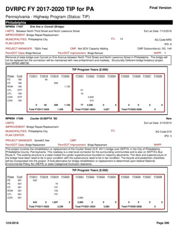
Final VersionDVRPC FY 2017-2020 TIP for PAPennsylvania - Highway Program (Status: TIP)PhiladelphiaMPMS# 17407Erie Ave o/ Conrail (Bridge)LIMITS Between North Third Street and North Lawrence StreetIMPROVEMENT Bridge Repair/ReplacementEst Let Date: 7/12/2018FC:MUNICIPALITIES: Philadelphia City14AQ Code:NRSPLAN CENTER:IPD: 6PROJECT MANAGER: TSS/H. FreedCMP: Not SOV Capacity AddingPennDOT Class: Bridge RemovalCMP Subcorridor(s): 5G, 14APennDOT Improvement: Bridge RemovalNHPP: YRemoval of state bridge over Conrail on Erie Avenue between North Third Street and North Lawrence Street in Philadelphia. The bridge willnot be replaced but the connection will be maintained with new embankment and roadway. Structurally Deficient bridge breakout projectfrom MPMS #88706.TIP Program Years ( al FY2017-2020MPMS# 17409FY20231,1501,459774,550Total FY2021-2024004,627000Total FY2025-202800Coulter St/SEPTA *B2NewLIMITSEst Let Date: 3/15/2019IMPROVEMENT Bridge Repair/ReplacementFC:MUNICIPALITIES: Philadelphia CityPLAN CENTER:IPD: 5PROJECT MANAGER: Gannett/S. NewPennDOT Class: Bridge ReplacementAQ Code:S19CMP:PennDOT Improvement: Bridge ReplacementNHPP:This project involves the rehabilitation or replacement of the Coulter Street (S.R. 4011) bridge over SEPTA, in the City of Philadelphia,Philadelphia County, Pennsylvania. This roadway is a vital local connector for the surrounding communities and is also on SEPTA’s BusRoute K. The existing structure is a steel riveted thru girder superstructure founded on masonry abutments. The deck and superstructure ofthe bridge have been rated to be in poor condition with the substructure rated to be in fair condition. The bicycle and pedestrian checklistswill be incorporated into the project. A final alternative for bridge rehabilitation or replacement is determined upon federal NationalEnvironmental Policy Act (NEPA) or state Categorical Exclusion clearance.TIP Program Years ( 24FY2025FY2026FY2027FY20283,5826420Total FY2017-202012/6/2018FY20201,6972,33903,5820Total FY2021-202403,582000Total FY2025-2028000Page 290
Final VersionDVRPC FY 2017-2020 TIP for PAPennsylvania - Highway Program (Status: TIP)PhiladelphiaMPMS# 17460Return40th Street Bridge Over Amtrak/SEPTA SR:7301LIMITS Over Amtrak/SEPTAIMPROVEMENT Bridge Repair/ReplacementNo Let DateFC:MUNICIPALITIES: West PhiladelphiaAQ Code:S19PLAN CENTER:IPD:PROJECT MANAGER: TSS/GANNETTPennDOT Class: Bridge ReplacementCMP: Not SOV Capacity AddingCMP Subcorridor(s): 7APennDOT Improvement: Bridge ReplacementNHPP:The existing bridge (built in 1915) has two lanes, shoulders, and sidewalks on both sides. It currently has a 3-ton weight restriction, forcingthe detour of two SEPTA bus routes. The new bridge will also have two lanes, shoulders, and sidewalks on both sides. The bicycle andpedestrian checklists will be incorporated into the project.A final alternative for bridge rehabilitation or replacement is determined upon National Environmental Policy Act (NEPA) clearance.TIP Program Years ( UTLCONLOCSTP44FY20170FY2018935FY20190Total FY2017-2020MPMS# otal FY2021-202400FY20260FY2027FY20280Total FY2025-202800City Ave o/ SEPTA (Bridge)LIMITS over SEPTA Cynwyd LineIMPROVEMENT Bridge Repair/ReplacementEst Let Date: 8/13/2020FC:MUNICIPALITIES: Lower Merion Township; Philadelphia City14AQ Code:S19PLAN CENTER:IPD: 2PROJECT MANAGER: TSS/S. HasanPennDOT Class: Bridge ReplacementCMP: Not SOV Capacity AddingCMP Subcorridor(s): 5F, 7APennDOT Improvement: Bridge ReplacementNHPP: YThis project involve rehabilitating or replacing the state bridge over the SEPTA rail lin on City Avenue (US 1) between Bala Avenue andBelmont Avenue in the City of Philadelphia. Structurally Deficient bridge breakout project from MPMS #88706. A final alternative for bridgerehabilitation or replacement is determined upon federal National Environmental Policy Act (NEPA) or state Categorical Exclusion clearance.TIP Program Years ( 28546365Total FY2017-202012/6/2018FY2019009115,6420Total FY2021-202405,642000Total FY2025-2028000Page 291
Final VersionDVRPC FY 2017-2020 TIP for PAPennsylvania - Highway Program (Status: TIP)PhiladelphiaMPMS# 17521NewPine Road Bridge over SEPTA (Act 13)LIMITS Pine Road Bridge over SEPTAIMPROVEMENT Bridge Repair/ReplacementNo Let DateFC:MUNICIPALITIES: Philadelphia CityAQ Code:S19PLAN CENTER:IPD:CMP:PROJECT MANAGER:PennDOT Class:PennDOT Improvement:NHPP:The Pine Road Bridge over SEPTA’s (abandoned) Newtown Branch, north of Rhawn Street in Fox Chase (City Bridge No. 194), isdesignated as Structurally Deficient (SD) with a weight restriction for 20 tons and a sufficiency rating of 62, and requires a full superstructurereplacement.TIP Program Years ( 20281602,00002400Total FY2017-2020MPMS# 17657FY202016040002,000Total FY2021-2024002,000000Total FY2025-202800ReturnMarket Street Signal and Pedestrian Improvements SR:3010LIMITS 46th Street to 63rd StreetIMPROVEMENT Bicycle/Pedestrian ImprovementNo Let DateFC:MUNICIPALITIES: West PhiladelphiaPLAN CENTER:IPD:PROJECT MANAGER: TWB/VLFPennDOT Class: Safety ImprovementAQ Code:R2CMP: Not SOV Capacity AddingCMP Subcorridor(s): 10APennDOT Improvement: Safety ImprovementNHPP: YInstall pedestrian crosswalks at 17 intersections beneath SEPTA's Market St. Elevated Line, modernize the traffic signals, and lengthen theleft turn standby lane on Market St. where possible.TIP Program Years ( 9Total 220Total FY2021-2024FY2023FY2024000FY20250FY20260Total FY2025-2028FY2027FY2028000Page 292
Final VersionDVRPC FY 2017-2020 TIP for PAPennsylvania - Highway Program (Status: TIP)PhiladelphiaMPMS# 17697Island Avenue Signal Upgrade SR:3013LIMITS Woodland Avenue to Bartram AvenueIMPROVEMENT Signal/ITS ImprovementsEst Let Date: 3/1/2018FC:MUNICIPALITIES: Philadelphia CityPLAN CENTER:14AQ Code:NRSMetropolitan SubcenterIPD: 7PROJECT MANAGER: TWB/V. FleyshPennDOT Class: Safety ImprovementCMP: Minor SOV CapacityCMP Subcorridor(s): 4C, 6BPennDOT Improvement: Safety ImprovementNHPP:Upgrade the signal controls at six intersections including incidental stormwater improvements, incorporating preference for SEPTA Route 36;narrow the roadway to accommodate pedestrians; and simplify three intersections. This project location is included in Philadelphia’s BikeNetwork and is rated BF (Bike Friendly - wide shoulders or lanes)TIP Program Years ( NLOC2,2801,613FY20180Total FY2017-2020MPMS# FY20240Total FY2021-2024FY2025000FY20260FY2027FY20280Total FY2025-202800I-95 & Aramingo Ave., Adams Ave. Connector SR:1007LIMITS Betsy Ross Bridge to Torresdale Ave.IMPROVEMENT Intersection/Interchange ImprovementsActl Let Date: 11/10/2016MRPID:68FC:MUNICIPALITIES: Near Northeast Philadelphia16AQ Code:2020MPLAN CENTER:IPD: 6PROJECT MANAGER: EE/E. ElbichPennDOT Class: Highway ReconstructionCMP: Major SOV CapacityCMP Subcorridor(s): 4BPennDOT Improvement: Highway ReconstructionNHPP:This project will extend Adams Avenue (SR 1026), which is located east of Tacony St. and south of Torresdale Avenue, to Aramingo Avenueand ramps constructed as part of the I-95, Delaware Expressway at Betsy Ross Bridge Interchange project. The extension will provide aconnection between Torresdale Avenue and Aramingo Avenue and I-95 at the Betsy Ross Interchange. It will be a new roadway that is onelane per direction, but it will widen out towards the Betsy Ross Interchange to accommodate additional turn lanes, etc. There will be trafficsignals at Torresdale Avenue and Aramingo Avenue. Adams Avenue will pass under the AMTRAK bridge, but no bridge work is anticipated.The exact limit at the interchange will be determined by the Section BRI/BSR projects and how they complete the interchange. Additionally,the parallel portion of the Frankford Creek Greenway will be constructed adjacent to the Adams Avenue Connector.Project CMP (Congestion Management Process) commitments include strategies such as improvements for transit users, bicyclists,pedestrians, and drivers on the existing road network (operations). See DVRPC’s 2012 annual memoranda on supplemental strategies fordetails related to this project.TIP Program Years ( 27FY20282,0227,0984,5454,0152,022Total FY2017-202012/6/2018FY20197,09817,6804,54500Total FY2021-202400000Total FY2025-2028000Page 293
Final VersionDVRPC FY 2017-2020 TIP for PAPennsylvania - Highway Program (Status: TIP)PhiladelphiaMPMS# 17791ReturnWest Bank Greenway (C004) SR:0000LIMITS 31ST ST., 32ND ST., & MANTUA AVE. (etc.)IMPROVEMENTNo Let DateFC:MUNICIPALITIES: West PhiladelphiaAQ Code:XPLAN CENTER:IPD:CMP:PROJECT MANAGER:PennDOT Class: Bicycle/PedestrianPennDOT Improvement: Bicycle/PedestrianNHPP:Rebuild existing sidewalk as a pedestrian path/bikeway, rebuild fence and portions of a stone retaining wall, remove billboards, landscape toopen views to the city skyline, plant street trees, install street lighting and signs, widen Spring Garden St. bridge sidewalk, construct ramp forpedestrians and bicyclists to connect the Spring Garden St. bridge to West River Drive.LET EARLY 2006TIP Program Years ( 000)PhaseFundCONCAQCONTOLLFY2017FY20180130Total FY2024FY2025FY2026FY2027FY20281300013000Total FY2021-202400000Total FY2025-2028000Page 294
Final VersionDVRPC FY 2017-2020 TIP for PAPennsylvania - Highway Program (Status: TIP)PhiladelphiaMPMS# 17816Chestnut Street Bridges, Ramps, (8) at 30th Street SR:0003LIMITS Over Amtrak/Schuylkill River/I-76/CSX Rail Line/IMPROVEMENT Bridge Repair/ReplacementEst Let Date: 5/4/2017FC:MUNICIPALITIES: Philadelphia CityPLAN CENTER:14AQ Code:S19Metropolitan CenterIPD: 5PROJECT MANAGER: AECOM/D. DidierPennDOT Class: Bridge RestorationCMP: Not SOV Capacity AddingCMP Subcorridor(s): 3A, 10APennDOT Improvement: Bridge RestorationNHPP: YThe purpose of the project is to maintain safe and efficient transportation access to serve existing and future transportation needs associatedwith Center City Philadelphia. Eight (8) total bridges will be rehabilitated. The four (4) structurally deficient or functionally obsolete ChestnutSt. bridges are over 30th Street Lower and I-76 (Schuylkill Expressway), the Schuylkill River, the CSX freight railroad line that lies east of theSchuylkill River, and 24th St. The project also includes Schuylkill Avenue West bridges over I-76 between Market Street and Walnut Street(2 structures), plus Ramp A and Ramp B (off and on ramps to I-76, 2 structures).(1) The Chestnut St. Bridge over the 30th Street Lower is part of the 11-span bridge mainly built in 1932 that also carries Chestnut Streetover the AMTRAK railroad and I-76. The bridge is composed of 11 simple spans of non-composite steel built-up stringers supported on steelbuilt-up column bents. This project includes rehabilitation to spans 1, 2, and 11. The bridge is not individually eligible for listing in theNational Register, but is recommended as a contributing resource to the 30th Street Station Historic Site. Spans 3 to 10 were recentlyrehabilitated under MPMS #64844, SR 3010, Section PRR (30th Street Bridges (6 structures) Over Amtrak's Northeast Corridor Rail Lines).(2) The Chestnut St. Bridge over the Schuylkill River was built in 1912, replaced in 1958, and rehabilitated in 1983. The bridge is a two spancontinuous deck riveted girder bridge superstructure with deep riveted floorbeams and rolled stringers. Two additional simple approachspans also exist with similar superstructure type. The proposed work includes deck replacement, replacing bearings, painting thesuperstructure, and substructure repairs. The bridge is not eligible for listing in the National Register.(3) The Chestnut St. Bridge over the CSX freight railroad line and abandoned railroad right-of-way was built in 1864 and is a stone/brickclosed spandrel arch bridge. The bridge is part of a former larger brick arch viaduct with brownstone ashlar spandrel walls and granite archrings. The bridge carries 3 lanes of Chestnut Street with sidewalks. The proposed work includes masonry restoration/repair of the brick arch,replacement of sidewalks, waterproof and replacement of the roadway. The sidewalks will be widened, and repairs will be made to thespandrel walls and retaining walls. The arch fill will be removed and replaced. The bridge is not individually eligible for listing in the NationalRegister, but is recommended as a contributing resource to the Ramcat/Schuylkill Historic District.(4) The Chestnut St. Bridge over 24th Street is a 3-span closed spandrel brick arch bridge with stone spandrel walls and fascia rings. Thereis a main span over the 24th Street roadway and side spans over existing sidewalks. Cantilevered sidewalks on the bridge were added ca.1910 and are supported by steel framing. The proposed work includes masonry restoration/repair of the structure, and major deck, roadway,and sidewalk work. Repairs will be made to the spandrel walls and retaining wall and the arch fill will be removed and replaced. The bridgeis not individually eligible for listing in the National Register, but is located within the Ramcat/Schuylkill Historic District.(5) The Schuylkill Avenue West Bridges (2) over I-76 (Schuylkill Expressway) were built in 1959 and are composed of non-composite rolledstringers supported on built up column bents. These structures carry 4 to 5 lanes of traffic with sidewalks from Walnut Street to MarketStreet. The structures require complete deck replacement, structural steel repairs, and painting. The bridges are not individually eligible forlisting in the National Register, but are recommended as a contributing resource to the 30th Street Station Historic Site.(6) Ramp A and B were built with the Schuylkill Avenue West Bridges and are of similar construction. These structures require LMC deckoverlay replacement, deck joints replacement, steel repairs, and painting. The bridges are not eligible for listing in the National Register.A final alternative for bridge rehabilitation or replacement is determined upon federal National Environmental Policy Act (NEPA) or stateCategorical Exclusion clearance.TIP Program Years ( Y2024FY2025FY2026FY2027FY20281,2112271,329Page 295
Final VersionDVRPC FY 2017-2020 TIP for PAPennsylvania - Highway Program (Status: 358Total FY2017-202012/6/201825,46639,017122,13401,329Total FY2021-202401,329000Total FY2025-2028000Page 296
Final VersionDVRPC FY 2017-2020 TIP for PAPennsylvania - Highway Program (Status: TIP)PhiladelphiaMPMS# 17821I-95, Shackamaxon Street to Ann Street (GIR) - Design SR:0095LIMITS Shackamaxon Street to Ann StreetIMPROVEMENT Intersection/Interchange ImprovementsNo Let DateMRPID:65FC:MUNICIPALITIES: Philadelphia CityPLAN CENTER:11; 14; 16AQ Code:2025MMetropolitan CenterIPD: 5PROJECT MANAGER: EE/E. ElbichPennDOT Class: Highway ReconstructionCMP: Major SOV CapacityCMP Subcorridor(s): 4BPennDOT Improvement: Highway ReconstructionNHPP: YThis project provides for the design of I-95 construction sections GR0 (MPMS# 80094 which has been Let), GR1 (MPMS# 79686 which hasbeen let), GR2 (MPMS# 83640 which has been let), GR3 (MPMS# 79826), GR4 (MPMS# 79827), and GR5 (MPMS# 79828). Theconstruction projects will provide widening and reconstruction of I-95 to eliminate the lane drop (from 3 to 4) in both directions at the GirardAvenue Interchange by providing 4 continuous thru lanes in each direction (Construction Sections GR0 thru GR4). In addition, an auxiliarylane will be provided in each direction to connect the ramps between adjacent interchanges at Vine St and Allegheny Ave. The existingsubstandard shoulders will be replaced with full width shoulders along most of the project length. Specifically, 22 mainline bridges will bereplaced, 4 Girard Ave Interchange ramp bridges will be replaced, 2 arterial road bridges will be replaced or rehabilitated and 4 Conrailbridges over relocated Richmond St will be constructed. The Girard Avenue Interchange will be reconfigured to improve access, operationand safety. Specifically, direct access will also be provided from I-95 SB to Delaware Ave. Additional direct access is being provided fromGirard and Delaware Avenues to I-95 SB and from Aramingo Avenue to I-95 NB. No existing interchange movements will be eliminated.Pedestrian, bicycle and transit facilities are present along Delaware Avenue, Richmond Street, Aramingo Avenue and Girard Avenue. Thepedestrian and bicycle facilities will be expanded under this project to include wider sidewalks, a shared-use trail and other pathways.Appropriate pedestrian access will be provided via signalized crossings, refuge medians, signing, hand/man signals and visible pavementmarkings.Project CMP (Congestion Management Process) commitments include strategies such as improvements for transit users, bicyclists,pedestrians, and drivers on the existing road network (operations). See DVRPC’s 2007 and 2010 annual memoranda on supplementalstrategies for details related to this project.This project is integral to the Delaware Valley Freight Corridors Initiative.I-95 is a major facility built in the 1960s which runs through Bucks, Philadelphia, and Delaware Counties in the DVRPC region. More than 2billion will provide for the repair, reconstruction and restoration of I-95 in Philadelphia for approximately eight miles between I-676/Vine Streetand Cottman Avenue that PennDOT is currently working to improve in order to address critical repairs on aging bridges and interchanges,and improve traffic flow by adding new ramps and creating a more consistent four-lane highway in both directions by eliminating lane-dropsand providing continuous lanes connecting the on-off ramps. Appropriate pedestrian, bicycle, and transit facilities may also be expandeddepending on the particular construction section. This reconstruction of I-95 has been divided into various “sections” (including GIR, CPR,BSR, BRI, AFC, Congestion Management, and drainage projects) in over 20 separate MPMS #s, most of which appear in the InterstateManagement Program (IMP), and some of which appear in the DVRPC Regional Highway Program of the TIP. MPMS #s for the overallcorridor include: 17821, 47394, 47811, 47812, 47813, 79683, 79685, 79686, 79826, 79827, 79828, 79903, 79904, 79905, 79908, 79910,79911, 79912, 80094, 83640, 87784, 98207, 102304, 102305, and 102309. Please refer to the DVRPC I-95 Reconstruction Project inPhiladelphia Roadmap in the TIP for additional information about the various sections and corresponding MPMS#’s as well as notations onfuture and previous projects which may not currently be active and do not appear in the IMP or TIP.TIP Program Years ( Page 297
Final VersionDVRPC FY 2017-2020 TIP for PAPennsylvania - Highway Program (Status: 11,4458,81814,130Total FY2017-2020MPMS# 4695624,75659,149000Total FY2021-202400000Total FY2025-202800North Delaware Avenue Extension SR:0000LIMITS Lewis Street to Buckius StreetIMPROVEMENT Roadway New CapacityActl Let Date: 11/7/2013MRPID:66FC:MUNICIPALITIES: Philadelphia City16AQ Code:2020MPLAN CENTER:IPD: 6PROJECT MANAGER: George Dunheimer ADE CONSTRPennDOT Class: New AlignmentCMP: Major SOV CapacityCMP Subcorridor(s): 4BPennDOT Improvement: New AlignmentNHPP:A new roadway and a new bridge across Frankford Creek will be constructed. The project has been identified as the first of a multi-phasedproject to construct a "River Road" along the north Delaware Riverfront amidst planned residential and recreational facilities. The new roadwill extend between Lewis Street, where it currently ends, and Buckius Street, approximately a mile and 1/2 further north. The roadway willinclude a sidewalk and shared-use sidepath, part of the North Delaware Riverfront Greenway trail. The road will also serve as an alternativeto route for local truck traffic in order to get that traffic off of narrow Richmond Street. Phase 1A of this project has been let under this MPMS#46956 for construction on 11/7/2013, and this project is the design parent of MPMS #102102 (North Delaware Avenue Phase 1B).Other recreational facilities associated with this project include the North Delaware River Greenway trail, sponsored by the PA EnvironmentalCouncil. The trail is roughly 10 to 11 miles long and runs approximately from the Allegheny Ave. /Richmond St. intersection under the I-95overpass, along Allegheny Ave., to Delaware Ave. /Lewis St. near the Betsy Ross Bridge and north into Northeast Philadelphia to GrantAvenue. MPMS #61712 provides a full description of these sections, which will be broken out to individual projects at the appropriate time:- Section 1/N Del Riverfront Greenway/Delaware River Heritage Trail, Lewis to Old Frankford Creek, MPMS #46956 and #79830.- Section 2/N Del Riverfront Greenway/Kensington & Tacony, Old Frankford Creek to Princeton Avenue (Tacony Boat Ramp), MPMS #61712.- Section 3/N Del Riverfront Greenway/Delaware River Heritage Trail, Princeton Avenue to Pennypack Park trail, MPMS #79832.- Section 4/N Del Riverfront Greenway/Delaware River Heritage Trail, Pennypack Creek to Pleasant Hill Park (Linden Avenue Boat Ramp),MPMS #79833.MPMS #90482 for the North Delaware Riverfront Greenway was advanced with TIGER and CMAQ funding. Project CMP (CongestionManagement Process) commitments include strategies such as improvements for bicyclists, pedestrians, and drivers on the existing roadnetwork (operations). See DVRPC’s 2008 annual memoranda on supplemental strategies for details related to this project.TIP Program Years ( Y2024FY2025FY2026FY2027FY20287432,6620Total FY2017-202012/6/2018FY201902,662000Total FY2021-202400000Total FY2025-2028000Page 298
Final VersionDVRPC FY 2017-2020 TIP for PAPennsylvania - Highway Program (Status: TIP)PhiladelphiaMPMS# 46958Philadelphia Naval Shipyard AccessLIMITS Langley Ave. 26th Street to Broad StreetIMPROVEMENT Roadway RehabilitationActl Let Date: 11/3/2016MRPID:67FC:MUNICIPALITIES: Philadelphia CityPLAN CENTER:16AQ Code:S10Metropolitan SubcenterIPD: 0PROJECT MANAGER: TSS/S. FellinPennDOT Class: Highway ReconstructionCMP: Not SOV Capacity AddingCMP Subcorridor(s): 4CPennDOT Improvement: Highway ReconstructionNHPP:This project consists of all phases from preliminary and final design to re-construction of Langley Ave access road from 26th Street to BroadStreet adjacent to the Navy Yard reserve basin. This project will improve safety and access from the west to the east side of The NavyYard. This project includes the reconstruction of the roadway and installation of new curbs, curb cuts, sidewalks and streetscaping featuresalong the existing Langley Avenue and the eastern half of the existing Broad Street from Langley to Intrepid, while maintaining the existingroadway widths and lane configurations. Langely Ave. will be reconstructed and have a curve straightened to more safely accommodatepassing tractor trailers.TEA 21 Earmark - ID# 0122 - ( 1,537,648) and TEA 21 Earmark - ID# 1723 - ( 2,050,199) are under PA ID# 086. Balance available: 2,405,847TIP Program Years ( 25FY2026FY2027FY20283,0006,3053,000Total FY2017-202012/6/2018FY201909,305000Total FY2021-202400000Total FY2025-2028000Page 299
Final VersionDVRPC FY 2017-2020 TIP for PAPennsylvania - Highway Program (Status: TIP)PhiladelphiaMPMS# 46959ReturnI-95 Design Review Manager SR:0095LIMITS Race St. to Neshaminy CreekIMPROVEMENT Intersection/Interchange ImprovementsNo Let DateMRPID:65FC:MUNICIPALITIES: Philadelphia City11AQ Code:NRSPLAN CENTER:IPD:PROJECT MANAGER: EE/E. ElbichPennDOT Class: Bridge RestorationCMP:PennDOT Improvement: Bridge RestorationNHPP: YThis project will provide assistance to the PennDOT project manager and design review services for the I-95 Reconstruction Projects in theCity of Philadelphia. These projects include, but are not limited to, the following sections: Section RVS, GIR, AFC, BRI, BSR, and CPR. Thelimits of the contract cover the City of Philadelphia. The selected firm will be required to provide engineering management assistance anddesign review services during the preliminary and final design phases. They will be required to provide sufficient staff to assist theDepartment in adequately maintaining project coordination and schedule for design through bidding of the construction contracts. Othertasks required include, but are not limited to: review of design submissions, hydraulic reports, type size and location submissions, final bridgeplans and computations, geotechnical reports, preliminary and final right of way plans, design plans, special provisions, specification andestimates prepared by other consulting engineering firms. Conduct design review meetings and plan checks; review environmental items ofwork; coordinate required permit applications; standardize design details, coordinate design and right of way acquisition activities, coordinateall traffic control plans to provide optimum traffic flow, coordinate with the various agencies, public officials, interested groups, communities,and utilities by means of periodic meetings; prepare master timetables to coordinate all phases of the projects; monitor schedule to assurecompliance with master schedule; evaluate all value engineering submissions and make recommendations to the District. Tasks also includepublic involvement, development of project newsletters, environmental permit review and tracking of mitigation strategies, preparation ofmaterials for the project website, assist in preparing applicable inter-agency agreements, and responding to public inquiries both throughwritten and e-mail.TIP Program Years ( 000)PhaseFundPEPENHPP581FY2017FY20181,0000Total FY2024FY2025FY2026FY2027FY202880020001,000000Total FY2021-202400000Total FY2025-2028000Page 300
Final VersionDVRPC FY 2017-2020 TIP for PAPennsylvania - Highway Program (Status: TIP)PhiladelphiaMPMS# 48191ReturnGermantown Ave. Reconstruction (south) at Ashmead SR:4005LIMITS Ashmead to near ChurchIMPROVEMENT Roadway RehabilitationNo Let DateFC:MUNICIPALITIES: Philadelphia CityAQ Code:S10PLAN CENTER:IPD:PROJECT MANAGER: CONSTRCMP: Not SOV Capacity AddingPennDOT Class: Highway ReconstructionCMP Subcorridor(s): 5G, 15APennDOT Improvement: Highway ReconstructionNHPP:The scope of the project is the reconstruction of Germantown Avenue from Ashmead Streetto a point south of Church Lane, a distance of approximately 2,000 feet. The project alsoincludes a separate roadway section of Germantown Avenue from High Street to WalnutLane and related water and sewer plans for the City of Philadelphia Water Department, adistance of approximately 400 feet. This project includes the reconstruction of the roadway,drainage improvements, replacement of the existing SEPTA trolley track facilities, roadwayimprovements, improvement of the north bound track area, removal of granite blocks, andremoval of SEPTA tracks and replacement with new SEPTA T-rails and concrete. Both thenorth and south bound improvements include new sidewalks, new street lighting, new trees,and streetscape improvements.TIP Program Years ( 000)PhaseFundCONSTPFY20170FY20180Total otal FY2021-2024FY2023FY2024000FY20250FY20260Total FY2025-2028FY2027FY2028000Page 301
Final VersionDVRPC FY 2017-2020 TIP for PAPennsylvania - Highway Program (Status: TIP)PhiladelphiaMPMS# 48193Allen's Lane Bridge Over SEPTA R8 Rail Line SR:4003LIMITS Over SEPTA R8 Rail Line (South of Germantown AvenuIMPROVEMENT Bridge Repair/ReplacementEst Let Date: 12/21/2017FC:MUNICIPALITIES: Philadelphia City17AQ Code:S19PLAN CENTER:IPD: 3PROJECT MANAGER: EE/M. HolvaPennDOT Class: Bridge ReplacementCMP: Not SOV Capacity AddingCMP Subcorridor(s): 5GPennDOT Improvement: Bridge ReplacementNHPP: NThe project consists of the replacement of the existing Allens Lane bridge carrying two lanes of north/south traffic of S.R. 4003 over twotracks of SEPTA’s Chestnut Hill West (R8) Regional Rail Line. The existing bridge is being replaced along the existing horizontal alignmentand approximate vertical alignment with minimal approach work. The proposed bridge will consist of a 50-foot long single span structurecomprised of adjacent prestressed concrete box beams supporting a reinforced concrete deck. The proposed bridge roadway width is one10-foot wide travel lane in each direction with a 6.6-foot wide shoulder area on the
The project also includes Schuylkill Avenue West bridges over I-76 between Market Street and Walnut Street (2 structures), plus Ramp A and Ramp B (off and on ramps to I-76, 2 structures). (1) The Chestnut St. Bridge over the 30th Street Lower is part of the 11-span bridge mainly built in 1932 that also carries Chestnut Street