Transcription
May 2022Air Quality and Dust MonitoringMonthly Report – May 2022London Borough of Hillingdon HS2 Ltd.gov.uk/hs2
High Speed Two (HS2) Limited has been tasked by the Department forTransport (DfT) with managing the delivery of a new national high speedrail network. It is a non-departmental public body wholly owned by the DfT.High Speed Two (HS2) Limited,Two SnowhillSnow Hill QueenswayBirmingham B4 6GATelephone: 08081 434 434General email enquiries: HS2enquiries@hs2.org.ukWebsite: www.gov.uk/hs2A report prepared by EWCs and MWCCs on behalf of HS2 Ltd.High Speed Two (HS2) Limited has actively considered the needs of blind andpartially sighted people in accessing this document. The text will be madeavailable in full on the HS2 website. The text may be freely downloaded andtranslated by individuals or organisations for conversion into other accessibleformats. If you have other needs in this regard please contact High SpeedTwo (HS2) Limited. High Speed Two (HS2) Limited, 2021, except where otherwise stated.Copyright in the typographical arrangement rests with High Speed Two(HS2) Limited.This information is licensed under the Open Government Licence v2.0. Toview this licence, visit ence/ version/2or write to the Information Policy Team, The NationalArchives, Kew, London TW9 4DU, or e-mail: psi@nationalarchives.gsi.gov.uk.Where we have identified any third-party copyright information you willneed to obtain permission from the copyright holders concerned.Printed in Great Britain on paper containing at least 75% recycled fibre.
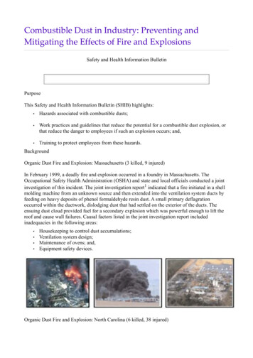
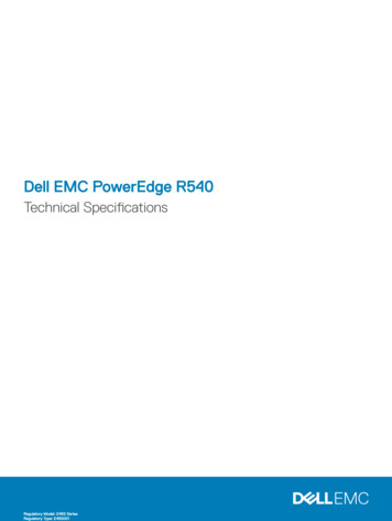
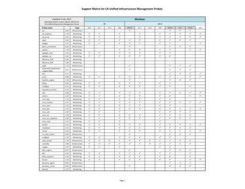
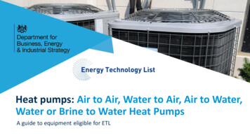
Air Quality and Dust Monitoring Summary Report, May 2022London Borough of HillingdonMonthly Summary1.1.1This Summary Report is published in fulfilment of commitments detailed in the HighSpeed Rail (London-West Midlands) Environmental Minimum Requirements, Annex 1:Code of Construction Practice, for the nominated undertaker to present the results of airquality and dust monitoring undertaken in the London Borough of Hillingdon (LBH)during April 2022 and May 2022 respectively.1.1.2Figure 1 to Figure 4 in Appendix A indicate the current worksites, together with air qualitymonitoring locations.1.1.3This summary should be read in conjunction with the overview monitoring reportavailable from nvironmentaleffects-of-hs2, which highlights: the applicable standards and guidance, as well as the airquality and dust monitoring methodologies to be implemented by nominatedundertakers throughout construction.1.1.4The current phase of works commenced in July 2017 and is expected to be completed by2025. The current worksites, as presented in Appendix A, Figure 1 to Figure 4, include: Gatemead Embankment, Breakspear Road South and River Pinn Underbridge pilingoperations, groundworks and materials management;Groundworks, piling and materials management, concreting and shuttering works atCopthall North and South;West Ruislip Portal piling and groundworks, concreting and materials management;South Ruislip ground works, piling operations, concrete works and materialsmanagement;Northern Sustainable Placement Area (NSPA) materials movements and groundworks;Southern Sustainable Placement Area (SSPA) site mobilisation and set-up, spoiltreatment area construction.CVV Dews Lane Jetty piling: piling plant, support plant, platform and compound; HOAC Compound: compound operation; Cofferdam Sheet Piling: piling plant and support plant; Permanent Main Piling Works: boring pile, de-sanding pile bore at pile position,installing reinforcement cage and concreting pile, bored pile break-down to preparethe pile surface, grout curtain around viaduct pile groups maintenance plant; INNS-GUC to Harvil Road: removal works; Ground Investigation Works: GI works; Pier Construction: yard supporting activities, post tensioning of AFD legs and towercrane mob / demob; ATFS Duct Installation: site preparation, installation of ducts and earthworks; Pumping Water Management: pumping water management ch 25.900 to 29.500; Maintenance of the Haul Road: maintenance of the haul road ch 25.900 to 29.500;Page 1
Air Quality and Dust Monitoring Summary Report, May 2022London Borough of Hillingdon Satellite Welfares;Generator Farms;North Abutment: completion work at bearing shelf / parapet and yard supportingactivities;South Abutment: earthworks/stabilisation, driven/CFA piling, pile trimming & pile hatinstallation and drainage works;Core Drilling of Concrete;Pile Trimming;Grand Union Canal Work: haul road, pontoon installation and condition survey;Harefield Lake No.2: compensation pond;SCS Material Storage;Fencing Finishing Works;Utility Diversions;Environmental Maintenance;NYGB River Crossing;Cofferdam Excavation;Dewatering at P11;Stockpiling Activity HOAC: stockpile of material coming from other sites;HOAC car park construction: civilisation works in the NGET area;RC Crossing: emergency dismantling of obstruction;Launching Girder and Deck Works: span segmental erection with launching gantry,shoring steel structure erection and dismantling and internal PT stressing & grouting;andUtilities-H3.CVV Moorhall Road Jetty Piling: piling plant, support plant, platform and compound; Cofferdam Sheet Piling: piling plant and support plant; Permanent Main Piling Works: boring pile, desanding pile bore at pile position,installing reinforcement cage and concreting pile, bored pile break-down to preparethe pile surface and grout curtain around viaduct pile groups maintenance plant; South & North Moorhall Road Compound: compound operation and de-sandingcompound; INNS-River Colne to GUC: removal; Ground Investigation Works: GI works; River Colne Realignment; Crossings Tarmac: Moorhall Road Junction; CFA Pile Caps at P22 & P30: CFA piling, FRC to pile caps and earthworks; Pier Construction: arch form deck pier 33 and straight pier P38 – FRC works for pilecap and peir, yard supporting activities, post tensioning of AFD legs and tower cranemob / demob; ATFS Duct Installation: site preparation, installation of ducts and earthworks; Pumping water management from ch 25.900 to 29.500; Maintenance of the haul road from ch 25.900 to 29.500; Satellite welfares;Page 2
Air Quality and Dust Monitoring Summary Report, May 2022London Borough of Hillingdon Generator farms;Core drilling of concrete;Pile Trimming;A412 Gas Crossing: emergency dismantling;Grand Union Canal Work: pontoon installation and condition survey;SCS Material Storage;Fencing Finishing Works;Utility Diversion;Environmental Maintenance;Cofferdam Excavation;RC Crossing: emergency dismantling of obstruction;Launching Girder and Deck Works: span segmental erection with launching gantry,shoring steel structure erection and dismantling and internal PT stressing & grouting;andUtilities.1.1.5Twelve (12) dust monitors are installed around worksites, where works are underway. Thesites returned a low to medium dust risk rating.1.1.6Dust monitoring locations and results are presented in Appendix B, Table 1, together withline charts of monthly data from each dust monitor in Figure 5. All continuous dustmonitoring is undertaken using indicative monitors. Despite being Environment Agency(MCERTS) certified, indicative monitors carry a higher level of uncertainty than referencemonitors, and therefore cannot be strictly compared with Air Quality Standards forhuman health and the environment. The purpose of the monitoring undertaken is toensure the effectiveness of the on-site mitigation.1.1.7The trigger level for PM10 concentrations of 190µg/m3, over a 1-hour period, in accordancewith the updated guidance document ‘Guidance on Monitoring in the Vicinity of Demolitionand Construction Sites – (October 2018)’ has been applied.1.1.8Dust trigger alerts were recorded during the monitoring period (May 2022) and arereported in Appendix B, Table 2.1.1.9Data capture was below 90% for multiple monitors in May 2022 due to power supplyissues which have since been resolved.1.1.10Diffusion tube monitoring of Nitrogen Dioxide (NO2) is undertaken at eleven (11) locationsaround highways within the LBH as part of the management of air quality wheresignificant effects may occur as a result of the scheme.1.1.11Diffusion tube monitoring results are provided from the laboratory analysis, andtherefore still require various analysis and adjustments to be undertaken. Final correctedresults will be presented and described in the annual report. However, based on theresults to date, no unexpected values were recorded during the monitoring period.Page 3
Air Quality and Dust Monitoring Summary Report, May 2022London Borough of Hillingdon1.1.12NO2 monitoring locations and results are presented in Appendix C, Table 3, together withthe 2022 running mean.1.1.13There were no (0) complaints received during this reporting period.Page 4
Air Quality and Dust Monitoring Summary Report, May 2022London Borough of HillingdonAppendix A – Worksites and Monitoring LocationsFigure 1 to Figure 4: Current monitoring locations within the LBHPage 5
MP4!(!(AQ034!(HillingdonLondon BoroAQ033AQ050!(!(South 20BPN")HS2-000020BPK")Legend")!(Diffusion TubeDust MonitorDistrict Borough Unitary BoundariesWorksiteService Layer Credits: Sources: Esri, HERE, Garmin, Intermap, increment P Corp., GEBCO, USGS, FAO,NPS, NRCAN, GeoBase, IGN, Kadaster NL, Ordnance Survey, Esri Japan, METI, Esri China (HongKong), swisstopo, OpenStreetMap contributors, and the GIS User CommunityMap NumberHS2 Ltd accept no responsibility for any circumstances, whicharise from the reproduction of this map after alteration,amendment or abbreviation or if it is issued in part or issuedincomplete in any way.Map NameWorksite and Monitoring LocationsIn LBH (Sheet 1)London Borough of HillingdonRegistered in E ngland. Registration number 06791686.Registered office: 2 Snowhill, Queensway,Birmingham B4 6GA. Crown copyright and database rights 2021.Ordnance Survey Licence Number 100049190.Doc Number:IScale at A3: 1:12,0000120240360480MetresDate: 03/11/21
HS2-000020BNT)"HS2-000020BNV)"HarrowLondon BP8)"Map NumberLegend)"Diffusion TubeDistrict Borough Unitary BoundariesWorksiteService Layer Credits: Sources: Esri, HERE, Garmin, Intermap, increment P Corp., GEBCO, USGS, FAO,NPS, NRCAN, GeoBase, IGN, Kadaster NL, Ordnance Survey, Esri Japan, METI, Esri China (HongKong), (c) OpenStreetMap contributors, and the GIS User CommunityHS2 Ltd accept no responsibility for any circumstances, whicharise from the reproduction of this map after alteration,amendment or abbreviation or if it is issued in part or issuedincomplete in any way.Map NameWorksite and Monitoring LocationsIn LBH (Sheet 2)London Borough of HillingdonRegistered in England. Registration number 06791686.Registered office: 2 Snowhill, Queensway,Birmingham B4 6GA. Crown copyright and database rights 2020.Ordnance Survey Licence Number 100049190.Doc Number:IScale at A3: 1:10,0000100200300400MetresDate: 08/12/20
)"HS2-000020BPL)"HS2-000020BQN)"South BucksDistrictHillingdonLondon ctLegend)"Diffusion TubeDistrict Borough Unitary BoundariesService Layer Credits: Sources: Esri, HERE, Garmin, Intermap, increment P Corp., GEBCO, USGS, FAO,NPS, NRCAN, GeoBase, IGN, Kadaster NL, Ordnance Survey, Esri Japan, METI, Esri China (HongKong), (c) OpenStreetMap contributors, and the GIS User CommunityMap NumberHS2 Ltd accept no responsibility for any circumstances, whicharise from the reproduction of this map after alteration,amendment or abbreviation or if it is issued in part or issuedincomplete in any way.Map NameMonitoring Locations In LBH (Sheet3)London Borough of HillingdonRegistered in England. Registration number 06791686.Registered office: 2 Snowhill, Queensway,Birmingham B4 6GA. Crown copyright and database rights 2020.Ordnance Survey Licence Number 100049190.Doc Number:IScale at A3: 1:10,0000100200300400MetresDate: 08/12/20
HS2-000020BNW)"HillingdonLondon BoroLegend)"Diffusion TubeDistrict Borough Unitary BoundariesService Layer Credits: Sources: Esri, HERE, Garmin, Intermap, increment P Corp., GEBCO, USGS, FAO,NPS, NRCAN, GeoBase, IGN, Kadaster NL, Ordnance Survey, Esri Japan, METI, Esri China (HongKong), (c) OpenStreetMap contributors, and the GIS User CommunityMap NumberHS2 Ltd accept no responsibility for any circumstances, whicharise from the reproduction of this map after alteration,amendment or abbreviation or if it is issued in part or issuedincomplete in any way.Map NameMonitoring Locations In LBH (Sheet4)London Borough of HillingdonRegistered in England. Registration number 06791686.Registered office: 2 Snowhill, Queensway,Birmingham B4 6GA. Crown copyright and database rights 2020.Ordnance Survey Licence Number 100049190.Doc Number:IScale at A3: 1:10,0000100200300400MetresDate: 08/12/20
Air Quality and Dust Monitoring Summary Report, May 2022London Borough of HillingdonAppendix B – Dust Monitoring ResultsTable 1: Dust monitoring locations and May 2022 ResultsDustMonitoringCoordinatesLocationsite ID(X,Y)descriptionriskratingforsiteMonitoringsite activeduringperiodNumber ofChange tosite sinceMean 1-hour um 1-Maximum 1-1- hourhour PM10hour PM10periodsData m3)(µg/m3)trigger levelof 190 µg/m3AQ033507045,187352BreakspearRoad est RuislipGolf CourseMYesN12.82.554.6080.2AQ041507942,187028West 029West 86.8AQ049506531,187865CopthallNorth, 187865CopthallSouthCompoundMYesN13.62.453.2082.6On theeasternboundaryalong southside Page 10
Air Quality and Dust Monitoring Summary Report, May 2022London Borough of HillingdonDustMonitoringCoordinatesLocationsite ID(X,Y)descriptionriskratingforsiteMonitoringsite activeduringperiodNumber ofChange tosite sinceMean 1-hour PM10previousconcentrationperiod(µg/m3)Minimum 1-Maximum 1-1- hourhour PM10hour PM10periodsData m )(µg/m )trigger level3report3of 190 µg/m3RoadCVV-AQMP4505589,187793On thewesternboundary ofHOAC at DewsLaneDGT-AQMP506124,188025At the DogTrust onHarvil Road.MYesY6.91.031.0090504321,188835Korda LakeCompound,along haulroute north 01.085.00100Page 11
Air Quality and Dust Monitoring Summary Report, May 2022London Borough of HillingdonTable 2: Summary of exceedances of trigger level in May 2022Monitoring site IDAQ048AQ048Period exceeding trigger level17/05/202209:00 -10:00; 338.1 µg/m322/05/202201:01 - 02:00; 206.7 µg/m302:01 – 03:00; 328.2 µg/m303:01 – 04:00; 459.2 µg/m304:01 – 05:00; 600.0 µg/m305:01 – 06:00; 2142.8 µg/m306:01 – 07:00; 270.3 µg/m3InvestigationOutcomes / Resolution / Remedialmeasures implementedAt the time of the trigger alert grass strimming was being undertaken inthe area around the monitor to enable the completion of perimeterfencing to be installed. It is considered that this was the cause of thetigger alert. Works in the wider area included machinery and vehiclemovements along the new internal haul road and material movements /placement of spoil. Dust suppression is readily available and was beingdeployed in these areas in the form of a tractor-pulled bowser, driven10,oo0l bowser and dust cannons.Subsequent monitored levels dropped again following the completion ofthe grass strimming in the area.It is considered the elevated level waslimited to the immediate vicinity of thegrass strimming and the monitor and nota wider reflection of levels on or beyondthe site.Monitored dust levels as well as theworks themselves will be constantlychecked to ensure dust suppressioncontinue to be effectively applied.The dust triggers were due to a power loss to the monitor which ispowered by a hydrogen generator. With the loss in power due to thehydrogen cylinders running out of gas the pump and heater slowlystopped operating with subsequent false readings.Power was restored a few days later withthe replenishment of the hydrogen gascylinders.Page 12
Air Quality and Dust Monitoring Summary Report, May 2022London Borough of HillingdonFigure 5: Construction dust 1-hour mean indicative PM10 concentration for dust monitorsAQ033AQ034AQ040AQ041Page 13
Air Quality and Dust Monitoring Summary Report, May 2022London Borough of HillingdonAQ047AQ048AQ049AQ050Page 14
Air Quality and Dust Monitoring Summary Report, May 2022London Borough of HillingdonCVV-AQMP3CVV-AQMP4DGT-AQMPCVV-AQMP6Page 15
Air Quality and Dust Monitoring Summary Report, May 2022London Borough of HillingdonAppendix C – Air Quality Monitoring ResultsTable 3: NO2 monitoring locations around highways, NO2 concentrations and monthly monitoring results with running mean for 2022 (µg/m3)Monitoring SiteLocationCoordinates (X,IDdescriptionY)HS2-000020BNTLamp post onPembroke Road509678, 187214HS2-000020BNUCowley Roadsign post atjunction withHillingdon Road505492, 183926High Street signpost at junctionwith PembrokeRoad509439, 187117Signpost onA4020 UxbridgeRoad at junctionwith Long Lane507365, 182687Lamp post increscent offSwakeleys Road506542, 186037Warren Roadsign post oncorner ofSwakeleys Roadand WarrenRoad506240, 185660Lamp post onB467506767, 55329604146463040333751403728394734433039Note: to aid interpretation and conform with best practice, the monthly measurements in this table are reported rounded to the nearest whole number. The annual mean presented here iscalculated based on laboratory data to 4 significant figures, rounded to a whole number, and therefore may differ slightly to a mean derived from averaging the rounded monthly measurements inthe table.1Page 16
Air Quality and Dust Monitoring Summary Report, May 2022London Borough of HillingdonMonitoring SiteLocationCoordinates (X,IDdescriptionY)HS2-000020BQHLamp post onHigh RoadIckenham508451, 186879HS2-000020BQNLamp post onPark Road506176, 185444HS2-000020BQPSign post onLong Lane507614, 184663HS2-000020BP8Triplicate site atSouth Ruisliproadsideautomaticmonitoringstation510858, 140TubeMissing47533656404650365637454232453338Page 17
CFA Pile Caps at P22 & P30: CFA piling, FRC to pile caps and earthworks; Pier Construction: arch form deck pier 33 and straight pier P38 - FRC works for pile cap and peir, yard supporting activities, post tensioning of AFD legs and tower crane mob / demob;