Transcription
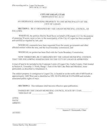
After recording mail to: Logan City Recorder290 N 100 W, UT 84321CITY OF LOGAN, UTAHORDINANCE NO. 22-12AN ORDINANCE ANNEXING PROPERTY TO THE MUNICIPALITY OF THECITY OF LOGANSECTION 1: BE IT ORDAINED BY THE LOGAN MUNICIPAL COUNCIL, ASFOLLOWS:WHEREAS, the petition filed by Reed Scow on behalf of Rivergate LLC for the purposeof annexing 30 acres, more or less, to the municipality of the City of Logan has been acceptedand certified as required by law; andWHEREAS, comments have been requested from the county government and otheraffected entities within the area, and the local boundary commission; andWHEREAS, no protest has been filed with the Cache Boundary Commission;NOW THEREFORE, BE IT ORDAINED BY THE LOGAN MUNICIPAL COUNCILTHAT THE FOLLOWING ANNEXATION TO THE CITY OF LOGAN IS APPROVEDA tract ofland to be included in the Corporate Limits of Logan City, Cache County, Utah locatedin Section 6, Township 11 North, Range 1 East of the Salt Lake Base and Meridian, moreparticularly as described in Attachment A.The subject prope1ty is contiguous to Logan City, is located at on the north side of 600 South atapproximately 1600 West and is identified as TIN: 02-076-0002 & 02-076-0008 and includesassociated public rights of ways.SECTION 2: This ordinance shall become effective upon publication.PASSED BY THE LOGAN MUNICIPAL COUNCIL, STATE OF UTAH,THIS DAY OF, 2022.AYES:NAYS:ABSENT:Jeannie F. Simmonds, ChairATTEST:Teresa Harris, City Recorder
PRESENTATION TO MAYORThe foregoing ordinance was presented by the Logan Municipal Council to the Mayor forapproval or disapproval on the day of, 2022.Jeannie F. Simmonds, ChairMAYOR'S APPROVAL OR DISAPPROVALThe foregoing ordinance is hereby this- - - - - -, 2022.day ofHolly H. Daines, Mayor
Attachment AA tract of land located in Section 6, Township 11 North, Range 1 East of the Salt Lake Base andMeridian, described as follows:Parcel Number 02-076-002THE WEST HALF OF LOT 1, BLOCK 14, PLAT "A", LOGAN FARM SURVEY, LESS ANDEXCEPTING THE FOLLOWING: BEGINNING AT THE NORTHEAST CORNER OF THEWEST HALF OF LOT 1, BLOCK 14, PLAT "A", LOGAN FARM SURVEY, RUNNINGTHENCE WEST 4 FEET, THENCE SOUTH 4 FEET, THENCE EAST 4 FEET, THENCENORTH 4 FEET TO THE POINT OF BEGINNING.Parcel Number 02-076-0008ALL LOT 2, BLOCK 14, PLATE, LOGAN FARM SURVEY, PART OF THE EAST HALFOF SECTION 6, TOWNSHIP 11 NORTH, RANGE 1 EAST.
L@GANl" IIYuNIT[D1NSERV ICEMEMORANDUM TO MUNICIPAL COUNCILDATE:May 17, 2022FROM :Mike DeSimone, DirectorSUBJECT:Ordinance 22-12: Rivergate Annexation RequestBackgroundReed Scow, on behalf of Rivergate LLC , is requesting the annexation of approximately 30 acres, more orless, into the City of Logan. The property is comprised of two separate tax parcels and is located on thenorth side of 600 South at approximately 1600 West. The annexation plat will also include the adjoiningright of ways (600 South & 1900 West) to the centerline. The property is currently used forfarming/ranching activities.The Future Land Use Plan Map identifies the site as Detached Residential (DR). The proposed zoning isNeighborhood Residential (NR-6) which is consistent with the Detached Residential FLUP designationand the adjacent development pattern directly south .The City Recorder certified the Annexation Petition on April 5, 2022. We publicly noticed this annexationrequest and notified affected governmental entities, including both school districts, as required by StateLaw. The County Recorder also publicly noticed this annexation request. Any comments received areattached .If you have questions about this matter, please let me know.AttachmentsOrdinance No. 22-12Proposed Annexation Plat Information
CITY OF LOGAN, UTAHANNEXATION CERTIFICATIONTO:Logan Municipal CouncilRE:Rivergate LLC (owner) and Reed Scow (applicant).Property located on the north side of 600 South at approximately 1600 West, Logan, Utah84321 and consisting of two parcels (02-076-0002 & 02-076-0008) containing approximately30 acres.I, Teresa Harris, Recorder of the City of Logan, Utah, do hereby accept and certify that thePetition for Annexation filed in my office on 3/10/22 for the following parcels meets therequirements of UCA I0-2-403 .Parcel Number 02-076-002Legal: THE WEST HALF OF LOT 1, BLOCK 14, PLAT"A", LOGAN FARM SURVEY, LESSAND EXCEPTING THE FOLLOWING: BEGINNING AT THE NORTHEAST CORNER OFTHE WEST HALF OF LOT I, BLOCK 14, PLAT "A", LOGAN FARM SURVEY, RUNNINGTHENCE WEST 4 FEET, THENCE SOUTH 4 FEET, THENCE EAST 4 FEET, THENCENORTH 4 FEET TO THE POINT OF BEGINNING.Parcel Number 02-076-0008Legal : ALL LOT 2, BLOCK 14, PLATE, LOGAN FARM SURVEY, PART OF THE EASTHALF OF SECTION 6, TOWNSHIP 11 NORTH, RANGE I EASTThe designated contact sponsor:Reed Scow50 E 2500 N STE IO INorth Logan, UT 84341This Certification was provided to the Logan Municipal Council on theA:,!hAl , 2022, with a copy mailed, postage prepaid on A,n,v:.t."Cache County Council199 North MainLogan, UT 84321Reed Scow50 E 2500 N STE 10 INo1th Logan, UT 84341DATEDthis dayofA 1,2022.5day of( ) , 2022. to:
PUBLIC NOTICENOTICE OF PUBLIC HEARINGFOR PURPOSES OF ANNEXING REAL PROPERTY INTO THE CITY OF LOGANThe Municipal Council of the City of Logan has accepted the petition of Reed Scow, on behalf ofRivergate LLC, for the purposes of annexing 30 acres, more or less, into the City of Logan.The Recorder of the City of Logan ce1tified to the Municipal Council on April 5, 2022 that the petitionedannexation meets the statutory requirements of Utah Code Ann. § I 0-2-403.The subject property is contiguous to Logan City, is located at on the 1101th side of 600 South atapproximately 1600 West and is identified as TIN: 02-076-0002 & 02-076-0008. The area of annexationis described as follows:A tract of land to be included in the Corporate Limits of Logan City, Cache County, Utah located inSection 6, Township 11 North, Range I East of the Salt Lake Base and Meridian, described as follows:Parcel Number 02-076-002Legal: THE WEST HALF OF LOT 1, BLOCK 14, PLAT "A", LOGAN FARM SURVEY, LESS ANDEXCEPTING THE FOLLOWING: BEGINNING AT THE NORTHEAST CORNER OF THE WESTHALF OF LOT 1, BLOCK 14, PLAT "A", LOGAN FARM SURVEY, RUNNING THENCE WEST 4FEET, THENCE SOUTH 4 FEET, THENCE EAST 4 FEET, THENCE NORTH 4 FEET TO THEPOINT OF BEGINNING.Parcel Number 02-076-0008Legal: ALL LOT 2, BLOCK 14, PLATE, LOGAN FARM SURVEY, PART OF THE EAST HALF OFSECTION 6, TOWNSHIP 11 NORTH, RANGE 1 EASTThe complete annexation petition and suppotting documentation is available for inspection and copyingin the offices ofthe City Recorder, City of Logan 290 North JOO West Logan, Utah 84321 and in theDepartment of Community Development at the same address during regular City business hours. Moreinformation is available by contacting Mike DeSimone, Director of Community Development, at 435716-9022 or mike.desimone@loganutah.org.The Municipal Council of the City of Logan may approve the annexation following a public hearing onTuesday, May 17, 2022 beginning at 5:30 p.m . in the Municipal Council Chambers at the Logan CityHall, 290 North 100 West, Logan. This public hearing will take place and action may be taken unless aprotest is filed with the Cache County Boundary Commission. A protest to the proposed annexation maybe filed by the legislative body or governing board of an affected entity or the owner of rural real prope1tyas defined in Utah Code Ann. § 17B-2a-l l 07 .The written protest must be filed with the Cache County Boundary Commission, 199 No1th Main, Logan,Utah 84321, no later than 4:00 p.m. on May 5, 2022 and a copy of the protest delivered to the Logan CityRecorder, 290 North I 00 West, Logan, Utah 84321. Failure to meet any and all of the requirementsspecified in Utah Code shall invalidate the protest.Teresa Harris, Logan City RecorderPublication Dates: April 12, April 19, and April 26, 2022
Rive1 ate Anl1.exation-1.900West 600 Southl\larch2022
RiveI-gate Anl1exation-1.900 '\oVest 600South., I!. - :---'--------.--. UBr -DR-DXIIDRDR-DXIII-··-·-·-DRIICurrent C.i tyBoundaryRCAL:ineDRProposed Annexation AreaDRApprox. 30 acresCurrent FLUPDRJ lan:h 2022
Rive1-gate Anl1exation-1.900West 600 SouthNR-4NR-4Current CityBoundaryLinePUBrrent ZoniMan:h2022
Rivergate An11exation-1900West 600 SouthNR-4Current CityBoundaryLineNR-6Pro,posed Annexation Area - 30 acresProposed Zoning NR-6NR-4NR-6PUBNR-6Proposed ZoMarch2022
NOTICEOF INTENT TO FILE A PETITION FORANNEXATION INTO THE CITY OF LOGANPursuant to U.C.A §10-2-403 , I, petitioner, on behalf ofRivergate LLC, do herebyinform you of the intent to submit to the City of Logan a formal petition for annexation ofproperty located on the n01th side of 600 South at approximately 1600 West, consistingof approximately 30 acres and identified as TIN: 02-076-0002 and 02-076-0008. Thisnotice is being sent to you because you are considered an "affected entity" as defined inU.C.A. §10-2-40l(a),Reed Scow50 E 2500 N STE 101No1th Logan, UT 84341This Notice is being sent to:Logan City RecorderCache County RecorderCache County ClerkCache County AssessorCache County Development ServicesCache County Bounda1y CommissionLogan City School DistrictCache County School DistrictCache County Fire DistrictCache Valley Transit DistrictCache Mosquito Abatement District
Riverg ateAnnexation Plan: LiGANan4tll llfi . IU l t Y l"Notice: There will be no public election on the annexation proposed by this petitionbecause Utah law does not provide for an annexation to be approved by voters at apublic election.I you sign this petition and later decide that you do not support the petition, you maywithdraw your signature by submitting a signed, written withdrawal with the recorder orclerk of Logan City. If you choose to withdraw your signature, you shall do so no laterthan 30 days after the City of Logan receives notice that the petition has been certified."APPLICATION FOR ANNEXATION REVIEW- :w-tDate of Applicationl/l3/2022Total Acreage Involved .3 0 ------------Approx 1900 W. 600 S·- ----------------------------Address of Proposed AnnexationCurrent and Proposed Future Use of the Land (Future Zoning)Current A-10, Proposed NR-6Include the following additional information with this application:1. Plat Map(s) showif'l1 all of the land Included in the proposed annexation2. A copy of the current year Cache County Tax Roll Report for each propertyPlease ensure the following table Is complete. Indicate the official sponsor of the anneKatlon by circling thename. Attach additional 1 81,es if necess w.Name clProP8rtv O'MlerPrintedRIVERGATE LLC1.Date1/13/2022Tax ID#02-076-0002Property AddressApprox 1600 WSOOSAssessedValuation 600,000Approx 1o Acres50 E 2500 N STE 101NORTH LOGAN, UT 84341435-994-5702Printed Name ofPronertv Owner2. Rivergate LLCDate1/13/2022-71 r'/2 //Property SizeMailina Address and Phone Number of Contact PersonReedScat1Signature or Property Ownerin Favor of AnnexationTax ID#02-076-0008Property AddressApprox 1900 W600 SAssessedValuation 300,000Signature of Property Ownerin Favor of Anne tion./'2, 1 ,,,.,i/-,, --Propenv SizeMailing Address and Phone Number of Contact PersonReedScaN50 E 2500 N STE 101NORTH LOGAN, UT 84341435-994-5702Printed Name ofPronertv OwnerDateApprox 20 AcresTax ID#Property AddressAssessedValuationSignature r:I Property Ownerin Favor of Annexation3.Mailing Address and Phone Number of Contact PersonProperty Size
Riverg ateAnnexation PlanVicinity MapThe Rivergate Master-Planned Community is located south west of Downtown Logan, along600 S (Mendon Rd.)and just west of 1000 W. The eastern property falls under the SuburbanNeighborhood Residential (NR-4) Zone.STATE ROADCOLLECTORPROJECT BOUNDARYPROPOSEDANNEXATION LAND'IIF TIHs II nc1ge, on l h1, pug0 represm1! un u1 !isl' s renrlr·1 ing. orP cone epluol 111 1,cilu11;, rJm I ,uL,1 ·c I k, c hr111q, ·1
RivergateAnnexation PlanLegal DescriptionEnt 1306350 Bk 2305 Pg 0662PARCEL 1: (02-066-0021)THE WEST HALF OF LOT 1, BLOCK 15, PLAT "A", LOGAN FARM SURVEY AND BEINGSITUATE IN SECTION 5, TOWNSHIP 11 NORTH, RANGE 1 EAST OF THE SALT LAKEBASE AND MERIDIAN.SITUATE IN CACHE COUNTY, STATE OF UTAH.PARCEL 2: (02-066-0033)BEGINNING 12 RODS WEST OF THE SOUTHEAST CORNER OF LOT 1, BLOCK 15, PLAT"A", LOGAN FARM SURVEY, THENCE WEST 28 RODS, THENCE NORTH 20 RODS,THENCE EAST 28 RODS, THENCE SOUTH 20 RODS TO BEGINNING.LESS AND EXCEPTING THE FOLLOWING:A PARCEL OF LAND, IN FEE FOR THE WIDENING OF EXISTING STATE HIGHWAY SR-252KNOWN AS PROJECT NO. S-0252(6)0, BEING PART OF LOT 1, BLOCK 15, PLAT "A",LOGAN FARM SURVEY, A SUBDIVISION SITUATE IN THE NW 1/4 SE 1/4 OF SECTION 5,TOWNSHIP 11 NORTH, RANGE 1 EAST, SALT LAKE BASE AND MERIDIAN, IN CACHECOUNTY, UTAH, THE BOUNDARY OF SAID TRACT IS DESCRIBED AS FOLLOWS:BEGINNING ON THE NORTH RIGHT OF WAY LINE OF THE EXISTING 600 SOUTHSTREET IN LOGAN CITY AT A POINT 28.4 FEET DISTANT NORTHERLY FROM THECONTROL LINE FOR SAID PROJECT AT ENGINEER STATION 6002 72.2, SAID POINTBEING 12 RODS (WEST) NORTH 88 14'57" WEST FROM THE SOUTHEAST CORNER OFSAID LOT 1, AND RUNNING THENCE (WEST) NORTH 88 14'57" WEST A DISTANCE OF76.18 FEET ALONG SAID EXISTING NORTH RIGHT OF WAY LINE, THENCE NORTH 77 12'04" EAST 78.64 FEET, THENCE (SOUTH) SOUTH 1 34'02" WEST 19.76 FEET TO THEPOINT OF BEGINNING AS SHOWN ON THE OFFICIAL PLANS FOR SAID PROJECT IN THEOFFICE OF THE UTAH DEPARTMENT OF TRANSPORTATION.SITUATE IN CACHE COUNTY, STATE OF UTAH.PARCEL 3: (02-066-0030)BEGINNING 32 RODS WEST OF THE NORTHEAST CORNER OF LOT 1, BLOCK 15, PLAT11 11A 1 LOGAN FARM SURVEY, THENCE WEST 8 RODS, THENCE SOUTH 20 RODS,THENCE EAST 8 RODS, THENCE NORTH 20 RODS TO THE POINT OF BEGINNING.- SITUATE IN CACHE COUNTY, STATE OF UTAH.PARCEL 4: (02-076-0002)THE WEST HALF OF LOT 1, BLOCK 14, PLAT "A", LOGAN FARM SURVEY.LESS AND EXCEPTING THE FOLLOWING:BEGINNING AT THE NORTHEAST CORNER OF THE WEST HALF OF LOT 1, BLOCI 14,PLAT "A", LOGAN FARM SURVEY, RUNNING THENCE WEST 4 FEET, THENCE SOUTH 4FEET, THENCE EAST 4 FEET, THENCE NORTH 4 FEET TO THE POINT OF BEGINNING.SITUATE IN CACHE COUNTY, STATE OF UTAH.PARCEL 5: (02-076-0008)ALL LOT 2, BLOCK 14, PLATE, LOGAN FARM SURVEY, PART OF THE EAST HALF OFSECTION 6, TOWNSHIP 11 NORTH, RANGE 1 EAST.
Riverg ateAnnexation PlanLegal Description ContinuedSITUATE IN CACHE COUNTY, UTAH.PARCEL 6: (02-066-0019)THE WEST HALF LOF LOT 2, BLOCK 15, PLAT "A", LOGAN FARM SURVEY AND BEINGSITUATE IN SECTION 5, TOWNSHIP 11 NORTH, RANGE 1 EAST OF THE SALT LAKEBASE AND MERIDIAN.SITUATE IN CACHE COUNTY, STATE OF UTAH.PARCEL 7: (02 066-0020)THE EAST 10 ACRES OF LOT 2, BLOCK 15, PLAT "A", LOGAN FARM SURVEY AND BEINGSITUATE IN SECTION 5, TOWNSHIP 11 NORTH, RANGE 1 EAST OF THE SALT LAKEBASE AND MERIDIAN.SITUATE IN CACHE COUNTY, STATE OF UTAH.
Riverg ateAnnexation PlanDate 03-Dec- 2021 Ol:S3PM Fee 40.00WHEN RECORDED MAIL TO:Devron Andersen, Rec. - Filed By SZRIVERGATE, LLCCache County, UT60 E. 2500 North #101For INWEST TITLE SERVICES, INC. - LOGElectronically Submitted by SimplifilNorth Logan, UT 84341SPACE ABOVE THIS LINE FOR RECORDERS USE ONLYRECORDED AT THE REQUEST OF INWEST TITLE SERVICES, INC. ORDER# 282272MAIL TAX NOTICE TO: VISIONARY HOMES 2020 LLCCORRECTIVE WARRANTY DEEDBBi LANO, LLCGRANTOR(S)OF LOGAN, COUNTY OF CACHE11 STATE OF UTAHHEREBY CONVEY AND WARRANT TORIVERGATE, LLCGRANTEE(S)OF LOGAN, COUNTY OF CACHE, STATE OF UTAHFOR THE SUM OF TEN DOLLARS AND OTHER GOOD AND VALUABLE CONSIDERATION,THE FOLLOWING DESCRIBED TRACT OF LAND IN CACHE COUNTY, STATE OF UT:{02-066-0021, 02-066-0033,02-066-0030, 02-076-0002, 02-076-0008, 02-066-0019, 02-066-0020 )See Attached Exhibit "A" THIS CORRECTIVE WARRANTY DEED IS BEING RECORDED TO CORRECT THE LEGAL DESCRIPTION TOPARCEL 02-076-0008SUBJECT TO EASEMENTS, RESTRICTIONS, COVENANTS AND RIGHTS OF WAY OF RECORD, AND TAXES FORTHE YEAR 2021 AND THEREAFTER.TOGETHER WITH ANY AND ALL INTEREST PERTAINING TO WATER RIGHT NUMBER 26-3140WITNESS, THE HAND(S) OF SAID GRANTOR(S), THIS 2nd day of July, 2021 .BBi LAND, LLCBY: BAUGH BROTHERS INVESTMENT, LLCACKNOWLEDGMENTSTATE OF UTAH)(ss.COUNTY OF CACHE)On DECEMBER 2, 2021, personally appeared before me KAE LYNN BEECHER, MANAGER, whose identlty(les)ls/are personally known to me, or proven on the basis of satisfactory evidence, and who by me duly sworn/affirmed, didsay that he/she/they ls/are acting In the capacity referenced above for BAUGH BROTHERS INVESTMENT, LLC,MEMBER OF BBi LAND, LLC and that said document was signed by him/her/them In behalf of said Limited LiabilityCompany by the authority of Its Articles of Organization, Operating Agreement, or by consent of the Company Members,and said lndlvldual(s) acknowledged to me that said Limited Llablllt Company executed the same. NV ' -.'.JC Ot AR -".IQ\ 717008MVOOMM188ION E)(PIAESMARCH 1&, 2028STATE OF UTAHMy Commission Expires: MARCH 15, 2025Residing at: CACHE COUNTY
bCache County Trnasurer's OfficeCraig McAllister Treasurer179 N MAIN ST· ROOM 201Logan, Utah 84321-5126(435) 755-1500(877) 690-3729 Phone PaymentsUSE JURISDICTION CODE: 3412Jl'e:t\PJty1857www.c:ad1oco11n ly.org/tron .11rorWebsite Is up lntod nightly to rellecl 1 11yments.Additional answers an l resources nre avallablo onllne.2021 TAX NOTICE ,.:DUE N VEMBER 30 , 2021Parcel Number: 02-076-0002OlcoN(")N,OlNllill lllll lllll lllll lllll1111111 Hiil111111111111111111TAX DISTRICT: 1280""".N15565"'G51" 140.08"1153/11G4"'""''SNGLP0RIVERGATE LLC,50 E 2500 N STE 101NORTH LOGAN UT 84341-309000!?JNoticesOnline.com :!0.cou-it'0CCU-HY96Q3NT§, )Go Ps erle ss,N0See back of tax statement and lnsel'tfor more Information about eNotlcosl* Stay Healthy«· Stay Safe ** You Can Pay Your TAXES frorn HOME ** View Current & Previous TAXES and Much More *Properly Address:TAXES HEREIN ENUMERATED FOR THE CURRENT YEAR ARE DUE AND PAYABLE TO TREASURER'S OFFICE, LAST NOTICE REQUIRED BY LAW.LEGAL DESCRIPTION (MAY BE INCOMPLETE)BEING W/2 OF LOT 1 BU 14 PLAT ALOGAN FARM NE/4 SEC 6 T 11N R 1E10AC 4210PROPERTY TYPEMARl ET VALUE10.00I'" PLEASE NOTE NEW PAYMENT OPTIONS '"ENTITY283033363848686067ACRES/COUNTLAND GREENBELT300,000.0010.00TOTALS300,000.00TAXING UNITCACHE CO GENERAL FUNDCACHE SCHOOL DISTRICTCOLLEGE/YOUNG MOSQ ABATECACHE WATER DISTRICTCACHE CO HEALTH FUNDMUL Tl-CO A & CCACHECOA&CCACHE SCHOOL STATE LEVYCACHE SCHOOL CHARTER LEVTAX RATEIR,'J .r50iteTAXABLE VALUETAX AMOUNT3,760.0033.323,760.0033.32TAX AMOUNT· BREAl 51.086.250.190.008862)REPAYMENTSNTS TO TAXES2021 TAX DUE33.320.000.0033.32TOT/\L DUE33 .32LLC.Plonso soo rovorso sldo of lhls noticelowWHERE DO YOUR TAXCAN YOU PAY YOUR TAXES? ··-,· . .--, , --· ,J: Samo foos arc chorgoll In person, onllno or l y phone,. .;:,, E·Chocl : Pay onllno at M: X(S ;!\e IY.Qtaitc.Uill!l!l or elioliw.Ontiru, .!.'1.!ll, cl CACII YIMER DIS!RICT (0 :tl' I. . -,c · · . ·· · ·· (ACII E CO Qf.UEIIAI. f UUO (10 Oll"f.t)You will receive a pald-ln-lul email recerpt. Tliilnk you rorush19 llifs safe andsecure method. There are NO ADDITIONAL FEES ror E-Chcck.Mall: Use the enclosed envelope and payment coupon. Write your ,iarcelnumber on lhe check. l'nyrnonl must be postmarl1od by Novombor 30, 2021 Keep the top of lhls notice for your receipt ., . CA.CHECO . EAt.TU fUUO \0 O) N , I- COU.EOE VOUNQ t.10SO AB 1 ,IGJ )CACHE COAA C: ,, so ,C/\CHE 6Cl100lCMM1 n (0 0n tCredit Cnrd & Doblt Cord: Poy online at \'il'.ll! J. Wa.vJ11Y,QJ.llilila\:t111 orqtJ2.ti uOjlliu\UQffi. Thlrd-pa1ly fees will bo odded. You will receweapa[d-rn-fulleman roce pt.Phono: Please call (877) 690.3729, and use Cache County Jurisdiction Code: 3412C.CHC SCIIOOL 0 1 TA :GT (Sl.lW ICACHESCHOOl SfA1 lE(ll 14l )Bonk BIii Pay: Payment may be sent through your bank bill pay. Pnrmontmust bo dollvorod by Novcmbor 30, 2021. (Allow 6 days for poymont.iPloaseloldonpor1oratlonBEFOREtoarfnuOur Offico· You can pay at 179 North Main, second lloor, Room 201 .l\l'POIN1 ,., Nm MAY OE Hl!QUIRtD. There 810 also two drop boxes forv.our convonicnco: 1) localed Just oulsldo the Troasuror's Otnco and 2)Adrlvo,upif cop box Is avollable in the west parkln9. lot. Par.menls with an email listed on lheenvelope will receive a paid-In-lull ernarl rccelp .DIJE TO ,URRt;NT CIRCUMSTANCES1: /\RLY PAYMENT IS IIIGI-ILY HECOMM NDEDPLEASE BRING THE ENTIRE UN SEPARATED NOTICE Wl EN PAYING IN PERSON 'IF MAILING IN PAYMENT, DETACH AND l EEP ABOVE PORTION FOR YOUR RECORDS.
3/8/22, 2:02 PMCORE - Parcel #02-076-0002 In 2021Parcel #02-076-0002 in 2021 - Cache County COREOwner(s)[ History }0RIVERGATE LLC (09/09/2021 - Present)(Vesting: 1291949)Owner(s) [ History JRIVERGATE LLC, (09/09/2021 - Present)(Vesting : 1291949)Property AddressCurrent Owner Mailing Address50 E 2500 N STE 101NORTH LOGAN, UT 84341-30900 Tax District: COLLEGEYOUNG MOSQUITO ABATEMENT DIST (128)0 Tax Status: Taxable0 Parcel History: SUBJ TO BLA W/ 00070 Legal Description: BEING W/2 OF LOT0 Acres: 10O Water Rights: Yes , bydocument (s) : 111291949 1112919512/211 BLK 14 PLAT A LOGAN FARM NE/ 4 SEC 6 T llN R lE 10 AC 4210Taxation TermAmountPrior Year Taxes (2020) 34 . 800 Market Value 300,000.00Greenbelt Land 300,000.000 Taxable Value 3 , 760.000Tax RateXOTaxAmount 33.320 Last Payment Date11/29/2021Payment CategoryAmount0 Principal 33 . 320 Payments 33 . 320 Current Amount Due 0 . 000 . 008861999999999998The boundaries of this parcel changed on 02/08/2021. As such, this Is purely historical data. Any future transactions wlll be displayed ondescendent parcels. DO NOT use this amount as a payoff amount. View the AbstractIC 2022 · CORE (03/08/22 03:17 AM)HelpI About I 2-076-0002/2021?print y&chart n&hlslory n(objecl HTMLlnpulElemenl)1/1
3/8/22, 2:01 PMCORE · Parcel #02-076-0008 In 2021Parcel #02-076-0008 in 2021 - Cache County COREOwner(s)0[ History JRIVERGATE LLC (12/06/2021 - Present)(Vesting: 1306350)Owner(s) [ History }Property AddressCurrent Owner Mailing Address50 E 2500 N STE 101NORTH LOGAN, UT 84341-30900Tax District: COLLEGE YOUNG MOSQUITO ABATEMENT DIST (128)00Tax Status: TaxableOWaterRights: Yes, by document(s): 111291949 !112919510Legal Description: ALL LOT 2 BLK 14 PLAT E LOGAN FARM SV'l E/2 SEC 6 T llN R lE 20 AC D4211Acres: 20!11306350AmountTaxation TermPrior Year Taxes (2020)00 64 . 93- - - - - - - - - - · --- --·-Market Value 600,000.00Greenbelt Land 600,000.00Taxable Value 7,015.000Tax Ratex 0,008861999999999998OTaxAmount 62.17012/08/2021Last Payment DatePayment CategoryAmount0Principal 62.170Penalty 10 . 000Payments 72 . 170Current Amount Due 0 . 00 2022 CORE (03/08/22 03:17 AM)HelpIAboutI 2-076-0008/2021?prinl y&chart n&hlslory y[object HTMLlnputElement)1/1
3/8/22, 2:03 PMCORE - Recorded Document #1275696Ent 1275696 Bk 2224 Pg 1031Date 08-Feb-2021 03:0SPH Fee 40.00Devron Andersen, Rec. - Filed By SACache County, UTFor AMERICAN SECURE TITLE LOGANElectronically Submitted by Simplifile168445WHEN RECORDED MAIL DOCUMENTAND TAX NOTICE TO: \\ .k KCll'ICl ltnwwo 'w .1n0 ;. rn rrn fHtl a, l,A;f tth /i/JiJQUIT CLAIM DEED FOR BOUNDARY ADJUSTMENTBBi LAND, LLCGrantor,of LOGAN, County of CACHE, State of UTAHhereby QUIT CLAIM toGAIL 0. RYAN AND KARLA RYAN, HUSBAND AND WIFE,Grantee,of LOGAN, County of CACHE. State of UTAH, for the sum of TEN DOLLARS and other good and valuableconsideration, the following tract of land In CACHE county, Slate of UT, to-witNEW LEGAL FOR 02-076-0007THE W/2 LOT 8 BLK 14 PLATE LOGAN FARM SVY. ALSO: BEG SE: COR LT 7 SD BLK & TH N 18 FTTH W 700 FT TH S 18 FT TH E 700 FT TO BEG ALL LINES PARALLEL TO LT LINES. ALSO: BEG N0 10 47 W 18.0 FT ALG W LN OF 1600 W ST OF SECOR LT 7 SD BLK 14 & TH W 700.0 FT TH S 18.0FT TO S LN LT 7 TH W 40.0 FT TH N 60.0 FT THE 739.9 FT TOW LN OF 1500 W ST TH S 0 10147" E32.0 FT TO BEGALSO: Beginning at the Northeast comer of the West hall of Lot 1 Block 14 Plat A LOGAN FARM SURVEY,running thence West 4 feet, thence South 4 feet, thence East 4 feet, thence North 4 feet to the point ofbeginning.NEW LEGAL FOR 02-076-0002The West half of Lot 1, Block 14, Plat A, LOGAN FARM SURVEY.LESS: Beginning at the Northeast corner of the West half of Lot 1 Block 14 Plat A LOGAN FARM SURVEY,running thence West 4 foe!, thence South 4 feet, thence East 4 feet, thence North 4 feet to the point ofbeginning,THIS DEED IS BEING RECORDED TO ADJUST THE BOUNDARY LINES OF PARCELS 02-076-0007 AND02-076-0002Subject lo easemonts, restrictions and rights of way appearing of record and enforceable In law and subjectlo 2021 taxes and thereafter.WITNESS the hand of said grantor, thisK day of February, 2021BB ND, CBY: 'Y(I/J (71,ANL,.,KAI: LYNN EECHER,ana 12756961/2
3/8/22, 2:03 PMCORE - Recorded Document #1275696Ent 1275696 Bk 2224 Pg 1032STATE OF UTAH )§COUNTY OF CACHE-1On theday of February, 2021, personally appoared before me KAE LYNN BEECI-IER, who being dulysworn, did say that he/she Is the MANGER of BBi LAND, LLC, by authority of Its Articles of Organizationand duly acknowledged to me that the said Limited Llabllity C mpany executed the same./,n.Noter Public (?fiMy ommlss10 Expires: / /of V'lResl Ing at:(JrUJ t\ NOTARY l'llHI.ICl IM R, WINWARDMy Comm1s,1on # 713469My Commlulon ExpiresAuguet 19, 2024- - - - - S 1 i \ T l i OF l /1275696212
·; p !f JJJJJJ 1 1 i l "3 f" 1 f r I ,: f HH'I ju h·l·P gt,iHer. fIi · ·aI!!,1H 9Ii!i'.1·; ,1J l! ii J!!J§i \i-i la!I :if ,l l'!(iplf!u h ;!; · 8.· PJiije j !i ! ,Jiill u u; !!jlhlhHJhsi Hh.H.h,II\1h0 1r§'iiI I \\, ,sI iI -,/,. .,,'lht11---- ---ii.lUMq:oo,n 8I ; 5I 1,11.''QQ ! a!//S?i,.;; g ii 'rflij:;r; e· !II ! n ; § ih8&I' · '·'I·i1 \ \\ ii --- --r--i ',,,,'/II. 11a -, iI.\: h j'lj Y}!11z ]! I;'I.Ii, l i, n1 I ! tli'@· .,a! i I -Id 'r i hl I II!· ;1 i?1h! hhi§ 1 J1jp1 1!e·E @ u1-·· J 11tle JJ-J' t'r] llj!,i g :if isl,! ! l ,. ;;i1a:Ilgi! II'1!I! I, I9 I I i "
Rivergate AI111exatio11-1900 West 600l\lan:b 2022South
PUBLIC NOTICENOTICE OF PUBLIC HEARINGFOR PURPOSES OF ANNEXING REAL PROPERTY INTO THE CITY OF LOGANThe Municipal Council of the City of Logan has accepted the petition of Reed Scow, on behalf ofRivergate LLC, for the purposes of annexing 30 acres, more or less, into the City of Logan.The Recorder of the City of Logan certified to the Municipal Council on April 5, 2022 that the petitionedannexation meets the statutory requirements of Utah Code Ann. §10-2-403.The subject property is contiguous to Logan City, is located at on the north side of 600 South atapproximately 1600 West and is identified as TIN: 02-076-0002 & 02-076-0008. The area of annexationis described as follows:A tract of land to be included in the Corporate Limits of Logan City, Cache County, Utah located inSection 6, Township 11 North, Range 1 East of the Salt Lake Base and Meridian, described as follows:Parcel Number 02-076-002Legal: THE WEST HALF OF LOT 1, BLOCK 14, PLAT "A", LOGAN FARM SURVEY, LESS ANDEXCEPTING THE FOLLOWING: BEGINNING AT THE NORTHEAST CORNER OF THE WESTHALF OF LOT 1, BLOCK 14, PLAT "A", LOGAN FARM SURVEY, RUNNING THENCE WEST 4FEET, THENCE SOUTH 4 FEET, THENCE EAST 4 FEET, THENCE NORTH 4 FEET TO THEPOINT OF BEGINNING.Parcel Number 02-076-0008Legal: ALL LOT 2, BLOCK 14, PLATE, LOGAN FARM SURVEY, PART OF THE EAST HALF OFSECTION 6, TOWNSHIP 11 NORTH, RANGE 1 EASTThe complete annexation petition and supporting documentation is available for inspection and copyingin the offices of the City Recorder, City of Logan 290 North 100 West Logan, Utah 84321 and in theDepartment of Community Development at the same address during regular City business hours. Moreinformation is available by contacting Mike DeSimone, Director of Community Development, at 435716-9022 or mike.desimone@loganutah.org.The Municipal Council of the City of Logan may approve the annexation following a public hearing onTuesday, May 17, 2022 beginning at 5:30 p.m. in the Municipal Council Chambers at the Logan CityHall, 290 North 100 West, Logan. This public hearing will take place and action may be taken unless aprotest is filed with the Cache County Boundary Commission. A protest to the proposed annexation maybe filed by the legislative body or governing board of an affected entity or the owner of rural real propertyas defined in Utah Code Ann. §17B-2a-1107.The written protest must be filed with the Cache County Boundary Commission, 199 North Main, Logan,Utah 84321, no later than 4:00 p.m. on May 5, 2022 and a copy of the protest delivered to the Logan CityRecorder, 290 North 100 West, Logan, Utah 84321. Failure to meet any and all of the requirementsspecified in Utah Code shall invalidate the protest.Teresa Harris, Logan City RecorderPublication Dates: April 12, April 19, and April 26, 2022
Rivergate Aln1exatio11-1900 West 600l'tlan:b2022South
CITY OF LOGAN, UTAH ANNEXATION CERTIFICATION TO: Logan Municipal Council RE: Rivergate LLC (owner) and Reed Scow (applicant). Property located on the north side of 600 South at approximately 1600 West, Logan, Utah 84321 and consisting of two parcels (02-076-0002 & 02-076-0008) containing approximately 30 acres.
