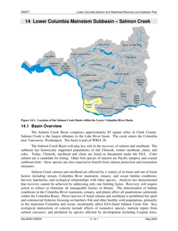
Transcription
COUNTY COMMISSIONERSJudy WilsonDistrict OneDiane OberquellDistrict T \VOKevin J. O'SullivanDistrict Thret:THURSTON COUNTYDEPARTMENT OF WATER AND vVASTE i'v1ANAGE"0.JENTRichard D. Blinn, P.E.DirectorNOTICE OF ADOPTIONRevised Interim Stormwater Design Standards for New Development in Salmon Creek BasinFROM:Richard Blinn,Thurston County Dramage Manual AdministratorDATE:October 30, 2000Section 1. SUMMARYEffective immediately, revised interim stormwater standards for new development areimposed for the Salmon Creek Basin (the Basin). These standards replace interim standardsimposed on the Basin pursuant to the Administrator's action dated February 9, 2000. Theseinterim standards will remain in effect until further notice pending conclusion of the County'sconsultant work evaluating the extent and possible mitigations to groundwater floodingthroughout the %aVLQ The completion date for this work is expected sometime during the fallof2002. Basin boundary maps maintained by the Thurston County Storm and Surface WaterUtility describe the boundaries for the Basin. Interim storm water design minimum standardsfor new development in the Basin is presented below under Section 3.Section 2. BACKGROUNDIn response to recurrent groundwater flooding within the Basin, the Thurston County Board ofCounty Commissioners (BoCC) expanded the existing Storm and Surface Water Utility RateBoundary in August 1999. During late summer 1999, the BoCC imposed a moratorium onnew development in groundwater flooding areas. During early fall 1999, staff prepared awork plan and solicited for consultant support. During October 1999, a contract was signedwith URS Greiner Woodward Clyde to produce a calibrated ground and surface water modelfor the Basin. Foil owing the successful delivery of these models. specific alternatives will beevaluated to determine long-terIIJ flood alleviation strategies for the Basin.Responding to concerns from county residents. the BoCC voted to approve Critical AreaOrdinance amendments addressing groundwater-flooding areas on February 7, 2000(Ordinance# 12155). These amendments provide additional requirements for newdevelopment in areas identified on the ·'Resource Map'' for groundwater flooding asmaintained by Thurston County Development Services Department. On February 7, 2000, theBo CC took action extendino0 the building moratorium for. four months for the Basin(Ordinance# 12156); this moratorium has since been lifted.0.lanwJ1::n1cnr, Scnrn1 & Surface \V':.uer }.lnna!,!cmcnr. \V'atcr &. Si:wer Uri!iries Oi:'er:uiun:;, Urilicy Devdorment & Sredal Services1Building No. -f, Ru1)m IL'O, 92.l Lab.'rk!g-e Drin! S\V, Olrmri:i, \YI.-\ 98502(360) 351·2-J.91F.-\X t360) W I -a TDD (360) 154-2933\V
.Section 3. INTERIM DEVELOPMENT ST Ai'IDARDSAPurpose: The County seeks to limit the adverse potential impact from newdevelopment within the Basin. To this end, the County is providing interimstormwater design standards for new development within the Basin: These standardswill remain in place until such time that the County's consultant completes themodeling and alternative evaluation for flood alleviation strategies for the Basin.Upon review of the consultant's final basin report and recommendations, the interimstandards will be reconsidered for ensuring consistency with the basin report.B. Interim Standards: These interim standards are contained within "Interim SiteDevelopment Standards for New Development in Salmon Creek Basin", URS GreinerWoodward Clyde, October 6, 2000. These standards establish screening criteria forimpact, new groundwater moniioring requirements, alter the manner in which newdevelopments are modeled (hydrologic) and require groundwater-mounding analysiswhere appropriate. This additional guidance does not guarantee that new developmentcan successfully complete the review process prior to the County completing theconsultant modeling work. These interim standards are available upon request.Interested parties should contact 0DUNa Cook, Storm and Surface Water ProgramManager, at 360-754-4681 or visit 92LLakeridge Drive SW, Building 4, Room 100,Olympia, WA 98502.C. Authority: In taking this action, the Thurston County Drainage Manual Administratoris exercising the Administrative Authority of Section 1.2 of the Drainage Design andErosion Control Manual for Thurston Countv Washington, 1994 (the Manual).Development proponents are encouraged to review "Interim Site DevelopmentGuidelines for New Development in Salmon Creek Basin" prior to submitting anydrainage plan for review. The following list is not intended to be all-inclusive butdoes provide some direction on key chapters and sections of the Manual affected bythe interim guidelines:D. Relationship to Manual Standards:New screening criteria are established to determine preliminary impact thresholds fornew development. The County has created a "Depth to Water" (DTW) map for usewithin the Basin. This map provides gross guidance on the probable water tableelevation for Basin properties during extreme recharge events. Providing a minimumvertical separation of six feet from the bottom of proposed drainage facilities ismaintained, design methods as detailed in the 1994 edition of the Manual may be usedfor new development.Providino that the screening criteria suggestthat less than six feet of vertical-separation exists, new monitoring requirements apply. Monitoring shall be for aperiod of one year. Proponents may elect to minimally monitor for a period of fourmonths, two of which must be from the period described by December to March.Providing that this reduced monitoring period is elected by the proponent, the2
monitoring shall continue until final stormwater plan preparation. Prior to finalstormwater plan preparation, the proponent will provide all monitoring data with astatistical correlation to County reference wells. If this final analysis alters previousdeterminations regarding the preliminary stormwater plan, then additional mitigationof the stormwater plan shall be required.Section 3.1.1, Section 3, is amended to include the additional bore analysisrequirementSection 3.1.1, Section 9, is amended to include input and output files from continuoussimulation modeling and water balance analysisSection 4.1.1 is amended to reflect the requirement that any increase in off-sitegroundwater flooding or septic system failures due to recharge be prevented.Maximum release rates are amended to reflect the predeveloped runoffhydrograph asdescribed by the continuous simulation model.Sections 4.1.2 is amended such that sizing is based on the results of the amendedmodeling requirements.Section 4.2 is amended to reflect the sizing as defined by the amended modelingrequirements.Section 4.2.2 is amended to reflect the sizing as defined by the amended modelingrequirements.Section 4.3 is amended to refer to Chapter 8, Section 8.5.3.Chapter 5 is replaced by the continuous simulation-modeling requirement. Existingcondition is as described by aerial photography as captured by the County's 1996flight.Section 8.5.3 is am.ended to require six feet of vertical separation.Unless otherwise amended by "Interim Site Development Guidelines for New Developmentin Salmon Creek Basin", URS Greiner Woodward Clyde, October 6, 2000, all other Manual·provisions apply.Any questions regarding this administrative action, please contact Mark R. Cook, Storm andSurface Water Program Manager, at 360-754-4681.cc:Board of Countv CommissionersLinda Hoffmllii'URS Greiner Woodward ClydeDPA Jeff FancherFred KnotsmanDon KruppMark R. Cooktvf C:rp\interimmem l3
'NALINTERIM SITE DEVELOPMENTSTANDARDS FOR NEWDEVELOPMENT INSALMON CREEK BASINPrepared forThurston CountyDepartment of Water and Waste ManagementStorm and Surface Water ProgramOctober 6. 2000URS1500 Century Square1501 Fourth AvenueSeattle, Washington 98101(206) 343-i9339900045.00.00601.
TABlE OF CONTENTSSection 1Introduction . 1·11.1Section 2Background . 1-1Interim Standards . 2·12.l2.2Screening Evaluation . . 2-1Pert'orrnance Standards . 2-3FiguresFigure laInterim Screening Evaluation Process for Salmon Creek BasinAppendicesAppendix AUse of On-site Piezometers and Reference Wells for Estimation of Winter ·1999Groundwater LevelsAppendix BGroundwater Mounding Analysis Guidelines
SECTIONONE1.1IntroductionBACKGROUNDThe Salmon Creek basin has experienced significant flooding problems during the past severalyears. High groundwater conditions appear to be the primary cause of the recent flooding. InAugust 1999, Thurston County imposed a VL a PRQWK moratorium on new development in thebasin to avoid increasing the flooding problems.Thurston County is now conducting a study of groundwater and surface water conditions in thebasin to (1) evaluate the causes and estimated recurrence frequency of the recent flooding;(2) estimate (using groundwater analysis) the approximate extent of high groundwater conditionsoutside the flooded areas that could flood basements or impair septic system drainfields; and(3) identify and assess alternative measures ro mitigate the existing problem areas and avoidfuture problems.In June 1998;Thurston County began installing a network of monitoring wells and stream gagesto collect the data needed to develop groundwater and surface water models of the basin.Calibrated models should be available in June of2001.As an interim measure to ensure that new development within the basin does not e: acerbate theextent of existing flooding, the County is requiring that new development meet additionaldrainage review criteria, under the authority of Section 1.2 of the Drainage Design and ErosionControl Manual for Thurston County, 1994. The interim standards for new development in the·basin are described below. The interim standards define the procedure that project proponentsmust follow to obtain approval for new development in the Salmon Creek basin.
SECTIONTWOInterim StandardsThe interim standards outlined below are intended co guide new development in the SalmonCreek basin until the basin plan has been completed. The interim standards have two basiccomponents:Screening Evaluation. Because of the past history of groundwater flooding in the SalmonCreek basin, Thurston County has established a basin-specific screening criterion regardingthe vertical separation between the bottom of an infiltration facility and the high (winter1999) groundwater elevation at the site. Statistical analyses indicate that the 1999groundwater elevations are likely the highest that have occurred during the last 50 years.According to the basin-specific screening criterion, the maximum groundwater elevationmust be at least 6 feet below the bottom of any infiltration facility at the site. Each projectproponent must conduct a site-specific evaluation to determine whether their proposeddevelopment would meet this basin-specific screening criterion.Performance Standards. If the site-specific evaluation shows that the proposed project isunlikely to flood or exacerbate existing groundwater flooding problems, the projectproponent may proceed with design. However, t.he design must meet basin-specificperformance standards intended to minimize potential impacts on basin hydrology. Inaddition, continuous simulation modeling will be required to design stormwater facilities forsome projects.The screening evaluation and basin-specific performance standards are described below.2.1SCREENING EVALUATIONThe screening evaluation involves the steps outlined below. Figure la provides an overview ofthe screening process.Step 1 Estimate depth to water under winter 1999 conditions. The project proponent mustestimate the depth to water at their site under winter 1999 conditions, using the Depth-to-Watermap recently prepared by Thurston County.If the Depth-to-Water map indicates more than 6 feet of separation between the 1999groundwater elevation and the bottom of any infiltration facility at the site, the projectproponent may proceed with design and permitting. The project must be designed tocomply with the most current version of the County's Drainage Design and ErosionControl Manual.If the Depth-to-Water map indicates less than 6 feet of separation at the project site,the project proponent can either defer the project until the Salmon Creek Basinengineering analysis and plan have been completed, or perform site-specificgroundwater measurements as described in Step 2.Step 2- Measure groundwater elevations and estimate the winter 1999 groundwaterelevations at the project site. The project proponent must install and monitor piezometers toobtain on-site groundwater elevations at the project site. The project proponent must also obtaingroundwater elevation data for several "reference wells" that are monitored by the County. Theproject proponent must then perform a regression analysis to correlate the on-site water leveldata to the reference well data, and use the resulting regression equation to estimate the winter1999 water levels at the project site. The required procedures for piezometer insta!lation, waterURSl
Interim StandardsSECTIONTWOlevel measurement, reference well data acquisition, regression analysis, and estimation of on-sitewater levels are specified in Use of On-site Wells and Reference Wells to Estimate Winter 1999Groundwater Levels in the Salmon Creek Basin (Appendix Al. The key requirements areoutlined below.Piezometer Installation & Surveying. For sites less than 5 aFUHV three piezometers will berequired, unli;ss the County Drainage Manual Administrator detennin.es that fewerpiezometers will be acceptable. For sites greater than 5 acres. the County Drainage ManualAdministrator w"ill specify the number of piezometers required. Piezometers must beinstalled at or near the topographic low point of the site and at planned locations ofstormwater infiltration facilities. Piezometer locations should also allow for broad coverageof site conditions, including triangulation for groundwater flow direction determinations .The borings must be advanced to contact the uppermost lower-permeability unit (e.g., till). Ifno low-permeability unit is encountered within 50 feet of ground surface, the drilling can beterminated and a piezometer instulled. Piezometer screen lengths shall be 20 feet and screensshall extend downward from the highest anticipated water table depth unless geologic fieldconditions indicate a shorter screen. Piezometers should screen only those geologic materialsgenerally considered to be the Vashon recessional deposits (Qvr) and should not spansubstantial low permeability layers. Piezometer diameter shall be at least 1 inch. Theelevation of the top of the piezometer (measuring point) must be surveyed to within 0.01foot, based on the NGVD 29 vertical datum. The height of the measuring point above themean natural ground level within a radius of 5 feet of the piezometer must be reported to 0.1feet precision.Piezorneter l'vfoniioring. The County recommends monthly groundwater level monitoringfor one year. However, for the purposes of this initial screening. a project proponent mayelect to monitor weekly for as little as four months, provided the monitoring period LaFOXGHV at least two months within the December to March timeframe. The on-site groundwaterelevations must be measured to within 0.01 foot using methods standard for the industry.Reference \Veil Data Acquisition. Thurston Comity has installed automated groundwaterelevation rneasurinE: devices in several reference wells in the Salmon Creek basin. Thesereference wells KDYa groundwater records extending back to at least the foll of 1998.Therefore. these. wells provide a record of water level changes during the worst of thegroundwater flooding in the winter of 1999. Current daily groundwater elevation data arealso available for e:i.ch reference well. The proponent must contact the County and acquirewater level elevations from all reference wells for those dates with on-site water levelmeasurements. lf more than one measurement was collected for a particular well, the meandaily depth-to-water shall be calculated and used throughout. County data shall bi! used at0.01-foot precision.Estimation of \Vinter 1999 Groundw::iter Elevations at Project Site. The projectproponent must perform a regression analysis using the on-site water level data and thereference well water level data for the same d;ices. The proponent must then use the resultingregression equation to estimate the winter 1999 water levels at the project site.If the reference well evaluation indicates that the site meets the screening criterion (i.e., atleast 6 feet of separntion between the winter 1999 groundwater elevation and the bottomURS
SECTJONTWOInterim Standardsof any infiltration facility at the site), the project proponent may proceed with design andpreparation of the requisite permit applications. The project must be designed to complywith the most current version of the County's Drainage Design and Erosion ControlManual and the Performance Standards described below.If the reference well evaluation indicates that the site does not meet the screeningcriterion (i.e-., less than 6 feet of separation between the winter 1999 groundwaterelevation and the bottom of any infiltration facility at the ;ite), the proponent can eitherdefer the project until the Salmon Creek Basin engineering analysis and plan have beencompleted, or conduct a site specific groundwater mounding analysis as described inStep 3.Step 3 - Conduct site-specific groundwater mounding analysis. The project proponent mayperform a site-specific mounding analysis to assess the potential impacts of the proposed projecton neighboring properties. An HSPF continuous simulation model must be prepared for theproject site co estimate pre- and post-development recharge rates. The HSPF model must beprepared using the parameter values and precipitation data provide.ct by the County. Theproponent must estimate the maximum water level that would occur given the same precipitationconditions that led to the winter 1999 groundwater levels, and considering discharge of importedpotable water to drainfields. The mounding analysis must be conducted in accordance with the"Groundwater Mounding Analysis Guidelines" (Appendix B). Appendix C provides guidelinesfor County review of mounting analyses.If the site-specific groundwater mounding analysis shows that the proposed project willnot increase groundwater elevations at the project site property line, the project proponentmay proceed with the design and preparation of requisite pennit applications.Stonnwater facilities must be sized using the HSPF model developed for the project site,and the design must comply with the Performance Standards described below.If the groundwater mounding analysis indicates that the proposed project would cause anincrease in groundwater levels at the property boundary, the project proponent muserevise the proposed project and provide site-specific mitigation as needed to avoid suchimpacts.2.2PERFORMANCE STANDARDSProposed projects that pass the screening evaluation must be designed to meet all of theapplicable requirements of the most recent version of the County's Drainage Design and ErosionControl Manual for control of surface water runoff. All new developments in the Salmon Creekbasin must be designed to prevent on-site flooding for antecedent precipitation equivulent to thatpreceding the 1999 flooding, und prevent any increase in off-site groundwater flooding or VHSW a system failures due to incrensed recharge (or runoff) from the site.As noted above. the HSPF continuous simubtion model muse be used to design stormwaterfacilities for·projects thac require a groundwater mounding '1nalysis (Step 3 above), and theseprojects must be designed so that they will not increase groundwater elevations at the properi:yline.URS
Figure la.Interim Screening Evaluation Process for Salmon Creek BasinStep 1: Estimate winter 1999 depth towater at project site using County Depthto-Water map.Is there at least 6 feet ofseparation between the,,winter 1999 groundwaterelevation and the bottomof any infiltration facilityproposed for the site?a a Step 2: Measure groundwater elevations atthe proposed project site. Obtaingroundwater data for same time period fromnearest County reference well. Use thesedata to estimate winter 1999 depth to waterat the project site.BIs there at least 6 feet ofseparation between thewinter 1999 groundwaterelevation and the bottomof any infiltration facilityproposed for the site?Proceed with design andpermitting. Designstormwater facilities inaccordance with mostrecent version of ThurstonCounty Drainage Designand Erosion Control.Manual and basin-specificPerformance Standards.a Step 3: Prepare HSPF model to estimate 'preand post-development recharge rates. Use therecharge rates to perform site-specificgroundwater mounding analysis, in accordancewith County guidance.Does mounding analysisindicate that theproposed project will notcause any increase ingroundwater elevationsat the propertyboundary'?a Revise proposed project and/or incorporatesite-specific mitigation measures to ensureproject meets basin-specific PerformanceStandards. Coordinate with the CountyDrainage Manual Administrator.Proceed with design andpermitting. Use HSPFmodel to designstormwater facilities inaccordance with basinspecific PerformanceStandards .a
\\Appendix AUse Of On-Site Piezometers and Reference Wells for Estimation of Winter 1999Groundwater levels
Pacili Groundwater Group2377 Eastlake Ave. E.Seattle. W.iShington 98102206.329.01-1:MEMORANDUMTo:From:Mark Cook. Thurston CountyCharles T. Ellingson. Pacific Groundwater GroupRe:USE OF ON-SITE PIEZOMETERS AND REFERENCE \YELLSFOR ESTIMATION OF WINTER 1999 GROUNDWATER LEVELSDate:October 6, :wooIntroductionIf predicted depth-to-groundwater below a proposed stormwater infiltration facility is lessthan 6 feet based on the County's depth-to-water map for winter 1999, the proponent maycollect new on-site depth-to-water data, correlate the new on-site data to new data from areference well, then use the correlation to estimate on-site depth-to-water in the winter of! 999. The purpose of this document is to specify the requirements for on-site datacollection and correlation analysis. The general procedure is also discussed in theCounty's Interim Site Development Standards for ,\'ew Development in Salmon CreekBasin.Sten 1 - Install On-Site Piezometersa.The project proponent must install three or more piezometers on the project site.For sites less than 5 acres. [hree pit:zometers will be required. unless the CountyDrainage Manual Administrator' determines that fewer piezome[ers will bt:rrcceptable. For sites greater than 5 acres. the County Drainage ManurrlAdministrator will specify the number of piezometers required. Piezometers mustbe installed at or near the topographic !ow point of the site and at plannedloca[ions ofstorrnwater infiltration facilities. Piezometer locations should alsoallow for broad co,·eral!e of site conditions. includin11 trian11ula1ion forgroundwater flow direction detern1inations. Proponents should discusspiezometer locations with the c,1umy prior to installation.--The borings must be D- āDQFa- tc 1: .'mact the uppermost substantial lowerperrneability unit lexpected to be till owr most of the basin) or to a depth of 50foet. which e\·er is kss. Piezometer screen lengths shall be 20 feet and screensshall extend downward from the hih!hest ::mticipated water table depth unlessgeologic field conditions indicate a shorter scre;!n. Piezometers should onlv ·aFUHH only the Vashon recessional Jeposits ( Qn) and screens and sand SDaNV -------
should not span substantial low penneability layers. Piezometer diameter shall beat least I inch.b.The elevation of the top of the piezometer (measuring point) must be surveyed towithin 0.0l foot. based on the NGVD 29 vertical datum. The height of the.measuring point above the mean natural ground level within a radius of 5 feet ofthe piezometer must be reported ro O. J.feet precision.c.Detailed logs of piezometers shall be generated and include at least the followinginfonnation:geologic logdrilling method·sampling methods and intervalsconstruction log showing piezometer and annular·space materials anddimensions (referenced to ground surface).elevation of the measuring point (top ofpiezometer) to 0.01.footprecision andreferenced to the NGVD29 vertical datum ·State.plane north and east coordinatesheight of the measuring point above the mean ground level within a radius of5 feet around the welldrilling company namedate of completionSteo '.!.·Monitor On·Site Water LevelsThe project proponent must monitor groundwater elevations in their on-site piezometers.The County recommends monthly groundwater level monitoring for one year. HoweYer.for the purposes of this screening. a project proponent may elect to monitor weekly for aslict!.:: as four months. provided the monitoring pt!riod includes at least two months withinthe Ot!cember·to·March time frame. Depth-to-water in the piezometers must be measuredto within O.Q[.foot precision using methods standard for the industry. iv!easurementsmuse be rderenced to the sun·eyed measuring point (top of piezometer) andcorresponding water-table de\·ations muse be calculated.Steo 3 - Identit\· :Vlost Approprfote CountY Reterence Well and Gener:ne Lirn':arRe!.!ression Rdationshios-Thurston Countv. has inst::illed automated !roundwmer ekYation meusurin!.! devices inseveral reforem:e wells in the Salmon Creek basin (Figure l ). These refrrence wellshnve groundwater records extending buck to the fall of l 993 (Figure 2). Therdore thesewells provide a record of \\'Uter level changes during the groundwater flooding period inthe winter of ! 999. Current daily groundwater elerntion data are also available for eachreference well.Gtoundwatera
a.The proponent must contact the County and acquire water level elevations fromal reference wells for those dates with on-site water level measurements. If morethan one measurement was collected for the reference well on the required day,the mean daily depth-to-water shall be calculated and used throughout. Countydata shall be used at 0.0 I-foot precision.b.The proponent shall identify the reference well that will provide the bestapproximation of data from each on-site piezometer by calculating linearcorrelation parameters for each on-site piezometer/reference-well pair. Thereference well with the highest correlation coefficient shall be selected. 1 A tableshowing tile relationship between data from a hypothetical on-site piezometer andreference wells is shown in Figure 3. The reference well with the highestcorrelation coefficient for each piezometer shall be identified and used for furtherevaluations, as shown in Figure 3. The proponent shall prepare a table and graphsimilar to those on Figure 3 for each on-site piezometer. Each figure shall showthe correlation coefficients for each piezometer/reference-well pair, the best-fitline for the selected piezometer/reference-well pair, and the equation for the line.If the linear correlation is poor using all of the data pairs (maximum7), or ifthe best-fit line through all the data pairs deviates from the data trend more than 2feet at the highest recorded water level, a modified approach silould be attempted.The analysis is most critical at high elevation because the equation for the best-fitline will be used to predict groundwater elevations that are higher than anymeasured on site.In the case of a poor match to high elevation data. the proponent should firstreview the scatter-grams for other reference wells. If the.best-fit line for analternative retereni:e well matches high-elevation data pairs and the correlationcoefficient is only marginally below that of the maximum. the alternativereference well should be selected.If alternative reterence wells do not improve the matcil to high elevation datapairs, tile proponent should remove low-elevation data pairs from the correlationand generate a new b.::st-fit line. Best-fit lines using all the data puirs and atruncated data ser are shown on Figure 3. As indicated on Figure 3. removing 6data pairs decreased r' bur improved the match between the line and the higheste!e\·ation data pair. Whether or not such a modification is likely to improve thepredictive capability of the resulting best-fie line at high elevation will depend onthe deeree of confidence in the fi :ld data and tile number of KKaK HNYDWLRQ d atapairs WaSRQ which to judge the match. These are SURMHFW VSHFLWaF factors that willrequire consideration by th.:: proponent and County. In the .:::-:ample of Figure 3only one high-elevation data pair exists and the modified approach is probably notj usrified.St!e standard statisticalfl!Xtbooks fordetinition ofrhe correlation FRF IILaLHQU r. ,.\. aRQ āHQLHQW method ofcalculating coefficients and planing besr-tir lines is to use a commercial solhrnro package such asMicrosoft Excd.Pacific.groundwater
''Non-linear correlation approaches are discouraged because they can result inphysically unrealistic relationships, particularly outside the field-data range.Nonetheless. the County will consider non-linear approaches that result in .physically realistic predictions if the linear approaches described herein do notresult in physically realistic predictions. The proponent must present and justifyany non-linear approaches in a manner simi
The Salmon Creek basin has experienced significant flooding problems during the past several years. High groundwater conditions appear to be the primary cause of the recent flooding. In August 1999, Thurston County imposed a VL a PRQWK moratorium on new development in the basin to avoid increasing the flooding problems.