Transcription
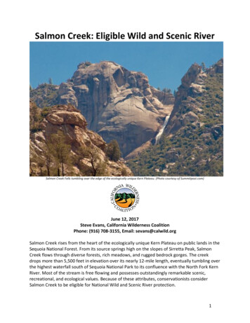
Salmon Creek: Eligible Wild and Scenic RiverSalmon Creek Falls tumbling over the edge of the ecologically unique Kern Plateau. (Photo courtesy of Summitpost.com)June 12, 2017Steve Evans, California Wilderness CoalitionPhone: (916) 708-3155, Email: sevans@calwild.orgSalmon Creek rises from the heart of the ecologically unique Kern Plateau on public lands in theSequoia National Forest. From its source springs high on the slopes of Sirretta Peak, SalmonCreek flows through diverse forests, rich meadows, and rugged bedrock gorges. The creekdrops more than 5,500 feet in elevation over its nearly 12-mile length, eventually tumbling overthe highest waterfall south of Sequoia National Park to its confluence with the North Fork KernRiver. Most of the stream is free flowing and possesses outstandingly remarkable scenic,recreational, and ecological values. Because of these attributes, conservationists considerSalmon Creek to be eligible for National Wild and Scenic River protection.1
Joe Fontaine has been working to protect the wild places of the Kern Plateau and the SequoiaForest for 60 years. He literally wrote the book on the Kern Plateau (The Kern Plateau andOther Gems of the Southern Sierra, 2009), and is the definitive expert on this wild landscape.Fontaine first started visiting the Kern Plateau in the 1950s by hiking up Salmon Creek from theNorth Fork Kern River to fish for golden trout. On some trips, he would backpack all the way toBig Meadow. According to Joe, “As strenuous as the hike was, the scenery was so inspiring, Inever passed up the chance to hike there.”Fontaine believes that Salmon Creek meets the required characteristics of Wild and ScenicRiver, from its source near Sirretta Peak, flowing through Big Meadow and Horse Meadow, andthen rumbling through the rocky gorge from which it tumbles over the edge of Plateau atSalmon Creek Falls. According to Mr. Fontaine, “There is no other stream on the Kern Plateauor elsewhere in the Sequoia National Forest with all those attributes in one watershed.”The Forest Service is required to assess rivers and streams for their Wild and Scenic Rivereligibility in the land and resources planning process. Initial screening conducted by the ForestService in 1991-92 determined Salmon Creek to be ineligible due to a supposed lack ofoutstandingly remarkable values. This determination was repeated in the 2016 DraftEnvironmental Impact Statement for Revision of the Inyo, Sequoia, and Sierra National ForestsLand Management Plans, Volume 2 Appendices (Forest Service, May 2016). However,conservationists believe that the assessment failed to consider relatively new informationconcerning the outstanding ecological values of Salmon Creek, as well as its well-knownrecreation and scenic values.Conservationists believe that an 11.1-mile section of Salmon Creek meets the two basic criteriafor Wild and Scenic eligibility. The creek is free flowing from its source on Sirretta Peak to SCE’sKern River 3 Hydroelectric Project diversion about ½ mile upstream of the creek’s confluencewith the North Fork Kern River. Using the Kern Plateau, Sequoia National Forest, and SierraNevada Province as the regions of comparison, Salmon Creek possesses outstandingremarkable scenic, recreation, and ecological values.OUTSTANDINGLY REMARKABLE VALUESEcological –There are no defined criteria for determining an outstandingly remarkable ecological value inagency guidelines. This report uses the general definition of an outstandingly remarkable valueprovided in the 1982 guidelines and Forest Service Handbook – a “river-related value that isunique, rare, or exemplary feature that is significant when compared to similar values fromother rivers at a regional or national scale.”Salmon Creek is a major stream that rises from the heart of the ecologically unique KernPlateau. The Kern Plateau is home to numerous plants and animals with limited endemicdistribution. The plateau is a hot spot for endemic species because it is an ecological island that2
provided favorable habitat through the last Ice Age, during which time relicts were preservedand specializations evolved.1 It remains an ecological island today due to higher elevations tothe north and lower elevations to the east, south, and west, which result in significantlydifferent precipitation and vegetation patterns that isolate the area.Although there are larger and longer streams draining the plateau, Salmon Creek experiencesperhaps the greatest range of elevation change than any other stream on the plateau,beginning at 9,000 feet elevation and dropping more than a mile to its confluence with theNorth Fork Kern River below 3,500 feet elevation. Along the way, the creek flows through fourlife zones (sub-alpine, upper montane, lower montane, and foothill woodland/chaparral),which support diverse ecosystems and equally diverse plant and animal species.The unique ecology of the Kern Plateau is demonstrated by the unusual occurrence of thePacific fisher. Models show little suitable habitat on the Plateau for this sensitive forestcarnivore but sightings have been numerous and persistent. The Kern Plateau is ecologicallydistinct from other fisher habitat areas, with less precipitation, gentler and less incised terrain,and perhaps different vegetation composition and structure.2 The Plateau encompasses theonly core habitat area for Pacific fisher not on the west slope of the Sierra Nevada, and itslocation on the Kern Plateau confirms unique environmental conditions compared to the westslope cores.3 Salmon Creek flows through the southern portion of this core habitat for Pacificfisher.Salmon Creek is the best representative example of the ecological diversity of the streamsdraining the plateau. The stream’s source is within the Twisselmann Botanical Area. Altogether,six plant associations are represented in the Botanical Area. These plant associations form aunique mosaic of vegetation in the southern Sierra Nevada. The plant associations includefoxtail pine forest, subalpine/mixed conifer forest, red fir forest, rock outcrop, montanechaparral, and mountain meadow-streambank. The area represents the southern-most limit ofboth the foxtail pine and limber pine.In addition to the unique associations of conifers, several plants in the Botanical Area constitutephytogeographical records. More than 70 species of plants have been identified in this area andits mountain meadows may contain a variety of unidentified additional species.4 The BotanicalArea provides a unique and high value special resource that contributes to the wildernesscharacter of the Woodpecker roadless area (Domeland West addition) and Salmon Creekthrough which it flows.51ndA Natural History of California (2 Edition) by Allan A. Schoenherr, UC Press July 2017, pgs. 168-169Baseline Evaluation of Fisher Habitat and Population Status in the Southern Sierra Nevada, by Wayne Spencer et al, Region 5 USDAForest Service, December 2007.3Southern Sierra Nevada Fisher Conservation Strategy, by Wayne Spencer at al, Fisher Interagency Leadership Team, Feb. 2016.4Sequoia National Forest Land and Resource Management Plan, Chapter 7, Volume 1 FEIS Appendix H, Evaluation of the TwisselmannBotanical Area, Forest Service 1988.5Inyo, Sequoia, Sierra National Forests Land Management Plans Revision DEIS, Vol. 2, Appendix B, May 2016, polygon 1394.23
Salmon Creek flows through a variety of habitats, including meadows, that support a highdiversity of butterfly species. The mountainous region of Kern and Tulare Counties provides therichest area for butterflies, many of which occur only in California and some only in this region.Many butterfly species reach the southern limits of their range on the plateau. Butterfly countshave been as high as seventy species identified in a day along the Sherman Pass Road. Themeadow systems along Salmon Creek provide rich habitat for butterflies, with Big Meadowsupporting 55 or more species.6Big Meadow was formed by a prehistoric blockage of Salmon Creek. Located at 8,000 feet inelevation, this large meadow is surrounded by forest and high granite peaks. Big Meadowoffers habitats for an exceptional number of plant species. More than 283 species of plantshave been identified in Big Meadow and its immediate borders. This list includes not onlycommon plants such as lodgepole pine, but also representatives of subalpine and even alpineflora.7Downstream of Big and Horse Meadows, Salmon Creek enters the Cannell Peak roadless area,which the Forest Service describes as “a complex unit with an incredible diversity of plants andanimals related to elevation and large open meadows that provide prime habitat for severalspecies of salamanders and the mountain yellow-legged frog.”8 It’s likely that the segment oflower Salmon Creek that flows through the Cannell Peak area shares these ecologicalattributes.Collectively, these resources constitute an outstandingly remarkable ecological value within thecontext of the Kern Plateau, Sequoia National Forest, and the Sierra Nevada province.Scenery –Forest Service criteria for identifying outstandingly remarkable scenic values include notable orexemplary visual features or attractions, which may encompass landforms, vegetation, water,color, and related factors. Seasonal variations in vegetation, scale of cultural modifications, andthe length of time negative intrusions are viewed, may also be considered. Scenery and visualattractions may be highly diverse over different parts of the river or river segment and scenicfeatures need only occupy a small portion of a river corridor.Forest Service documents indicate that the entire Salmon Creek corridor has distinctive VarietyClass A scenery. Attractiveness of the corridor is enhanced by the diversity of features thatinclude jagged rock outcrops and peaks, bedrock gorges with cascades and pools, Salmon CreekFalls, and Big Meadow.9 The outstanding scenery of Salmon Creek changes every few miles,from diverse sub-alpine forests, to lush meadows of varying sizes, granite bedrock gorges, and6Lepidoptera of North America. 3.4 Butterflies of Kern and Tulare Counties, California (Revised), by Ken Davenport, C.P. Gillette Museumof Arthropod Diversity, Colorado State University, Jan. 25, 2014.7The Kern Plateau and Other Gems of the Southern Sierra, by Joseph B. Fontaine, 2009.8Ibid. 59Eligibility Analysis – Field Verification, Cannell Meadow Ranger District, Cheryl Bauer, April 12, 1993.4
numerous large and small cascades and waterfalls. The creek flows through Big Meadow, oneof the largest wet meadows in the southern Sierra Nevada. Big Meadow is surrounded bygranite ridges, high steep rock outcrops, and lush forests that give the meadow an unusuallydramatic setting.10Salmon Creek departs the Kern Plateau in a spectacular display over the 450-foot-high SalmonCreek Falls – the highest water fall in the southern Sierra south of Sequoia National Park.11 Thefalls are one of the great natural features of the southern Sierra.12 Forest visitors are apprisedof the scenic view of Salmon Creek Falls by a sign on the Kern River Highway. Before tumblingover the falls, Salmon Creek cascades through a series of scenic “teacups” carved into thebedrock granite.The diverse scenery of Salmon Creek is significantly different from the scenery found alongexisting and generally much larger Wild and Scenic Rivers in the Sierra Nevada, including theNorth and South Forks of the Kern River and the Kings River to the north. This makes thescenery of Salmon Creek outstandingly remarkable within the context of the Kern Plateau,Sequoia National Forest, and the Sierra Nevada Province.Recreation –Forest Service criteria for identifying outstandingly remarkable recreation values include highquality recreational opportunities that attract, or have the potential to attract, visitors fromthroughout or beyond the region of comparison. Recreational opportunities are unique or rarewithin the region. River-related recreational opportunities include, but are not limited to,sightseeing, interpretation, wildlife observation, camping, photography, hiking, fishing, hunting,and boating. The river may provide settings for national or regional use or competitive events.Recreation opportunities along Salmon Creek are as diverse as its scenery and ecologicalvalues. Trails parallel or are close to much of the creek, and the well-maintained road systemprovides easy access to trailheads, developed campgrounds, and dispersed camping areasfound along the stream. The trail system also provides access to the primitive recreationopportunities found in two roadless areas.The Cannell Meadow National Recreation Trail (3E32) and the Sirretta Peak Trail (34E12)provide access to the upper portion of the creek in the Woodpecker roadless area (akaDomeland West addition). The Cannell Meadow NRT is open to hikers, motorcycles, mountainbikes, and equestrians. Slated for closure to motorcycles under the Mediated SettlementAgreement, the Sirretta Peak Trail provides access to the Twisselmann Botanical Area, whichattracts botanists from outside the region. The trail also accesses Sirretta Peak, which claims acommanding spot on the Kern Plateau and one of the best viewpoints in the entire southern10The Kern Plateau and Other Gems of the Southern Sierra, by Joseph B. Fontaine, 2009.WorldWaterfallDataBase.com; Self Propelled in the Southern Sierra, by J.C. Jenkins, Wilderness Press, 1984.12http://kernriversierra.com/hike/rincon trail.html115
Sierra.13 Outstanding views of Big Meadow and the nearby granite domes of the DomelandWilderness are important features of this trail.14 Because it flows through a roadless area, thissegment of Salmon Creek provides opportunities for solitude and for primitive and unconfinedrecreation.15The Cannell Meadow NRT follows Salmon Creek downstream past dispersed camping areasfavored by equestrians and other, and skirts around scenic Big Meadow. Fishing Salmon Creekin and around Big Meadow for non-native brown trout attracts visitors from outside theregion.16 The Salmon Creek Trail (33E36) begins on Road 22S12 on the edge of Big Meadow.The trail initially bypasses the rugged granite gorge through which Salmon Creek flows justdownstream of Big Meadow, but then returns to and crosses the creek and proceedsdownstream through dense forest and stringer meadows. The trail continues past the old KVCamp, Horse Meadow Campground, and through bucolic Horse Meadow, which in season isspangled with wildflowers. Much of this segment of Salmon Creek could be accessible to thephysically challenged at many locations, and is ideal for providing improved ADA access. Theold KV Camp could be an excellent future environmental education center or field station.A rough anglers trail follows Salmon Creek immediately downstream of Horse Meadow. Thisroute requires some scrambling on granite slabs along the creek, but it eventually meets upwith the rebuilt Salmon Creek Falls Trail (also 33E36) at its trailhead at the end of Road 23S08.This well-built trail starts high up on the canyon slope and enters the Cannell Peak roadlessarea, before dropping down to a crossing of Salmon Creek.As hikers proceed downstream from the crossing, the creek flows through lushly vegetatedforest and granite slides and pools, and then dramatically tumbles over the edge of the KernPlateau over a series of breathtaking waterfalls, including the highest in the southern Sierra.Although views of Salmon Creek Falls are limited from the trail, those with strong scramblingand rock climbing skills can climb the granite hill to the north of the creek to view the upperfalls. Anglers and swimmers may scramble down to the left to the scenic Salmon Creek teacups.Flows are highest in the spring, but the low summer flows are perfect for lounging in the small“teacup” pools.17This segment of Salmon Creek clearly attracts visitors from beyond the region. Ann MarieBrown, author of California Waterfalls (Foghorn Press, 2000) describes the Salmon Creek Trailto Salmon Falls as “a stellar walk through lodgepole pines and white fir, with a chance forfishing, skinny-dipping, and getting close to the lip of a big waterfall—my idea of a perfect daytrip or an easy one-night backpacking jaunt in early ta trail.htmlCalifornia Hiking, by Tom Stienstra and Ann Marie Brown, Foghorn Press, 1997.15Ibid. ealth-a-key-to-fishing-for-trout-in/article kernriversierra.com/hike/Salmon Creek Falls hike.html146
Modernhiker.com, which primarily focuses on trails throughout southern California, featuresthe hike to lower Salmon Creek Falls. It describes the route to the lower falls as “A short andstrenuous little-known trip to an incredible secluded canyon waterfall in the southern SequoiaNational Forest, just north of Kernville you get to see an unbelievable canyon with a majesticwaterfall (and sometimes TWO waterfalls in wet years!) in a secluded grove A surprising andwonderful hike!”18The lower segment of Salmon Creek is framed by dramatic rock formations that define the edgeof the Kern Plateau. Below the falls, the creek is accessible via SCE’s KR3 aqueduct service roadand the Rincon Trail. Again, direct access to the Salmon Creek Falls is limited but for thosewilling to do some rock scrambling, some breathtaking views are available. This segment ofSalmon Creek and the surrounding area is a popular destination for rock climbers. It is also thesite of the 2002 California Eco-Challenge Finals, which required a 500-foot rappel near thewaterfall and finding a cross-country route all the way down to the North Fork.19Visitors using the Rincon Trail may enjoy a long-distance view of Salmon Creek Falls and accessthe good fishing and camping prospects found along lower Salmon Creek downstream of thefalls.20 The multi-use Rincon Trail, which crosses Salmon Creek, is unique because it follows theRincon Fault, which defines the entire east slope of the North Fork Kern canyon.21Salmon Creek clearly possesses outstandingly remarkable recreation values within the contextof the Kern Plateau, Sequoia National Forest, and the Sierra Nevada Province. As documentedby numerous web sites and books, these outstanding recreation values attract visitors fromoutside the region.See Table 1 summarizing the outstandingly remarkable values (ORVs) of Salmon Creek, on page12.SEGMENTS AND CLASSIFICATIONSalmon Creek comprises three distinct segments based on the level of current developmentand resource management.Segment 1: This 1.7-mile segment begins at the creek’s source springs at about 9,000 feetelevation high on the south slope of Sirretta Peak and ends 300 feet north of the CannellMeadow National Recreation Trail (NRT) trailhead, approximately .25-miles upstream of the23S07 road crossing.The dominant feature of this segment is Sirretta Peak. No roads exist along this segment norare there any visible signs of development other than the Sirretta Peak Trail (34E12) and ersierra.com/canyoneering.html#salmon20Ibid. 14.21Ibid. 19197
Cannell Meadow NRT, which are only occasionally visible from the stream’s edge. The ForestService agreed to close the Sirretta Peak Trail to motorized (motorcycle) use as part of theMediated Settlement Agreement. The Sirretta Peak Trail currently exhibits little or no evidenceof motorcycle use. Most of Segment 1 is in the Woodpecker Inventoried Roadless Area (IRA)and adjacent roadless lands more recently inventoried by the Forest Service.22 The CannellMeadow NRT, a multi-use trail open to motorcycles and mountain bikes, is cherry-stemmedunder the RACR and in the more recent roadless inventory.Most of Segment 1 is currently managed for general dispersed recreation with a co-emphasison timber management, a Recreational Opportunity Spectrum (ROS) overlay of semi-primitivenon-motorized, and a visual quality objective of partial retention. This management has beenamended to protect the ecological values of the Twisselmann Botanical Area and roadconstruction is prohibited in this area under the Roadless Area Conservation Rule (RACR).23 TheMay 2016 draft Sequoia Forest Plan revision proposes to continue semi-primitive nonmotorized management with a high scenic integrity objective for the upper portion of thissegment (roughly parallel to the Sirretta Peak Trail) and roaded natural management with ahigh scenic integrity objective in the lower portion (roughly parallel to the Cannell MeadowNRT). Alternative C of the draft plan revision includes most of segment 1 as recommendedwilderness.24Tentative Classification – Segment 1 is proposed for Wild classification. The segment meets allWild classification criteria (free of impoundment, essentially primitive and inaccessible exceptby trail, little or no evidence of current or past logging, and the stream likely meets or exceedsfederal and state water quality standards). Motorized trails are permissible in Wild segments,particularly those that do not heavily invade the river corridor. Motorized use of the CannellMeadow NRT may continue under Wild classification and this use is consistent with current anddraft proposed management of this area.Left Picture: Salmon Creek’s source spring is in this high meadow in the Twisselmann Botanical Area. MiddlePicture: Sirretta Peak Trail. Right Picture: Salmon Creek’s segment 1 is small but nevertheless, the creek wasstill flowing in the driest year of a 5-year drought.22RARE II, U.S. Forest Service, 1977, RA # 5206; Inyo, Sequoia, Sierra National Forests Land Management Plans Revision DEIS, Vol. 2,Appendix B, May 2016, polygon 1394.23Sequoia National Forest Land and Resource Management Plan and FEIS, U.S. Forest Service, March 1988; Roadless Area ConservationRule, U.S. Forest Service, 200124Draft Revised Land Management Plan for the Sequoia National Forest and DEIS for Revision of the Inyo, Sequoia, and Sierra NationalForests Land Management Plans, Vol. 2, Appendix B, U.S. Forest Service, May 20168
Segment 2: This 4.1-mile segment begins 300 feet north of the Cannell Meadow NRT trailheadapproximately .25-miles upstream of the 23S07 road crossing and ends at the western edge ofHorse Meadow.The primary features of this segment include Big Meadow and Horse Meadow, and the ruggedgranite gorge downstream of the Road 22S12 crossing. The 23S07 and 22S12 roads cross thecreek over culverts upstream and downstream of where this segment flows through BigMeadow. A short spur road parallels the creek from the 23S07 road to the Cannell MeadowNRT trailhead and the land along this section of the creek accommodates dispersed camping byequestrians and others. Big Meadow is grazed under a Forest Service permit and access roads,fences, and structures associated with grazing management are nearby and visible. A largeearthen embankment that holds the 22S12 culvert in place may act as an unintended andtemporary impoundment of Salmon Creek during peak run-off. The Salmon Creek Trail (33E26)parallels part of the creek between the Road 23S13 crossing and Horse Meadow Campground.The old KV Camp is located near this segment but is visually screened from the creek. HorseMeadow Campground is located directly on the creek and vacation cabins on private inholdingsin and around Horse Meadow are visible in places from the streambank.Segment 2 is currently managed for general dispersed recreation with a co-emphasis on timbermanagement, a ROS overlay of roaded natural, and a visual quality objective of partialretention. The area immediately adjacent to the Horse Meadow Campground is allocated todeveloped recreation. The revised draft plan proposes to continue roaded natural managementwith a high scenic integrity objective.Left Picture: Joe Fontaine in Big Meadow – the high peak to the left is Sirretta Peak and the drainage to the right ofSirretta is upper Salmon Creek. Middle Picture: Salmon Creek at the western edge of Horse Meadow. Right Picture:Horse Meadow Campground sign, emblematic of this segment’s outstanding recreational value.Tentative Classification – Segment 2 is proposed for Recreational classification, primarily inrecognition of nearby roads and two culverted road crossings (one quite large that may act asan unintentional impoundment), as well as with grazing improvements and management in BigMeadow. Downstream of Big Meadow, two road crossings, the nearby presence of the old KVCamp and Horse Meadow Campground, and summer cabins on the private inholdingencompassing part of Horse Meadow also contribute to this segment’s Recreationalclassification. The segment meets all Recreational classification criteria (some evidence ofimpoundment or diversion but generally natural and riverine in appearance, some substantial9
evidence of human activity, including past and ongoing evidence of logging and grazingmanagement, readily accessible by road).Segment 3: This 5.3-mile segment begins at the west edge of Horse Meadow to .25 milesupstream of SCE’s KR3 diversion and aqueduct access road.The primary features of this segment include the rugged bedrock canyon through which thecreek flows and numerous cascades and waterfalls, including the 450-foot high Salmon CreekFalls. The lower portion of this segment is framed by dramatic rock formations that define theedge of the Kern Plateau. Most of this segment flows through the Cannell Peak roadless areaand more recently inventoried adjacent roadless lands.Most of Segment 3 is currently managed for general dispersed recreation, wildlife/dispersedrecreation, and grazing, with a co-emphasis on timber management, a ROS overlay of roadednatural and semi-primitive motorized, and a visual quality objective of partial retention. Withinthe Cannell Peak roadless area, this management has been amended by the RACR to prohibitroad construction. The draft Sequoia Plan revision allocates this segment to semi-primitivemotorized management with a high scenic integrity objective. Most of the Cannell Peakroadless area is recommended for wilderness protection under Alternative C of the draftrevised plan.Left Picture: Salmon Creek flows through a bedrock gorge downstream of Horse Meadow. Middle Picture: Thebeautiful Salmon Creek “teacups” upstream of Salmon Creek Falls. Right Picture: Middle Salmon Creek Falls.(Middle and right pictures courtesy of KernRiverSierra.com).Tentative Classification – Segment 3 is proposed for Wild classification, primarily in recognitionthat much of this segment flows through the Cannell Peak roadless area and more recentlyinventoried adjacent roadless lands. The only motorized trail in this segment is the Rincon Trail,which crosses but does not parallel Salmon Creek. Motorized trails are permissible in Wildsegments, particularly when they do not heavily invade the river corridor. This segment meetsthe basic criteria for Wild Rivers, including essentially primitive with little or no evidence ofhuman activities, little or no evidence of past or ongoing timber harvest, and generallyinaccessible except by trail. Portions of the 23S08 road leading to the Salmon Falls Trailhead arewithin ¼ mile of the creek, but the road is located sufficiently high up on the canyon slope to beinvisible from the creek and for motorized used to occur unheard. The Wild River corridorboundary may be easily adjusted to exclude this road.10
CONCLUSIONSalmon Creek from its source on Sirretta Peak to point upstream of SCE’s KR3 diversion is freeflowing. We believe that Salmon Creek possesses outstandingly remarkable ecological scenic,and recreation values. This 11.1-mile section of Salmon Creek should be determined eligible forWild and Scenic River protection in the upcoming Sequoia National Forest draft supplementalplan revision scheduled to be released for public review in early 2018.Clockwise from top left: Salmon Creek below Horse Meadow. Cannell Meadow Trailhead sign 300 feet downstreamof the end of segment 1. Salmon Creek in Horse Meadow. Bigelow’s sneezeweed in a small meadow along theSirretta Trail.About the author: Steven L. Evans is a consultant on public lands and river conservation issues for CalWild. He hasmore than 40 years of professional and volunteer experience protecting and conserving public lands, Wild andScenic Rivers, and Wilderness.11
TABLE 1: SUMMARY OF SALMON CREEK’S OUTSTANDINGLY REMARKABLE VALUES (ORVs)ECOLOGICAL ORVsSCENIC ORVsRECREATION ORVs1.2.3.4.5.6.Located in the Kern Plateau “ecologicalisland” and is the best example ofecologically diverse Plateau streams.Drops 5,500 feet in 12 miles, flowingthrough four life zones, with widediversity of plants and animals, manywith limited endemic distribution.Flows through the eastern-most andecologically distinct habitat for Pacificfisher.Source located in TwisselmannBotanical Area, which supports uniqueassociation of conifers and plants,including the southern-most limit offoxtail and limber pine.Flows through Big Meadow, whichsupports a high diversity of butterfliesand an exceptional number of plantspecies.Flows through the Woodpecker andCannell Peak roadless areas, whichsupport a high diversity ofplant/animal diversity contributing towilderness character of Wildsegments.1.2.3.4.5.Entire stream corridor hasdistinctive variety class A sceneryenhanced by diverse features.Diverse scenery changes every fewmiles due to elevation changes,geographic features, and vegetation.Big Meadow located in an unusuallydramatic setting, including lushforests, granite ridges and rockoutcrops.Tumbles off the edge of the KernPlateau over 450-foot high SalmonCreek Falls, the highest waterfallsouth of Sequoia-Kings CanyonNational Park.Many smaller waterfalls, cataracts,and eroded bedrock pools (teacups).1.2.3.4.5.6.7.Offers diverse recreationalopportunities, including hiking,backpacking, moun
Salmon Creek Falls tumbling over the edge of the ecologically unique Kern Plateau. (Photo courtesy of Summitpost.com) June 12, 2017 Steve Evans, California Wilderness Coalition Phone: (916) 708-3155, Email: sevans@calwild.org Salmon Creek rises from the heart of the ecologically unique Kern Plateau on public lands in the Sequoia National Forest.