Transcription
If you have no further use for this report after it has served your purpose, please return it tothe Geological Survey, using the official mailing label at the end.UNITED STATES DEPARTMENT OF THE INTERIORIGNEOUS GEOLOGY AND STRUCTUREOF THEMOUNT TAYLOR VOLCANIC FIELDNEW MEXICOGEOLOGICAL SURVEY PROFESSIONAL PAPER 189—B
IGNEOUS GEOLOGY AND STRUCTURE OF THE MOUNT TAYLOR VOLCANIC FIELD,NEW MEXICOBy CHARLES B. HUNTABSTKACTThe Mount Tftylor volcanic field is situated in northwesternNew Mexico and embraces a part of the south flank of the SanJuan Basin and the adjoining part of the block-faulted RioGrande Valley. Most of the volcanic field is in the ColoradoPlateau province, but the eastern part is in the Basin and Rangeprovince. The boundary between the two provinces is clearlymarked topographically and geologically. A variety of landforms and several different types of drainage patterns representedin the area are due to differences in resistance and structuralattitude of the rocks.The sedimentary rocks in the field consist chiefly of UpperCretaceous sandstone and shale, the Santa Fe formation of lateMiocene and Pliocene age, and some younger deposits of probablePleistocene age; also small areas of the Morrison formation, ofUpper Jurassic age. Volcanic rocks were erupted at differenttimes in this area. Probably the first eruptions were those ofthe Mount Taylor volcano, in Miocene time, which began withrhyolitic tuffs and trachyte, continued with a series of latites,and concluded with porphyritic andesite. The tuffs, trachyte,and latites apparently came from a central pipe and crater inMount Taylor, but the porphyritic andesite was erupted mostlyfrom fissures radiating from the pipe. The tuff and lava eruptedby Mount Taylor accumulated in a cone whose top has beenconsiderably lowered by erosion. The cone is estimated to haveincluded originally at least 12 cubic miles of the eruptives.The Mount Taylor eruptions were followed, probably inPliocene time, by a large number of basalt sheets erupted by smallvolcanoes distributed around Mount Taylor. These sheets ofbasalt were erupted on erosion surfaces cut around the MountTaylor cone. A few of the sheets preceded the latest flows ofporphyritic andesite from Mount Taylor, and one precededthe rhyoliUijj- but most of them were erupted after Mount Taylorhad become quiescent. The sheets were supplied by many smallvolcanoes, mostly of the central type, although a few fissureeruptions are knojyn.Since the eruptions streams have cut downward nearly 2,000feet, and the lava sheets now cap high mesas. On these lavacapped mesas the volcanoes are marked by cones of lava andscoriae. Where the lava has been completely removed the oldvolcanoes are marked by isolated necks. The most conspicuousnecks are composed almost entirely of basalt; others includebasaltic breccia with the basalt, and still others are mostlybasaltic breccia. There is practically no deformation of thecountry rock adjacent to these intrusions. The breccia isbelieved to be a nonextruded byproduct of a quiet intrusiveprocess.Folding has been the predominant type of structural deformation of the rocks in the Colorado Plateau portion of the MountTaylor volcanic field, but faulting has been the predominanttype in the Basin and Range portion. The Mount Tayloreruptions jferb preceded by regional northward tilting, byfolding of 'the McCarty syncline, and by folding and associatedfaulting west of the syncline and gentle warping east of thesyncline. Probably moist of the displacement along the faults150009—38in the Basin and Range part of the field preceded the MountTaylor eruptions also, but after those eruptions there was renewedminor folding and faulting in the McCarty syncline, minorfaulting in the gently warped area east of the syneline, andcontinued faulting in the eastern part of the volcanic field- Thefaulting in this part of the area continued during the depositionof the Santa Fe formation and some deposits that are probablyyounger than the Santa Fe.INTRODUCTIONLOCATION OF THE AREAThe Mount Taylor volcanic field, named from MountTaylor, its largest volcano and most conspicuous topographic feature, includes an area of about 2,000 scuaremiles in northwestern New Mexico midway betweenAlbuquerque and Gallup. The area lies north of th«valley of the Rio San Jose. This valley is used by theAtchison, Topeka & Santa Fe Railway and UnitedStates Highway 66 for their approach to the Continental Divide, which crosses the northwest corner cf thevolcanic field. (See fig. 3.)From the village of Grant, 15 miles southwest ofMount Taylor, the western and southwestern parts ofthe volcanic field are easily accessible. A Forest Service road from Grant extends within 4 miles of MountTaylor Peak. A graded road, not fully shown onplate 7, leads from Grant to San Mateo, whence otherroads lead northward along the west side of MesaChivato and eastward onto the mesa. Laguna and theLaguna Indian pueblo, south of the field, are the beststarting points for visiting the east side of Mount Taylorand Mesa Chivato. Stage roads lead northward as faras Marquez. New Mexico State Highway 6, the mostdirect road west from Albuquerque, crosses the southeast corner of the area shown on plate 7. The northernparts of the area can best be reached from San Yfidro,on State Highway 44, or from Cabezon, which is connected by a fair road with that highway.PRESENT INVESTIGATIONThe field investigation on which this report is l sedwas begun in 1930, with the assistance of D. A, Andrews, R. W. Brown, and W. S. Pike, Jr. In that yearthe portion of the volcanic field north and northwest ofMesa Chivato and also a strip about 10 miles wide alongthe east side of the mesa, including the many volcanicnecks, were mapped, In 1931 the field investigation51
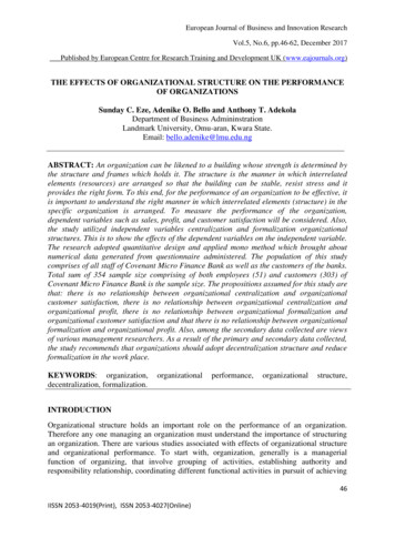
52SHORTER CONTRIBUTIONS TO GENERAL GEOLOGY, 1937was resumed with the assistance of H. R. Joesting,R. C. Becker, J. W. Wyckoff, and G. F. Taylor; thecountry along the south side of Mount Taylor and eastof the mountain as far as the eastern border of the UpperCretaceous formations was mapped.The field investigations of 1930 and 1931 formed apart of ths Geological Survey's regular program of sur-determinations. During these two seasons several tripswere made into the flanks of the Mount Taylor volcano,but only very general relations were noted. The numerous volcanic necks northeast of Mount Taylor wereexamined more carefully in connection with the detailedmapping.Returning in 1932, I was able to spend 3 weeksJD SandiaI fV!t/s/AMiguerque/FIGUBE 3.—Index map of New Mexico showing the location of the Mount Taylor volcanic field (stippled) and the approximate boundariesof the physiographic provinces.veys for the claszification of public lands with referenceto fuel and other mineral resources. The energies of thefield parties were therefore confined mostly to the mapping of the sedimentary rocks. The mapping was doneby plane-table methods on a scale of 1:62,500 and consisted of careful lateral tracing of formation boundariesand carrying altitudes on these horizons for structuralin studying the Mount Taylor volcano and the latereruptives immediately surrounding it. I iring thisstudy sketch maps were made of the field relations, andanother week was spent hi obtaining additional information on the volcanic necks east of Mesa Chivato.The present report therefore includes the results ofboth detailed and reconnaissance studies, and in the
CONTENTSAbstract. - - -- ---- -.-.--- .-- -------Introducticjtr v- -- - - ---- ------ ----- ----Location of the area - --- ----- --- --- ----Present investigation--- - - - - ---- - --------- - ---.-Previous investigations. - -- ----- ------------- ----Geography— ———— - - -- -- — ———————— --——Geomorphic location- - . ----- ------------- ----Land forms.Drainage . -- --- ------- ----- -.----Climate and vegetation ! - - --- - -- ---- ----Summary o,f the late Tertiary and Quaternary history --- --------- --.----Chronology of events.-- - -- ------ -------------- ---------Age alignments.Volcanic activityPage5151515153545454555656565657General chronology. - --- ----- ---- - ----The Mount Taylor volcano . - - - ----------- -----Rhyolitic tuff. „ - --- - --- --------------Trachyte-- . .Latite series. . - -- -- --- - -- - ----Porphyritic andesite series. -- ---------- - ---- -----------Summary of Mount Taylor eruptions - - ------ -----------------Sheet basalt. . .Basalt in the amphitheater .- - - ------ --. -----Vents on the north flank of Mount Taylor - - - - - ------------ ----Flows on Mesa Chivato --- - -- --- --------La Jara Mesa. --- -- --- --- -- - ----Grant Ridges. —Horace Mesa --- - -- -------------The volcanic necks --- - -- --- - - ---- Cabezon Peak - -- - ---- ------------Cerro de los CuatesNeck in Gonzales CanyonLa Sefiora Peak- - -- ------------- ----Seboyeta Peak .Basaltic rocks by New Mexico State Highway 6 -- - - - -- - ---------- ---------.-----------Sierra Alesna. - ----- ----- - -- -- ----Other volcanic necks - - -- - - --- ----------Basaljp;i kes- -Origi i of the breccia.Summary of basalt eruptions iRecent flows. - r - - - --- - --------Structural geology.General structural relations of the volcanic field- - - -- ------ -----------------Colorado Plateau portion of the field - - ------ --- - ------------McCarty syncline-- . - --- - ---- --- - ----Minor folds within McCarty syncline - - ---------- -------------- ----Fo ch northwest of McCarty syncline -- - ---- -------- ------ ---(i«ii%le warping east of McCarty syncline- .-- --- ----------------- --------Basin s and Range portion of the field - - - - ----- - -------- -------General structural relations . - - -- - --- --- -- - -Faults . - ---Folds.-. --- -Age of the deformation - -- - - ---- - - --- ----Possible significance of the structural features- - - --- - ------ ------ ---------—Index--. . 273737373747474757576767676777879in
ILLUSTRATIONSPLATE7. Map showing structure and reconnaissance areal geology of the volcanic rocks of the MountN. Mex . In pocket8. A, View of Mount Taylor; B, View looking northeast across erosion surface in Lobo Canyon '-549. Map showing drainage in Mount Taylor volcanic field - -- - - - - -- - - -------- - ----5410. A, Porphyritic andesite flows near base of north flank of Mount Taylor; B, V-shaped valley cut in porphyriticandesite.5411. A, Cross section of basaltic neck exposed by erosion in Grant Ridges; B, Cliff face exposing basaltic breccia onrhyolitic tuff near the volcanic neck - -- - - ----- --- - -- --.5412. A, Basaltic lava and cinder cone on the sheet basalt capping Horace Mesa; B, View looking northeast froar,, topof volcanic neck east of La Abra de los Cerros; C, View looking south from Cerro de los Cuates. i 1.:-6213. A, Cabezon Peak viewed from the bluffs above the village of Cabezon; B, Closer view of south side of CafcezonPeak showing fairly uniform vertical columns capped with a layer of scoriaceous basalt - ' .6214. A, Volcanic neck east of La Abra de los Cerros; B, Xenolith of fossiliferous Cretaceous sandstone in basaltic brecciain neck in Gonzales Canyon - - -- - ------7015. A, B, Views of Evans Peak .7016. A, View looking southwest toward Seboyeta Peak; B, Xenoliths of sedimentary rock in breccia along east side ofSeboyeta Peak7017. A, Dike of basalt and basaltic breccia intruding Cretaceous shale; B, Banded basaltic breccia lying at outer contactof large breccia mass; C, D, Angular unconformity between Santa Fe formation and underlying Cretaceousrocks7018. A, Block diagram showing structural surface of part of Antonio Sedillo Grant at southwest corner of the a e ; B,Block diagram showing structural surface of most of north hah* of Basin and Range part of Mount Taylor volcanic field - 7819. A, Flat-lying unbroken Santa Fe formation crossing a normal fault in Cretaceous shale; B, Basaltic lava in FantaFe formation tilted and broken by small fault -. - --- -- ------- - -- ------ ---78FIGURE 3. Index map of New Mexico showing location of Mount Taylor volcanic field- - - - -- ---524. Diagrammatic view of part of Mount Taylor volcanic field545. Sketch showing topographic relations in Lobo Canyon- - -- -- - ---- -- --- - -- -------.- --556. Pedestal of alluvium about 50 feet high left standing in Chico Arroyo, 3 miles west of Cerro de los Cuates —567. Arroyo of Rio Puerco 2 miles north of Ojito ranch - -- - - --- ----------568. Sequence of late Tertiary and Quaternary events in Mount Taylor volcanic field.579. Hypothetical profile of Mount Taylor - - - -- -- --- - --- -- -----------5810. Geologic sketch map of amphitheater and surrounding rim of Mount Taylor volcano5911. Sketch map showing intrusive basaltic breccia in Gonzales Canyon - -6912. Diagrammatic section through north side of Juan Tafoya Peak - - - - - --- --- - -7113. Diagram of columnar jointing in intrusions 4 miles east-northeast of La Sefiora Peak. r7114. Sketch from photograph showing fault relations half a mile west of San Ysidro and 1,000 feet north of Statef 4ghway 44 . - .,7715. Diagrammatic section illustrating faulting east of Mesa Lucero - - - -- -- -- --- --- - 77IV
IGNEOUS GEOLOGY AND STRUCTURE OF MOUNT TAYLOR VOLCANIC FIELD, N. MEX.descriptions an effort is made to indicate the degree ofcompleteness of the observations.PREVIOUS INVESTIGATIONSNumerous reports contain references and descriptionsof the Mount Taylor volcanic field. The earliestdescribe the general appearance of the area as viewedfrom the nearby routes of travel. Subsequent reportsgive fulled accounts of the geology, but most of themwere written to emphasize some specific problem of thearea. The reports are summarized as follows:Simpson, J. H., Journal of a military reconnaissance from SantaFe, N. Mex., to the Navajo country: 31st Gong., 1st sess., S. Ex.Doc. 64, pp. 56-138, 146-148, 1850. Mount Taylor is named inhonor of th President, and there is brief mention of the kinds ofrock enoouritered along the line of march.Marcou, Jules, Re'sume of a geological reconnaissance extending * * * t0 the pueblo de los Angeles in California: U. S.Pacific R. R. Expl., 33d Gong., 2d sess., S. Ex. Doc. 78, vol. 3,pt. 4, pp. 165-171, 1856. Mount Taylor is identified as a volcaniccone. On the basis of fossils Jurassic and Cretaceous ages areassigned to the older rocks exposed in the valley south of MountTaylor.Marcou, Jules, Geology of North America, Zurich, 1858. Thisreport contains the first geologic map and cross section of thispart of the country. In the cross section Mount Taylor is shownas a volcano.Newberry, J. S., Geological report, in Ives, J. C., Report uponthe Colorado River of the West, pt. 3, pp. 65-66, 1861. Containsa description of Mount Taylor as viewed from the San JoseValley.Newberry, J. S., Geological report, in Macomb, J. N., Reportof the exploring expedition from Santa Fe, N. Mex., to junctionof the Grand and Green Rivers of the great Colorado of the Westin 1859, pp. 9-118, 1876. Describes the appearance of MountTaylor as viewed from the northeast corner of the volcanic field.Howell, E. E., U. S. Geog. and Geol. Surveys W. 100th Mer.Rept., vol. 3, pp. 227-301, 1875. Recognizes the fact that theeruptions of the Mount Taylor volcano were later than the foldingof the Cretaceous strata and that the sheet basalts were later thanMount Taylor. Also calls attention to faulting in the easternpart of the area.Dutton, C. E., Mount Taylor and the Zufii Plateau: U. S.Geol. Surveiy 6th Ann. Rept., pp. 105-198, 1885. The first complete desertion of the geology of the volcanic field is in thisreport. Discussion is centered around the volcanic rocks, however, with only passing mention of the sedimentary rocks. Includes a very satisfactory geologic map with topographic contourscovering Mount Taylor and the Zufii Mountains.Emmons, S. F., and others, Geological guidebook of the RockyMountain excursion (5th Internat. Geol. Cong., Washington,1891), pp. 468-471, John Wiley & Sons, 1893. Includes a description, by G. K. Gilbert, of the appearance of the MountTaylor area as viewed from the Rio San Jose.Herrick, C. L., The geology of the San Pedro and Albuquerquedistricts [N. Mex.]: Denison Univ., Sci. Lab., Bull., vol. 11, pp.93-116, 1898. Discusses stratigraphy of the Cretaceous strata.Herrick, C. L., and Johnson, D. W., The geology of the Albuquerque sheet [N. Mex.]: Denison Univ., Sci. Lab., Bull.,vol. 11, art. 9, pp. 175-239, 1900; New Mexico Univ., HadleyLab., Bull., vol. 2, pt. 1, pp. 1-67, 32 pis., with colored geologicmap, 1900. Discusses stratigraphy and paleontology of theCretaceous &Sta.Herrick, C. L.; Reports of a geologic reconnaissance in western53Socorro and Valencia Counties, N. Mex.: Am. Geologist, vol.25, pp. 331-346, pis. 8-60, 1900. Discusses stratigraphy of theCretaceous strata.Johnson, D. W., Block mountains in New Mexico: Am. Geologist, vol. 31, p. 137, 1903, Briefly mentions block faulting alongthe Rio Puerco in relation to the regional structure bf the RioGrande Valley at Albuquerque.Reagan, A. B., Geology of the Jemez-Albuquerque region, N.Mex.: Am. Geologist, vol. 31, pp. 67-111, 7 pis., 1903; IndianaAcad. Sci. Proc., 1902, pp. 187-197, 1903. Briefly mentionsCretaceous stratigraphy of the eastern part of the area in connection with regional correlation.Schrader, F. C., The Durango-Gallup coal field of Coloradoand New Mexico: U. S. Geol. Survey Bull. 285, pp. 2 1-25,8,1906. Demonstrates the continuity of the coal field betweenDurango, Colo., and Gallup, N. Mex.Johnson, D. W., Volcanic necks of the Mount Taylor region,N. Mex.: Geol. Soc. America Bull., vol. 18, pp. 303-324, 1907.Demonstrates that the volcanic necks east of Mesa Chivto arecorrectly interpreted as such and are not remnants of fiSws rlaccoliths.Shimer, H. W., and Blodgett, M. E., The stratigraphy of theMount Taylor region, N. Mex.: Am. Jour. Sci., 4th se ., vol.25, pp. 53-67, 1908. Describes and discusses significance offossils collected during the measurement of three seetfins ofCretaceous rocks in the Rio Puerco Valley.Gardner, J. H., The coal field between Gallup and San Mateo,N. Mex.: U. S. Geol. Survey Bull. 341, pp. 364-378; 190P; Thecoal field between San Mateo and Cuba, N. Mex.: U. S Geol.Survey Bull. 381, pp. 461-473, 1910. The coal-bearing Mesaverde formation is traced from Gallup to Cuba acro * thenorthern part of the volcanic field.Darton, N. H., A reconnaissance of northwestern New 1-fexicoand northern Arizona: U. S. Geol. Survey Bull. 435, p. 69. 1910.Gives general statements concerning the stratigraphy and structure of the eastern part of the Mount Taylor area.Lee, W. T., Stratigraphy of the coal fields of northern centralNew Mexico: Geol. Soc. America Bull., vol. 23, pp. 62 -629,1912. Discusses the regional correlation of the Upper Cretaceousformations present in the area.Stanton, T. W., Some variations in Upper Cretaceous stratigraphy: Washington Acad. Sci. Jour., vol. 3, pp. 60-61, 1913.Discusses the regional correlation of the Upper Cretaceous formations present in the area.Lee, W. T., Relations of the Cretaceous formations to theRocky Mountains in Colorado and New Mexico: U. S. Geol.Survey Prof. Paper 95, pp. 27-58,1916. Discusses the regionalcorrelation and sedimentation of the Upper Cretaceous formations in this area.Lee, W. T., and Knowlton, F. H., Geology and paleontologyof the Raton Mesa and other regions in Colorado and NewMexico: U. S. Geol. Survey Prof. Paper 101, pp. 195-198, 1917.Discusses the regional correlation of the Upper Cretaceous f rmations present in this area.Darton, N. H., Geologic structure of parts of New Mexico:U. S. Geol. Survey Bull. 726, pp. 257-265, 1922; "Red Beds"and associated formations in New Mexico: U. S. Geol. S irveyBull. 794, pp. 109-137, 1928. Describes the regional structureof the southern part of the area.Bryan, Kirk, Historic evidence on changes in the channel ofthe Rio Puerco, a tributary of the Rio Grande in New Mexico:Jour. Geology, vol. 36, pp. 265-282, 1928. Evidence showsthat before 1885 the valley floor of the Rio Puerco was e trueflood plain. Between 1885 and 1890 the channel was deepenedand widened, a process still continuing. Six small towns havebeen abandoned, and the others impoverished by the erosion,
54SHORTER CONTRIBUTIONS TO GENERAL GEOLOGY, 1937GEOGEAPHYGEOMORFHIG LOCATIONThe Mount Taylor field overlaps the southeastborder of the San Juan Basra and the northwest borderof the block-faulted Rio' ' ":,1 § Grande Valley. (See fig. s J 3.) It therefore includes3 g portions of both the Colo11 "i rado Plateaus and the03 . .u Basin and Range prov . § inces. The boundary beJ-1 § tween these two provinces § 1 is clearly marked geologio » «- cally in the area, a feature 8 s of some interest in view of g the uncertain boundary "11 that must generally beP c? drawn elsewhere in theg 2 2 State. The northeastern§ 11 part of the area adjoinsF*K1,3 g the Nacimiento uplift ofww the Southern RockyD. I g Mountain province. Z rrt*"e]t-4 }03O* 'IOLAND FORMSH r .H g 111 3 SS " 15iI S .2 1I 111 *i M « I12 '§ 11* »6 a w 11 I . .a-I g « s §rfo : o § §roro I 1 -g b § !Pf.1Cfl 31 S5 O'S 03The most prominenttopographic feature in thearea is the mountain forwhich the field was named.Viewed from a distanceM unt Taylor has a distinctly conical form, withextensive flat-topped foothills spreading away fromits base. (See pi. 8, A, andfig. 4.) The top of thecone consists of a series ofpeaks distributed along anarc concave to the east.Mount Taylor Peak, thehighest, stands on the westside of the arc and risesabout 11,350 feet above sealevel, a mile higher than theRio San Jose 12 miles tothe south. Within the arcis the crater of the old volcano. The crater has beenenlarged by erosion to forman amphitheater coveringnearly 5 square miles andabout 2,500 feet deep,drained eastward by WaterCanyon Creek, which hascut its way through the eastflank of the cone. In thisreport the term "MountTaylor" refers to the whole conical mountain mass andthus includes all the peaks in the arc, the amphitheater,and the rugged slopes down to the level of the foothills.The highest peak is called Mount Taylor Peak.Mount Taylor is surrounded by broad, flat-toppedfoothills capped with sheet basalt. (See fig. 4.) MesaChivato, the largest, extends northeastwari for about25 miles from the base of Mount Taylor and at mostplaces is more than 10 miles wide. From a distanceMesa Chivato appears as a nearly flat plateau, but closerviews reveal scores of lava and cinder cones, some a fewhundred feet high, marking the vents that supplied thebasaltic lava cap. The top of the. mesa is about 2,000feet above the surrounding country and 3,000 feetbelow the peaks on Mount Taylor. Th ? northern,eastern, and western limits of Mesa Chivato are distinct geologically and topographically, but the southernlimit will be drawn arbitrarily at Water Canyon andthe canyon that heads southeast of San Mateo.South of Mount Taylor flat-topped foothills cappedwith lava, mostly basalt, extend 10 miles from the baseof the cone to the valley of the Rio San Jose, the principal stream of this part of the area. The e foothills,deeply dissected by canyons, are exceedingly rough.San Fidel Mesa, between Water and Rinconada Canyons,is somewhat lower than Mesa Chivato, but Horace andLa Jara Mesas, southwest of Mount Taylor, have aboutthe same altitude as Mesa Chivato and slope gently awayfrom Mount Taylor. The Grant Ridges are smallerisolated mesas along the northwest side of the valleyheading northeast of Grant. Mesa Prieta, 15 miles eastof Mesa Chivato, is another high mesa capped withbasalt, but its top is considerably below Mesa Chivato.The boundaries of the foothills around Mount Taylorare located with fair accuracy on plate 7, but no instrumental control was extended to the tops of the broadfoothills. The topography of Mount Taylor as shownon plate 7 was sketched without instrumental controlon the United States Geological Survey reconnaissancetopographic map. The map, as thus mod;fied, represents some improvement over the earlier reconnaissancemap but still leaves much to be desired in the way ofprecise locations and delineation of land forms.The lavas capping the mesas are the most resistantrocks in the area. Erosion of the mesas har progressedalmost entirely by removal of the relatively soft sedimentary rocks, thus undercutting the resistant lava caps.Erosion by the Rio Puerco has produced a broad valleynearly 2,000 feet below the lava-capped Me as Chivatoand Prieta. The sedimentary rocks in the valley havebeen eroded to low relief, which emphasizes th e height of adozen peaks, volcanic necks of resistant lava, some ofwhich rise nearly 2,000 feet above the valley bottom.(See pi. 12, 0.) Elsewhere in the Mount Taylor volcanic field thesurface rocks are entirely sedimentary and consist ofmoderately resistant sandstones interbedded withthicker bodies of easily eroded shale. The character of
GEOLOGICAL SURVEYPROFESSIONAL PAPER 189PLATE 8A. VIEW OF MOUNT TAYLOR FROM A POSITION 25 MILES TO THE SOUTH.Photograph by W. S. Pike, Jr.B. VIEW LOOKING NORTHEAST ACROSS EROSION SURFACE IN LORO CANYON.This surface, capped with a very thin mantle of gravel, truncates northeastward-dipping beds of sandstone and shale. The high peak in the distance is Mount Taylor.
PEOFESSIONAL PAPEE 189GEOLOGICAL SUBVEYPLATE 10A. PORPHYRITIC ANDESITE FLOWS NEAR BASE OF NORTH FLANK OF MOUNT TAYLOR.View looking southwest near center of south line of sec. 9, T. 12 N., R. 7 W.B. V-SHAPED VALLEY CUT IN PORPHYRITIC ANDESITE,View near center of south line of sec. 31, T. 12 N., R. 7 W.The sky line at the head of the valley marks the rim of the amphitheater of the Mount Taylor volcano.
GEOLOGICAL StTRVE?PROFESSIONAL PAPER 189PLATE 11A. CROSS SECTION OF BASALTIC NECK EXPOSED BY EROSION IN GRANT RIDGES, 6 MILES NORTHEAST OF GRANT.View looking southwest in sec. 3, T. 11 N., R. 9 W. Basalt in core is jointed in vertical columns and surrounded by a thin zone of platy jointing developed along thecontact with white tuff. Bedded breccia overlies the tuff, and basaltic lava overlies the breccia on the far side of the cone. The tuff, chiefly rhyolitic, was eruptedfrom Mount Taylor. IfB. CLIFF FACE EXPOSING BASALTIC BRECCIA ON RHYOLITIC TUFF NEAR THE VOLCANIC NECK.In sec. 3, T. 11 N., R. 9 W.
IGNEOUS GEOLOGY AND STRUCTURE OF MOUNT TAYLOR VOLCANIC FIELD, N. MEX.the topography has been controlled by the number,thickness, and structural attitude of the sandstones.Northwest and southeast of Mount Taylor, where thereare many thick beds of sandstone with gentle dips,there are prominent mesas with steplike benches aroundthem. In the eastern part of the volcanic field a miniature Basin and Range topography has been formedwhere thick sandstone beds, steeply tilted in successivefault blocks, produce sharp parallel ridges betweenvalleys eroded in the shale.Lobo Canyon contains a notable exception to the general rule of structural control of the topography; therean erosion surface
ice road from Grant extends within 4 miles of Mount Taylor Peak. A graded road, not fully shown on plate 7, leads from Grant to San Mateo, whence other roads lead northward along the west side of Mesa Chivato and eastward onto the mesa. Laguna and the Laguna Indian pueblo, south of the field, are the best
