Transcription
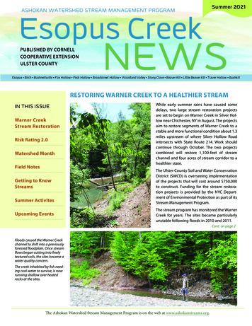
ASHOKAN WATERSHED STREAM MANAGEMENT PROGRAMSummer 2021Esopus CreekPUBLISHED BY CORNELLCOOPERATIVE EXTENSIONULSTER COUNTYNEWSEsopus Birch Bushnellsville Fox Hollow Peck Hollow Broadstreet Hollow Woodland Valley Stony Clove Beaver Kill Little Beaver Kill Traver Hollow BushkillRESTORING WARNER CREEK TO A HEALTHIER STREAMIN THIS ISSUEWarner CreekStream RestorationRisk Rating 2.0Watershed MonthField NotesGetting to KnowStreamsSummer ActivitesUpcoming EventsWhile early summer rains have caused somedelays, two large stream restoration projectsare set to begin on Warner Creek in Silver Hollow near Chichester, NY in August. The projectsaim to restore segments of Warner Creek to astable and more functional condition about 1.3miles upstream of where Silver Hollow Roadintersects with State Route 214. Work shouldcontinue through October. The two projectscombined will restore 1,100-feet of streamchannel and four acres of stream corridor to ahealthier state.The Ulster County Soil and Water ConservationDistrict (SWCD) is overseeing implementationof the projects that will cost around 750,000to construct. Funding for the stream restoration projects is provided by the NYC Department of Environmental Protection as part of itsStream Management Program.The stream program has monitored the WarnerCreek for years. The sites became particularlyunstable following floods in 2010 and 2011.Cont. on page 2Floods caused the Warner Creekchannel to shift into a previouslyforested floodplain. Once streamflows began cutting into finelytextured soils, the sites became awater quality concern.The creek inhabited by fish needing cool water to survive, is nowrunning shallow over heatedrocks at the sites.The Ashokan Watershed Stream Management Program is on the web at www.ashokanstreams.org.
Esopus Creek NewsWarner Creek Stream RestorationWhen the stream program began monitoring the sites a person could easily hopacross the creek, but 10 years later thechannel has widened to more than threetimes its original width.Warner Creek flows through Silver Hollow into the Stony Clove Creek at Chichester, which empties into the EsopusCreek at Phoenicia. Both streams arehistoric trout fisheries and recreationaldestinations that feed New York City’sAshokan Reservoir in northwest UlsterCounty.The Ulster County SWCD hired SLR Engineering to develop restoration designsfor the stream channel and banks. A construction contract was awarded to BakerBrothers Excavating, Kingston Equipment Rental in Hurley, NY to install bothprojects.The projects will re-create pool and rifflefeatures. These natural stream featuresstabilize the channel bed and providefish and aquatic insects with the habitatthey need.The benefits should extend well beyondthe sites. In addition to improving waterquality as far away as the Ashokan Reservoir, the projects should reduce an upstream source of cobble and wood thatmight otherwise cause erosion where itaccumulates at downstream properties.The SWCD will monitor the sites for yearsafter construction to evaluate how theprojects perform and to make repairs ifnecessary. The U.S. Geological Survey willmonitor suspended sediment and waterquality above and below the projectsites. The NYC Department of Environmental Protection is monitoring channelcondition and water quality in both Warner Creek and Stony Clove Creek.For more information, the stream programoffice in Shokan, NY can be reached at(845) 688-3047 or info@ashokanstreams.org.2The image above is the design plan for one of the Warner Creek project sites, courtesy of SLR Consulting, the design engineering firm. The construction entrance isoutlined by the orange box, with buried floodplain trees outlined in green androot-wad revetment in red. Restoration designs call for the current flat and overwide channel to be narrowed. The restored channel will once again occupy theformer floodplain and will remain located away from Silver Hollow Road.What residents should expect during constructionResidents and visitors toSilver Hollow this summerwill notice constructionactivities for both the streamrestoration projects described here anda county bridge project. Large-scaleconstruction efforts like these result inincreased road traffic, especially heavyconstruction vehicles, on our windingCatskill mountain roads. Residents areencouraged to spread the word to friendsand neighbors about the increased traffichazards during construction season.Stream restoration projects also involveremoving trees, although disturbanceis limited to the smallest area possible.Trees need to be felled to createconstruction entrances and to makeroom for heavy machinery to maneuver.Many of these trees make their wayback into the project, either buried inthe newly constructed floodplain tohelp stabilize the area or as root-wadrevetment, a natural form of streambank erosion control. The sites will berevegetated at the end of construction.Ashokan Watershed Stream Management Program
Summer 2021Risk Rating 2.0: A Flood Insurance TransformationThe National Flood Insurance Program(NFIP) has been in existence since 1968and along with providing Flood Insurance Rate Maps (FIRMs) that show whereflooding is likely to occur, it has alsomade flood insurance accessible to everyone in the United States who lives in acommunity that participates in the NFIP.However, the rating methodologies forNFIP flood insurance have not changedsince the 1970s and many critics of theprogram have said that it is unfair forsome policy holders and does not alwaysreflect the true risk of flooding for certainstructures.With all this in mind, the Federal Emergency Management Agency (FEMA), theagency in charge of managing the NFIP,will be rolling out a new methodologyto rate NFIP flood insurance policies thisyear. They are calling it Risk Rating 2.0.The goal of Risk Rating 2.0 is to makeflood insurance more equitable and therating of flood insurance policies moretransparent and easier to understandfor both policyholders and insuranceagents. Currently, flood insurance is rated based on if a structure is in a mappedflood zone and the structure’s first floorelevation. Risk Rating 2.0 will now consider several variables including: floodfrequency, multiple flood types (riveroverflow, storm surge, and coastal erosion, to name a few), distance from a water source, along with property characteristics such as elevation of a structureand cost to rebuild.www.ashokanstreams.orgThe Biggert-Waters Flood Insurance Reform Act of 2012 and the HomeownersFlood Insurance Affordability Act of 2014put flood insurance on a glide path toactuarial rates making flood insuranceincreasingly unaffordable for many policyholders. Risk Rating 2.0 provides theopportunity for some policyholders (especially those of older structures) to lower their flood insurance burden. Rightnow, policyholders with homes that arelower in value tend to pay more thantheir fair share of flood insurance premiums while policyholders with highervalue homes have tended to pay less.Risk Rating 2.0 hopes to make paymentsmore equitable by considering costs torebuild and a structure’s unique floodrisk.Starting on October 1, 2021, new floodinsurance policies will be subject to thenew rating methodologies of Risk Rating2.0. Policyholders looking to renew willbe able to renew under Risk Rating 2.0at that time. Starting after April 1, 2022,all policyholders will be rolled into RiskRating 2.0.Online Resources:For more information on Risk Rating2.0. visit the FEMA website devoted tothe topic: /risk-rating. Ifyou are a flood insurance policyholder, besure to speak with your insurance agentabout how the new methodologies willaffect you.Family Fun and Fish Day returns September 18!Ashokan Watershed Month isthis September and October!In celebration of everything great about theAshokan Watershed, the stream programis planning a series of events from midSeptember to mid-October. AWSMP will behosting three days of events for landowners,youth and families, and municipal officials.With Covid-19 restrictions finally lifting (abit), AWSMP is especially pleased to offerseveral in-person, outdoor events.On September 11, AWSMP will be at OliveDay located at Davis Park in West Shokan.See us at a table with brochures and handouts describing our program services. Stopby and talk with the staff and learn how youcan best manage your streamside property whether you are a veteran streamsidelandowner or new to riparian living. We alsohope to host a special talk on stream buffersand our Catskill Streams Buffer Initiative(CSBI) program.On September 18 AWSMP will be at Kenneth Wilson State Campground in MountTremper where we’re bringing back, albeitin a smaller, more socially distanced way,AWSMP’s popular Family Fun and Fish Daythat was cancelled last year due to Covid-19restrictions. This year participants can stillexperience fishing free of charge with noneed for a fishing license. NYS Departmentof Environmental Conservation (NYSDEC)staff will be on hand to loan tackle and baitor bring your own if you have them. We’realso offering a short stream walk along atributary to the Little Beaver Kill and otheractivities during the event.On a date to be determined in October,AWSMP will meet with municipal officialswhere they will learn more about managingstream sediment. We’ll discuss recommendations in the Local Flood Analysis (LFA) documents to help communities be more resilientto flooding and how AWSMP can help toimplement them. A field site visit for watershed officials will also occur in Phoenicia.We hope to see you out at one or more ofour planned activities for Ashokan Watershed Month. For more information, pleasecontact Brent Gotsch at bwg37@cornell.eduor call 845-688-3047 ext. 103.3
Esopus Creek NewsFIELD NOTESCongrats ‘Senior WatershedDetective’!The Deeper Source of that Cloudy WaterThe AWSMP recognized Onteora Schoolstudent Sadie Konjas with a certificate ofachievement for completing her 4thconsecutive year in the Watershed Detectives program - the longest tenuredparticpant in the 10-year history of theprogram!The AWSMP recognized Onteora Schoolstudent Sadie Konjas with a certificate ofachievement for completing her 4th consecutive year in the Watershed Detectivesprogram - the longest tenured particpantin the 10-year history of the program!Sadie started attending the after-schoolprogram in the 4th grade and was a 7thgrader this year. The Watershed Detective program was originally open to 4ththrough 6th graders and in 2021 expandedparticpation to 7th and 8th grade students.Watershed Youth Educator Matt Savatgyand 4-H Youth Educator Matt Helffrichwith Cornell Cooperative Extension ofUlster County deliver the program at several locations in the Ashokan watershed,including Onteroa school grounds whenconditions allow. The program featureshands-on, outdoor science activities, interactions with guest scientists and naturalresource managers, and science communication projects. The Detectives producean educational science video each year thatis shown to Onteora’s entire K-6 studentbody and published online for formal andinformal educators to use. This year’s video“Snapshots from the Field” will be releasedlater this summer.4In the last edition of the Esopus CreekNews we reported that scientists at the U.S.Geological Survey continue to monitor theamount of fine soil particles (sediment)suspended in water causing turbidity, ameasure of water clarity, in the AshokanReservoir watershed. A large portion ofthe suspended sediment causing turbidityoriginates from erosion of the banks andbeds of stream channels. See the article“Why Do Streambanks Erode” on page 7of this newsletter for more information onthe process of erosion.But the presence of fine sediment, likesilt and clay, found in streambanks andbeds is largely determined by the region’sgeologic history.Participants of the AWSMP’s first ever“Virtual Stream Walk” held online June 25learned more about the region’s geologyand why it’s important to manage the formof stream channels to prevent excessiveerosion of fine sediment.During the event, Allison Lent,AWSMP’s Stream Assessment Coordinatorand Dany Davis, a geologist with the NYCDepartment of Environmental Protection,discussed why so much attention has beenpaid to the Stony Clove and Warner Creekdrainages in the Ashokan watershed. During the last ice age, these valleys containedglacial lakes where large amounts of clayparticles were deposited in the still meltwaters. When these ancient clay depositsare exposed to modern stream flow, theyare the primary cause of stream turbidity(cloudy, opaque water) in Ashokan watershed streams.Interns in the ‘Shed (that’s the Watershed)AWSMP thanks our seasonal field crew for their hard worksurveying streams this summer!AWSMP’s stream survey andmonitoring effort was helped thisyear by three seasonal interns (fromback to front) Mark Tollefson withthe Student Conservation Associationand Dayna Kelly and Alex Torres withthe SUNY Ulster Watershed Conservation Corp. They assessed 14,600feet of the Panther Kill stream, andsurveyed 40 stream cross-sections,over 2,500 feet of longitudinal profile,riparian vegetation survey, and moreat stream project sites.Ashokan Watershed Stream Management Program
Summer 2021Maltby Hollow BridgeReplacement ProgressingState Route 28 Mt. Tremper Bridge EnlargementNearing CompletionReplacement of the NY State Route28 bridge over the Esopus Creek in Mt.Tremper with a taller and longer bridgeis nearing completion. The new bridgeis now open to traffic and the old bridgedemolished. Replacement of the bridgewas an expensive but high priority floodmitigation action recommended in the2016 Local Flood Analysis for Phoeniciaand Mt. Tremper. The flood study wascarried out by the Town of Shandaken withassistance from AWSMP through the LocalFlood Analysis program.In 2016, the town’s engineering firmMilone & McBroom, Inc. (MMI) met withNYSDOT officials to discuss Local FloodAnalysis findings. The bridge was on theGovernor’s Critical Scour List and in thepre-planning stage for replacement.Continued discussion resulted in aseemingly long-term flood mitigationsolution in the Town of Shandaken moving to implementation in a suprising andrelatively short period of time.Photo by A.BennettThe NYSDOT continued to coordinatewith Shandaken, MMI, Ulster County, andthe NYS Department of EnvironmentalConservation to complete bridge design in2019 and construction in 2021. The newbridge is longer at 800 ft with five spansthan the old bridge at 366 ft with fourspans, and reduces the number of piers inthe creek from two to one pier.In addition to substantially enlarging thebridge, the project elevates and reconfigures the intersection of Route 212 withRoute 28 and removes a NYSDEC floodcontrol berm to allow stream flows backonto the floodplain. The combined actionswill lower flood elevations in the hamlet ofMt. Tremper.The Town of Shandaken is now forminga committee to develop a recreational planfor properties the town acquired at thebridge site to increase recreational accessto the Esopus Creek, including fishing access at the former location of the Rock CutCottages.Stream Explorers Youth Adventure - Time Outside LearningAWSMP was excited to offer our all-dayyouth conference Stream Explorers YouthAdventure again in 2021. While it was extremely hot on June 5, the 41 participantsgrades 3-7 and parents alike expressedgratitude for an opportunity to be outside,interacting with other children in a “normalish” setting, which is something manyof them were not able to do for almost 15months.www.ashokanstreams.orgPhoto by M. SavatgyIn other bridge replacement news, theUlster County Department of PublicWorks (DPW) is replacing a bridge onCounty Route 42 or Watson Hollow Roadover Maltby Hollow Creek in the Town ofOlive. This bridge was identified as a floodmitigation priority in the Town of Olive’s2017 Local Flood Analysis for Boicevilleand West Shokan. Local Flood Analysis isa funding and technical assistance program developed in the NYC Drinking Water Supply Watershed by county governments, non-profit partners, and the NYCDepartment of Environmental Protectionin response to a spate of destructive andfrequent flooding that occurred between2005-2011.One of the flood mitigation actionsidentified for the West Shokan hamlet wasenlargement of the Maltby Hollow bridgeto prevent flooding and erosion that iscaused by blocked flows. The bridge wasconstructed in 1957 with a 61-ft span thatcan pass the 100-year storm event if notblocked by large wood and debris. Blockage reduces the capacity of the bridge,causing it to overtop with water. Construction of the new 100-ft span bridge wasmodeled to pass the 500-year storm flowor the 100-year flow with a 50% blockage.A larger bridge was warranted due to theamount of road traffic and an 80-minutedetour caused by bridge closure due toflooding.A temporary bridge will allow traffic tocross Maltby Hollow Creek during construction that is scheduled for completionin 2021.5
Esopus Creek NewsGetting to Know Streams: WHY DO STREAM BANKS ERODE?Why do stream banks erode? The simpleanswer is because the erosive power ofthe flowing water exceeds the forces acting to keep the bank material in place.However, there are different causes oferosion, and understanding those differences allows for better management ofstreams and their banks.Stream bank erosion is a natural and ultimately unavoidable process. However,human activities can speed up the rate oferosion and property loss. It’s thereforeimportant to understand and be able toobserve the differences between naturalstream bank erosion and that influencedby human activities (anthropogenic).In naturally stable streams with healthyriparian vegetation, lateral bank retreat (i.e., property loss) from erosion isgradual, often measured in inches peryear, even in years with significant floodevents. In addition, natural erosion istypically balanced by a similar amountof deposition. So, while the bank maybe eroding on the outside of a meander bend, a point bar on the inside ofthe bend is building at the same rate. Inthis way the stream channel maintainsits cross-sectional area and rough shapewhile slowly migrating across the valleyfloor over time, as seen in the illustrationbelow.Cont. on page 7Learn More AboutStreams and theAshokan WatershedThis Summer!You can earn cool prizes after visiting 4,8, or 11 stops if you either post a photo6Anthropogenic erosion is often rapidand dramatic, especially during and afterflood events, when a stream bank canretreat tens of feet in a matter of hours.This type of bank erosion is not balancedby point bar deposition nor do the channel dimensions remain the same.While some stream bank erosion isunavoidable, in some circumstances itcan be mitigated to protect propertyand infrastructure. Rock walls and riprap (loose stone placed on the bank)can temporarily reduce bank erosion.However, rock structures redirect erosive forces downstream rather thanreduce the shear stress that causes theerosion.Progression of an eroding stream bank that is eroding on the left while the point baris building on the right. Notice the similar cross-sectional area over time. Illustrationadapted from “A View of the River” by Luna Leopold (1994, 6th ed., pg. 8).Are you searching for some fun, familyfriendly, outdoor activities this summer, butwant to avoid large crowds? If so, the Ashokan Watershed Adventure might just bewhat you are looking for. This self-guidedtour has 11 potential stops spread acrossthe Ashokan Reservoir watershed whereyou will learn more about the history of theEsopus Valley, how streams work, aquaticecology, and the geology of the area.Anthropogenic erosion occurs when human activities amplify the rate and magnitude of erosion, disrupting the delicatebalance between streamflow and sediment that defines a stable stream. Human activities that can intensify streambank erosion include watershed development, riparian vegetation removal,and disconnecting streams from theirfloodplains.If you want to learn more about streamsand try some fun hands-on activities,check out our Watershed Detectives webpage (see link at end). This page containsnumerous, short videos on a variety ofstream-related topics that are accompanied by activity sheets that can be printedand taken to your favorite stream to try.Photo by A. Cabanillasgraph to social media and hashtag it with#AshokanWatershedAdventure or if youanswer the essential questions in the Adventure Guide. For more detailed instructions you can find the Adventure Guide onthe AWSMP website (see the links at end).Once you visit the watershed sites, contactthe stream program office at (845) 6883047 to arrange picking up your prizes.If you are stuck indoors on a rainy summerday you could learn all about some of thecommon critters that live in the area byexploring our Watershed Animal Spotlightseries. Each page highlights a local animalspecies and is full of resources includingvideos, fact sheets, activity pages, and related links. The Bald Eagle, which is oftenspotted at the Ashokan Reservoir or alongCont. on page 7Ashokan Watershed Stream Management Program
Summer 2021Above: Photos on an unstable eroding stream bankfrom before (left) and after (right) a moderate floodevent.The erosive force of flowing water isknown as shear stress, a product ofthe depth and slope of the stream. Thedeeper and/or steeper the stream, thehigher the shear stress and the moreerosive potential the stream has.the Esopus Creek and the American Beaver, which is typically hard at work alongmany of our watershed streams, are thefirst two animals in the series.Resources:Ashokan Watershed Adventure ces/(scroll down for the Adventure Guide)Watershed hed Animal w.ashokanstreams.orgThe forces acting to hold the bank together are influenced by several factorsincluding the bank height and angle, thetype of geologic material in the bank,and of course, the presence and quality of vegetation growing on the streambank. The dense root systems of nativeriparian plants are exceptional at resisting erosion!The best method of reducing streambank erosion is by planting, maintaining,and/or improving native riparian vegetation. Healthy vegetation reduces theerosive forces near the bank rather thansimply redirecting them downstream.Additionally, vegetated stream banksget stronger over time with the denseroot systems spreading deep to hold thebank in place and reduce erosion.7
Esopus Creek NewsAshokan WatershedStream Management ProgramAW S M P UPCOM I N G EVEN TSAshokan WatershedStream Management ProgramCornell Cooperative ExtensionUlster CountyEsopus Creek News is published byAugust 15See our table at the PhoeniciaFarmer’s Market!September 11Attend Olive Day at Davis Parkin West Shokan and visit ourbooth from 9am-4pm, ask yourstream questions, and join afun family activity.October 9Attend Longyear Farm Day inWoodstock and find our boothfor activities and handouts.October 16We’ll be leading a watershedfall foliage walk for the WestHurley Public Library.Contact the library for moreinformation.Ashokan Watershed Stream Management ProgramP.O. Box 667, 3130 State Route 28, Shokan, NY 12481Phone 845-688-3047 Fax 845-688-3130EDITORLeslie Zucker, CCE Ulster County, laz5@cornell.eduCONTRIBUTORSCCE Ulster: Tim Koch, Brent Gotsch, Matt Savatgy, Leslie ZuckerUlster Dept. of Env.: Aaron Bennett Ulster SWCD: Adam DoanThe information given herein is supplied with the understanding that no discrimination isintended and no endorsement by Cornell Cooperative Extension (CCE) is implied. CCEprovides equal employment and program om/AWSMPUlster@AshokanStreamsPrinted on recycled paperCornell Cooperative Extension of Ulster County232 Plaza RoadKingston, NY 12401SUM M E R2021NEWSEsopus CreekNon-ProfitOrganizationPAIDPermit No.Kingston, NY
Ashokan Watershed Stream Management Program. Congrats 'Senior Watershed Detective'! The AWSMP recognized Onteora School student Sadie Konjas with a certificate of achievement for completing her 4th consecutive year in the Watershed Detec-tives program - the longest tenured particpant in the 10-year history of the program!