Transcription
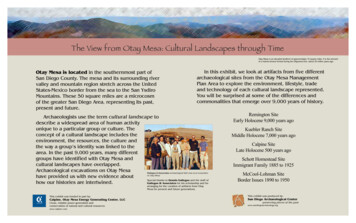
The View from Otay Mesa: Cultural Landscapes through TimeOtay Mesa is an elevated landform of approximately 15 square miles. It is the remnantof a marine terrace formed during the Oligocene Era—about 30 million years ago.Otay Mesa is located in the southernmost part ofSan Diego County. The mesa and its surrounding rivervalley and mountain region stretch across the UnitedStates-Mexico border from the sea to the San YsdiroMountains. These 50 square miles are a microcosmof the greater San Diego Area, representing its past,present and future.In this exhibit, we look at artifacts from five differentarchaeological sites from the Otay Mesa ManagementPlan Area to explore the environment, lifestyle, tradeand technology of each cultural landscape represented.You will be surprised at some of the differences andcommonalities that emerge over 9,000 years of history.Archaeologists use the term cultural landscape todescribe a widespread area of human activityunique to a particular group or culture. Theconcept of a cultural landscape includes theenvironment, the resources, the culture andthe way a group’s identity was linked to thearea. In the past 9,000 years, many differentgroups have identified with Otay Mesa andcultural landscapes have overlapped.Archaeological excavations on Otay MesaGallegos & Associates archaeological field crew at an excavationon Otay Mesahave provided us with new evidence aboutSpecial thanks to Dennis Gallegos and the staff ofhow our histories are intertwined.Gallegos & Associates for his scholarship and forRemington SiteEarly Holocene 9,000 years agoKuebler Ranch SiteMiddle Holocene 7,000 years agoCalpine SiteLate Holocene 500 years agoSchott Homestead SiteImmigrant Family 1885 to 1925McCool-Lohman SiteBorder Issues 1890 to 1950arranging for the curation of artifacts from OtayMesa for present and future generations.This exhibit was funded in part by:This exhibit was produced by:Calpine, Otay Mesa Energy Generating Center, LLCSan Diego Archaeological CenterClean, reliable power generation andconservation of natural and cultural mpreserving pieces of the past
The View from Otay Mesa: Remington Hills SiteEarly Holocene 9,000 Years AgoDuring the earlyHolocene (11,000 yearsago) Otay Mesa resembledthe Pacific Northwest. Awetter, cooler climate waspresent with an abundanceof plants and animals. Oak,spruce, cypress and pinethrived on the mesaTecate forest on Otay Mountaininterspersed with grassThe Climate of Otay Mesa during thelands. Plentiful waterEarly Holocene was cooler and wetterthan today. This surviving tecate forestallowed people to live thereis a remnant of the past environment.year-round.The Remington Hills Site is the oldest siteon Otay Mesa discovered thus far. Seashelldated using the radiocarbon method revealsthe site was occupied between 9,400 and7,000 years ago. Archaeologists label thisperiod Early Holocene or Archaic Period andthe artifacts the San Dieguito Tradition.We cannot know for sure how manypeople lived on Otay Mesa during the EarlyHolocene, but the number of artifacts indicatesthere were at least hundreds and possiblythousands. We have found no evidence of theirhouses, perhaps they were built of wood orplant material that disintegrated over time.About 20 to 100 people lived at this site atdifferent times, probably extended familygroups from one clan.The people living at the Remington HillsSite followed a hunting and gathering lifestyle.Over 2,400 pieces of animal bone were foundfrom rabbit, gopher and ground squirrel. Stonetools were tested for protein residue andrevealed that the menu included dog, rabbitand deer. Pollen from cattail, pine, oak, pricklypear, chia, blackberry, wild buckwheat,mustard and sunflowers was found at the site.Twenty different shellfish species are represented, including clam, mussel and oyster.There were plenty of resources at OtayMesa to provide a comfortable life, but there isevidence of trade with other regions. Obsidianflakes and tools were found at the site, tracedto the Coso formation in Inyo County over 300miles away. Coso obsidian was traded extensively during this period and has been found insites from San Francisco to Baja, California.Early Holocene scraper planesAlmost all of theartifacts found at theRemington Hills Sitewere made of stone.Without a doubt, therewere objects made ofbone, wood or leather,but these did not last inthe earth. The toolsStone Cores for tool makingSantiago Peak metavolcanic stone was found show a level of sophistion Otay Mesa and was popular for makingstone tools because it held a very sharp edge. cation that equals thetechnology of Stone-Agehunters in Europe. The preferred raw materialwas a fine-grained felsite called Santiago Peakmeta-volcanic stone. Otay Mesa contains thehighest concentration of this stone in SanDiego County. Several quarry sites have beenlocated on OtayMountain and OtayMesa, and there arelarge cobbleoutcroppings near theRemington Site.Archaeologistsfound domed scrapersArchaeology on Otay Mesaand large leaf-shapeIn 1998 TMP Homes began plans for a resipoints, effective toolsdential community in Otay Mesa. Adopting awestern theme, they named the developmentfor a hunting andRemington Hills with street names such asWyatt Earp. An Archaeolgoical excavation bygathering lifestyle.Gallegos & Associates done propr to construction resulted inthe discovery of the oldestknown site on Otay Mesa.These scrapers would have been much likea plane or adze for workingwith wood. They decrease in number over time as the trees start todisappear from the mesa when the climate changes.This exhibit was funded in part by:Calpine, Otay Mesa Energy Generating Center, LLCwww.calpine.comThis exhibit was produced by:San Diego Archaeological Centerwww.sandiegoarchaeology.org
The View from Otay Mesa: Kuebler Ranch SiteMiddle Holocene 7,000 Years AgoThe Kuebler Ranch Site was occupied about7,000 years ago, one of many sites from thistime period on Otay Mesa. Environmentalchanges were occurring on Otay Mesa duringthis time. The climate was warming and dryingout, although the Kuebler Ranch Site is closeto a perennial spring. Pine and spruce treesretreated to higher elevations, giving way tooak, coastal sage scrub and chaparral. The sealevel was rising, causing siltation in nearbylagoons. This provided mudflats for shellfishand habitat for water fowl.Some archaeologists believe that thegreater number of sites indicates from thistime period an influx of people during thistime. However, the Early and Middle Holoceneis viewed by many as a continual occupation ofthe same people adapting to environmentalchanges in the southern San Diego region.Their ingenuity in resource exploitation andmobility allowed them to successfully remainon the mesa even with profound climatechanges.Claude B. Kueblerpurchased land in OtayMesa in 1908 andestablished a horse ranchand raised cattle. Later, heplanted barley and an olivegrove. Kuebler continuedfarming into the 1920s andthe area became known asKuebler Ranch. In 1990 roadwidening near the ranch ledto the discovery andexcavation of an archaeological site from the MiddleHolocene period.The wide range of artifacts found at theKuebler Ranch Site reflect the varied needs of agroup of people living in the area for anextended period, or for repeated seasonalvisits. Once again, we have no evidence of theappearance of their homes, except for stonehearths. Milling stones and charred seedsindicate a growing reliance on plant foods.Small game, shellfish and fish made up the restof the diet. Large amounts of oak pollen foundin the soil of the site point to the acornbecoming an important food.The majority of artifacts found at theKuebler Site are made of stone, but a drilledscallop shell that once decorated a throatsurvived. Other examples of ornamentation areolivella shell beads, even though the site is 13miles from the ocean. Shells may have beentraded with other tribes in exchange for theCoso Range obsidian found at the site. Atourmaline crystal mined from local mountainscould have been a trade item as well.Santiago Peak veinOutcroppings of Santiago Peakmetavolcanic felsite are available onOtay Mesa. This hard, versatile stonewas favored during the Early andMiddle Holocene as raw material formaking stone tools.A large outcrop of Santiago Peakmetavolcanic stone was near the KueblerRanch Site, and was used to make spear anddart points. Scrapers were expedientlyproduced out of felsite or quartzite cobblesfound in stream beds. Punches and graversindicate that fine detailed work was producedon wood or bone, but those artifacts were lostto us over time.Middle Holocene toolsEvidence of Middle Holocene life survived better in the archaeological record, as there were more sites and they are younger. .Upper left: Scallop shell with drilled hole.Upper Right: Quickly made cutting tool of felsite.This exhibit was funded in part by:Calpine, Otay Mesa Energy Generating Center, LLCwww.calpine.comThis exhibit was produced by:San Diego Archaeological Centerwww.sandiegoarchaeology.org
The View from Otay Mesa: Calpine SiteLate Holocene 300 Years AgoBy 3,000 years ago, the climate at Otay Mesawas much like it is today, dry and warm. Thewarming conditions brought Yuman-speakingpeople into Southern California from thedesert areas to the east. Some of them settledin Otay Mesa, founding a large village complexalong the Otay River. The newcomers, the mostrecent ancestors of the Kumeyaay, broughtnew traditions and technologies with them.Many springs had dried up,although the Otay and Tijuanarivers still flowed year round.Pronghorn antelope, bighornsheep, deer and small game werestill common. The sea providedfish, rays, otters and seals. Anextensive range of plant foodswere used, with the acornbecoming a staple.The Otay River Valley wasdensely populated during the LateHand-held grinding stonesHolocene, with a handful of largeGrinding tools are very common inLate Holocene archaeological sites,year-round villages and smallerindicating a reliance on seeds andsatellite camps. We know fromacorns as an important food source.Spanish records houses weremade of bent poles tied at the top and coveredwith thatch and earth. Houses were arrangedin family groups based on male lineage, withthe father’s sons clustered around him.Villages were organized into bands ofrelated family members, which controlledspecific hunting and gathering areas. At thetime of European contact there were believedto be 10,000 to 20,000 Kumeyaay in about 50separate clans throughout the region.New technologiesare represented in theartifacts found at LateHolocene Sites. Potterysherds by the millionswere found. Pots wereimportant for storingfood, water and tradeitems. Tiny points madeof quartz, chert andobsidian were haftedonto arrows and shotwith a bow.Although mostPottery sherd with quartz arrowpoint.needs could be met onThe bow and arrow and pottery were importanttechnological aspects of life during the Late Holocene.the mesa, rare itemscould be obtained bytrade. Major trade routes existed between theColorado River and the coast. Coastal productssuch as abalone, salt, dried greens and fishwere traded inland for gourds, mesquite beansand agave. In addition to foodstuffs, steatite,obsidian, pigments, pottery, seashells, feathers,fur and dressed hides were traded along theseroutes.The establishment of permanent Spanishsettlements in San Diego would forever changelife in the Otay River Valley. Many of the Indianswere taken either willingly or forcibly to live atthe mission and the village complex at Otaywas abandoned shortly after the arrival of theSpanish. The village complex at Otay wasabandoned shortly after thearrival of the Spanish, the onlyevidence of this contact periodfound consists of a few glasstrade beads, no other artifacts ofEuropean origin were foundwithin the site. Those who did notgo to the mission most likelyscattered into the countryside tolive among their neighbors andfamilies in the mountains.Obsidian arrowpoints.There is no source of obsidian inSan Diego County . These pointswere made of obsidian broughtfrom the Obsidian Butte formationnear Salton Sea.Bedrock milling featureBedrock milling features are common at Late Holocenesites because acorns were a staple food.Excavation and curation of this Late Holocene site waspart of the mitigation undertaken by Calpine duringdevelopment of the Otay Mesa Energy GeneratingCenter. The facility will provide power on a 24-hour a daybasis to ensure maximum reliability and fuel efficiency.This exhibit was funded in part by:This exhibit was produced by:Calpine, Otay Mesa Energy Generating Center, LLCSan Diego Archaeological Centerwww.calpine.comwww.sandiegoarchaeology.org
The View from Otay Mesa: Schott HomesteadImmigrant Family 1885 to 1925Otay Mesa’s lush environment had given wayto chaparral and coastal sage scrub by thetime white settlers entered the area. Water wasbecoming scarce, as the Otay and Tijuanarivers provided only seasonal flow.The San Diego region experienced manychanges after California became a state in1850. Few of the Mexican ranchos remainedintact due to economic and legal challenges,and the land was made available to Americansarriving from the East. Because of the lack ofwater, Otay Mesa was one of the last areas tobe developed.Land promotion posterAfter the railroads reached California inthe 1870s, land promoters wasted notime in encouraging immigrants to cometo West. The city of San Diego wasexperiencing a population boom whenthe Schotts moved to the mesa in 1899.By the early 1890’s, over 40,000 peoplelived in the City of San Diego. Within adecade, however, San Diegoexperienced a bust and the populationfell to 16,000 in the city and 35,000countywide. When the Schotts left themesa in 1925, San Diego City had over75,000 residents with 113,000 spreadover the entire county.The Schott home was located on OtayMesa near the Otay River Valley. Twenty-eightfamilies lived on Otay Mesa then and manywere immigrants from Germany and Italy.From artifacts retrieved from the SchottHomestead Site, it appears that they were apractical people whose lives centered on thehome and farm. They lived in a simple woodframe house with a cellar for food storage.Three cisterns stored the precious commoditywater. Cooking was done on a wood/coalburning stove, in a house lit by kerosenelanterns. Carriages, wagons, and farmequipment were pulled by horses.The Schotts were resilient, resourceful andlived simply—a successful farming family. A fewcreature comforts were permitted: a bicycle forLulu and Ella had lovely dishes for the table.Much like the earliest residents of Otay Mesa,the Schotts did have to leave the mesa forsome material goods made elsewhere.Poster from Pictorial History of California, P.C. JohnsonIn 1899, a homestead certificate wasissued to Henry A. Schott, granting him 160acres of land on Otay Mesa. Census recordsreveal that both Henry Schott and his wife Ellawere born in Germany. Henry was 35 and Ellawas 29 when they arrived on Otay Mesa withtheir only child, Lulu, to start a farm.Dr. Fahrney & Sons Alpenkräuter-Blutbeleber, 1906-1930This patent medicine “Blood Panacea” was made in the United States,but sold under different names printed in other languanges to bemarketed to immigrant populations. The German translation indicates itis made from Alpine herbs for blood “animation.”Agriculture implements were purchasedfrom a catalog or bought in a neighboring city.The Levi Strauss jeans Mr. Schott wore(archaeologists found the rivets) would havebeen purchased on trips to town. It took nearlyfours hours to travel Otay Valley Road down themesa to San Diego.Farmers, such as the Schotts, located inrural Otay Mesa were instrumental in thedevelopment of San Diego County. Theyprovided food crops to feed a growingpopulation and business for local markets. Dryfarming techniques produced wheat, barley,corn, peaches, apricots, grapes, potatoes,beans and peas. The Schotts owned cattle andchickens, perhaps to provide a little extraincome from the sale of eggs and milk.A farming family’s luxury goodsLeft: Ella Schott set her table with flow blue dishes in the Davenport design made inEngland by Wood & Son, c. 1907.Right: Donkey charm, doll tea set saucer and bicycle pedal. The Schott’s only childLulu probably had farming chores, but also had toys to play with.This exhibit was funded in part by:Calpine, Otay Mesa Energy Generating Center, LLCwww.calpine.orgThis exhibit was produced by:San Diego Archaeological Centerwww.sandiegoarchaeology.org
The View from Otay Mesa: McCool-Lohman SiteBorder Issues 1890 to 1950The McCool-Lohman Site is located on OtayMesa south of Johnson Canyon, near the BajaCalifornia border. William and KatherineLohman bought the property in 1902, whichhad previously been farmed by the McCoolFamily. The Lohmans had come west fromMinnesota. The purchase of surroundingproperty brought the Lohman holdings on themesa to 880 acres. In addition to food crops,the Lohmans planted eucalyptus, palm, oliveand pepper trees. Families on the mesa wereencouraged to plant trees on their farmsteadsto delineate property lines, provide windbreaksand secure more land through the Timber Act.Chaparral and coastal sage scrubdominated the remaining uncultivatedlandscape of Otay Mesa at the turn of theCentury. Standing on Otay Mesa, one couldeasily see the Mexican city of Tijuana, foundedin 1917.Dr. Hood’s Sarsaparilla c. 1900Tonics made from the sarsaparillavine (a member of the lily family)were a popular patent remedy forskin diseases, rheumatism, syphilisand blood fortification. Usuallymixed with alcohol, its effectivenesswas probably questionable. Tonicsmade with alcohol were popularduring Prohibition because theywere lega. Just to clear up anyconfusion, sasparilla (a member ofthe ginseng family) is used to flavorthe more harmless rootbeer.During the late 1880’s San Diegoexperienced a great influx of people. Somewere illegal immigrants seeking economic relieffrom the poverty of Mexico, Asia and SouthernEurope.During Teddy Roosevelt’s presidency,“mounted inspectors” were hired to protect theboarder with Mexico. Initially, only 75 menwere hired, but the number was increased inresponse to the Mexican Civil War 1910-1920.With the passage of Prohibition, the San DiegoTijuana border became an easy way to smuggleliquor into the US. On May 28, 1924, an actestablished the Federal Services ProhibitionDetail, which later became the United StatesBorder Patrol in 1936.The first BorderPatrol agents wereselected from sheriffsdepartments and civilservice registers. Therewere no uniforms,officers were expected to Arnie and Annetta Lohman had enough incometo afford luxuries like this cameo glass candywear civilian clothing for dish and a turquoise pressed glass vase in theshape of a swan.the first couple ofmonths. Arnie Lohman, the youngest son of theLohman’s signed up. Arnie road the border onhorseback, looking for liquor smugglers.In 19--- Arnie married Annetta Waldrip, who hadbeen raised in Baja, California and spokeSpanish. From 1957 to 1974, Annetta servedas a part-time Customs Inspector at the Tijuanaand San Ysdiro border.Otay Mesa suffered from severe droughtduring the first two decades of the 20th Century.Dams built on the upper and lower Otay lakesdid not help with situation. The droughtprompted city fathers to hire a rainmaker, theinfamous Charles Hatfield. He may or may nothave caused the following deluge that causedthe Lower Otay Dam to overflow and burst,wiping out the town of Otay, killing 26 peopleand destroying the railroad. These hardshipsdrove most of the farm families off the mesa,and the rural communities on Otay Mesadisappeared.Vintage postcard of the San Diego-Tijuana Border c. 1920.This exhibit was funded in part by:This exhibit was produced by:Calpine, Otay Mesa Energy Generating Center, LLCSan Diego Archaeological Centerwww.calpine.orgwww.sandiegoarchaeology.org
The View from Otay MesaStone Tools: A Timeless TechnologyColors of Santiago Peak metavolcanic stoneStone Toolmaking on Otay MesaThe American Indian residents of Otay Mesamade sophisticated stone tools. It may bedifficult for us today to think of a rock as acutting tool, but stone was the hardestsubstance known to them. Stone tools start outas a core, a lump of raw material that looks likeit might flake or chip well. The qualities thetoolmakers looked for in a core were size and asmooth texture. A rock with inclusions or anuneven texture would not break where desired.Most stone tools from this region are madeby chipping a large flake off of a core and thenmodifying the flake to the desired shape andsharpness. Sometimes a flake could be usedas-is for a quick cutting job and then discarded.Flaking usually started with a stone hammerstone, then finer implements: bone, horn,wood and even fingernails for tiny serrationsalong the edge.From flake to pointStone tools started with a flake of raw material, furtherreduced to the desired shape.Drawing: Tracy Stropes, Gallegos & AssociatesSantiago Peak metavolcanic stone wasused by toolmakers extensively in the SanDiego Region. It was relatively plentiful, flakedpredictably and was very hard. Archaeologistsfind evidence of all stages of tool productionfrom cores, test flakes, finished tools anddebitage or waste flakes. Preforms, or toolblanks were made at quarry sites and takenback to the village to be finished later.Unfinished tools sometimes broke inunexpected ways, and one can almost feel thefrustration of the toolmaker as the pieces wereflung away.Obsidian: Trade and TravelObsidian is a naturally occurring volcanic glass.It was highly prized by ancient toolmakers forits ability to hold a very sharp edge. There is noknown source of obsidian in San Diego County,but obsidian flakes and tools were found onOtay Mesa. Where did it come from?Obsidian has a unique molecularsignature that can be matched withknown sources using x-ray spectrometry.Archaeologists discovered that theobsidian found in Early and MiddleHolocene sites on Otay Mesa was fromthe Coso Range, over 300 miles away. Obsidianfound in later sites was of a lesser quality andwas from Obsidian Butte in Salton Sea. Olivellashell beads may have been traded for obsidiancores with Indians to the northeast.Santiago Peak metavolcanic stone is a felsite thatis plentiful on Otay Mesa. The color ranges frompale sage green to almost black. It was popular asa raw material for stone tools because of itschipping qualities and ability to hold a sharp edge.Broken spear point, Early HoloceneThis incomplete spear point broke duringmanufacture and was found several feet apart atan archaeological site. It may have been thrownaway in frustration.Mima mounds on Otay Mesa c. 1920s, disturbed by agriculture and trailsThe residents of Otay Mesa must have wondered about the mysterious mounds dotting thelandscape. Called mima mounds, after the Mima Prairie in Washington State, they are lowlying mounds 10-20 feet across. Vernal pools formed between the mounds during the wetmonths, allowing specialized species of plants and animals to flourish. Archaeologists, aswell as geologists, have put forth numerous explanations for the presence of thesemounds. Ancient trees, seismic activity, even industrious gophers have been given creditfor the formations. Whatever the origin, the mima mounds provided yet another waterresource on the mesa for plants, animals and perhaps the earliest inhabitants of this area.This exhibit was funded in part by:This exhibit was produced by:Calpine, Otay Mesa Energy Generating Center, LLCSan Diego Archaeological Centerwww.calpine.orgwww.sandiegoarchaeology.org
The View from Otay Mesa: Remington Hills Site Early Holocene 9,000 Years Ago During the early Holocene (11,000 years ago) Otay Mesa resembled the Pacific Northwest. A wetter, cooler climate was present with an abundance of plants and animals. Oak, spruce, cypress and pine thrived on the mesa interspersed with grass-lands. Plentiful water