Transcription
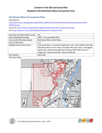
Content in the IDO and Comp PlanRelated to the Northwest Mesa Escarpment AreaNorthwest Mesa Escarpment PlanWeb ��REPEALED.pdfComp Plan: abc‐comprehensive‐planIDO: t‐ordinance‐idoJoint plan with Bernalillo CountyDate Adopted/AmendedCommunity Planning Area(s)Council District(s)Neighborhood AssociationsNA CoalitionPlan Area Map:Yes1987 / Last amended 2016Northwest Mesa, West Mesa1, 5Courtyards NA, La Cuentista Subdivision Unit 1 NA, Molten Rock NA,Montecito West Comm Assoc, Paradise Hills Civic Assoc, PetroglyphEstates NA, Piedras Marcadas NA, Richland Hills HOA, Santa FeVillage NA, Taylor Ranch NA, Volcano Cliffs NAWest SideCity of Albuquerque Planning Dept., April 1, 2020
Content in the IDO and Comp PlanRelated to the Northwest Mesa Escarpment AreaMain Purpose/Impetus of Plan: “ to continue implementation of adopted Albuquerque/BernalilloCounty Comprehensive Plan policies [including] the maintenance of the volcanic escarpment as openspace for public health, welfare and safety reasons, as well as to define the urban form and satisfyother open space needs. A plan incorporating policy and implementation is required to assurecompatibility of development and conservation with these policies.” (page 1)Yes* (page 41)Goals and PoliciesNoSU‐2 Zone DistrictsYes* (page 49)Zoning RegulationsCapital Projects/Implementation Yes (page 99)* Reflected in updated Comp Plan or Integrated Development Ordinance, see attached documentsCity of Albuquerque Planning Dept., April 1, 2020
NorthwestMesa678EscarpmentPlan1989The Following Nine Governing Concepts For Development AndConservation Are Established.a. The unique environmental, visual, recreational, archaeological andhistorical qualities and opportunities of the Escarpment are to beconserved.b. The escarpment area is recognized as a fragile and valuableenvironmental resource which harbors plant and wildlife within aunique geologic formation. Disturbances to the natural environment,in particular to the drainage, basaltic caprock, slopes and vegetationcould result in erosion and caving of slopes and boulders and pose athreat to the public safety and welfare by impacting existing andfuture downstream and downslope development.c. The escarpment is to be conserved as an entire unit with arecognizable relationship to the volcanoes which created it, the mesatop which borders it, and the arroyos which bisect it.d. The black escarpment face is recognized as giving physical order tothe community and as acting as a visual reference point. Views to itand from it are recognized as important.e. The archaeological/historical resources are recognized asinexorably 1 inked to their setting. The resources and the settingmust always be considered in relationship to each other as well as toother influences.Page 1 of e CountResilience & SustainabilityInfrastructure, CommunityFacilities & ServicesHeritage ConservationParks & Open SpaceHousingEconomic DevelopmentUrban DesignPolicyTransportationPlanCategory/Section Topic(in plan)Land UseNo.LastAmendedCommunity IdentitySECTOR PLAN POLICIES ADOPTED IN THE COMPREHENSIVE PLAN5REVISED 3/31/2020
esa682EscarpmentPlanf. The natural setting and archaeological/historical resources of theescarpment combine to provide recreational and educationalopportunities which are to be developed in ways which will notdamage either the setting or the resource. Management andmaintenance are recognized as intrinsic needs.g. The escarpment is not an isolated portion of the community. It isrecognized as physically, culturally and economically integral to therest of the community and as providing physical, cultural andeconomic benefit to the community.h. Conservation of the escarpment rock art, and relatedarchaeological sites allows for further research and discoveries of thepeople who inhabited the Middle Rio Grande Valley. The art is notonly an artistic expression of the prehistoric peoples, but is a recordof their culture and history. The physical and historical connectionfrom the mesa to the valley through an open space network willcreate significant educational, research and recreationalopportunities.i. The escarpment's archaeological/historical resources are recognizedas important to the world as well as the local community. Thebenefits of having the resource in our community carries with it acorresponding responsibility to the larger world community.1989198919891989Archaeological sites shall be identified and protected or mitigated, asConservation Area & appropriate.Impact AreaAny damage to the vegetation, slope, or placement of boulders dueConservation Area & to or related to construction shall be mitigated.Impact AreaConservation Area &Impact AreaStructures shall not block views of the escarpment or visually contrastwith the natural environment.Page 2 of 5Reference CountResilience & SustainabilityInfrastructure, CommunityFacilities & ServicesHeritage ConservationParks & Open SpaceHousingEconomic DevelopmentUrban DesignPolicyTransportationPlanCategory/Section Topic(in plan)Land UseNo.LastAmendedCommunity IdentitySECTOR PLAN POLICIES ADOPTED IN THE COMPREHENSIVE ,11.3.4.f5REVISED 3/31/2020
1989Sites which cannot be set aside as open space, including recreationalfacilities,and sites adjacent to open space, shall have minimum visualConservation Area &impact.Impact AreaNo structure shall be placed within 50 feet of the top or the base ofthe escarpment face. No irrigation systems or construction oralteration of the natural terrain shall occur within 30 feet of the topor base of the escarpment face. Fences will be allowed no closer toConservation Area & the escarpment face than 30 feet. Any construction within theImpact Areaconservation area must be certified geotechnically sound by the cityengineer, so as not to cause a threat to the public safety. (seeregulation 22‐8, page 84, for possible exceptions.)Public access and public facilities shall be compatible with thesensitive nature of the escarpment. Public access shall be at pointswhich are least sensitive to use, whenever possible. Utilities androads shall be limited to areas which are least sensitive toConservation Area & disturbance. Areas to be avoided, if at all possible, are PiedrasMarcadas Canyon, the point where the middle branch of the SanImpact AreaAntonio crosses the escarpment, the marsh peninsula, RinconadaCanyon, the escarpment south of Rinconada Canyon and PetroglyphPark.Unser Boulevard shall be designed to minimize its impact along theConservation Area & length of the escarpment.Impact AreaThe following design regulations are adopted for the Paseo Del NorteConservation Area & crossing of the escarpment, per UTPPB R‐87‐12:Impact AreaThe city shall recommend to the bikeways committee and the urbantransportation policy planning board that the bike trail on top of themesa from Rinconada Canyon to Paseo Del Volcan be deleted fromConservation Area & the Bikeways Master Plan as a proposed bike trail. ComprehensiveImpact Arearecreational trail planning will be conducted for the entire plan area,at which time alternative bike trails will be considered.Page 3 of 57.6.3.b10.3.5.c,10.3.5.eReference CountResilience & SustainabilityInfrastructure, CommunityFacilities & ServicesHeritage ConservationParks & Open SpaceHousingEconomic DevelopmentUrban DesignPolicyTransportationPlanCategory/Section Topic(in plan)Land UseNo.LastAmendedCommunity IdentitySECTOR PLAN POLICIES ADOPTED IN THE COMPREHENSIVE PLAN11.3.4.f,11.3.4.g211.3.4112.1.14000REVISED 3/31/2020
rpmentPlan1989198919891989198919891989Drainage facilities' design shall be sensitive to the character of theexisting escarpment. Arroyo corridor and drainage managementConservation Area &plans are the appropriate planning level for specific channelImpact Areatreatment recommendations for arroyos identified in the "FacilityPlan for Arroyos".Resource AreasView Area RegulationsView Area RegulationsResource AreasResource AreasResource Areas12.1.4.b,12.4.4Four Areas, including The Escarpment and surrounding lands, areestablished for different degrees of conservation as shown on maps10 and 2: the escarpment face, the conservation area, the impactarea and the view area.The city shall review the implementation of this plan twenty‐fourmonths after the date of its adoption to analyze progress. At thattime, the boundaries of the conservation area will be reassessed inlight of fiscal capabilities.* This has substantially been addressed through Open Space landacquisition and through IDO regulations for Avoidance of SensitiveLands.Page 4 of 55.6.1Reference CountResilience & .1,10.3.511.3.1,11.3.4,11.3.4.1,11.4.57Structures above and below the escarpment shall not dominate theviews of the escarpment from the east side.The escarpment face shall be kept open and undeveloped, consistentwith the Comprehensive Plan and the Rank 2 plans for the NorthwestMesa.* This has been addressed through Open Space land acquisition andthrough IDO regulations for Avoidance of Sensitive Lands.211.3.1,11.3.4.cThe predominant colors used on structures within the view area shallblend with the natural colors of the mesa.The city desires to protect the conservation area from development.It shall make every effort, with assistance from the federal and stategovernments, to acquire portions for open space park purposes andprotect the remainder through the development process.* This has substantially been addressed through Open Space landacquisition and through new IDO zoning protections in the NorthwestMesa View Protection Overlay and Avoidance of Sensitive Landsregulations.Infrastructure, CommunityFacilities & ServicesHeritage ConservationParks & Open SpaceHousingEconomic DevelopmentUrban DesignPolicyTransportationPlanCategory/Section Topic(in plan)Land UseNo.LastAmendedCommunity IdentitySECTOR PLAN POLICIES ADOPTED IN THE COMPREHENSIVE PLAN0REVISED 3/31/2020
esa699EscarpmentPlan1989198919891989Reference CountInfrastructure, CommunityFacilities & ServicesHeritage ConservationResilience & Sustainability1211.3.4.37.3.1Page 5 of 5Parks & Open Space10.3.5.a,10.3.5.bWithin the design overlay zone, adequate information to enablereviewing agencies to determine compliance with design regulationsshall be required. Requirements of the design overlay zone,Design Overlay Zone appropriate to the stage of approval, must be met prior to approvalof rank 3 plans, land division, site development plans, facility designsand building permits.Design Overlay ZoneHousing11.3.4.1For property within the city of Albuquerque and Bernalillo County, adesign overlay zone is established which covers the conservationarea, the impact area and the view area as shown on map 10. Alldevelopment within the design overlay zone shall comply with thedesign regulations of this chapter. Variances other than thosespecifically allowed for in this plan constitute plan amendments andDesign Overlay Zone must follow the standard plan amendment procedure. A request foramendment to the plan may be processed simultaneously with arequest for site plan approval. Site plan approval by either the City orCounty Planning Commission shall be conditional on plan amendmentapproval by the City Council and the Board of County Commissioners.Development at the edge of public or private open space shall bedesigned to complement and enhance the open space.Economic DevelopmentResource AreasWhen the boundaries of the conservation area are reassessed, theconservation area will be designated a historic overlay zone pursuantto the state historic districts and landmarks act and the citylandmarks and urban conservation ordinance.Urban DesignPolicyTransportationPlanCategory/Section Topic(in plan)Land UseNo.LastAmendedCommunity IdentitySECTOR PLAN POLICIES ADOPTED IN THE COMPREHENSIVE PLAN11REVISED 3/31/2020
SECTOR PLAN REGULATIONS ADOPTED IN THE IDONorthwest Mesa Escarpment PlanSOURCEAdopted Plan or RegulationNorthwest Mesa Escarpment PlanNorthwest Mesa Escarpment PlanLOCATION IN EFFECTIVE IDO - 5/17/2018AreaNorthwest MesaEscarpmentVPO-2Northwest MesaEscarpmentVPO-2ChapterZone DistrictAdministration andEnforcementSection NameSection Ref.PageView Protection Overlay Zone3-6(E)124Variance - EPC6-6(M)410Source: IDO Effective �Effective‐2018‐05‐17.pdfSee also: IDO Effective Draft, Footnoted ft‐2018‐05‐17‐wCover.pdfPage 1 of 1REVISED 3/31/2020
blend with the natural colors of the mesa. 11.3.1.c 1 692 Northwest Mesa Escarpment Plan 1989 View Area Regulations Structures above and below the escarpment shall not dominate the views of the escarpment from the east side. 11.3.1.c, 11.3.1.d, 11.3.1.1, 11.3.4.f 4 693 Northwest Mesa Escarpment Plan