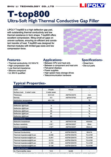
Transcription
THERMAL ANOMALIES AROUND SALTRESEARCH CONSORTIUMResearch ProposalThermal Impacts of Salt on Source Rocks and Reservoirs in the Paradox Basin, Utah, theWestern Pyrenees, Spain and previously collected samples from La Popa basin, MexicoSubmitted To Industry by:University of Nevada Las Vegas, Dept. of Geoscience4505 S. Maryland ParkwayLas Vegas, NV 89154-4010Principle Investigator: Dr. Andrew D. HansonProposed Duration: 2 yearsStarting Date: Fall, 2011 Ending Date: Fall, 2013Cost Per Continuing Company: 20,000 (i.e., 10,000/year)Cost for First-Time Members: 22,000 ( 12,000 for the first year, and 10,000/yr thereafter)TABLE OF CONTENTSExecutive Summary - p. 2Research ProposalObjectives of Consortium ---------------------------------- p. 5Geologic Setting of the Field Areas ---------------------- p. 9Significance - p. 12Deliverables - p. 13Collaborative Nature of this Consortium -------------- p. ---------------- p. 15Appendix1. Research Personnel --------------------------------------- p. 19
2THERMAL IMPACTS OF SALTRESEARCH CONSORTIUM(2011-2013)EXECUTIVE SUMMARYThermal Impacts of Salt on Source Rocks and Reservoirs in the Paradox Basin, Utah, theWestern Pyrenees, Spain and previously collected samples from La Popa basin, MexicoA Research Proposal Submitted by Dr. Andrew D. HansonDepartment of Geoscience, University of Nevada Las Vegas,Las Vegas, NV 89154-4010Because salt is two to four times more thermally conductive than other sedimentary rocks thepresence of salt within a basin has a major impact on heat flow within the basin. Outcrop studies,linked with subsurface data, of salt diapirs and welds provide the best datasets for examining theimpacts of the high thermal conductivity of salt upon adjacent strata because of access (incontrast, wells adjacent to salt provide limited spatial access, and seismic does not resolve smallscale features that can be seen at the outcrop). Understanding the thermal impact of salt is vitalfor understanding source rock maturity, calculations of hydrocarbon volumes, loss of reservoirquality at shallow depths and reservoir preservation at unusually deep levels and is important withregards to hydrocarbon migration associated with salt structures. All of these issues impact saltrelated play concepts and reservoir scale geologic models. The Paradox basin (UT, USA) and theBasque-Cantabrian region (Western Pyrenees, Spain) contain exceptional exposures of a varietyof types of salt diapirs, salt welds, salt walls and mini-basins where the scale and geometry offeatures created by salt-sediment thermal interactions can be examined in plan view. Recentlyacquired seismic data from the Pyrenees, along with planned acquisition of seismic data from theParadox basin, together with our new outcrop data are shedding insights into the importance ofheat flow associated with salt structures. The salt and salt-related structures in these basinsprovide high-quality, accessible exposures that are uncommon in the world, but which providethe only “ground truth” data that can be used to define and calibrate the presence, scale andimportance of thermal impacts related to the salt.This proposal seeks funding for the ongoing Thermal Anomalies Around Salt ResearchConsortium. The consortium is a research effort that expands and explores important issues that
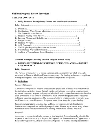
3other ongoing consortia studies have not addressed. An initial “proof of concept” project jointlyfunded by the Salt-Sediment Interaction Consortium (SSC) at New Mexico State University andExxonMobil Exploration Corporation led to the establishment of our consortium last year and thisproposal seeks funding that will allow us to build on conclusions from the initial work, to focusresearch efforts on specific aspects of each objective listed later in this proposal and to testmodels and concepts that are spelled out in later sections of this proposal. The initial researchrevealed significant thermal anomalies associated with a subaerial diapir (see Fig. 1 for aschematic representation of the results) and our efforts last year significantly expanded the typesof features we have researched. This consortium works collaboratively with the SSC, whichfocuses on sediment response and structural issues in salt basins, but differs from it in that wefocus on thermal issues, hydrocarbon migration and basin modeling related to salt. We also haveexcellent connections with the Basin and Petroleum System Modeling (BPSM) consortium atStanford University.The objectives of this consortium are to: 1) document the variability in thermal historiesadjacent to different types of diapirs, welds, walls and mini-basins and determine the controls onthat variation, 2) document the impact of varying thermal histories within single reservoirsadjacent to salt with regards to preservation/destruction of reservoir quality, 3) document theimpact on thermal maturities associated with different structural levels of salt structures, 4)document the thermal variability associated with different types of salt bodies, 5) characterize thenature of fluid flow associated with salt features, and 6) link the results of outcrop studies tosubsurface data and model the results with the intention of reducing uncertainty with regards tohow hydrocarbon migration occurs next to salt strucutres.The annual fee for subscription to the Thermal Aspects of Salt Research Consortium is 22,000 for a two-year period (2011-2013). Annual deliverables will be produced based on thetotal level of funding available and will include as many of the following as funding allows:(1) A yearly formal meeting, in which research results from the past year are presented. Thevenue for the second meeting will likely be in Moab, UT in early fall 2012, or in Las Vegas,NV or Houston, TX in late fall 2012.The research results meeting may (depending on annual meeting location) be followed by:(2) Participation of up to three of your company’s employees on a 1 day, post-annual meetingfield trip to view features of the salt basins. The fieldtrip will showcase features related to thethermal impact of the salt on adjacent sediments. The field trip will include a guidebookcontaining maps, cross sections, field and laboratory photographs, and other data setscompiled as part of this research.
Ro 0.85Ro 1.0Ro 1.45salt withdrawalminibasinSaltRo 0.5Ro 0.85Ro 0.7Figure 1 Schematic representation of variability in vitrinite reflectance seen in the “proof of concept”study completed by Hanson.
5(3) Availability of digital research database upon request.(4) Preprints of all publications and theses.(5) Access to a password protected website, which has all research publications and guidebooksavailable to download.6) An annual CD containing all publications, abstracts, theses, and research completed duringthe year.7) Qualification for private, custom designed fieldtrips for your company lead by the PI to eitherthe Paradox basin or the western Pyrenees.Basic funding for the initial “proof of concept” and/or the first year of the consortium wasprovided by Anadarko Petroleum Corp., BP America Production Company, ChevronTexacoExploration and Production Company, Devon Energy Production Company, ExxonMobilExploration, Hess Corp., Marathon Oil Company, Nexen Petroleum U.S.A., Samson OffshoreCompany, Shell Offshore Inc., StatoilHydro, and Total E&P Research & Technology USA, LLC,with additional financial support provided by ExxonMobil Upstream Research.In order to join the consortium, please contact Dr. Andrew Hanson (Andrew.hanson@unlv.edu)and we will provide a standardized agreement for your company to sign. Companies that electednot to join during the first year will be allowed to do so and will be given all previously generatedknowledge and materials but will pay a slightly higher rate their first year in the consortium.Should your company decide to leave the consortium it may do so by providing 30 days notice. Insuch an event no refunds of contributions will be provided.
6RESEARCH PROPOSALThermal Impacts of Salt on Source Rocks and Reservoirs in the Paradox Basin, Utah, theWestern Pyrenees, Spain and previously collected samples from La Popa basin, MexicoThe Paradox Basin of eastern Utah and the Basque-Cantabrian Region of the western Pyrenees inSpain provide excellent outcrop analogues for salt features known primarily from seismic andwell data of subsurface salt basins. Deposition of sediment in these basins is linked to saltmovement and subsequent uplift and erosion has resulted in exposed salt diapirs, welds, salt wallsand mini-basins. At these localities the scale and geometry of salt structures is beautifullyexposed at the outcrop. Given that there are very few examples of these types of outcropexposures anywhere on the globe, these features provide exceptional opportunities to understandhow thermal conductivity impacts maturation and reservoir preservation/destruction. Byconstraining how sediments adjacent to these structures are impacted by the salts thermalconductivity we will be able to test, calibrate, and create new models of the thermal controls onsediments adjacent to salt structures. The resulting models and calibrations will provide important3-D constraints for wells being actively drilled within salt basins globally. This proposal seekscontinued industry funding for research to document the timing and scale of thermal impactsassociated with diapiric rise and evacuation of evaporite masses in the Paradox Basin, Utah andthe Basque-Cantabrian Region of the western Pyrenees in Spain. Ongoing research on reservoiranalogue samples previously collected from La Popa basin, northeastern, Mexico will alsocomprise part of the future research this consortium will conduct. No travel or work will becompleted in Mexico: instead we will use samples collected in Mexico in 2008.OBJECTIVES OF PHASE IIThe proposed Phase II research will focus on 5 fundamental objectives. Each of the objectives isbriefly summarized below and major conclusions drawn from previous studies are articulated. Wethen specifically address the new direction the proposed research will take as it pertains to thatobjective. We will collect new field data from appropriate areas in the the Paradox and Pyreneesbasins (and possibly the Flinders Range in Southern Australia) and combine it with availablesubsurface data in order to test hypotheses and meet the following objectives:
7Objective 1Continue to document the variability in thermal histories adjacent to different types of diapirs,welds, and mini-basins and determine the controls on that variation.Questions for Phase II:1) To date we have documented both hot and cold anomalies associated with one of thediapirs we have worked on. At two other diapirs we see suppressed paleo-temperatures innear-diapir areas. Our preferred approach is to sample from a single stratigraphic layerthat intersects the salt structure. This approach eliminates lateral variability in paleothermal maximum data (i.e., our vitrinite data) due to different burial histories. It alsoallows us to determine whether there is lateral variability in the strata we sample. Weassume that uplift, erosion and subaerial exposure occur instantaneously (in geologicterms) so we rule out lateral variability related to weathering effects. Our overall goal isto determine how much, and what type of variability is produced by temperature regimesthat existed adjacent to the salt (e.g., diapirs, walls) or salt related structures (e.g., welds).2) The diapir we studied that has both hot and cold anomalies has always been assumed tobe sub-vertical. Does the presence of hot and cold anomalies on opposite sides of thediapir suggest that the diapir is actually tilted and that the anomalies are linked to suprasalt and sub-salt positions? If so, are classic halokinetic sequences, which are welldeveloped along one margin of a nearby diapir, actually sub-salt features instead of beingfeatures that develop off the sides of vertical diapirs? We are currently awaitinganalytical results from a second locality that exposes strata that previously sat in supraand sub-salt positions.3) Does the size of a salt structure impact the scale of the thermal anomaly? Our firstresearch was adjacent to a relatively small diapir but our research over the past year hasexpanded the scope of our project and increased the size of our dataset. We hope todocument the variability of thermal anomalies and determine if these anomalies are scaledependent? Do large welds have larger anomalies than a small diapir? Do salt walls havethermal anomalies that are of a different scale than those around diapirs? Modeling byPetersen and Lerche (1995) suggested that the temperature gradient associated with saltcan be felt out to about 1-1.5 times the salt width, but both our initial results and our newresults from the past year contradict their predictions.Objective 2Document and model the impact of elevated and depressed thermal maturities on preservationof reservoir quality and source rock maturation.Questions for Phase II:1) We want to continue to document and understand how vitrinite values vary around singlediapirs and other structures. Our pilot study showed that temperatures at two points onopposite sides of the diapir were vastly different but we do not know how temperaturesvaried around the diapir.2) Are elevated vitrinite values due to salt conductivity? Or are they controlled by migrationof fluids derived from deeper in the basin? Or are they related to conductive cells thatdevelop above salt? We have samples that can be examined to start to address thesequestions and we hope to analyze them in the coming year(s).3) How have the different thermal histories we’ve documented adjacent to the studieddiapirs impacted reservoir quality and source rock maturation? Quartz cementation islargely controlled by temperature so there should be a direct relationship between the
8thermal histories we are recording and the amount of cementation but this has not beenconstrained. We will point-count samples from sandstones in salt basins and analyzetheir chemistry in the UNLV SEM and Microprobe labs in order to determinecementation histories and see if these two phenomena are linked, as we suspect. Ifcementation varies within reservoirs adjacent to salt structures, how does that variabilityimpact hydrocarbon migration into the reservoir? Our plans to constrain the cementationhistories as well as our plans to model these systems should help shed new light on theseissues.4) Around diapirs with different paleo-temperatures, are pores in sandstones adjacent to thediapir more completely cemented on the side of the diapir where higherpaleotemperatures were recorded? Conversely, are sandstones adjacent to the diapir lesswell cemented in the area where lower paleotemperatures were present? These issueshave important implications for exploration teams that are targeting reservoirs near saltsturctures.5) Is the scale of a thermal anomaly significant with regards to thermal maturation of asource rock in the basin? If so, how would these impact calculations of hydrocarbonvolumetrics within a basin model? It seems intuitive that thermal conductivity in lowpermeability organic-rich shales (i.e., source rocks) will be vastly different than it is inadjacent porous/permeable reservoirs sandstones. By comparing how large the lateralthermal anomalies in the shales are (i.e., our vitrinite data) versus the lateral anomalies inthe sandstones (i.e., our cementation/diagenesis data) we can start to model these unitswith reasonable temperature values.6) Can we reduce uncertainties regarding hydrocarbon migration around salt structures byincorporating the thermal data into basin models? We will construct 2D basin modelsusing either BMod or Petromod that tie our surface data to available subsurface data (i.e.,seismic, well data).Objective 3Document the impact on thermal maturities associated with different structural levels of saltstructures.Questions for Phase II:1) Does structural level control the type of anomaly (i.e., are all shallow near-salt sedimentsanomalously hot whereas deep structural levels are anomalously cold) as modeled byPetersen and Lerche (1995)? If so this has important implications on reservoirpreservation adjacent to salt bodies at great depths as well as on source rock maturationadjacent to salt. Modeling by Yu et al. (1992) suggested that at deep structural levels thedifference in temperature between a point within the salt and a point within the adjacentsediments at the same depth could be as great as 50oC but no “ground truthing” hasconfirmed the validity of this work. We have a relatively small, but growing data set, ofvitrinite values from rocks that range in age from Miocene to Cretaceous that haveexperienced different depths of burial whose vitrinite values range from a low of 0.35 toas high as 1.86 %Ro. As our dataset continues to expand we should be able to answerthese questions.2) Modeling (Mello et al., 1995) suggests that temperatures in sediments that surround thetop of a diapir will be elevated. Modeling and limited well data (Vizgirda et al., 1985)also suggest that sediments adjacent to the lower portions of diapirs will be colderbecause of the “wicking” of heat out of the sediments because of their proximity to thesalt body. By testing anomalies in different basins that have been exposed at differentlevels we will be able to address these questions. As Petersen and Lerche (1995) pointed
9out this may mean that a potential source rock that is overmature in the adjacent basinmay still be in the oil window adjacent to the salt structure.Objective 4Determine the viability of using biomarker maturity parameters and apatite fission trackanalysis (AFTA) to assess thermal anomalies in Precambrian-Cambrian strata in the FlindersRange of Australia where different types of allochthonous salt bodies (subhorizontal saltextrusions and salt canopies) crop out.Questions for Phase II:1) Can we use these techniques to document and quantify thermal anomalies adjacent to saltstructures in pre-Silurian rocks? We assume we can, and using these techniques we canexpand our research on thermal anomalies to areas where the strata do not contain vitrinite(e.g., the late Precambrian-Cambrian Flinders Range of South Australia which containssignificantly more types of salt structures than the other research areas)?2) We have used biomarker maturity parameters in the past and know we can effectively usethem in pre-Silurian rocks, but the analyses are costly. Hanson was essentially co-advised byProfessor Mike Moldowan at Stanford and continues to work closely with him in hisbiomarker lab. Can we secure adequate funding in order to use these methodologies?Objective 5Characterize the nature and timing of fluid flow at the salt sediment interface.Questions for Phase II:1) We (Hudson and Hanson, 2010) previously documented evidence of hydrocarbon migrationadjacent to the weld in La Popa basin. We will map in the vicinity of the salt structures wetarget in order to document potential hydrocarbon migration sites and pathways, with specificfocuses on locations displaying discoloration and remineralization as well as waxy-appearingsoils that smell like hydrocarbons. TOC, Rock-Eval and conventional biomarker analyseswill be utilized to determine the presence of migrated hydrocarbons. Is there evidence ofhydrocarbon migration at our other study sites?2) Is there a preferred fluid migration pathway and entrapment stratigraphy related to halokineticsequence types? Our previous work (Hudson and Hanson, 2010) indicates that migratedhydrocarbons do not ubiquitously occur in all areas along the weld in La Popa basin, butrather are confined to certain localities. We hope to document additional migratedhydrocarbons adjacent to diapirs and refine our understanding of where migratedhydrocarbons occur. The results will be compared to the known halokinetic sequences and wewill be able to address the relationship between fluid migration pathways and halokineticsequence boundaries and facies.
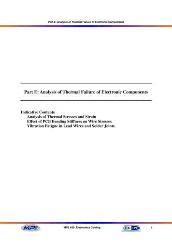
10Geologic Setting of the Research Field AreasGeologic Setting of the Paradox Basin, Utah and ColoradoThe middle Pennsylvanian Paradox basin of eastern Utah and western Colorado developedsouthwest of the NW-trending Uncompahgre uplift (Fig. 2; Baker et al., 1933; Wengerd andStrickland, 1954; Elston et al., 1962). Thick cycles of Pennsylvanian shale, dolostone, halite andother salt minerals make up the Paradox Formation and define the limits of the basin (Petersonand Hite, 1969; Condon, 1997). Overlying the Paradox Formation are Pennsylvanian and Permiansiliciclastic strata that fine upward and change facies to the southwest. These changes createdcomplex facies and the resulting stratigraphic nomenclature is complex (Baars, 1961; Condon,1997). Northwest-southeast oriented elongate salt walls that are the result of PennsylvanianJurassic diapirism are characterized by thickening of strata into elongate minibasins between thesalt walls (Shoemaker et al., 1958, Doelling, 1988; Trudgill et al., 2004).The Pennsylvanian-Permian Cutler Group consists of arkosic alluvial deposits that are up to 5 kmthick next to the Uncompahgre uplift. These proximal facies grade into a thick section of cyclicmiddle Pennsylvanian evaporite, shale and carbonate of the Paradox Formation, Honaker TrailFm, and Lower Cutler Beds to the southwest (Barbeau, 2003). Marine, eolian, fluvial siliciclasticand minor carbonate members of the Cutler Group (Halgaito Fm, Cedar Mesa Fm, Organ RockFm, and White Rim Sandstone ) in the southeastern and medial portion of the Paradox Basininterfinger with the alluvial deposits of the upper portion of the Cutler Fm deposited near theUncompahgre uplift (Condon, 1997). Unconformably overlying the Cutler Group is the LowerTriassic Moenkopi Formation, which was also derived from the Uncompahgre uplift. TheMoenkopi postdated important shortening-related flexural subsidence (Barbeau, 2003) butrecords continued diapirism in the salt anticline region in the NE part of the Paradox basin(Shoemaker et al., 1958; Shoemaker and Newman, 1959; Trudgill et al., 2004). Dolostone andgypsum clasts derived from salt walls that were exposed during the Early Triassic have beendocumented in the Moenkopi (Lawton and Buck, 2006).Salt walls in the northeastern part of the basin trend NW-SE and extend from Oligoceneintrusions in the La Sal Mountains to the southeast to a plunge termination at the Colorado Riveron the northwest. Gypsum, black shale and dolostone of the Paradox Formation crop out locallyon the flanks and near the middle of the eroded salt wall and are well exposed adjacent to theOnion Creek diapir. Permian through Jurassic strata thin towards the salt walls and dip steeplyaway from the salt walls and are even overturned near salt walls. Unconformity bound halokinetic
GJ110o WGRGreenUn109 o VDlCoGV 38oNExplanationParadox BasinSalt wallParadox Fm.pC basement120o110 o100 o90 o80o70oEdge ofPennsylvanian saltSananJuUtah40 oUSAR.Map locationUtahColorado37oN30o0100 kmFigure 2 Map of salt walls in the Paradox Basin in Utah and Colorado,U.S.A. Towns include: GR Green River, GJ Grand Junction; andM Moab. Salt walls include: ST Salt Valley; FV Fisher Valley; MSV Moab-Spanish Valley; CV Castle Valley; SV Sinbad Valley; PV Paradox Valley; LVD Lisbon Valley-Dolores; GV Gypsum Valley.Figure is from Lawton and Buck (2006).
12sequences are defined by abrupt dip changes across bed boundaries in Cutler and Moenkopi beds.Lawton and Buck (2006) documented the Castle Valley weld in the Castle Valley area and strataappropriate for thermal anomaly studies crop out adjacent to the weld. We have initiated studiesin both Onion Creek and Castle Valley.Geologic Setting of the Basque-Cantabrian Region, Western Pyrenees, SpainThe opening of the North Atlantic margin resulted in deposition of Late Triassic evaporites in thearea that would later become the western Pyrenees (Canérot et al., 2005). In the western Pyreneesalternative extension and shortening controlled the location and style of salt structures. Salt-coredanticlines initially formed above WNW-ESE trending basement faults (Fig. 3). Northeastsouthwest oriented Aptian-Albian transtension subsequently caused salt domes to be exposed atthe surface at the intersection of the earlier salt walls and the younger transtensional faults (Fig.3). Some of these diapirs underwent dissolution post-Late Cretaceous and are filled with youngerstrata but as many as 20 different diapiric structures have been mapped in the region (Canérot etal., 2005). Geologic maps of the western Pyrenees (1:25,000 scale) available from Ente Vasco dela Energía revealed that lithologies adjacent to the diapirs are amenable to thermal anomalystudies and we have conducted field work adjacent to three of these structures. The abundanceand distribution of diapirs in the region (some areas contain 6-7 diapirs separated by about 25km)make it ideal for understanding how anomalies would be expressed in areas with a high density ofdiapirs. Because of the regional structure (less eroded and deformed to the south and westcompared to deeper structural levels to the north and east) this area may also provide insights intohow anomalies vary as a function of structural depth.Geologic setting of La Popa basin(site where sandstone samples collected in 2008, which we will analyze as reservoir analogueswere derived)La Popa Basin, northeastern MexicoLa Popa basin lies within the Late Cretaceous to Paleogene Hidalgoan/Laramide foreland systemnear the city on Monterrey in northeastern Mexico (Fig. 4). Mesozoic through Eocene strata in LaPopa basin are deformed by northwest-southeast trending folds of the Coahuila marginal fold belt(Wall et al., 1961; Fig. 5).La Popa basin contains an estimated 7.5km of Lower Cretaceous through Eocene strata(Fig. 6)(Hudson and Hanson, 2010). The bulk of the exposed strata consist of the Parras Shale
4o W2o WATLANTIC OCEANSanSebastianBiscBilboa43 o NAntic l iFranceSpainneCinco VillasMassifSynclineAitzgorriAnticlinAralar A.eAlvaerFRANCEllasAn ticlin eEbroRivePaleozoicOverthrustAnticlineFault025 miSynclineDiapir040 kmSPAINNEsteMontes-Obarenea Sy n cli n eDiapi rM i ra n dPoza De La SalMap Areanenclia SysabrUic ZoneEbro RivCantabrianRangesayaGuernicaVillasana De MenaArnorFig. 3 Map of western Pyrenees showing location of multiple diapirs (from Canérot et al., 2005).
T exasCoahuilaNSabinas28 ldFolaui ltah BeCoMonclovaCPLP26 TorreonPBMonterreySaltillo102 Sierra MadreOriental100 Figure 4 Map (above) showing the location of La Popa location map shown below(taken from Giles and Lawton, 1999).
Geologic MapofLa Popa basinCarroza FormationTvViento FormationAdjuntas FormationTaKpaTvKpcTplpJmLPDelgoKplLaKpsjSan Jose lentilLower Gordo oteKpglKiJmEP3828Tpu403670Km Muerto FormationKpa10KplCuchilla Sandstone KpdKlLower Potrerillos FormationKpsjmeasuredsection 30La Popaweld4976KmadNorth Chivos lentil*TvKpd Delgado Sandstone MemberKplKiA'Tc35KpcUpper Gordo lentilTpcKpaSan Josede la PopaLa Popa lentilTpguKplKmTpu Upper Potrerillos FormationTplpKmKplTpuExplanationTcKpdTpcTv26o 15' NKpKpcEscondidaParras ShaleIndidura FormationLower Cretaceous lentilsJmEGKpaTvTa15CarrizosKpKpl682326o 00' NTpgl2732Lower Cretaceous limestoneJurassic evaporiteTpu34TpuKpdMap Symbols32Km32Strike and dip ofbeddingDelgado32Kpl40LaKpl25Photogeologic bedviaGaAnticline25 12Ki19Syncline,showing plunge30El Milagro10FaultKmParraskm101o 00' W50Reverse fault, teethon hanging wallBasinKplLa Popa basinA'N SWSLa GaviaanticlineMeters1000DelgadosynclineTpu TaNEEl Gordodiapir KpglTvKmSSWNNEEl JmJu-KlKplKpaKmENEKmKiKpaTvTaKmWSWLa Popaweld Tplp KpsjKplKpl0-1000Salt weld100o 45' WAParras 000Principal detachment-800001234 kmFigure 5. Geologic map and cross section of La Popa basin (taken from Giles andLawton, 1999).
La PopabasinAgeSierra MadreForelandSabinasbasinTexas GulfcoastUpperMudstoneLower 3membersMuertoRanchonuevoParrasIndiduraCuesta del DuraB la CarrozaLa PenaB la CarrozaEarlyCupiditoCupidoBarremianHauterivian ownUpper AcatitaTamaulipasAuroraLa PenaLa rassicKimmeridgianMenchacaLaCasitaUpper SigoLa CajaLa CasitaSchulerBossierZuloagaMinas ViejasCallovianLa agaLouannWernerBajocianLa BocaAalenianEarlyPearsailKnowlesTaraisesOxfordian Minas ViejasBathonianGlen RoseLaCupidoSigoVirgen CupidoLowerTamaulipasSan MarcosHosstonTaraisesLa CasitaFredricksburg/Stuart CityCupiditoCarboneraRedbedsTaylorUpsonIndiduraL & M El ToroTithonianNavarrothermal uronian Upper El ToroCretaceousCerro GrandoTulolmagenesCerro Huesta SanMiguelParrasSantonianConiacianMidwayLas nateMarine ss, shale/Marine shaledelta frontBasinalcarbonateEvaporiteFigure 6. Stratigraphy of La Popa basin and adjacent areas (taken from Giles and Lawton, 1999).Diapirism in the La Popa basinUpper ssHidalgoanshorteningWilcoxrift extensionCampanianMaastrichtianAdjuntasCotton bsidenceMELateJacksonCarrozaDiffunta GroupPotrerillosEoceneL
17and the Difunta Group, which range in age from Late Cretaceous (Campanian) to Eocene. TheParras Shale (Campanian) is less than 1200 m in La Popa basin and underlies the
University of Nevada Las Vegas, Dept. of Geoscience 4505 S. Maryland Parkway Las Vegas, NV 89154-4010 Principle Investigator: Dr. Andrew D. Hanson Proposed Duration: 2 years Starting Date: Fall, 2011 Ending Date: Fall, 2013 Cost Per Continuing Company: 20,000 (i.e., 10,000/year)