Transcription
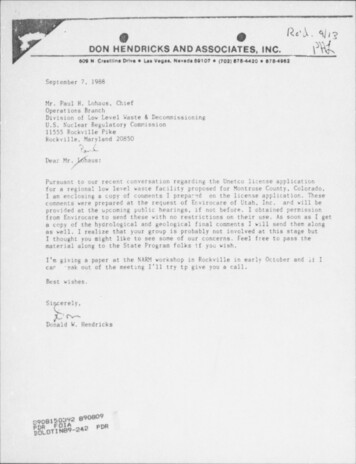
- - - - ,.1,'.,, ''.'*;pgC'DON HENDRICKS AND ASSOCIATES, INC.;h)}.ik609 N. Creatiltse Drive e Las Vegas, Nevada 89107 e (702) 878-4420 e 878-4962;1September 7,1988Mr. Paul H. Lohaus, ChiefOperations BranchDivision of Low Level Waste & DecommissioningU.S. Nuclear Regulatory Commission11555 Rockville PikeRockville, Maryland 20850fdDear Mr.aus:. Pursuant to our recent conversation regarding the Umetco license applicationfor a regional low level waste facility proposed for Montrose County, Colorado,I am enclosing a copy of coraments I prepared on the license application. Thesecomments were prepared at the request of Envirocare of Utah, Inc. and will beprovided at the upcoming public hearings, if not before. I obtained permissionfrom Envirocare to send these with no restrictions on their use. As soon as I geta copy of the hydrological and geological final comments I will send them alongas well. I realize that your group is probably not involved at this stage butI thought you might like to see some of our concerns. Feel free to pass thematerial along to the State Program folks if you wish.I'm giving a paper at the NARM workshop in Rockville in early October and li I.can ' eak out of the meeting I'll try tp give you a call.Best wishes,.Si erely,pMDonald W. Hendricks1,c908150392 890009LL -- -OT-242PDR,i.
- - .,t.'Ccement s on Proposed Umeteo Recional Low-Level Radioact ive Waste Disposal Facilit y,GeneralReview of the documents provided by Umetco to substantiate its license applicationfor a proposed Regional Low-Level Radioactive Waste Disposal Facility indicates anumber of disturbing facts. Some of the areas of concern are:1. Most of the data being put forth as pre-operational environmental monitoringdata was collected in the 1981-1982 time frame as pre-operational data for aproposed uranium mill tailings and effluent impoundment. The impoundment was tobe located in the Uravan area but not at the presently proposed Regional Facilitysite. Since most of this data was not collected on (or for) the Regional Facility,its value in assessing the Regional Facility is questionable. Basically little ordescribing on-site geology, hydrclog), or background radiationdatalevels (such as external gamma radiation or radioactivity in soil or vegetation)r.ohas been provided.D2. The 1981-1982 information which has been provided in the license applicationsuggests strongly that at distances from Uravan greater than the proposed Tecilitylocation the soil surf ace appears to have been contaminated by vindblevn tailingsf rom past milling operations. Apparently substantiating this conclusion, airborneradionuclides concentrations at all locations reported ranged f rom a few timesexpected background (on an annual average) to a hundred or more times backgrour.dat some locations. Soil levels seem to increase toward Uravan which suggests thata large area may be contaminated by past millings operations at the Umetco Uravanto levels requiring cleanup. Based on the limited data provided, the areamillpossibly requiring cleanup could include the area proposed for the Regional Facility.3. k* hen siting a radioactive waste f acility (or other nuclear facility), such asthe Regional Facility, it is customary to perform pre-operational environmentalmonitoring studies. These studies are carried out over at least a one year periodto establish a pre-operational environmental background, including a radiationbackground. In this case, little or no information has been gathered directly ator on the proposed site. little or no information has been gathered in the pastsix years, and the information being put forth was collected for a different facility:fat a different location. The data provided is very confusing and gives the appearanceof a cut and paste job. For instance, Site A or Site B in one document are not thesame f,ite A or Site B shown in a second document. In cddition to multiple Sites Aand B there are also Stations A and B. The proposeo project site shown on maps insome documents is not the same site as the proposed project site shown in theApplication volume. The data which has been provided suggests problems with theproposed Facility site.j) )lIf a f acility does not have a good set of background (pre-operational) data,then f acility operators and regulators can not determine how well the facilityis performing in meeting release standards. If the facility has an unusually highpre-operational background, then small, or perhaps even large, facility releasesof radioactivity can pass undetected. Additional on-site soil samples should becollected on-site at the propo ed Regional Facility location to assess the soilbackground levels. Long term air sampling suf ficient for good statistics should becarried out to determine if airborne levels have dropped as a result of Uravanreclamation operations. - --
- - - - -.- -,n;--3.4. Studies carried out by the Colorado Geological Survey (CGS) as a regional searchfor areas that appeared to be suitable for the disposal and long term containmentof low-level radioactive wastes identified six candidate ar -as in Colorado. Noneof these areas were in the Uravan area. After a followup study, requested by theColorado Department of Health (apparently at Ucetco's request), the CGS identifiedfour potentially suitable sites in the Uravan area as possible disposal sites forDenver radium wastes. The proposed Facility site is not one of the four consideredsites. In fact, the CGS Task A report refers to the f act that permeable zones found1in the Brushy Basin Member of the Morrison Formation could seriously reduce thesuitability of a site as a vaste repository. The proposed Rim Site would be locatedin the Brushy Basin member, no subsurf ace exploratory work has been performed atthe site (or at least not reported), but the Colorado Department of Health has givenpreliminary approval to the License Application ared proposed site. Similarly theEast btnch Site is ti be located in the Salt Vssh Member which in Appendix /. isreported as an aquifer in the Spring Creek area.In its Task B report the CGS evaluated and ranked potential disposal sites. Theproposed site was not considered. Of the six sites in Montrose County, none of thesites were in the top ten of the Colorado sites considered geologically acceptable.The Task B report concludes that, while a da spcsal site meeting the minimumgerlogical and peotechnical criteria could with reasonable probability be foundin the l'ravan (Club Mesa) area, it was not likely that the site would comparef avorably with other more suitable sites elsewhere in the state. The main reasonfor locating a disposal site in Mont' rose County seemed to be "socio-political"acceptance. It is unfortunate that political acceptance should supersede safetyand conta:nment.5. The CGS Vestern Montrose County Low-Level Vaste Site Reconnaissance reportalso addressed the issue of transportation safety. It properly pointed outthat "The single lane nature of all access routes into vestern Montrose Countyand their sometimes steep and tortuous nature would increase the number and, probably,the ses erity of traf fic accident s.". What the report does not point out is theincreased possibility of a transportation accident scattering radioactive dirtwith resultant soil, air, and possibly water contamination along the transportationccrridors. Considering the large number of heavy truck shipments which would haveto be made daily over a two year or longer period the risk of multiple accidentswould appear high.6. Design of the East Bench impoundment appears to be inadequate in a number ofrespects. As shown in Figures 2.3-2 and 2.3-3 the clay liner does not completelysurround the waste materials. In particult.r. there appears to be no clay If nerover the ring dike which can provide a large area radon exhalation. pathway for radonthe wastes, especially since the dike can contain rocks up to 36 inches1eavingin diameter. The proposed use of vegetative cover is surprising since it is genera *,1yregarded as a mistake to grow vegetation on radioactive vaste tailings piles. Mar.yplants, especially desert plants, can root up to 25 feet or more. The vegetaticaover time not only attracts burrowing rodents but over time transports r 4vectivityto the surface of the pile . Burrowing rodents also transport vastes to the surface.Figure 2.9-4 (Appendix A) shows a large prairie dog town in the middle of the East ,!Bench Site.-- - - - - - .3{l I
.*yw'.e-3.,6. (Cont.) . The depth of . cover and quality of cover meterials appears minimal.Since little on-site exploratory ' work appears to have been conducted. t wouldseem uncertain whether adequate cover materials can be found as projected.It is also disturbing that if (or more likely . when) cracks are found in thebedrock below the impoundment, there seems to .be no criteria which says that if-cracks are above a certain sizo the site is not suitable. According to page 2-51if such cracks are found the rock will either be further excavated or coveredwith granular material. Since such cracks provide pathways for seepage and transportof' radionuclides, it would seem that criteria are needed to limit the size anddensity of cracks.Is.e- mm. . . . m m. .- . . . . . . ,- - - . . . . .
- - - .L'l.',.'Aypendix AComment s on Proposed Umetco Rerional Low-level Radioactive Weste Disposal Facilit sAir Samplinn Calculat ionsThe 1981 soil sampling results listed in Table 4.1-20 of the Umetco LicenseApplication show that at distances of 2-3 miles from Uravan mill site, radioactivityin soil levels begin to drop to near background. In this case background app,arsto be about 1 picocurie per gram (pC 3/g) for radium-226 and uranium. Thorium-230-levels remain elevated above expected background at almost all sampling locations.Essentially all' of. the. sampling locations are well beyond both the proposedEast Bench and Rim Sites with respect to the former Uravan town site.However, this soil sampling data als'o shows that the pre-uranium milling backgroundin soil over the proposed Regional Duposal Facility Site has apparently beenincreased to 10-20 (or more) times tne original background, probably by millingactivities since the thoriw 230 elevated levels are indicative of finer fromwindblown tailings. Since chain radionuclides are out of equilibrium and uranium isBenerally low with respect to the other radionuclides. ore outcrops do not appearto be the cause of the elevated thorium and radium. This data would suggest thata large area around the uravan town site may be contaminated to levels requiringcleanup under EPA cleanup criteria. This contaminated area would appear tc includethe proposed Regional Disposal Far.ility.The above conclusions appear to be confirrad by the air sampling data presentedin Tables 4.1-1 through 4.1-3. Section 3.2.7.3 shows annual geometric means(1981-1982) for Total Suspended Particulate (TSP) at four sites on Spring CreelMesa and one site in Uravan. These means r,nge from 13.9 to 29.8 micrograms perc ubi c met er . L's d r:c a value of 20 rr.icrogran. per cubic meter for an average ! ?concentration on Sprint Creek Mesa ond a soil background level of I pC3 /g forradium-226 (or other uranium chain radionuclides), an expected backgroundairconcentration can be calculated:20 f g1 pC.xp,610 pgm g20 x 10-6 pC 3 2 x 10⁻⁵ pC3,33,Air sampling results in section 4.1.1.1 and in Tables 4.1.1 - 4.1.3 are reportedin units of pC /,3 . 'Ihis is equivalent to:31 (C3 / ,3 (C/,33x610 pC/pC33 10Radium-226 concentrations (annual) averaged 0.5 x 10'O6pCg / ,3.KC/,3 for the six3stations or :0.5 x 10⁴ p Cg / ,364x 10 pC/fCg 0.5 x 10³pCg /,3ora f actor of about 40,000 belov expected background.!,
-. - - - -,t".2-. 3t would appear that'.the correct air sample measurement units should bereported as' microcuries per cubic centimeter instead of microcuries per cubicmeter.If correct, making this change.vould give an average radium-226. concentration of:.,0'30.5 x.10-15 hC3 /cc x 10 cc/m50 x 10-3 pC /m 3;3 Assurring the correct units arex610 pC 3/pC 3 0.5 x 10⁻³ pC /m 33ior25 times the expected background.FC3 /cc, the ranges of' measured annual'mean.airborne concentrations at the six stations aretjIredaue-226 4.9 x 10to 120 x 10-5 pC3 /m3 -( 2.5 to 60 x bkg) .21 x l'0-5 t o 370 x 10 -5 pC,/m3 ( 10 to 185 x bkg)-thorium-230 l'- r.a .61 x 10-5 t o 610 x 10-5 pC3 /m3 (30 to 300 x bkgl.-Er.thly max 2mem values an , 2n some cases, as much as a factor of 10 above theannual ceans.If microcuries per cubic meter are the correct units, then the reported values. would see- to. be physically impossible. ., . . . . .-
.'.Specific Comeents' on Umetco DocumentsApplication for Radioactive Material License1. Cover pace. Item 6a.It is not clear why the license application 25 notfor both Phase I and Phase II. The application appears to be an attempt toget a license for the East Bench Site but to postpone indefinitely anyapplication for the Rim Site. It is also not obvious why the applicant did!not relect a site where both kinds of wastes could be' disposed of in nearsurf ace f acilities. Part 61 of the U.S. Nuclear Regulatory Commssion Regulatior.contains specific technical requirements for near surface (upper 30 meters)disposal of radioactive vaste. As of February 29, 1988, technical requirementsfor alternative disposal methods such as tunnels have not been published.In view of this, the proposed Rim Site design may not be acceptable, if andwhen technical requirements are finally published.2. Executive Sungary. 2nd page. 1st para. Part 61.12 requires that thespecific technical information to be provided :aust inc3ude " geologic, geotechnihydrologic, meteorologic, climatologic, and biotic features of the disposalsite and vicinity." (Emphasis added.) Since the environmental data in AppendixA of the Application was gathered in the 1981-1982 time frame, and was not, witrminor exceptions gathered at either the Rim S'te or the East Bench Site, itwould not appear to meet the requirements of Part 61.3. Executive Summary. 2nd page.1,st para. The application appears to be anattempt to get a 31canse for the East Bench Site which shculd make money forthe applicant but to postpone at least indefinitely any application for the-Rim Site shich will probably 16se money. Underground mining tends to be muchmore expensive than near surface dirt moving. Since it may not be economicto develop the Rim. Site , what then happens to the compact wastes? When willthe decision be made to proceed with the Rim Site or to reject it? If the RimSite is not e:cnomically feasible or can not qualify under Part 61 (which isa real possibility) , will Umetco then place the Compact wastes with the Den *.erRadium wastes in the East Bench site, in a separate above ground repositorywithin the proposed Regional Facility, or will Utetco simply return the compactwaste disposal problem to the State of Colorado.4. Executive Senmarv. 3rd pace. 1st para. It is dif ficult to see how theState of Colorado could have given preliminary approval for a site whichenvironmental data onneither the State or the applicant owns, for whichthe site has not been gathered, and for which environmental data gatheredin the vicinity indicates that the site is contaminated with the same radionuc1that are to be buried.5. Page 2-5. Figure 2.1-4. Figure refers to Figures 2.1-5 and 2.1-6 shich aremissing from the application.6. Page 2-6, 1 st pa ra . Phase I .should ar o include the 12 month pre-operationa:environmental monitorin g program mandated by Part 61 or the equivalent Stateof Colorado regulations.- 1i!ill{-- - - -
.- - - . ,,.-2-,.,17. Pate'2-7, 3rd para. Since no subsurface exploration has been conducted atthe East Bench site, will any exploration be conducted before vastes are emplaced?It;looks like Umetco simply plans to start construction and emplace:ent ofwastes without any studies actually on the site. As a minimum , the degree ofexisting contamination by mill tailings should be evaluated before dirt movingstarts. Also, are there mineral resources under either site?' '8. Pane 2-7. Items 1 and 2. There are also criteria for external ganma exposurerates and radium in soil levels. Data provided with this application is notadequate to determine whether these criteria can be met presently before thevaste arrives.9.Page2-8,-lostpara. Sincetheenvirobmentalstudieswerenotconductedatthe Rim or East Bench sites they support the application only in a very-limitedLway. In fact, soil ar.d air sampling data collected elsewhere on che Mesa suggestthat both sites may be contaminated w th the very radionuclides that will beburied at East Bench. The archaeological survey is not obviously relevant toeither site since Appendix A indicates that mest of the survey was conductedabove 5,750 feet except near the Spring Creek Truck Trail. Information providedin the Appendix is inadequate to evaluate whether the East Bench and Rim sitesspecifically were studied. The East Bench site is below 5,400 feet while theRim site portal and support f acilities appear from the sketch to be below 5,750feet, This section and elsewhere are misicading in that the Spring Creek Mesa Site referred to is neither the fast Bench site or the Rim site but ratherthe Uravan tailings disposal site which is some distance away. While ambientlevels of radiation' vere indeed measured they do not appear to have been backgroundlevels.10. Page 2-22. 2.2.1.5. .Since the East Bench site drains to the San MiguelRiver on almost a 360 degree basis, it seems like a poor choice of places tolocate the waste storage site since any seepage or accident will move towardthe river.11. Pace 2-26. Last para."The Salt Vash beneath the East Bench Site is mo;tlikely dry." Since subsurface exploration has not been performed at the sitewhat happens if the Salt Wash is not "most likely dry"? If not dry, is thatgrounds for rejecting the site? Will the dryness even be investigated if wasteis ar riving in late fall 1988?12. Paee 2-27.1st para. If the Salt Wash "Immediately southwest of the DisposalFacility" is saturated with leakage from the tailings piles, how close isimmediately southwest? No maps are given to -how this relationship.13. Page 2-27. 3rd para. Since no subsurface exploration has been done on siteat either the East Bench site or; the Rim siJe. how is it known that theBarro Canyon is not saturated within the Disposal Facility? Since the Rim sitewill be located in both the Brushy Basin and the Burro Canyon, it vould seemthat on site test drilling should be done before starting construction.- - - - - - - - - - - - --
e 1 -.-3-G''i14. Pane 2-34. Item 8. The Task B criteria address ecologic resources anonot economic resources. The size of the East Bench site may not be adequateif the volume of Denver Radium wastes has been underestimated as may easilybe the case. It is fairly common to underestimate the volume of earth to beremoved because of recontamination problems during cleanup. Construction ofanother dike or extension of the proposed impoundment would require mo"inginto either the drainage channels or the drainage basins. Since the in.,)undmentis presumably being designed for 200,000 cubic yards what would the design beif the volume were 50-100% larger?,,3".L15. Page 2-34. 2nd para. There are only 11 fatal flaw criteria- not 12. Sincethe Colorado Geological Survey did not evaluate the East Bench or Rim siteswho made the comparison which decided the sites passed all eleven criteria?Is there some reason CGS did not evaluate the East Bench or Rim sites?-.16. Page 2-34. 3rd para. Same comment as 15 above. An 11 out of 30 rankingmakes one wonder why none of the top 10 sites were chosen.'17. Pace 2-35. Since there has been essentially no on site subsurface investigationhow are the answers known to factors 2,3,6,12,13,.and 14? Is this a Umetco ranking?18. Page 2-36, 1st para. While perhaps not directly applicable to the proposedEast Bench site, the fact that Spring Creek Mesa was rejected in the previousevaluation of siting alternatives certainly makes it of interest particularlyif the evaluationrelated to such things as seepage, hydrology, geology, etc.419. FiRure2.3-1. The area shown as the interim storage area on this map seemsto also be located in the middle of the proposed drainage channel shown onFigure 2.3-5.20. Ficure2.3-2. Since the clayey liner does not extend under the cover itwould be expected to provide a radon seepage path through the non-clay region.21. Figure 2.3-3,, There seems to be no attempt to provide a complete clay seelaround the vastes to contain radon. As designed the complete ring dike wouldappear to provide a radon seepage path particularly with boulders up to 36 inchesin diameter in the dike. The choice of a vegetative support layer is surprisir.gto say the least. It is commonly accepted that growing vegetation on tailingspiles enccurages burrowing rodents, can pull radon out of the pile, and cantranslocate radioactive wastes to the surface via the root system. In this lightFigure 2.9-4 of Apnandix A shows a prairie dog town in what appears to be themiddle of the East det. h site. An explanation should be given for this design.While the choice o' a s'.te may dictate the need for a ring dike, it should notdictate the design of the cover. The cover generally appears inadequate. Whilethe average radium concentration of the Denverradium vastes is reported as173 picocuries per gram , maximum values ranged to over 5,000 picocuries per gram.If the higher level vastes wind up near the surface, the cover thicknesses may]not adequately attenuate radon releases.,ti! )-- - - - -- - - - - - - - - -
g- .-4--&'[f' .22. Figure 2.3-3. Random fill would better be changed to clay while the riprapthickness appears totally inadequate. Design of UMTRAP reclamation sites shouldbe considered in this design.23. Page 2-45, 2.3.1.1.6. The interim stomge area is outside the fenced area(see Figure 2.3-1). Is the site to be guarded on weekends and holidays?24. Page 2-46. 6th para. At what point during construction is the pond insidethe repository removed? The construction sequence is not clear. Is the completering dike constructed before the vastes are placed inside or only partiallyconstructed in which case what prevents the vastes from washing doen the hillin a rainstorm?25 Figue 2.3-4. What is done with the vaste water from the wheel wash facility?26. Page 2-51.1st para. Six inch diameter' material seems like large. material.to be using to fill cracks and to provide a base for the clay liner.27. Page 2-51. 3rd para. At 25-35 gallons of water per cubic yard 'of materialthe repository vill contain at least 5-10 million ga'11ons of added water (ormore) before burial is completed. This seems to be a high final water contentwhich may contribute to seepage.L28."Page 2-60.- last pa-a. and pane 2-61. The calculated air sampling resulto aretwo orders of magnitude below the expected air sampling results and two ordersof magnitude above the reported measured results. (See general comments.) Thelevels at Nucla seem high considering the distance from the facility.29. Page 2-77. 3rd para. See comment 21 above.30. Page 2-74 When will this monitoring program start? Monitoring locations arenot shown on Figure 2.4-1. A legible single map is needed which shows allmonitoring stations for both the Uravan Reclamation and the Regional Facility.31Pane' 2-78. The high moisture content probably brings down the radon emanationrate and hence lowers the thickness of required cover. If the clays dry andishrink or crack more cover may be n'aeded. 32. Page 3-4. Item 7. Since subsurface investigations were not conducted at theEast Bench or Rim sites and urar.ium and vanadium are in economically significantquantities in the Salt Wash Member, how is it determined that such reserves arenot under eithe r site before construction starts?33. Page 3-6.3.2.7.1.1.Temperatures do not seem to make sense.34. Pane 3-7.3.2.7.2. Wind rose is not shown in application. Unless weatherstation was at the East Bench site, data collected on the mesa top is going tobe 'at least somewhet different than the actual situation at East Bench. I'IL - - - - -:;-
h--. .!-5- *-.35. Page 3-18 and Page 4-63.Preoperational direct radiation measurements areusually not reported to four signicant figures when made with an instrumentthat is good to 10-20 %.36. Page 4-1. 4.1.1.1.37. Pages 4-36 and 4 .37.See Seneral comments.k' hat are units on sediment samples?.O-.
location the soil surf ace appears to have been contaminated by vindblevn tailings f rom past milling operations. Apparently substantiating this conclusion, airborne radionuclides concentrations at all locations reported ranged f rom a few times expected background (on an annual average) to a hundred or more times backgrour.d at some locations.