Transcription
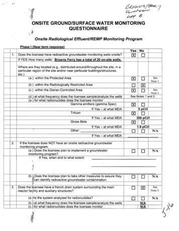
ONSITE GROUND/SURFACE WATER MONITORINGQUESTIONNAIREOnsite RadiologicalEffluent/REMP Monitoring ProgramPhase I (Near term response)1.Does the licensee have radioactive groundwater monitoring wells onsite?Yes0NoE1If YES: How many wells: Browns Ferry has a total of 20 on-site wells.Where are they located (e.g., distributed around/throughout the site, in aparticular region of the site and/or near particular buildings/structures,etc.)(a.) within the Protected Area[]El(b.) within the Radiologically Restricted AreaE][](c.) within the Owner-Controlled Area00SeeNote 1.SeeNote 2.(d.) at what frequency does the licensee sample/analyze the wells(e.) for what radionuclides does the licensee monitorGamma emitters (gamma Spec)See Notes 1 and 2.[jIf Yes - at what MDATritium5 Ci/I[]If Yes - at what MDAGross BetaIE300 pCi/I[] I]If Yes - at what MDAOther:U1.9 pCi/II N/A] ]If Yes - at what MDA2.If the licensee does NOT have an onsite radioactive groundwatermonitoring program:(a.) Does the licensee plan to implement a groundwatermonitoring program?.If Yes, when and to what extent:3.(b.).Does the licensee plan to take other measures to assure theycan identify radioactive groundwater contaminationDoes the licensee have a french drain system surrounding the mainreactor facility and auxiliary structures?(a.)rs the system analyzed for radionuclides?(b.):at what frequency does the licensee sample/analyze the wells(c.)'for what radionuclides does the licensee monitor11-1AýF]E]N/A-N/Ar-U[SeeNote 3.]N/AN/AN/A' 5;
IiIfYes-atwhat MDAIII1I JTritiumIf Yes - at whatI-Gross BetaIf Yes - at what4.MDAMDADoes the licensee have a surveillance program to periodically:(a.) walk'down outside areas around the site to look for potential leaksand Spills?(b.) prespbrize buried radwaste lines to evaluate structural integrity and,evaluate potential for leaks and spills?[E]-Ir 5.Does the licensee perform any other onsite monitoring (e.g. soilsampling) to identify unexpected radioactive releasesE]F]6.Does the libensee's radioactive liquid discharge line traverse any nonlicensee owned areas (e.g., it is on a right-of-way surrounded by privateproperties)?E][]7.If the licensee has a discharge pipe that runs underground or anyundergrou'nd piping that carries radioactive liquids, does the licenseeperform monitoring along the discharge pathway to identify potentialleakage. If YES,Yes[]NoElHow frequently is the sampling performed: Wells R-1, R-2, R-3 are sampled quarterly. See Note 4Phase II(Longcer Term Response)Yes8.Historical' ,Qnsite Radioactive Contamination:(a.) Does'the licensee have any history of radioactive spills and/or leaksoutside f buildings/structures?Are ttey documented in 10 CFR 50.75g file?(b.) Hasg"the licensee identified onsite radioactive groundwatercontamination?NoMjXI0--]SeeNote 5.SeeNote5.El
If YES:When was it identified - IF known:Dates: See Note 6.LER/Abnormal Event Report/Condition Report Nos:See Notes 6 & 7. (If available)0To what extent - IF known [square footage, estimated ground depth of thecontamination, estimated quantity (volume / concentration), etc.]See Note 6.Has the contamination moved outside theRestricted Area or the owner-controlled area4E]0SeeNote 7.
A,9.Comments;:Note 1:' There are 4 wells (Well 6 and Wells R-l, R-2, R-3) within the Protected Area. SeeFigure 1. iWell 6 is the only REMP on-site groundwater monitoring location. Well 6 issampled by an automatic sampler (a composite of daily aliquots with samples taken foranalysi- eyery 4 weeks). This monthly sample is analyzed by gamma spectroscopy and aquarterlyromposite is prepared and analyzed for tritium. Samples from Wells R-1, R-2, andR-3 arecýole cted quarterly and analyzed for tritium and gamma emitters.Note 2: There are 16 wells (Wells 1,2,3,4,5 and Wells L8 through L18) located outside of theProtected Area but within the Owner-Controlled Area. See Figure 2. Wells L8 through L18(which are located surrounding the Low Level Radwaste (LLRW) Storage Area on the eastside of the Owner-Controlled Area) are sampled annually and are analyzed for tritium, grossbeta, and gamma emitters. Wells 1,2,3,4,5 are, not routinely sampled.Note 3: Browns Ferry does not have a French-drain type system. However, Browns Ferryhas used a dewatering system in which the groundwater near the building structures wasremoved. This dewatering system has been abandoned in place and is no longer operated(and, therefore, is not monitored) due to concerns that, over a very long period of time,removing this water might adversely affect the building structures.Note 4: Wells R-1, R-2, R-3 were installed in 2000 in response to a ANI concern based onindustry operating experience regarding leaking radwaste discharge piping. These threeshallow wells were installed in the vicinity of the radwaste discharge piping specifically tomonitor any possible leakage.Note 5: The extent of the current abnormal contamination issues at Browns Ferry are asfollows: (1) the R-3 Well Tritium (Only) Contamination, (2) the Turbine Building-to-IntakeCable Tunnel Contamination and (3) the ADHR Soil Contamination. The need to documentthese peri0 CFR 50.75(g) has been identified in the site corrective action program (PERs96105, 96242, 99273). The site corrective action program (called eCAP) is considered thesite's 10CbFR 50.75(g) file.Note 6: The R-3 Well Tritium Contamination is the only Browns Ferry radioactivegroundwater contamination identified. Low-level tritium contamination was first identified inthe R-3 VWell in early 2001 following initial installation of these wells in September 2000. SeeNote 4. PER 96105 has been written due to this condition. This groundwater does notpresent an unmonitored pathway to a drinking water supply and the maximum tritiumconcentration result (792 pCi/I) is less than 5% of EPA drinking water standard (20,000 pCi/I)and is less than 0.01% of the 1OCFR20 Appendix B limit (10 ECLs for tritium is 1.OE-02 uCi/mlor 1.OE407 pCi/I). The R-3 Well is considered a shallow well and is approximately 18 feetdeep. An accurate estimate of the extent of the area or volume of soil affected is not known.The last' smple obtained from the R-3 Well (on 02/24/06), the tritium concentration was MDA ( 300 pCi/l).Note 7: .FSAR Section 2.4.2.1.2, Hydrology - Site Area, states "Natural ground watermovement in the area is from the plant site to the Tennessee River." Related to the R-3 Well,the groundwater movement would likely be to the forebay, into the CCWPs and discharged tothe river or would follow the CCW conduits (externally) to the river. The first downstreamdrinking water river intake is monitored through the BFN REMP. (The nearest river waterintake for. drinking water is approximately 7 miles downstream.)
Note 7: (continued)The Annual Land Use Survey indicates there are no privategroundwater wells located within one mile of the site perimeter (onthe north side of the river). Public water supplies are used in theselocations.For the R-3 Well, the radwaste discharge piping appears to be themost likely source since, in general, the tritium tends to trend withwhether liquid radwaste discharges are occurring or not (i.e.generally decreasing from 2001 to mid-2003 with no liquid radwastedischarges and generally increasing since resumption of liquidradwaste discharges from mid-2003 until present). Given the mostlikely source is from Radwaste (possibly from the BF-2/3 radwastedischarge lines into the CCW), at this time, the present condition isnot considered reportable since any tritium released from Radwastehas been accounted for and reported in ODCM monitored andapprovedreleases. The apparent leakage is delayed (slower) in itsdischarge to river than that calculated for Radwaste radioactivereleases and are, therefore, considered bounded by the currentODCM radwaste release methodology.Fy,Yes No1.Does the licensee have radioactive groundwater monitoring wells onsite?If YES: HOw many wells: Browns Ferry has a total of 20 on-site wells.Where are they located (e.g., distributed around/throughout the site, in aparticular region of the site and/or near particular buildings/structures,etc.)(a.), within the Protected Area0SeeNote 1.(b.) within the Radiologically Restricted Area(c). within the Owner-Controlled AreaSeeNote 2.r(d. )ýat what frequency does the licensee sample/analyze the wells(e.) for what radionuclides does the licensee monitorGamma emitters (gamma Spec)If Yes - at what MDA.",!,TritiumSee Notes 1 and 2.L]If Yes - at what MDAGross Betar[]300 pCi/I[]If Yes - at what MDAOther:5 pCi/i[E1.9 pCi/l-]r]If Yes - at what MDAN/A
2.If the licensee does NOT have an onsite radioactive groundwatermonitoring program:(a.,) Does the licensee plan to implement a groundwatermonitoring program?."If Yes, when and to what extent:E]E](bý,-bDoes the licensee plan to take other measures to assure theyN/AN/AN&can identify radioactive groundwater contamination3.Does'the licensee have a french drain system surrounding the mainreactor facility and auxiliary structures?(a.)' ig the system analyzed for radionuclides?El0SeeNote 3.El[N/A(b.Y)at what frequency does the licensee sample/analyze the wells(c.)'tfor what radionuclides does the licensee monitorN/AN/AIIIf Yes - at what MDA:'i .TritiumI,If Yes -at whatMDAGross Beta. 4, .4.If Yesat whatILW--rEl[ElEDEl[H]MDADoes the licensee have a surveillance program to periodically:(a.) walkdown outside areas around the site to look for potential leaksand spills?(b.),pressgrize buried radwaste lines to evaluate structural integrity andevaluate potential for leaks and spills?5.Does the likensee perform any other onsite monitoring (e.g. soilsampling)Jo identify unexpected radioactive releasesEliF]i6.Does thl'eliensee's radioactive liquid discharge line traverse any nonlicensee owned areas (e.g., it is on a right-of-way surrounded by privateproperties .?.ElEl7.If the licensee has a discharge pipe that runs underground or anyunderground piping that carries radioactive liquids, does the licenseeperform monitoring along the discharge pathway to identify potentialleakage.Yes[]NoElIf YES,How frequently is the sampling performed: Wells R-1, R-2, R-3 are sampled quarterly. See Note 4
k'5.Phase II'(Longer Term Response)Yes4118.Historical Onsite Radioactive Contamination:(a.) Does the licensee have any history of radioactive spills and/or leaksoutsid of buildings/structures?Are th'y documented in 10 CFR 50.75g file?No[rSeeNote 5.ESeeElNote 5.El[(b.) Has the licensee identified onsite radioactive groundwaterconta'mination?If YES:.g0 When was it identified - IF known:See Note 6. Dates:LERJAbnormal Event Report/Condition Report Nos:See Notes 6 & 7. (If available)-. ,0To what extent - IF known [square footage, estimated ground depth of thecontamination, estimated quantity (volume / concentration), etc.]See Note 6.SeeNote 7.0 Has the contamination moved outside theRestricted Area or the owner-controlled areaIIiii
9.Comments,Note 1: There are 4 wells (Well 6 and Wells R-1, R-2, R-3) within the Protected Area. SeeFigure 1. Well 6 is the only REMP on-site groundwater monitoring location. Well 6 issampledt y an automatic sampler (a composite of daily aliquots with samples taken foranalysis erery4 weeks). This monthly sample is analyzed by gamma spectroscopy and aquarterly. omposite is prepared and analyzed for tritium. Samples from Wells R-1, R-2, andR-3 are collected quarterly and analyzed for tritium and gamma emitters.NoteZ:" "Sere are 16 wells (Wells 1,2,3,4,5 and Wells L8 through L18) located outside of theProtectied tArea but within the Owner-Controlled Area. See Figure 2. Wells L8 through L18(which ;are located surrounding the Low Level Radwaste (LLRW) Storage Area on the eastside of theý0O ner-Controlled Area) are sampled annually and are analyzed for tritium, grossbeta, and gamma emitters. Wells 1,2,3,4,5 are not routinely sampled.Note 3: Browns Ferry does not have a French-drain type system. However, Browns Ferryhas used a dewatering system in which the groundwater near the building structures wasremoved. This dewatering system has been abandoned in place and is no longer operated(and, therefore, is not monitored) due to concerns that, over a very long period of time,removing this water might adversely affect the building structures.Note 4: Wells R-1, R-2, R-3 were installed in 2000 in response to a ANI concern based onindustry operating experience regarding leaking radwaste discharge piping. These threeshallow wells were installed in the vicinity of the radwaste discharge piping specifically tomonitor any possible leakage.Note 5: The extent of the current abnormal contamination issues at Browns Ferry are asfollows: (1) the R-3 Well Tritium (Only) Contamination, (2) the Turbine Building-to-IntakeCable Tunnel Contamination and (3) the ADHR Soil Contamination. The need to documentthese per 10 CFR 50.75(g) has been identified in the site corrective action program (PERs96105, 96242, 99273). The site corrective action program (called eCAP) is considered thesite's 10 CFR 50.75(g) file.Note 6: The R-3 Well Tritium Contamination is the only Browns Ferry radioactivegroundwater contamination identified. Low-level tritium contamination was first identified inthe R-3 Well in early 2001 following initial installation of these wells in September 2000. SeeNote 4. PER 96105 has been written due to this condition. This groundwater does notpresent an unmonitored pathway to a drinking water supply and the maximum tritiumconcentration result (792 pCi/I) is less than 5% of EPA drinking water standard (20,000 pCi/I)and is les"s than 0.01% of the 10CFR20 Appendix B limit (10 ECLs for tritium is 1.OE-02 uCi/mlor 1.OE 07 pCi/I). The R-3 Well is considered a shallow well and is approximately 18,feetdeep. An ;accurate estimate of the extent of the area or volume of soil affected is not known.The last sample obtained from the R-3 Well (on 02/24/06), the tritium concentration was MDA ( 300 pCi/I).Note 7: FSAR Section 2.4.2.1.2, Hydrology - Site Area, states "Natural ground watermovement in the area is from the plant site to the Tennessee River." Related to the R-3 Well,the groundwater movement would likely be to the forebay, into the CCWPs and discharged tothe river or would follow the CCW conduits (externally) to the river. The first downstreamdrinkingwater river intake is monitored through the BFN REMP. (The nearest river waterintake foidrinkingwater is approximately 7 miles downstream.)"41*ý
Note 7: (continued)The Annual Land Use Survey indicates there are no privategroundwater wells located within one mile of the site perimeter (onthe north side of the river). Public water supplies are used in theselocations.For the R-3 Well, the radwaste discharge piping appears to be themost likely source since, in general, the tritium tends to trend withwhether liquid radwaste discharges are occurring or not (i.e.generally decreasing from 2001 to mid-2003 with no liquid radwastedischarges and generally increasing since resumption of liquidradwaste discharges from mid-2003 until present). Given the mostlikely source is from Radwaste (possibly from the BF-2/3 radwastedischarge lines into the CCW), at this time, the present condition isnot considered reportable since any tritium released from Radwastehas been accounted for and reported in ODCM monitored andapprovedIreleases. The apparent leakage is delayed (slower) in itsdischarge,'to river than that calculated for Radwaste radioactivereleases and are, therefore, considered bounded by the currentODCM radwaste release methodology.i
If Yes - at what MDA 300 pCi/I Gross Beta [] I] If Yes - at what MDA 1.9 pCi/I Other: _] _] I N/A If Yes - at what MDA 2. If the licensee does NOT have an onsite radioactive groundwater monitoring program: (a.) Does the licensee plan to implement a groundwater F] E] N/A monitoring program?. If Yes, when and to what extent: