Transcription
Atlanta BeltLine Master PlanSUBAREA 10Boone/HollowellAPPENDIX 4:Maddox Park Master PlanPrepared forAtlanta BeltLine, Inc.by MACTEC Engineering and Consulting, Inc.with Perkins Will and Grice and AssociatesAdopted by the Atlanta City Council on December 6, 2010
this page left intentionally blankthis report has been formatted to be printed double-sided in an effort to save paper
CONTENTSINTRODUCTION 1Overview 1Purpose 2Atlanta BeltLine Planning Context 2Community Engagement 3INVENTORY AND ANALYSIS 4Park History and Context 4Previous Planning Efforts 4Park Use 7Infrastructure 10Facilities 12Natural Features 13Ownership 14CONCEPT DEVELOPMENT 16Concept A 16Concept B 18MASTER PLAN 20Overview 20Park Areas 20Park Elements and Amenities 29IMPLEMENTATION 34Phasing 34Cost Estimates 36
CONTENTSthis page left intentionally blankthis report has been formatted to be printed double-sided in an effort to save paper
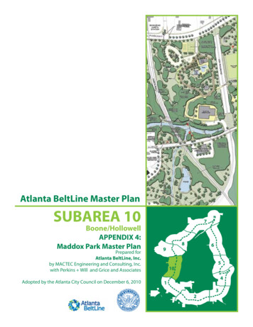
INTRODUCTIONMap 1. Maddox Park Master PlanOverviewThe master plan for Maddox Park is a guide andtool to be used to realize opportunities to improvethe park as an asset for the surrounding community,and the city as a whole. Future improvements andexpansions to greenspace and recreation facilitieswithin Maddox Park will serve as catalysts for newdevelopment and will also provide adjacentneighborhoods safer and more convenient access.As one of Atlanta’s historic public parks, MaddoxPark has served the community for over 80 years.While the park has seen many changes within andadjacent to its boundaries, the core area of thepark maintains its historic character and features.The elements of the master plan build on thehistoric character of the park and take advantageof its natural features, proximity to existing transitand access to the Atlanta BeltLine. The planincludes recommendations for preservation ofhistoric features, enhancement of existingamenities, construction of new features, andexpansion of the park from 52 acres to 84 acres.These improvements are designed to effectivelymeet the local need for greenspace and recreation.The Maddox Park Master Plan supports the community vision for park preservation, enhancement and expansion. This perspectiverendering illustrates the proposed park redevelopment concept at the east edge of Maddox Park.1ATLANTA BELTLINE MASTER PLAN December 6, 2010SUBAREA 10
PurposeThe Maddox Park Master Plan provides a detailedanalysis and vision for the future of Maddox Park.Developed through a public planning process,these recommendations for Maddox Park are aframework for park improvements. The masterplan provides a phased approach that, whenimplemented, achieves the vision for the future ofthe park that is shared by the community and theCity of Atlanta.Maddox Park AreaNMontgomery Ferry StopAnsley StopAmsterdam Ave. StopPiedmont Park StopGreeenwood Ave. StopPonce Park StopNorth Ave. Park StopElizabeth Ave. StopIrwin Ave. StopDecatur Street StopCabbagetown StopInman Park StopReynoldstown StopMemorial Drive StopGlenwood Ave. StopOrmewood Park StopConfederate Ave. StopBoulevard/Grant Park StopCherokee StopHill Street StopCarver StopPryor Road StopUniversity Ave. StopMetropolitan Parkway StopAdair Park StopMurphy Triangle StopLawton Street StopWest End/RDA StationWestview StationAshview Heights StopMozley Park StopWashington Park StopSimpson Road StopHollowell Parkway StopHowell Station StopMarie a Boulevard StopBlandtown StopHowell Mill StopNorthside Drive StopCollier Road StopPeachtree StopLindbergh StopArmour StopImportant information in this master plan isorganized by the following sections:Map 2. Subarea 10 Overview MapWHITAKER STPAINES AVLINDSAY STJAMES P BRAWLEY DR NWOLIVER STNEWPORT STPAINES AVLAWSHE STLAWSHE STY AVFERRNSEEPrepared By:withPerkins Will andGrice and AssociatesWEST END AVCUNNINGHAM STHAZEL STMILDRED STLEACH STRAYMOND ST NWRAYMOND ST SWRAYMOND ST SWMILTON STGRWESTVIEWNORCROSS STLUCILE AVPARK ST20HOWCULBERSON STOAK STDRSCALE IN FEETELL PLOAK STLEE STWest End ParkOAK STJAMES P BRAWLEY DR SWELIJAH STHILLTOP CRTALIAFERRO STPASCHAL BLMILTON STOZONE STBONAIR STOGDEN STLEGACY DRLEE STBALDWABBOTT STPEEPLES STLAWTON STJOSEPH E. LOWERY BLVDS PLNES JOABBOTT STIN PLAGNEHOLDERNESS STENGLISH AVTRAMMELL STNORFOLK STOLLIE STBOOKER ST NWPEEPLES STPARSONS PLLAWTON STROSSER STDARGAN PLDARGAN PLDARGAN PLHOPKINS ST SWWHITEHOUSE DRMORRIS BROWN DRFOUFENWOOD ST1ST STNAPOLEON DRWEST FAIR STNAPOLEON STATWOOD STHarris ChilesLUCILE AVWEST END PLMUSE STDean Rusk ParkGREENWICH STEGGLESTON STSELLS AVESELLS AVSTLANGHORN STBALDWIN STFAIR STJOYCE STNDSouth Gordon TriangleDRGREENWICH STHolderness /Lucie ParkNEWCASTLE STRD STRD STDRNTAINSWSTAFFOK DRANBUROCKRBMARTCHICAMAUGA PLCONNENOTA PLWESTSOUTHINMAN STMATHEWSON PLALTOONA PLLAUREL AVWELLINGTON STHOLDERNESS STLATHAM STAshleyTriangleParkOMMWILLARD AVWest EndMA Jones Elementary SchoolHAEAST ONTARIO AVSELLS AVGREENWICH STASHBY GRV03006001,200DUNN STONTARIO AVRPPARSONS STAtlanta University CenterSWWEST ONTARIO AVOFRefuge Church ofLord Jesus ChristApostolic FaithPARSONS STCAMILLA STY STNRBMITCHELL STDRUMMOND STPALMETTO AVHEWASHBY PLBECKWITH STFAIR STWESTVIEWGreen LeafCircleI-20Booker T. WashingtonHigh SchoolRN STMCALLISTER STStaffordStreet ParkFAIR STEnota PlacePlaylotWestviewSTOKES AVOntario ParkWest Hunter BranchAtlanta-Fulton Public LibraryJust UsFountainDrive #2CARTER STHARWELL STWELLBOSELLS AVSTAshbyMARTA StationPLAY LNMagnolia ParkMARTIN LUTHER KING JR. DR.HUNTER PLStaffordCircle ParkAshview HeightsWESTVIEW DR20SELLS AVJASPERSt. Paul'sChurchCharles L.Harper MemorialParkTemple ofIsrael ChurchHARWELL STPilgrim TravelersBaptist ChurchCALHOUN TEWESTVIEW DRSOUTH GORDON STDRCHAPPELL RDWESTVIEW PLPLMATHEWSONWESTVIEW PLMIMS STBRANTLEY PLELIXIR AVCHICAMAUGA AV SWWELLINGTON STTEEMERALD AVCERRO STCHICAMAUGA AV NWGARDENIA DRLAUREL AVNDOUGLAS STMOZLEY PLRACINE STOKipp-WayAcademyEUHRLEE STDSTGIDEONS DRMozley ParkDESOTO STWEBSTER STRTHURGOODARCHER STSHARON STRT DRSCHOOL PLSHARON STBOOKER WASHINGTON DRRDSTANHOPE CRWashington ParkOLEANDER STTHURMOND ST NWTHURMOND STMICHIGAN AVBERNARD STROC KMAFEDERAL DRGOAVWashingtonParkGARDENIA STMOZLEY PLIEERBRONX STPL NWCRAIG PLADELE AVARMRNKingdom Hall ofJehovahs WitnessesEASON STSHARON STS TEJ.F.KennedyParkPOND STCHESTNUT STTUAKRIDGE STCRMozleyParkIGHTBeltLine TADORR STAshbyCircle PlaylotWESTMOOR DRLENA STCRAIGHEADIACRBeltLineNEASON STAKRIDGE STARCSTAFFODRBURBANK DR NWCHSCOTT STURCHAPPELL RDINGTONCRROCK STOLLIE CREDWARDS STCHHOLLY RDSHSubarea 10English AveJOSEPH BOONE BLVDASHBYTESCIPLE TEWAANDREWS STMCCLURE AVEASON STEmmanuelChurch of GodASHBYOYSMAAHunter HillsRTAZOR STPLALTROY STFLOWERS PLCHILDS DRWESTSIDE DRRD NWWEST LAKE DRHAWKINS STLAVENDER DRVICTOCentenary UnitedMethodist ChurchAlonzo F. HerndonElementary SchoolMCALLISTERMOBILE STPIKE AVStudy AreaLegendEnglishAvePROCTOR STWYEZRSPRING LNERCOLLIER STWILLIS STLINDSAY PLBOLEY AVHOPKINS ST SWLANIER STNECHROME DRBOONE/HOLLOWELLDIVISION STARJOSEPH BOONE BLVDANDREWS STBeltLine Subarea 10:NEAL STTATE STNORRIS PLLindsey Street Baptist ChurchJETT STCONWAY PL NWSIMPSON RDCLIFFORD ALYLUDEN WYZENITH DRRDWEST AVTEMPLE STHOLLY STPELLCHAPAW DRKENNESCARLISLE STFOX STPELHAM STNORTH AVMaddox ParkLeathers CircleFOX STGRIFFIN STSIMMONS STETHERIDGE STMaddox ParkNORTH AVEARVILLA ST NWBellwood ChurchPELHAM STPOLAND STSIMMONS STPIERCE AVBLYSS AVGRIFFIN STLINDSAY STADDIE STHORNADY STRICE STGLASS STHALL STWHEELER STGrace Temple ChurchCAIRO STPLELBRIDGE DRGrove ParkHASTYTHOMS DRBEDFORD STDONALD L. HOLLOWELL PKWYFINLEY AVWOGARY AVJEFFERSON STHOR TENSMORAN STBankheadMARTA StationGeorgia Oliver Methodist ChurchNEKOMA STThis park master plan is part of the Subarea 10master planning process. It was developed duringthe community planning process for Subarea 10and supports the community’s vision for the area.LAW STODLANDPLElinorPlace ParkJEFFERSON STBankheadAtlanta BeltLine Planning ContextThe Maddox Park Master Plan is part of the largerAtlanta BeltLine project, a visionary transformationof the 22 mile loop of historic rail corridors aroundAtlanta. New parks along the Atlanta BeltLine willbe surrounded by places to live, shop and work, allconnected by transit, trails and transformed streets.N STLOVELESS AVAVWYSOSTIFF STFFERLOVELESS AVFRANCISFLORENCE PLImplementation – Presents the phasingoptions and planning-level cost estimates forpark improvements.JEGrove ParkPAINES AVJEFFERSON STMatilda Place ParkINOREL The Maddox Park Master Plan builds on the vision of the 2006Atlanta BeltLine Redevelopment Plan and other adoptedplans.WOODLAWN AVMaster Plan – Presents the vision and detailedplan for Maddox Park.REDEVELOPMENT PLAN NOVEMBER 200 5V IS I O N F O R THE BELTLIN EPL /FRANCIS PLConcept Development – Reviews alternativeconcepts developed during the planningprocess.36ELMWOOD RD Figure 6.1 Overall Framework Plan.PLInventory and Analysis – Documents thepark’s history, previous planning efforts,existing conditions, and opportunities for parkimprovements.FLORENCE E PLIntroduction – Summarizes the Master Planprocess and community engagement.HORTENSE Maddox Park is within Subarea 10 (Red outlines Subarea 10,with TAD parcels in tan).2SUBAREA 10APPENDIX 4: MADDOX PARK MASTER PLAN
Community EngagementThe Maddox Park Master Plan was the focus ofseveral meetings during the Subarea 10 planningprocess. One meeting in particular, held on April26, 2010, was devoted exclusively to Maddox Parkand the evaluation of alternative concepts.The community-identified issues and opportunities(stated below), the analysis of existing conditions,and review of previous planning efforts were usedto establish the vision for Maddox Park. This list isin no particular order and presents issues andopportunities identified during the planningprocess that specifically apply to Maddox Park.The master plan was developed as part of the Subarea 10planning process. Family friendly parks and up-grades areneeded. Trails that link to a larger system would be agreat community benefit. Maddox Park is not family friendly after work(i.e. after 5:00 p.m.). The City’s greenhouse at Maddox Park couldbe used for neighborhood beautification, localfood production, etc. Community programs for children are needed. Preserving and restoring historic structures andcultural sites is important to retain communityidentity and character. Maddox Park should connect with other parks. Educational programming with Proctor Creek isimportant. Better uses and activities are needed forMaddox Park. Phasing of park improvement projects isimportant to ensure park success. The natural topography and tree canopy needto be preserved and respected.Existing “tailgating”maintained. Truck traffic in Maddox Park is an issue.New paths or roads are needed between thepark and adjacent neighborhoods. Passive park uses and an arboretum arepotential elements of park expansion west ofthe MARTA line. Lighting improvements are needed for safetyand security. Maddox Park is within easy walking distancefrom MARTA station, one of the few Atlantaparks that is truly accessible directly fromexisting rail transit. Improving visibility into the park is importantfor safety.Public meeting participants discuss issues, opportunities andideas about Maddox Park and the surrounding area.activityshouldbe3ATLANTA BELTLINE MASTER PLAN December 6, 2010SUBAREA 10
INVENTORY ANDANALYSISThe purpose of the inventory and analysis is toprovide a detailed and comprehensive assessmentof existing conditions, opportunities and constraintsin the Maddox Park area. Available data, site visitsand review of previous planning efforts providedthe information for this analysis. Findings aboutthe park’s current condition and context supportthe resulting master plan.Park History and ContextMaddox Park is one of Atlanta’s oldest and mosthistoric parks. The area around Maddox Parkinitially developed as a first generation suburb ofAtlanta during the late 1800s and early 1900s.During this time period, the City of Atlanta createda municipal landfill on the property that is todayMaddox Park.As the area grew in prominence through the 1920s,several significant developments occurred in thearea including the creation of Maddox Park andWashington Park as well as the construction ofBooker T. Washington High School. Maddox Park’sconversion from landfill to park began in the late1920s and was completed in 1931. This initial parkdevelopment included the pool house, swimmingpond (later removed and replaced with a pool) andpavilion that remain today. The original boundariesof Maddox Park extended south to Boone Boulevardand incorporated the property that HerndonElementary School currently occupies.Over the years, the area around Maddox Park hasgrown and changed. From the 1930s through the1960s, a collection of middle class neighborhoodsgrew to surround the park. These neighborhoodsinclude Grove Park, Bankhead and English Avenue.From the 1960s through the 1980s, the area begana decline, losing roughly half of its populationduring this time period. Today, the area continuesto struggle to regain its prominence.The park and the area around it have also beeninfluenced by rail and industrial activity. TwoThis map from 1928 shows Maddox Park extending fromHollowell Parkway to Boone Boulevard (Simpson St.).prominent rail lines ran through the area: theAtlanta, Birmingham and Coastline Railroad andthe Louisville and Nashville Railroad. Portions ofboth rail lines remain today where the AtlantaBeltLine and the active CSX rail line pass throughthe park.The industrial properties that are south and east ofMaddox Park are relics of the area’s access to railservice. Those that remain today include bothactive and abandoned industrial businesses, aswell as city Public Works and WatershedManagement facilities. Several of these properties,including city-owned properties, have beenidentified as potential brownfield sites.Previous Planning EffortsThough there have not been any recent parkspecific planning efforts related to Maddox Park,there have been several community and city-wideplanning efforts that have identified Maddox Parkas an important park along the Atlanta BeltLineand in west Atlanta. The following is a is a summaryof these planning efforts.4SUBAREA 10APPENDIX 4: MADDOX PARK MASTER PLAN
Atlanta BeltLine Redevelopment PlanAdopted by the city in 2006, the Atlanta BeltLineRedevelopment Plan established study boundaries,presented the information required to create theAtlanta BeltLine TAD, and established the overallvision and framework for the Atlanta BeltLine. Aspart of the vision, new development will establishan interconnected network of parks, greenspace,trails and transit. Specifically related to MaddoxPark, the plan vision recommends the following: Expand Maddox Park to the west and south toincorporate portions of Proctor Creek. Improve the street network to provide betterneighborhood access to the park. Connect area parks using Atlanta BeltLinetransit and trails.The 2006 Atlanta BeltLine Redevelopment Plan envisions parkexpansion, an improved street network, trails and expandedtransit service for Maddox Park.The BeltLine Emerald Necklace: Atlanta’s NewPublic RealmDeveloped in 2004 by the Trust for Public Land, thestudy identified thirteen “jewels”(parks) that candefine the Atlanta BeltLine’s park network. MaddoxPark is identified as one of the thirteen “jewels” inthe report, and as one of the parks with potential toexpand. The other three similar parks are EnotaPark, Ardmore Park and Piedmont Park.In the report, several steps are outlined to improveand expand the park.The analysis andrecommendations include the following: Create better access and visibility – The parkis currently difficult to access from adjacentneighborhoods. Also, visibility of the parkfrom streets and adjacent development is lowbecause of the area’s topography. The reportrecommends extension of North Avenue acrossthe Atlanta BeltLine and connecting the AtlantaBeltLine trail to the park. Maddox Park as catalyst for new development - The report notes that successful expansion and improvement of the park willaccelerate redevelopment in the area. Newdevelopment adjacent to the Atlanta BeltLineand the park will increase activity and visibilityin the park. Relocate city facilities – The report identifiesthe need to relocate the Public Works operationsMaddox Park is one of thirteen “jewels” (parks) identifiedto enhance the Atlanta BeltLine and the City’s greenspacenetwork as part of the 2004 Trust for Public Land study.to another area of the city. The industrial natureof the facilities is not compatible with theresidential and recreational nature of the park. Expand the park – Expansion of the park westto Pierce Avenue and south to the Atlanta5ATLANTA BELTLINE MASTER PLAN December 6, 2010SUBAREA 10
Figure 9: West Subarea Greenspace System Concept34BeltLine and CSX rail line is recommended. Thisexpansion will allow new recreational activitiesto be located in the park. Improve maintenance – The reportalso identified the need to improve parkmaintenance. Several areas of the park needrestoration and general maintenance. Thereport notes that Maddox cannot be a greatpark unless proper management is part of theimprovement strategy.PKWYD.L. HOLLOWELL PHarwellHeights Park§ 20Wilson MillParkCompleted in 2009, Project Greenspace is Atlanta’smost recent greenspace master plan. The planestablishes a framework to improve, grow andmanage the city’s system of parks, natural areas,civic spaces, greenways and trails.The greenspace concept for the city includes anetwork of greenways and trails connecting parks(existing and proposed) and natural areas. Specificto the Maddox Park, the concept includes thefollowing. Creation of the Proctor Creek Greenway thatbegins at Maddox Park and extends north tothe Chattahoochee River. Connect near-by parks and neighborhoods toMaddox Park with multi-use trails. Expansion of Maddox Park to the west andsouth.Project Greenspace also includes a NeedsAssessment and Survey of the current system’sinventory, condition and future needs. Based onthe survey, the five highest priorities for citizens ofAtlanta are:Walking and biking trailsMozley ParkWestviewCemeteryComparison to Piedmont Park – The reportnotes that Maddox Park has many of the featuresof Piedmont Park, but it does not afford thesame level of activity, access or management.To take advantage of the natural areas, existingrecreational facilities and opportunities forexpansion, the park will need to be properlyfunded and managed.Project Greenspace 285285CAMPBELLTONMaddox ParkAdamsPark§ RDTERMS § Exis ng GreenspaceGreenspace Focus AreasExis ng and Poten al Connec onsProposed GreenwayExis ng GreenspaceCoreThe ProjectGreenspaceUrbanvisionfor MaddoxPark includesPriority Mul -use TrailsUndeveloped Land (Poten alLower Density AreaOther Mul -use Trails (Exis ng and Planned)Greenspace)The BeltLineexpandingthe park andlinking it tootherparks andBike Lanes/Arterial StreetsOther Arterial Streets (not classified as Bike Langreenspace withtrails,transitandgreenways.Electric U lity Corridors Data Source: City of Atlanta00.512MilesData current as of 2008 Nature centers/trails Small neighborhood parks (2-10 acres) Large community parks Indoor fitness and exercise facilitiesThe Needs Assessment also created level of servicestandards for park facilities in Atlanta. The standardsare based on the current level of service in the city,comparisons to standards in other major US citiesand projected need for facilities based onpopulation projects for the city to 2030. Based onthe recommended standards for Atlanta, the needfor park facilities is greatest for the following: Walking/biking trails Rentable picnic pavilions Outdoor pools Spray pads League play: Informal open practice fields Playgrounds Outdoor basketball courts Off-leash dog parks.Bankhead MARTA Station Transit Area LCI Study6SUBAREA 10APPENDIX 4: MADDOX PARK MASTER PLAN
Completed in 2006, this Livable Centers Initiative(LCI) study and focuses on the area around theBankhead MARTA station. The vision for the areaincludes transit-oriented mixed use developmentnear the MARTA station and along HollowellParkway.Specific to Maddox Park, itsrecommendations include: Develop a Maddox Park Master Plan to guideexpansion of the park and park improvements. Remove city Public Works facilities fromMaddox Park. Relocate all non-park buildings and facilitiesfrom Maddox Park. 3:5expansion of Maddox Park and higher intensity developmentDevelop a Proctor Creek Greenway –Sectionusing3: eltLine.the floodplain and stream buffer – to connectMaddox Park to areas along Proctor Creek northand west of the park. Increase activity at the edges of MaddoxPark with new, higher density mixed use andresidential development. Improve access to Maddox Park with newstreets, pedestrian connections, trails andtransit service.The Bankhead MARTA Station LCI Study concept includesPark UseCurrent activity in the park is a mix of socialgathering and limited recreational activity. Thecurrent facilities, and their condition, limit thequality of recreational activity and also impact thelevel of safety (and perceived level of safety) in thepark. Recreation Activity – The park facilities, in theircurrent condition, support minimal recreationactivity. Based on observation, the multi-usefield is infrequently used for pick-up ball gamesas well as a golf practice. The basketball courtsare used for informal pick-up games, mostoften during the large community gatherings.There are no organized sports that take place inthe park. The pool is closed indefinitely due tolack of reconstruction funding.Park Rhythm - Based on observation, the parkexperiences the greatest level of activity after5pm on weekdays and on the weekends. During these time periods, large gatherings typical-The basketball and tennis courts are located in the historiccore of the park.ly occur in the parking areas of the historic core.During weekday mornings and afternoons, parkmaintenance crews and unemployed or homeless men appear to be the primary park users. Social Gathering – Maddox Park is a popularafter-work and weekend destination forcommunity gathering. Rather than takingadvantage of the picnic areas, however, the largegatherings are focused within and adjacent tothe parking areas in the park. Based on parkvisits during these gatherings, attendees arepredominately male and between the agesof 18 and 64. Families and children were notobserved to be a part of these gatherings.7ATLANTA BELTLINE MASTER PLAN December 6, 2010SUBAREA 10
Map 3. Existing ConditionsHollowell Parkway Construction Zone (Active)To Future Westside Park/Potential Extension ofProctor Creek GreenwayHistoric ParkGateway/EntrancePlanned BeltLine TransitStation LocationCSX RailBrdigeBankheadMARTA StationParkEntranceHollowell ParkwayPlayground/Picnic AreaHistoric Pooland Pool HouseMulti-UseFieldProctor Creek Floodplain/Potential Park Expansion AreaRolling TopographyRRTAMAPierce AvenueEroded StreambanksSteep Slopeof Flo wDirneectionTennis andBasketball CourtsiBeltLMARTABridgePrivate Property/Industrial UseHistoric PavilionCity GreenhouseailLineProctorCreekSteConcrete Pipe/Check DamConcreteCulvertNorth AvenueMARTABridgeep SlopeCSX RailBridgeNorth AvenueConcreteCulvertCity ParkMaintenance BuildingDirectionofFlowDirection of FlowProctor CreekChannelizedStream CorridorCity Public Works,Watershed ManagementComplexPrivate Property/Industrial Use/Potential Park Expantion AreaConcreteCulverteil LinX RaSCSteep SlopesPotential FutureGreeenwayBeltLine Subarea 10To Boone BoulevardLEGENDMaddox Park BoundaryBeltLineCSX Rail LineMARTA Rail LineBOONE/HOLLOWELLoExisting ConditionsStream/CreekPrepared By:withPerkins Will andGrice and Associates0100200400SCALE IN FEET8SUBAREA 10APPENDIX 4: MADDOX PARK MASTER PLAN
City Greenhouse – The city Parks Departmentuses the greenhouse in Maddox Park to growplants for city parks and municipal buildings. Itis currently fenced off and only used by ParksDepartment employees.In addition to typical park uses in Maddox Park, thecity uses the southeast portion of the park to houseseveral city maintenance operations. The facilitiesinclude fleet vehicle services, water managementoperations, forestry and waste trucks. The heavyvehicles that travel to and from the facilities impactthe adjacent neighborhoods and park.Illegal activity in the park is also a concern, accordingto park users and the Atlanta Police Department.Selling drugs and other illegal activity is an issueduring day and evening hours. The limited visibilityand activity in the park contributes to this issue.Large gatherings congregate in, and adjacent to, the parkingareas, rather than the green areas of the park.Issues Active rail lines pass through the park, makingcertain areas of the park difficult or unsafe toaccess. Families with children infrequently use MaddoxPark. The park is rarely used during the daytime onweekdays. The parking habits of park visitors during largesocial gatherings is a safety concern whereparked cars limit fire and emergency vehicleaccess. Daytime use of the park is low.Illegal activity (real and perceived) negativelyimpacts safety and park use.Opportunities Increasing development around the park canincrease activity in the park during weekdaysand daytime hours. Improvements to make the park to be morevisible and accessible will increase activity inthe park and the perceived level of safety. New recreation amenities can serve a widerdemographic, especially children and families. Relocation of the Public Works operations willallow for park expansion and remove the noiseand heavy vehicle impact on the adjacentneighborhoods.Heavy vehicles associated with the Public Works operationstravel through adjacent neighborhoods.9ATLANTA BELTLINE MASTER PLAN December 6, 2010SUBAREA 10
InfrastructureOne street and one driveway enter the park,providing vehicular access. North Avenue formsthe edge of the park’s southern boundary beforeturning north and connecting to Hollowell Parkway.Access to the multi-purpose field and Public Worksis from North Avenue, as is a small amount ofinformal parking.Nearer to the Bankhead MARTA station, a drivewayprovides vehicular access to the historic core fromHollowell Parkway. This driveway loops around thepool house and also has a spur that providesvehicular access to the greenhouse. Currently,cement bollards block vehicles from traveling thecomplete loop – effectively creating a dead-enddriveway. Parking is adjacent to the pool house,and during large social gatherings, vehicles parallelpark along the driveway loop. This is a safety hazardas it hinders fire and emergency vehicle access.Pedestrian facilities near and within the park areminimal and in poor condition. Along NorthAvenue, from Chappell Road to Hollowell Parkway,there are no sidewalks. Along Hollowell Parkway,sidewalks either do not exist or are in very poorcondition, th
we stvie dr m a y s o n r t u r n e r r d north ave donald l. hollowell pkwy 20 20 martin luther king jr. dr. b ankhe d marta sta tion l a w t o n s t j o s e p h e. l o w e r y b l v d ashby marta station l e s t sim p o rd g r i f f i n s t c h a p e l l n r d l a w t o n s t oak st o l i v e s t neal st lena st j a m e s p b r a w l e y d r .