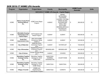
Transcription
Continuous Monitoring in MWRA’sEffluent Discharge Ambient Monitoring ProgramCooperative Project with NOAA National Data Buoy Center 2009-2012BACKGROUNDAs part of its Effluent Outfall Ambient Monitoring Plan, MWRA has used continuous measurementsfrom moorings in Massachusetts Bay. The primary source of continuous data since 2005 has been theNERACOOS Buoy A off Cape Ann. Because there was interest in gathering continuous data closer to itsoutfall, MWRA worked with NDBC to add oceanographic measurements to its weather buoy 44013 justsoutheast of the outfall http://www.ndbc.noaa.gov/station page.php?station 44013.MWRA and NDBC entered into a cost-sharing cooperative research agreement in April 2007. At thattime, NDBC was exploring whether to become fully involved in ocean monitoring. Since then, federalfunding limitations and catastrophic events such as hurricanes and the gulf oil spill forced NDBC toprioritize its interests—and ocean monitoring is now a lesser priority. The MWRA-NDBC collaborationended December 2012, and NDBC has made it clear that any potential follow-on contract will not includea cost-share on its part. For reasons detailed below, MWRA believes its future investment in continuousmonitoring is best used to help support monitoring on NERACOOS’ Buoy A off Cape Ann.Ambient Monitoring Plan requirementMWRA’s Ambient Monitoring Plan 1 includes the following description of continuous measurements:“Continuous measurement of biological parameters. MWRA tracks data from the Gulf of MaineOcean Observing System (GoMOOS 2008) 2 monitoring buoy off Cape Ann, and has addedchlorophyll measurements to that buoy. In addition, a suite of water quality instrumentation hasbeen placed on the NOAA weather buoy 44013 just south of the outfall site. Data from bothbuoys are available in real time.”The goal of the continuous monitoring, along with the use of satellite data, was to complement the nineyearly shipboard surveys by providing data in between surveys and capture short-term events. Unlike theearlier collaboration (1989-2006) with USGS, which had measured currents, near-bottom dissolvedoxygen, and sediment movement from a tripod that sat on the sea floor near the outfall, the emphasis wasto be on real-time reporting of the oceanographic measurements, and it would include near-surface andsubsurface water quality monitoring.Background on this part of the monitoring plan is found in the earlier version of the Ambient MonitoringPlan: 3“Continuous measurement of biological parameters. As recommended by OMSAP (October 21,2003), MWRA plans to hold a workshop on May 19, 2004 to discuss the goals, issues,1MWRA. 2010. Massachusetts Water Resources Authority effluent outfall ambient monitoring plan Revision 2.July 2010. Boston: Massachusetts Water Resources Authority. Report 2010-04. 107 p.2GoMOOS. 2008. Gulf of Maine Ocean Observing System. Retrieved from http://www.gomoos.org/3MWRA. 2004. Massachusetts Water Resources Authority effluent outfall ambient monitoring plan Revision 1,March 2004. Boston: Massachusetts Water Resources Authority. Report 2004-ms-92. 65 p.1
technologies, and costs of augmenting its ambient monitoring with continuous water qualitymonitoring and additional use of satellite data. Some suggested goals include detecting eventsthat should be sampled, and providing coverage between scheduled surveys to compensate forfewer scheduled surveys. Following the workshop, OMSAP may recommend further evaluation,or may recommend implementation of specific technology (for example adding chlorophyllsensors to the existing GoMOOS mooring off Cape Ann, or providing USGS mooring data inreal-time). Some recommendations could be implemented later in 2004.”Further details on the rationale can be found in the minutes4 to the June 18 &19 2003 OMSAP meeting:“OMSAP also recommends that these changes be approved on the condition that MWRAaugment the instrumentation on the USGS and NOAA moorings near the outfall that collectcontinuous water quality data. Continuous dissolved oxygen data, for example, would helpdetermine when phytoplankton blooms begin, end, and decompose. OMSAP members suggestedthat the moorings have about five sensors (2-3 in the surface mixed layer, 1 mid-depth, and onebottom) that measure dissolved oxygen, salinity, temperature, fluorescence, and possibly otherparameters such as longwave and shortwave radiation. MWRA agreed to report back to OMSAPin the near future on their plans for adding instrumentation to the moorings. MWRA should take advantage of innovations in water quality monitoring such as satelliteinformation and continued improvements in the technology and reliability of instruments that areattached to moorings and collect continuous water quality data. Though the recommendedrevisions will still provide enough information about the nearfield, these technological advancescan supplement the monitoring results at a lower cost than mobilizing a field survey. The use ofcontinuous data would also facilitate a potential transition from fixed/scheduled sampling toresponsive sampling (e.g. mobilizing a survey when sensors in Mass Bay indicate high surfacedissolved oxygen during a phytoplankton bloom).”Challenges to continuous monitoring of near-surface water quality in Massachusetts BayAfter the end of the USGS mooring project in early 2006, MWRA investigated several possibilities forongoing continuous measurements near its outfall. The Outfall Monitoring Science Advisory Panel(OMSAP) recommended that any continuous measurements be telemetered so they could be available inreal-time. One recommended measurement was near-surface oxygen saturation, which could serve as anindicator of the high productivity rate associated with a spring bloom. These requirements meant that themooring would need to have a surface expression.Unfortunately, the outfall is located in a heavily-traveled shipping lane and there is considerablecommercial groundfishing activity in the area, making ship strikes and interference with fishing serioushazards associated with a surface buoy. Any mooring in the area must be robust enough to withstand thenets of draggers, and visible enough to avoid being a navigation hazard, without causing confusion withexisting aids to navigation. Rapid biofouling of near-surface submerged instrumentation requiresfrequent maintenance of the instruments (such as is done in Narragansett Bay). In addition, the cost ofinstalling and maintaining a moored instrumented buoy similar to Buoy A would be high. Even ifMWRA can benefit from existing buoys and instrumentation from the NERACOOS program, annualdeployment and maintenance costs of such a new buoy are likely to exceed 120,000.In an attempt to solve the siting, fouling, cost, and real-time communication challenges, MWRApartnered with NDBC to add oceanographic instrumentation to its weather buoy near MWRA’s outfall.The existing, well-known Buoy 44013 platform presumably would be less prone to ship strikes; NDBCwas having success using instrumentation installed in a box above the water which would minimize4OMSAP, 2003. Minutes of the June 2003 OMSAP AP0603.pdf, retrieved November 28, 2012.2
fouling; MWRA would share the buoy’s existing real-time data communication technology; and NDBCwould contribute a cost-share, making the arrangement financially feasible.Figure 1 shows the location of the NERACOOS Buoy A and the NDBC Buoy 44013. Buoy A is 21 kmfrom Buoy 44013. Buoy 44013 is 11.6 km southeast of the offshore end of the MWRA outfall, whileBuoy A is 25 km northeast of it. MWRA’s water quality monitoring locations are also shown.Figure 1 NDBC and NERACOOS buoys in Massachusetts Bay, MWRA outfall, and water column monitoringstations.3
Related programsThere are several moorings in the Gulf of Maine that are part of the Northeast Regional Association ofCoastal Ocean Observing Systems (NERACOOS, www.neracoos.org). These are maintained by theUniversity of Maine (UMaine) and have a variety of weather, oceanographic, and water qualitymeasurements that are available in real-time. MWRA funds a portion of the cost of the buoy nearest to theoutfall, Buoy A off Cape Ann, at a cost of 80,000/year—the funding includes monitoring near-surfacechlorophyll fluorescence. Buoy A transmits real-time data on currents, water temperature, salinity, anddissolved oxygen at multiple depths. All the data from the UMaine buoys are available in real time fromthe UMaine and NERACOOS web sites.Other nearby buoys include thirteen right whale listening buoys deployed by the Cornell Lab ofOrnithology http://www.listenforwhales.org/page.aspx?pid 467 (Figure 2) to detect right whales inMassachusetts Bay and report their presence in real-time.Figure 2 Right whale listening buoys in Massachusetts Bay.4
The Stellwagen Bank National Marine Sanctuary has a pilot project to study ocean acidification thatincludes continuous measurements from a buoy within the sanctuary, from December 2011-June 2012,with plans for a possible longer deployment in the near future (Ben Cowie-Haskell, NOAA, personalcommunication 2012). Oceanographic data from this pilot study were not telemetered in real time.NDBC MOORING PROJECT DESCRIPTIONAgreement between NDBC and MWRAMWRA partnered with NDBC in an attempt to solve the problems of siting, fouling, and real-timetransmission of data that exist near the outfall. NDBC was interested at the time (2006-2007) inenhancing its extensive weather buoy network with oceanographic and biological measurements, and hadhad some success in the southeastern US with the “Ocean Sensor Module” (OSM). The existing NDBCmooring 44013 is relatively close to the outfall (11.6 km), well-lighted and sturdy, and NDBC alreadywas telemetering weather and sea-surface temperature data and reporting them in real-time on its website.The OSM was developed by the International Seakeepers Society as an instrumentation package thatcould be deployed on vessels of opportunity. It is an above-surface, flow-through system which pumpswater past the sensors and incorporates electrolytic chlorination to control fouling.MWRA and NDBC agreed that NDBC would continue its existing measurements and enhance them withtemperature, salinity, and ocean current sensors using NOAA funding, while MWRA would contributestart-up funding to purchase the OSM, water quality sensors, and upgraded current meters, and pay amodest annual maintenance fee after the first year of operation.The original plans with NDBC included changing the cabling of the buoy to allow inductively coupledsensors, to be provided by MWRA, to be deployed at depth. This would have permitted real-timereporting of data from sensors at depth.An agreement between MWRA and the NDBC was executed in April 2007, and the initial four-year termwas intended to run through December 2010. However, there were delays caused by technical difficultiesand internal NOAA funding problems. In addition, NOAA’s buoy program suffered the destruction ofother navigational buoys by hurricanes; NDBC used available buoys to replace the destroyed ones ratherthan using them for the MWRA project. As a result, the current meters were not deployed until January2009 and the water quality instruments not until June 2009. The end date of the agreement was delayed toDecember 2012.As a result of resource constraints and changed priorities in NDBC’s buoy program, by the time the newBuoy 44013 was deployed in 2009, plans for inductive cabling had to be abandoned. Therefore, thesystem as deployed could not support telemetry from subsurface sensors.MWRA contributions to NDBC monitoring collaborationMWRA has contributed significant resources, both financial and scientific staff time, in order to obtainreal-time surface water quality measurements at Buoy 44013.FinancialMWRA’s share of the joint funding agreement with the NDBC has been approximately 40,000 per year.In addition to those costs, MWRA has funded logistical support for buoy servicing and maintenanceunder its other ambient monitoring contracts, at a cost of approximately 20,000 per year. (This cost ofcontinuous monitoring is in addition to the 80,000 per year that MWRA currently contributes toNERACOOS for operation and interpretation of data from Buoy A.)5
Staff time contributionSince the water quality sensors on Buoy 44013 were first deployed in June 2009, MWRA has devotedapproximately 300 hours of senior staff time to assisting with the physical installation of the OSM,processing the data from the buoy, carrying out QA, and calibrating the data to field measurements fromits ambient monitoring program. Additionally, MWRA initiated a project to “winterize” the system,modifying the pumps, manifolds, internal plumbing and control software to provide the capability foryear-round telemetry. That effort, coupled with program management and administration have requiredroughly an additional 2,000 hours of staff time on the part of senior MWRA scientists and engineers.AdvocacyWhen the mooring was lost shortly after the December 2011 deployment, mariners and coastal scienceadvocates including MWRA advocated for its rapid replacement. Without this pressure, it is likely thatNDBC would have chosen not to replace this buoy and the meteorological as well as oceanographicmeasurements at that location would have come to an end.RESULTS TO DATEOverall performanceDespite the best efforts of the NDBC and MWRA, as of December, 2012 technical and logisticalproblems have meant that surface chlorophyll fluorescence and dissolved oxygen measurements havebeen available in real time from Buoy 44013 for only about half the time since the sensors were deployedin June 2009. Non-telemetered winter fluorescence measurements were available an additional 22% of thetime.In contrast, surface fluorescence measurements have been made at the NERACOOS Buoy A sinceOctober 2005, and since June 2009 have been available 99.6% of the time. Surface oxygen measurementswere added to Buoy A in October 2011, and have been available 88% of the time since then.CurrentsSurface current data are available from Buoy 44013 for a short time in 2009 and intermittently throughmost of 2010. Subsurface data from the acoustic Doppler current profiler are available for a short time in2009 and then very briefly in the spring of 2010. The current meters failed due to biofouling and toproblems with power and data cables, and were not replaced. By then, Federal matching funds to supportthis part of the project were unavailable due to congressional budget cuts. Given the limited resources, theproject team focused on surface chlorophyll and dissolved oxygen rather than currents.Figures 3 and 4 show the current meter data (daily averages, selected depths) available between January2009 and June 2011, from Buoy 44013 (Figure 3) and NERACOOS Buoy A (Figure 4). The data areshown on the same scale and at similar depths for comparison. Except for the shallowest depth,measurements were made with an acoustic Doppler current profiler, which provides data for every 4 mdepth interval through the water column.Measured current speeds at the Cape Ann buoy are higher and more variable. This is consistent with theresults of the Massachusetts Bays Program study 5 of the physical oceanography of the bay conducted in5Geyer WR, Gardner GB, Brown WS, Irish J, Butman B, Loder T, Signell RP. 1992. Final Report to theMassachusetts Bays Program: Physical oceanographic investigation of Massachusetts and Cape Cod Bays.October 1992. Boston: Massachusetts Bays Program. Report MBP-92-03. 497 p.6
1989-1991. Figure 5, copied from that report, shows the low-frequency ellipses for moorings around thebays. As shown on Figure 5, Buoy U2 was close to the present location of Buoy A; Buoy BB was close tothe present location of Buoy 44013. (See also Figure 4.6 C1302 Section4.OceanSetting.pdf.)7
5030301.6m westward speed (cm/s)1.6 m eastward speed 29m westward speed 3053m westward speed -5029m eastward speed (cm/s)-3050-3053m eastward speed (cm/s)-10-50Apr-099m westward speed (cm/s)9m eastward speed pr-10Jul-10Oct-10Jan-11Apr-11Jul-11Jan-09Figure 3 Current meter measurements from NDBC Buoy 44013, January 2009-June 2011, selected depths. East component of velocity on left, north componenton right.8
5030302 m westward speed (cm/s)2 m eastward speed 0Jul-10Oct-10Jan-11Apr-11Jul-1110-10-30Jan-0930 m westward speed 3054 m westward speed Apr-095030 m eastward speed (cm/s)-3050-5054 m eastward speed (cm/s)-10-50Apr-0910 m westward speed (cm/s)10 m eastward speed pr-10Jul-10Oct-10Jan-11Apr-11Jul-11Jan-09Figure 4 Current meter measurements from NERACOOS Buoy A, January 2009-June 2011, selected depths. East component of velocity on left, northcomponent on right.9
Figure 5 Mean flow and low-frequency variability for near-surface current measurements December 1989September 1991 (Figure 2.2-17 from Geyer et al. 1992).Temperature and SalinityFigures 6 and 7 show the temperature and salinity data (daily average) from NDBC Buoy 44013 (orangelines) along with those from the nearby NERACOOS Buoy A (blue lines).Surface temperature and salinity were measured at Buoy 44013 except for the December 2011-June 2012period when the mooring was lost and had not been redeployed, shown as a horizontal orange arrow onthe figures.Because it turned out that the OSM could not be deployed during the winter months (see “Summary ofProblems Encountered with Buoy 44013,” below), telemetered data were not available for temperature,salinity, dissolved oxygen, chlorophyll, or turbidity during those winter deployments. During the wintersof 2009-2010 and 2010-2011, however, NDBC and MWRA put instruments to measure temperature,salinity, and chlorophyll fluorescence on the mooring bridle under the buoy, to obtain near-surfacemeasurements that were then available after the instruments were retrieved (not in real-time).NERACOOS Buoy A also has temperature and salinity measurements at 20 m and 50 m (not shown.)10
The surface temperature and salinity measurements at the two moorings are very closely correlated, andshow the seasonal variation. Since the NERACOOS Buoy A is closer to the Merrimack River discharge,which often enters Massachusetts Bay in the spring, it shows a greater effect of the spring freshet thandoes NDBC Buoy 44013.A pump failure at Buoy 44013 in fall 2011 rendered unusable data from several of the sensors on theOSM–this time period is shown with a brown arrow on the figures. Shortly thereafter the buoy was lostand not redeployed until late the following spring.Salinity data from Buoy 44013 after June 2012 are questionable, because the only salinity-conductivitytemperature sonde compatible with the OSM hardware and the NDBC software is obsolete and is nolonger supported by the manufacturer. It could therefore not be factory-calibrated prior to the June 2012redeployment.11
24NERACOOS Buoy A (1 m)NERACOOS Buoy A (2 m)NDBC Buoy 44013 (0.5 m)22NDBC Buoy 44013 (2.4 m, not real-time)201816Temperature (C)1412108pump failure6421244013 buoylost
Figure 6 Daily average near-surface temperature measurements from NERACOOS Buoy A and NDBC Buoy 44013, January 2009-December 2012.pump failure33Salinity (PSU)312927NERACOOS Buoy A (1 m)NDBC Buoy 44013 (0.5m)NDBC Buoy 44013 (2.4 m, not real-time)44013 buoylost25Figure 7 Daily average near-surface salinity measurements from NERACOOS Buoy A and NDBC Buoy 44013, January 2009-December 2012.13
ChlorophyllFigure 8 shows the chlorophyll fluorescence data (daily median) from the NDBC Buoy 44013 (orange lines)along with those from the nearby NERACOOS Buoy A (blue lines), along with shipboard measurements fromsurface samples collected near the two moorings (yellow circles and brown diamonds for 44013 and blue trianglesfor Buoy A.) Because of diel variation caused in part by non-photochemical quenching, Collin Roesler, theprincipal investigator for the Buoy A fluorescence measurements, recommends using the daily median values asthe most robust estimate of in situ chlorophyll. 6 Thus the daily median values are shown in Figure 8.As noted above, during the winters of 2009-2010 and 2010-2011, near-surface measurements of fluorescencewere available only after the instruments were retrieved.Surface chlorophyll data from the NERACOOS Buoy A off Cape Ann were in reasonable agreement with thesurvey data, both methods documenting the strong spring blooms in April 2009 and April 2010, lower chlorophylllevels through most of the summer, and increased chlorophyll during a fall bloom (Figure 8). The shipboard datado not capture the highest peak values of this variable data set.Chlorophyll data from NDBC Buoy 44013 near the outfall also documented the strong spring bloom in 2010,however Buoy 44013 summer and fall chlorophyll measurements were higher than were measured during the shipsurveys. The high chlorophyll measurements were probably due to a defective sensor; there was a steep drop inchlorophyll measurements when one sensor which stopped reporting data in late October 2010 was replaced inmid-November 2010. Data from Buoy 44013 in spring 2011 are similarly much higher than both the shipboardmeasurements and Buoy A data, and may indicate another sensor failure after about June 2011. The shipboardmeasurements indicate that surface chlorophyll at the two buoy locations should be more similar than themeasurements show.There were wintertime sonde fluorescence measurements made at Buoy 44013 (not real-time) during the wintersof 2009-2010 and 2010-2011 (dotted brown line on Figure 8); these generally show much lower values than eitherBuoy A or the shipboard measurements. The chlorophyll data are noisy and it is not entirely clear whether onlythe Buoy 44013 OSM chlorophyll sensor shows too-high values, or if sensors on both Buoy 44013 and Buoy Ahave this problem.The Buoy A data benefit from post-processing corrections by Dr. Collin Roesler of Bowdoin College, who hasbeen making moored fluorescence measurements in the Gulf of Maine since 2005. In general, the Buoy Ameasurements match shipboard measurements at nearby stations off Cape Ann, much better than Buoy 44013measurements match shipboard measurements taken in western Massachusetts Bay. In fact, based on theshipboard measurements, the two locations have very similar chlorophyll, more so than is apparent from acomparison of chlorophyll measurements at the two buoys. The timing of spring and fall blooms is apparent atBuoy A. At Buoy 44013 the data do not show a large spring bloom. 7 The Buoy 44013 chlorophyll variation inthe fall bloom period is sometimes obscured by apparent instrument drift, possibly due to fouling.6Roesler, CS. 2011. Calibration and Correction of the Chlorophyll Fluorometer on GoMOOS Buoy A01: Nov 2005 – Apr2011. Boston: Massachusetts Water Resources Authority. Report 2011‐15. 8 p.7The Buoy 44013 early spring data were not available in real-time and were only obtained after the sonde was recovered inlate spring.14
25NERACOOS Buoy A (3 m)NDBC Buoy 44013 (0.5 m)20NDBC Buoy 44013 (2.4 m, not real-time)44013 buoylostWC surveys surface fluorescence (stations AF8, AF9, F22 near Buoy A)Chlorophyll concentration (ug/l)calibration surface chlorophyll sample at NDBC buoy 44013pump failureWC surveys surface fluorescence (stations N07, AF5 near Buoy 44013)151050Figure 8 Daily median, near-surface chlorophyll fluorescence measurements from NERACOOS Buoy A and NDBC Buoy 44013, along withcorresponding shipboard measurements, January 2009-December 2012.15
OxygenFigures 9 and 10 show the oxygen concentration and percent saturation data (daily average) from Buoy44013 (orange line) and Buoy A (blue line), along with shipboard measurements from surface samplescollected near the two moorings (yellow circles and blue triangles, respectively).Measurements of near-surface oxygen at Buoy A began in October 2011 and continued through thewinter, providing the first continuous surface measurements of oxygen in MWRA’s outfall ambientmonitoring area over the period of the spring bloom. Late winter 2012-early spring 2012 measurements atBuoy A indicate that the shipboard surveys captured the peak of the spring bloom. Degradation of thesensor, presumably due to fouling, was observed at the end of the summertime deployment in SeptemberOctober 2012 and these data were not included on the plot.NERACOOS Buoy A also has oxygen measurements at 50 m (not shown).Summertime continuous Buoy 44013 measurements roughly follow the pattern of the shipboardmeasurements. Oxygen data from 44013 are currently under review, because their factory calibration isuncertain. Estimated results, which have an approximate calibration applied by MWRA, are shown onFigures 9 and 10. From comparison to shipboard measurements, the approximate calibration appears tounderestimate dissolved oxygen values during the first three summer deployments and overestimatedissolved oxygen during the final deployment16
13.5NERACOOS A (2 m)NDBC Buoy 44013 (0.5 m)WC surveys surface DO (stations F22, AF8, AF9 near NERACOOS Buoy A)WC surveys surface DO (stations N07 and AF5 near NDBC Buoy 44013)12.5calibration surface DO sample at NDBC buoy 44013calibration surface DO (YSI probe) at NDBC buoy 44013Oxygen concentration (mg/l)11.510.59.58.5pump failure6.544013 buoylostfouling of Buoy A DO sensor7.5Figure 9 Daily average near-surface oxygen concentration measurements from NERACOOS Buoy A and NDBC Buoy 44013, along with correspondingshipboard measurements, January 2009-December 2012.17
130Oxygen saturation (%)120110100NERACOOS Buoy A (2 m)pump failureNDBC Buoy 44013 (0.5 m)WC surveys surface DO (stations F22, AF8, AF9 near NERACOOS Buoy A)WC surveys surface DO (stations N07 and AF5 near NDBC Buoy 44013)calibration surface DO (YSI probe) at NDBC buoy 4401344013 buoylostfouling of Buoy A DO sensor9080Figure 10 Daily average near-surface oxygen saturation measurements from NERACOOS Buoy A and NDBC Buoy 44013, along with correspondingshipboard measurements, January 2009-December 2012.18
SUMMARY OF PROBLEMS ENCOUNTERED WITH BUOY 44013Orphaned pilot studyAt the time the project was developed, NDBC had a project to enhance its extensive weatherbuoy network with oceanographic and biological measurements. Therefore it made sense to“piggyback” on the existing mooring platform, as for a modest cost MWRA could obtain thedesired data and NDBC would extend its biological monitoring network to a new area. However,technical difficulties delayed the project start, and after 2007 the NDBC’s priorities had shiftedaway from continuous oceanographic and biological monitoring. Obtaining sufficient resourceswithin NDBC was a continual struggle for the project team. Furthermore, buoyrecovery/deployment cruises were often delayed because the large vessels required were neededto deal with emergencies such as Hurricane Ike or the Deepwater Horizon oil spill.Because of the pilot nature of the project, several hoped-for enhancements to the 44013 buoynever became reality. For example, subsurface measurements were not possible because theOcean Sensor Module data acquisition system could not be made to work with the acousticmodem. Also, the “Waverider” buoy used for NDBC Buoy 44013 needs a long length of slackchain, so deployment of instruments near the bottom is not possible with this buoy. Plans toredesign the mooring system to incorporate inductive cabling had to be abandoned due toresource constraints on the part of NDBC.Safety constraintsFor power, Buoy 44013 relies, like other NDBC weather buoys, on lead acid batteries within thebuoy’s steel hull. During long deployments in the marine environment, these batteries have thepotential to malfunction and generate explosive concentrations of hydrogen gas. NDBC standardoperating procedures require that no work can occur on the buoy unless an NDBC staff memberparticipates and certifies the absence of dangerous levels of hydrogen. Coordinating theschedules and travel of NDBC staff from their headquarters at the Stennis Space Center inMississippi complicates the logistics of maintenance surveys.Harsh boreal weatherPrevious NDBC biological monitoring efforts had been focused on waters off the southeasternUnited States. Prior to the January 2009 redeployment of Buoy 44013, which had been retrofittedto allow deployment of the OSM and the current meters, the project team realized that the OSMwas vulnerable to freezing, because seawater is pumped up to a box on the surface of the buoy,where temperatures can fall well below –2 oC. Therefore, the OSM box was not installed untilJune 2009 and was removed for the winter deployments (2009-2010 and 2010-2011). AlthoughNDBC was able to
Cooperative Project with NOAA National Data Buoy Center 2009-2012. BACKGROUND. As part of its Effluent Outfall Ambient Monitoring Plan, MWRA has used continuous measurements from moorings in Massachusetts Bay. The primary source of continuous data since 2005 has been the . Buoy A transmits real-time data on currents, water temperature .