Transcription
Chapter 4Basin MonitoringNile Basin Water Resources Atlas / 75
Key messagesThere are approximately 928 meteorological and 423 hydrometric stations in the NileBasin. Over 70 percent of the meteorologicalstations measure either just daily rainfall totals or rainfall and temperature. Most hydrometric stations measure river or lake waterlevels. Monitoring of water quality, sedimenttransport in rivers, and groundwater are attheir early stages in most countries. Datatransmission from the stations to centraldata repository in most countries is manual.76 / Nile Basin Water Resources AtlasThe current total number of national monitoring stations in the Nile Basin countries iswell below its historical maximum. Staff andfinancial resources to operate and maintainthe complete national network of stationsare limited in all countries. Automated datatransmission using modern technology isbeing newly introduced in many countries.In all countries the potential use of data forreal-time water resources management is notrealized because of a lack of telemetry anddata processing and management systems.There have been national as well as regionalinitiatives to improve river basin monitoringin the Nile Basin. The Nile Basin Initiative hasrecently completed the design of a Nile Basinregional Hydromet system. This system willcomprise a set of 323 meteorological and 79hydrometric stations, groundwater and waterquality laboratory strengthening and monitoring use of remote sensing for monitoringriver basin processes. The system relies onexisting monitoring stations to be upgradedto meet the requirements as a regional monitoring network with few new stations addedwhere no current monitoring stations exist.The IGAD-HYCOS is another regional initiative that has supported member countries ofthe IGAD to upgrade their hydrological monitoring network; some of these stations are inthe Nile Basin.
introductionOverviewmeteorological parameters. In additionThis chapter presents the current stateto the stations that are established andof water resources monitoring in themaintained by National MeteorologicalNile Basin. The focus of the chapterServices agencies, there are other net-is primarily on hydro-meteorologicalworks that have been put in place for spe-monitoring with additional informationcific purposes. An example of such specialprovided on monitoring of water qualitypurpose networks is the 19 hydro-meteo-and groundwater. The information inrological stations that are operated by thethis chapter is based on data compiledKenyan Flood Diagnostics and Fore-by NBI from the riparian countries. Nocasting Centre (FDFC) in the Nzoia andinformation was available for part of theTana River basins. Such networks are notNile Basin that lies in Egypt and Eritrea.included in the Atlas.Meteorological stationsRiverLakesCountry boundarySub-basinThe NBI is not an authorityon international boundariesEgyptThe monitoring network presented inthis chapter includes only those networksOverall, basic meteorological variablesthat are operated by national agencies forof precipitation, temperature, relativehydrological and meteorological moni-humidity and evaporation are measured intoring services. It doesn’t include thoseall countries. Automated weather stationsmonitoring stations that are establishedhave been introduced in all countriesand operated by specialized agencies forthough the distribution and area coveragespecific purposes.greatly vary between countries.SudanMeteorological monitoringData transmission from the stations inThere were 928 meteorological stations inmost countries is manual. As can be seenthe Nile Basin in the countries surveyed infrom the table, telemetry is introduced in2014. Most (674) of these stations measureonly five countries, namely, DRC, Ethiopiarainfall only or rainfall and tempera-and Kenya. The telemetry system in DRture while the rest measure fuller set ofCongo is part of the SADC- HYCOS.EritreaEthiopiaSouth SudanDemocratic Republic of CongoUgandaphoto: Vivian NabyongaKenyaRwandaMeteorological station at Entebbe, Uganda0125NBI countries, met stations summaryCountryBurundiFull Met Stations250500United Republic of TanzaniaBurundiKilometersRainfall or rainfall andtemperature measuring stations1021National institutions responsible for meteorological monitoringDR Congo30CountryInstitutionInstitution full nameEthiopia99397BurundiIGEBUInstitut Géographic of BurundiKenya27104DR CongoMETTELSATAgence Nationale de Meteorologie et de Teledetection par SatelliteRwanda2411EthiopiaMOWRMinistry of Water, Irrigation and Electricity, National Meteorological Services AuthoritySouth Sudan50KenyaMEWNRMinistry of Environment, Water and Natural ResourcesSudan3848RwandaMINIRENAMinistry of Natural ResourcesTanzania1725South SudanMEDIWRMinistry of Electricity, Dams, Irrigation and Water ResourcesUganda3168SudanMWREMinistry of Water Resources and Electricity254674TanzaniaTMATanzania Meteorological AgencyUgandaUNMAUganda National Meteorological AuthorityKenyaRwandaTotal928Existing meteorological monitoring capabilitiesCountryBurundiDR CongoEthiopiaSouth SudanSudanTanzaniaUgandaAutomated PrecipitationYYYYYYYYYTemperatureYYYYYYYYYRelative humidityYYYYYYYYYEvaporationYYYYYYYYY"* Capability recently introducedNote: the Survey didn’t include Egypt”Nile Basin Water Resources Atlas / 77
Historical evolution ofmeteorological stationsIn most countries, meteorological monitoring started in 1900’s. The HydrometProject (1967 – 1992) boosted river basinmonitoring in the participating countries, namely, Egypt, DR Congo, Sudan,Uganda, Burundi, and Rwanda. Over theyears, however, the number of monitoringstations declined in some of the countries.Charts are provided for Burundi andUganda to indicate the historical growthand decline in number of meteorologicalstations for which data was available.Photo: Nile-SECEvaporation panMeteoroligical station at Entebbe, Uganda78 / Nile Basin Water Resources AtlasWind vane
Hydrometric monitoringIn 2014, there were 427 hydrometric staHydro meteorological stationsRiverLakestions in the countries included in the surHydrometric monitoring networks arevey. These registered stations primarilydefined as observations networks thatmeasure river/lake water levels and riverprimarily measure stream flow related pa-discharge. In very few stations, suspendedrameters (primarily river/lake water levelssediment load at rivers are measured.Country boundarySub-basinThe NBI is not an authorityon international boundariesand river discharge).EgyptNBI countries, hydrometric stations summaryCountryHydrometric stationsCountryHydrometric stationsBurundi15SudanKagera15Blue Nile - Lower187DR Congo0Main Nile8Lake Albert0Tekeze-Atbara3Ethiopia176White Nile0Baro-Akobo-Sobat27Tanzania19Blue-Nile126Lake Victoria - Kagera7Tekeze-Atbara23Lake Victoria - Tanzania12Kenya93Uganda66Lake Victoria87Bahr el Jebel1Victoria Nile6Lake Albert19Rwanda36Lake Victoria -Kagera2Lake Victoria - Kagera36Lake Victoria -Uganda14Victoria Nile30South Sudan5Bahr el Ghazal1Bahr el Jebel2Baro-Akobo-Sobat1White Nile1TotalSudanEritrea428EthiopiaSouth SudanDemocratic Republic of CongoUgandaKenyaphoto: KiwalbyeRwanda0125River Nyamugasani at Lake Victoria inletMost of the gauging stations employ staffgauges as the only instrument for waterlevel measurement. The available capabilities of the countries with respect tohydrometric monitoring are shown in theadjacent table.Telemetry for automated data transmission has been introduced in Ethiopia,250500BurundiKilometersUnited Republic of TanzaniaExisting hydrometric capabilitiesHydrometricBurundiDR CongoEthiopiaKenyaRwandaSouth SudanSudanTanzaniaUgandaAutomated stationsYNYYYNYYYTelemetryNNY*NNNNY*YWater levelYYYYYYYYYDischargeYNYYYYYYYReservoir/Lake levelYYYYYYYYY"* Capability recently indtroducedNote: the Survey didn’t include Egypt”Uganda and Tanzania recently.Water quality and sediment monitoringis practiced in very few countries, whichis clearly a major gap in current monitoring networks in the Nile Basin. In mostcountries there is not sufficient capability(laboratories, mobile calibration labs, fieldsampling kits).In most countries, groundwater monitoring is virtually non-existent. Comparatively, Uganda has the largest groundwaterobservation network that includes 30groundwater monitoring stations.Existing water quality monitoring capabilitiesWater quality/sedimentBurundiDR CongoEthiopiaKenyaRwandaSouth SudanSudanTanzaniaUgandaBasic water qualityYNY*YYNYYYSpecial water qualityNNNYNNYNNSediment samplingYNYNNNYYY"* Capability recently indtroducedNote: the Survey didn’t include Egypt”Existing groundwater monitoring capabilitiesGroundwaterBurundiDR CongoEthiopiaKenyaRwandaSouth SudanSudanTanzaniaUgandaWater levelYNY*YNNNNYWater qualityYNY*NYNNNN"* Capability recently indtroducedNote: the Survey didn’t include Egypt”Nile Basin Water Resources Atlas / 79
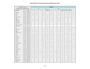
The situation with respect to data management and data communication capa-Existing data management and communication capabilitiesbilities is shown in adjacent table. None ofData Management /Communicationthe countries with the exception of Kenya,Uganda and Tanzania employ systematicdata storage and management tools formanaging the hydro-meteorological data.Only in few countries, for example in Ethiopia, Uganda, Tanzania telemetry systemhas been introduced to support near-realtime data transmission.History of hydrometricmonitoring stationsUganda is a typical example of the development in national hydrometric monitorng stations. Expansion took place in the1950’s and lasted up to 1970’s after which adecline took place. Presently the numbers seem rather stable, but this does notnecessarily reflect an output in terms of asteady flow of reliable data.The exception is Sudan, where measurement of river flow started as early as 1902.Over the years, there has been a generaldecline in the number of stations that arekept operational or added to the network.Graphs that show how the number ofstations evolved in the last several decadesare provided here for those countries forwhich reliable data have been obtained.It can be observed that the early 1950’sand 60’s exhibited expansion of themonitoring network as more and morestations were added. The late 1960’s andearly 1970’s showed considerable increasein number of stations due to partly theimplementation of the Hydromet projectthat was a collaboration project betweencountries: Egypt, DRC, Sudan, Uganda,Burundi, Rwanda.80 / Nile Basin Water Resources AtlasBurundiDR CongoEthiopiaCoop-data systemsNNNYNNNNNAuto-accessNNNNNNNNNNote: the Survey didn’t include Egypt”KenyaRwandaSouth SudanSudanTanzaniaUganda
current monitoring networkThe Main Nile Sub-basin: this sub-basinNile system for irrigation. In addition,includes parts of Sudan and Egypt andevaporation from the High Aswan andincludes, the Nile Delta, which is one ofMerowe dams account for about 13 – 14the most intensively cultivated lands in109m3 of water per year that is approxi-the world since millennia. The Main Nilemately 78 percent of all the evaporationsub-basin is the part of the Nile Basin,from man-made reservoirs basin-wide.which receives least amount of rainfall.With increasing water demands underHowever, on the other hand, this is theincreased climatic variability, it is crucialpart of Nile Basin which exhibits most ofto strengthen monitoring of water usethe consumptive water use. It accountspatterns and evapo-transpiration in thisfor approximately 80 percent of the totalpart of the Nile Basin.estimated water abstraction from thephoto: Vivian NabyongaThe Main Nile Sub-basinStream gaugeMeteorological monitoring networkin the map below. 11 stations are reportedHydrometric stationswater level and discharge. A new stationThere are 26 meteorological stations into measure the full range of meteorolog-There are 8 hydrometric stations inhas been established recently at MeroweSudan within the Main Nile sub-basin.ical parameters and the rest 7 measurethe sub-basin in Sudan. The number ofdam (commissioned in 2009).The distribution of the stations is showndaily rainfall totals only.stations in Egypt, i.e. downstream of thehilal-SMeteorological stationsTownRiverta'aTirTir'atan Nubariyyaiaailhml isCountry boundarytaaTirSubbasinThe NBI is not an authorityon international boundariesHigh Aswan Dam is not included in theMain issues that require strengthenedsurvey results. The oldest station, Mainmonitoring in this sub-basin are waterNile at Thamaniat was established in 1912quality deterioration, sediment load andand, hence, has over 100 years of records.sand encroachment and water loss throughThe ultimate downstream station beforeriver bank overflows. Dongola, Tamaniatthe Nile enters the High Aswan Dam is atand Hassanab stations are included in theDongola, which was established in 1923.Nile Basin Regional Hydromet NetworkThree stations, namely, Tamaniat, Dongo-with main strengthening required in sedi-la, measure sediment loads in addition toment and water quality monitoring.inMaNilTukh try boundarySub-basinThe NBI is not an authorityon international boundaries6waTukh CanalglalW.Kuom13bW. Habo9 27 1417EritreaiWadW. Shigrib8eKeh110262202122W. Moglal63W. OklissW. Abu DoWadi El MogadamW. UmmBahrdawaEl HalikAl MW. Habob2iWadiWadaturmW.KRabwa StationShaboolaSodariUm baderUm KaroamGoz AshgernaEritreaib212223242526atW. AwDamerStation no.6TuragmaZeidabAbu hamraHamrat AlsheikhKogmerTibW.14151617181920lEl HudeibaShambatEldamerGumaizaMerowe Dam Axis Left BankAlgozBaugarko78910111213aW. BwarWadi HaSudanName of StationAbu HammadEl ShowakDongolaKarimaShendiWadi Halfa5mKilometersNo123456muAWadi4Main NileEthiopiaW. Amun7W. Iotu HaBlue NileK. AbWhite Nile1Wadi El Hamad55raz2019250r23El Gu24Bahr El Gazalueimbu DK. AiliTekeze-Atbarawa1612dawaaEl H5W. Tibn18W.IotK. AuDW. KualikAl MW. AmuniWadiWadAmusW. Oklis11W. AbW.BarkoliWadWadi El HamadawarWadi HWadi El Mogadam4uDAbW. MoHarazbu110K.NileMain NileMainr3SudanW. ShigribiliuEl Gehedi KWa15EgyptmueiTekeze-AtbaraWhite NileBahr El Gazal055110Blue NileEthiopia220Kilometers12TamanyatBarbar34Merowe BridgeMerowe Dam Axis Downstream56Merowe Dam Axis UpstreamDongola7ElKuruNile Basin Water Resources Atlas / 81
The Tekeze–Atbara Sub-basinThe Tekeze-Atbara Sub-basin: thereaches. The long-term average annualin the sub-basin, the TK5 in EthiopiaTekeze-Atbara drains the highlands ofwater yield of the sub-basin is approxi-(commissioned in 2009), Khashm el Girbacentral – north Ethiopia. Its main riversmately 12 10 m3. The rivers are highlyin Sudan (commissioned in 1964) and theare the Tekeze (also known as Setit in itsseasonal in their flows. The rivers are usedAtbara dam complex (also known as Ru-lower reaches), Gwang and Atbara, whichto supply water for hydropower genera-mela-Burdana dam, not yet operational).constitutes the ultimate downstream rivertion and irrigation. There are three dams9BerberamhamiyK. To K. Ser K. AsotobitW. Mahaleit 143K. DeriKhor GuraEd DamireinK. Org139k.ebCountry boundaryEthiopia and 8 in Sudan. The distributionin the sub-basin, with 128 of them inSubbasinof the stations is shown in the map. 30The NBI is not an authorityon international boundariesKAdarotAtbaraThere are 136 meteorological stationsstations (26 in Ethiopia and 4 in Sudan)ebare reported to measure the full range ofdnardemeteorological parameters and the restderuDK.K. Umm SafaTekezeAtba106 measure daily rainfall totals only.K.raphoto: Nile-SECW. ArabK.K. AMain NileEigaikwatrabMeteorological monitoring networkMeteorological stationsTownRiverabAmWind 6140131Eritrea137129153147135K. G122New HalfaaratK. Mindia138it di KeyhSitonaTekeze-AtbaraMelgu146aidy 4Blue Nile100White Nile101 16547010514Gonder117aYimr9220078737289 1975KilometersbkwatK. SeK. DeriilgiW. HK. Orgeinebwater level with most stations employingmanual staff gauges while 8 stations in therivera RbmaaAtbK. Aupstream part are equipped with automat-K. TikridTekeze AtbaraK. MindiaK. GaratitMerebDekemhareelemAykTeseneyAdi KeyhSitona24nakutDuraTsaid2325222119Al QadarifKaza10 Goha12RahadEthiopiaJarma2GonderTirareBlue NileLake Tana100200Kilometers82 / Nile Basin Water Resources Atlas71Meri5098 Giba4Bera2601613Tekeze311iWere6Angereb5Blue NileUri14RuwasaMekezaAl HawataDindiment transport are key processes in thefuture demands. Therefore, coordinatedsub-basin but not adequately monitored.management of storage dams in EthiopiaYimraStrengthening sediment monitoring is oneand maximizing water use efficiency. Forof the key areas for improving the moni-this purpose, a real-time data collectiontoring system in the sub-basin.and communication system is required tosupport future coordinated managementThe rivers in this sub-basin are highlyof water storage dams in Ethiopia andseasonal and water resources are ebMelguTekeze AtbaraMayShuwakcompared to the current and anticipatedand Sudan would help in reducing losses,iverNew Halfaic water level recorders. Erosion and sed-EritreaRQashAromaKassalaWhite NileAsketemaDabo KetemaKulmeskMujaKassalaNew HalfaKhashm ElgirbaElshwakFireweiniShiraroTekeze Hydro powerWad alheleoAromaBanrtDegenGashm algerbaGoz RagabHadaliaHalfa rguBarbarDokaElGuraishShowakElazaza NorthEs salamaHillat HakumashasheinaUm brakeitUm GrgorUm RahauAykelthe mid 1970’s. All stations measure riverK. Umm 47148149150151152153154stations in Ethiopia were established afterrudeK. atDib BahirFelwuhaGedebeyeGobgobKimir DingayNegadebaherTikil DengayWelela aiAsegedeAynalemChilaDanshaDebudDengoletEdaga HamusEdagaribiEntichoFatsiGerehu ar Kilo 3 was established in 1923. MostThe NBI is not an authorityon international boundariesdebek. 11021031041051061071081091101111121131141151163 in Sudan. The oldest station, AtbararnaKhor GuraEd DamirAdiremetsAditsetserBadmeBiezetBoraDaro HafashDebrekerbeDeraDimmaEdaga SelusEdaga roHagere SelamHaleloHawzenHewaneKetema NegusMayhanesMerhsenayMuglatRahyaSelehelehe (IV)SememaShiraroWedisemroWukuroYichilaYihaAyna BugnaBelebala GiyorgisChillaDibikoEsrel (Libanos)Gibanasub-basin; 23 in Ethiopia and the 7677there are 26 hydrometric stations in theCountry BoundaryrobitW. MahaleitBerberK. AsotK. EigaiamiyamK. TohW. Arab104Name of StationDebarkHumeraMetemaSanjaAdwaAtsebiMay TsebriMaygabaNebeletSenkataShire EndasilasseAmde WorkLalibelaTsitsikaAxum Air PortMekele Air PortAdi ArkayAgere GenetAmbagiorgisAshereBaekerBelesa (Hamusit)ChanchokChenekChew BerEbinatEndrisGuhalaIbnatKaftaMykadraMekane BirhaneTegdie (Kirakir)Abi AdiAdiawalaAdigoshuAdikilteAdimehemedayHydrometric stationsHydrometeorologicalStationTownRiverK. AraMain Nile4666999 11256Giba52872850115106125 1055a12722011634 53h 982432Lake Go852571 10844481EthiopiaBlue 65 8115039Ange10266100Du3717Al Hawata113 5794tanrku 61302114911012667Gereb15036a151Al ndawoha near KokitAtsela near AdishihuGoang near MetemaAsera near DebarkAl AsiraTekeze near YechilaMetere near Ainalem89101112131415Gheba near Adi KumsiDolo near QuihaBuya near MaitsemriIllala near MekeleMekezo near DanshaGheba near MekeleTekeze near EmbamadreAngareb near Abdi RafiGenfel at WukroWorie near MaikenetalSulluh near HawsienAyehida near AxumMaimidimar near AdwaSebtta near AdidahiroMaidungur near AdwaHamdait24 Tekeze at Humera25 Molge near Shiraro26 Zarema at Zarema
The Blue Nile Sub-basinThe Blue Nile river (known as Abbay inmately 50 BCM. The Blue Nile is highlyfrom time to time. The Grand Ethiopi-releases from the dam. This is expected toEthiopia) drains the highlands of Ethiopiaseasonal with approximately 70 percent ofan Renaissance Dam (GERD) is underreduce flood damages significantly. Thereand contributes about 60 per cent of theits annual flow occurring in just 4 months.construction on the Blue Nile designed toare opportunities for cross border collabo-annual flow of the Nile measured at AswanThe Blue Nile is source of water for majorstore some 74 109m3. With the GERD inration on the coordinated management ofin Egypt. The long-term average annualirrigation schemes in the Sudan. The Blueplace, the Blue Nile will be fully regulat-the Blue Nile in which joint monitoring ofwater yield of the sub-basin is approxi-Nile causes severe flood damages in Sudaned and its downstream flow depends onriver flows is an important component.Meteorological monitoring networkstations (53 in Ethiopia and 11 in Sudan)Hydrometric stationsproviding over 60 percent of the averageThere are 304 meteorological stations inare reported to measure the full range ofThere are 133 hydrometric stations inannual flow of the Nile, the Blue Nile isthe sub-basin, with 286 of them in Ethio-meteorological parameters and the restthe sub-basin; 126 in Ethiopia and thethe major source of water for the Nile. Keypia and 18 in Sudan. The distribution of106 measure daily rainfall totals only.remaining seven in Sudan. The station justfocus in strengthening of hydrometricthe stations is shown in the map below. 64downstream of Ethiopia – Sudan border,the Diem station, has a record of overMain NileAbuSanaEthiopia were established in the early311Tekeze Atbara304 322313314305286279312291316dR297ElAqanot adequately monitored.data collection and transmission 347464414472rde37142432Lake Tana151The Blue Nile sub-basin offers one of theriver morphological changes downstreamgreatest opportunities for hydropower de-as a result of anticipated flow regimes invelopment in the Nile Basin. In addition,the sub-basin.4151 4232326212145265147 145 5082131139148195Jita 138 257141193 16070611253538Nil173 140 14912873e48182136 26778826027674154 18875146134288178132273 2701521483 12327164 805366159171les33e1222685616855 13B2612646871126259174189 164 187 186 18313552272124172175 692587 156181180129167 16611729079 170Ch58 17934 26362 165274 130153 163e157 76 67ye910 191 60361046137224 2871691271844 185 559269 133158115719054eka 5300233Wenc 244 2993es237249 106a92 21696 20 acha2111411524894Muger 101236235247110217 2462262752831241218 90 54 2382222421032212720025121323915Baro 198199 84 207196197203202 2102018516212 205 2082048687206209 211131r)BeshiloAlbedaMain NileK. AbSub-basinu TableNiub W. Abu aRiverCountry boundaryueBlEthiopiaBlue NileTekeze Atbara285deDina(KoliMitisBluerhin281White NileRiveK.monitoring system shall be on real-timesediment monitoring and monitoring of310dirDinriaWhite NileaK. El G293are also key processes in the sub-basin but303ive299anan277Ground water level monitoring station320ElRahaeK. K296 Dinder292298321dhaRa3063073173183023151960’s. Erosion and sediment transportK.AbuSanaK.130The NBI is not an authorityon international boundariesFinchaTekeze AtbaraGuderSouth 5916016116216316416516616716816997 969286Blue Nile71624540433930 34South SudanDilaFincha5046353327u286 Singa287 Cheffa288 Simada289 Yetenora290 Sher. Gizen (W)291 Dendar292 Dender293 Karkoj294 Kassab295 Sennar Town296 Singa297 Tozi298 Ubhugar299 Wad Alneal300 Abu Kshma301 Abu Sharaba302 Almatna303 Kagai304 Leiya305 Hugerat306 Rabak307 Ummsigan308 Wad En Na’em309 Wd Alkali310 Basunda311 Elfaw312 Elhawata313 G.enahal314 Gadamblyia315 Mafaza316 W.eshaair317 Elhory318 Elmetna319 GadamblyiaSouth320 Samsam321 Um Blail322 Um Leiyon323 Debre Taboron228 Muke Turi229 Seladingai230 Serkulla231 Shekute232 Toke Erenso233 Wegere234 Zemro235 Agallo Mitti236 Amba 10237 Amba 16238 Arbgebeya239 Dedessa River240 Ehud Gebeya241 Gebete242 Getema243 Gizen244 Haro245 Homi246 Jarso247 Jermet248 Kiltukara249 Kiramu250 Kokeffe251 Kone252 Menge253 Mukelemi254 Muletadiga255 Sasiga256 Werejiru257 Ajibar (Add)258 Akesta259 Ancharo260 Dawunt (Chet)261 Dessie Zuria Met262 Estayish263 Genete Sch264 Gerado265 Geregera266 Gobiye267 Gosh-Meda268 Kelem Meda269 Kellela270 Kundi271 Kutaber272 Tebasit273 Tenta Tateke Sch274 Wein-Amba275 Hena276 Teleyayen277 Abu Naama278 Sennar279 Umm Benin280 Wad Medani281 Ed Damazine282 Khartoum283 El Gadaref284 Elgezira285 RoseiresAn170 Gimijabet Mariam171 Gulback172 Gundo Woin173 Kembaba174 Keranio175 Kessa176 Kuy177 Lumamme178 Mambuk179 Mankusa180 Menta Wuha181 Merto Lemariam182 Meshenti183 Quarit184 Rob Gebeya185 Sebader186 Sekela187 Tilili188 Tis Abay189 Urana190 Wadeyesus191 Yechereka192 Yejube193 Yesemala194 Yetnora195 Zenzelema196 Abdela197 Bido198 Debena199 Gechi200 Kone201 Setema202 Yambero203 Yanfa204 Babu205 Boto206 Choche207 Dame208 Gembe209 Semodo210 Setema211 Somodo212 Toba213 Arb Bila214 Chacha215 Debre Tsige216 Degem217 Deneba218 Enchini219 Fetra220 Fital221 Gimbi Bila222 Gubre223 Harodoyo224 Jara225 Jihur226 Kotu227 MugerDabusMendiNeshiOdda BildiguluSherekoleSibusireUkeWayuDebre ZebitDebre ZeitDegolloDensaGashenaGimbaGishe RabelGishenGuguftuKabieKoneKorebLigwamaMashaSaynt AdjibarShogaWegidiKon AboAmbesameArb Gebeya(Dera)Arb Gebeya(Gaint)AymbaChewahitDelgiDera HamusiteKoma FasiledosKorataLewayeLichaShembekitYifagAbay ShelekoAddis AlemAndassaAneded (Amber)AskunaAzanaBarudaCharaChimbaDebre ZeitDejenDibateEnjabaraFelege BerhanFeres Dengay BerDengel BerDigua awiShandiShebelberenta(Yeduha)SimadaWegedadeWetet AbayYetemenZegeZela iliklikGebere derShenoSiadebrSulultaTikur EnchineAbadiAbasina Hareto118117116114Jita108 110113112107109111ilo106Besh103 104 1059895 78767072696574666768 6459 606163Weleka57hit 55 5258cn56We514953 5447aemJ4448Chacha41erng42MugHa3837er3631293224 2526282322192018 161421131797 1285611 yehuBirr ShelekoBullenChagniDangilaDebre WorkFinoteselamLay BirrMankushMottaPaweBedeleGatiraAlem KetemaAmbo AgricultureDebre BerhanEnewareFicheGunde MeskelKachiseMehal ShambuAmba MariamMekane SelamWegel TenaWereiluGondar A.p.Bahir Dar NewDebre MarkosNekemteAddis ZemenAmed susShinfaWanzayeWereta (Add)Addis aBaroBaro-Akobo-Sobat43esaDid2 839404142434445464748495051525354555657124123Tana 120BelesMitisWhite eRiveK.diraria140RahadugZitaNilenaK. KK. El GWhite Nile70adna35DinBluebePibor0bohRa127Baro Akobbo 9295294278back-water of the dam. Most stations inadaK.etTaroba284the station at times get inundated by theThe NBI is not an authorityon international boundariesEt TamleNiW. Abu QanafidK.308heightening of the Roseries Dam in Sudan,Subbasinphoto: Nile-SECEt TamadaueBluTab309important. However, is due to the recentEritreaCountry boundarybbuK. A100 years and, therefore, one of the mostMeteorological 617181920212223242526272829StationUrgessa near GembeTemsa near AgaroDidessa near DembiDabana nearBunobedeleDidessa near ArjoWama near NekemteMelke near GuderSifa near NekemteBello near GuderFatto near GuderIndris at GuderGuder at GuderHuluka near AmboDebis nearGuderDabana near AbasinaTato near GutieIndris near SireAdiya near NekemteGerbi near SulultaRoba near ChanchoDeneba near ChanchoMugher near ChanchoUke near NekemteAleltu near ChanchoGorfo near GorfoAngar near NekemteDilla near NedjoTinshu Duber nearDuberTilku Duber near Duber30 Aleltu at Nedjo31 Little Ang at AngarGutin32 Chacha at Chacha33 Komis near Gori34 Koriche near Kiltu Kara35 Hujur near Nedjo36 Robi Jida near MukaTure37 Aleltu near Muka Ture38 Beressa near DebreBerhan39 Sechi nearMendi40 Mutsa near Bambasi41 Neshi near Shambo42 Robigumero near Lemi43 Dabus near Asosa44 Jemma near Lemi45 Haffa near Assosa46 Gambella near Asossa47 Jemma at AbayConfluence48 Abay at Kessi Bridge49 Wenchit near AlemKetema50 Hoha near Asossa51 Muga near Dejen52 Wizer near Mehal Meda53 Yeda near Amber54 Bogena at Lumame55 Shy near Mehal Meda56 Chemoga nearDebremarkos57 Abahim atDebremarcos58 Jedeb near Ama Nuel59 Teme near Mota60 Suha near Bichena61 Gebregura. nearDegolo62 Shelkole nearKomosha63 L. Fettam at Galibed64 Temcha nearDembecha65 Gudla at Dembecha66 Jogola at Wereilu67 Abbay near Bure68 Chereka at Yechereka69 Birr near Jiga70 Leza near Jiga71 Abay at ShergoleCableway RGS72 Lah near Finot
ly, Uganda has the largest groundwater observation network that includes 30 groundwater monitoring stations. NBI countries, hydrometric stations summary Country Hydrometric stations Country Hydrometric stations Burundi 15 Sudan 18 Kagera 15 Blue Nile - Lower 7 DR Congo 0 Main Nile 8 Lake Albert 0 Tekeze-Atbara 3 Ethiopia 176 White Nile 0