Transcription
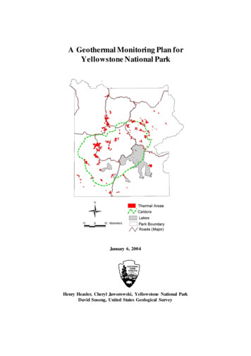
A Geothermal Monitoring Plan forYellowstone National ParkJanuary 6, 2004Henry Heasler, Cheryl Jaworowski, Yellowstone National ParkDavid Susong, United States Geological Survey
TABLE OF CONTENTSEXECUTIVE SUMMARY . . . 1INTRODUCTION . . . . 2GEOTHER MAL MONITORING PLAN COMPONENTS . . 2Groundwater Inventory, Monitoring and Assessment . .2Objectives . . . 2Hydrologic Regime . . . 3Well Locations . . . 3Establishment of a Monitoring Network. . 4Site Selection . . . 4Groundwater Data Collection . . .5Groundwater Data Analysis . . .5Chloride Flux Inventory, Monitoring and Assessment . .6Introduction . . . 6Objectives . . . 7Streamflow Gauging Station Installation and Operation . 7Chloride Sample Collection, Analysis, and Flux Calculation . 7Chloride Flux Data Analysis. . .7Individual Thermal Feature Inventory, Monitoring and Assessment . 9Introduction . . . 9Methodology . . . 9Remote Sensing of Hydrothermal FeaturesIntroduction and Objectives . . .10Mapping Historic Changes in Thermal Areas . .10Image Selection . . . 11Remote Sensing Deliverables . . 12Yellowstone Geothermal Database . . 13Introduction . . . 13Methodology . . . 13BUDGET . . . . 14REFERENCES . . . . 15APPENDIX A - Legal Mandates and Authorities . . 19APPENDIX B - Individual Thermal Feature Assessment Methodology . 20
EXECUTIVE SUMMARYProtection of Yellowstone’s unique geothermal features is a critical mission ofYellowstone National Park (YNP). Yellowstone is required to protect its geothermalfeatures from external threats such as those posed by geothermal development both inIdaho (Island Park Known Geothermal Resource Area) and Montana (Corwin SpringsKnown Geothermal Resource Area). Other threats include oil, gas, and groundwaterdevelopment in Wyoming, Montana, and Idaho. The proposed geothermal monitoringplan presents a program designed to systematically gather hydrologic, geochemical,remote sensing, and geologic information to meet YNP’s legally mandated geothermalmonitoring and protection requirements.This proposal will complement monitoring of the Controlled Groundwater Area inMontana adjacent to the park by the Montana Bureau of Mines and Geology throughmonitoring the water resources within the park, including both cold groundwater andthermal water.Funding is requested for five components of YNP’s Geothermal Monitoring Plan:1. Groundwater inventory, monitoring and assessmentThis component assesses Yellowstone’s hot and cold groundwater resources anddevelops a long-term data set to detect natural and anthropogenic changes to thegroundwater system.2. Chloride flux inventory, monitoring and assessmentThe chloride flux program monitors overall changes in the amount of chloride exitingvarious sections of the park. Because chloride in Yellowst one is predominately froma magmatic source and is conserved in water, chloride can be used as a proxy for heatflux and geothermal activity and can be used to monitor natural and anthropogenicchanges to the geothermal system.3. Individual thermal feature inventory, monitoring and assessmentMonitoring of specific thermal features and thermal areas provide information onnatural and anthropogenic changes in the pathways of thermal waters between areasboth inside and outside the park.4. Remote sensing of hydrotherm al featuresThe large number, complexity and rapid change of thermal features in the Park makeinventory and change assessment difficult. Remote sensing provides an effectivemethod to inventory, monitor, and assess historic and ongoing changes inYellowstone’s thermal features. Satellite and airborne imagery will be used toprovide maps of thermal areas of the entire park that will quantify changes in thermalareas through time.5. Information transfer using the Yellowstone Geothermal DatabaseInformation gathered as part of this plan will be stored and disseminated using anInternet-based Geographic Information System with links to the YellowstoneControlled Groundwater Area data on the Internet. Coordination betweenYellowstone National Park and the Montana Technical Oversight Committee will beaccomplished through continued annual meetings to review data and activities.BudgetThe proposed budget for the five components is 846,400 (first year), 841,600(second year), and 839,000 (third year) with funding continuing in perpetuit y.A Geothermal Monitoring Plan for Yellowstone National Park1
INTRODUCTIONWhen the first exploring parties surveyed the Yellowstone region in the late 19thCentury, it was the geologic wonders - geysers, hot springs, mudpots, fumaroles - thatcaptured their imaginations. Because of these treasures, the U.S. Congress set aside anddedicated this land of “natural curiosities” as the world’s first “public pleasuring ground”.Protection of Yellowstone’s unique geothermal features is a key mission ofYellowstone National Park (YNP). This mission is challenging due to a variety of threatsposed by widely disparate mechanisms. Yellowstone is required by law (see AppendixA) to protect its geothermal features from external threats such as those posed bygeothermal development both in Idaho (Island Park Known Geothermal Resource Area)and Montana (Corwin Springs Known Geothermal Resource Area). Other externalthreats include oil, gas, and groundwater development (in Wyoming, Montana, andIdaho).In 1994, the State of Montana and the National Park Service established a waterrights compact and controlled groundwater monitoring program within Montana adjacentto Yellowstone National Park. The purpose of the compact is to protect Yellowstone’sunique geothermal resources from groundwater or geothermal development that mightoccur within Montana adjacent to Yellowstone National Park. The inventory andmonitoring of Yellowstone’s geothermal features is a necessity for the success of theMontana Compact and will complement monitoring activities undertaken separately byMontana State agencies under the direction of the Compact.In order to protect Yellowstone from the adverse effects of development inadjacent communities, we must have knowledge of the undisturbed state of its thermalfeatures. However these features change over time in response to various processes. Forexample, the conduits feeding these features can be filled with chemical deposits. Theseconduits can also be sealed or opened by earthquakes, so that the thermal fluid flow pathschange in time naturally. In addition to these localized changes, large-scale changes inthe supply of thermal water from the magma beneath the park can occur. Yellowstone’sgeothermal system is very dynamic, and changes occur on time scale of days to years.Monitoring these changes will provide important context for assessment of humaninduced threats from outside the park. Such monitoring data are essential both inside andoutside the Park. In order to secure a database of the geothermal system, it is necessaryto use various monitoring techniques and to observe the system over many years.Coordination between Yellowstone National Park and the Montana Compact TechnicalOversight CommitteeIn order to continue coordinat ion of the geothermal monitoring activities of theState of Montana under the Controlled Groundwater Area of the Montana Compact withthat of Yellowstone National Park, the annual meetings between representatives of theTechnical Oversight Committee of the Controlled Groundwater Area, Montana Compact,and Park personnel will continue.A Geothermal Monitoring Plan for Yellowstone National Park2
GEOTHERMAL MONITORING COMPONENTSGroundwater Inventory, Monitoring and AssessmentObjectivesThe objective of groundwater assessment in YNP is to collect basic datanecessary to analyze short and long-term changes to Yellowstone’s geothermal systemsand to understand the interaction between cold groundwater and the geothermal systems.Analysis of the data will improve the understanding of Yellowstone geothermal andgeothermal systems and will complement monitoring undertaken as part of the MontanaCompact in lands adjacent to Yellowstone for the long-term protection of Yellowstone’sgeothermal systems.Other components of this proposal will assess individual geothermal features andtheir extent and distribution as well as the measurement of the gross heat flux from thegeothermal system with the chloride flux-monitoring program. In addition, water levelrecords may be used to evaluate deformation and seismic events within the YellowstoneCaldera (Hamilton, 1987).Without these data it is not possible to investigate the interaction between coldgroundwater systems and geothermal systems and to separate seasonal or anthropogenicchanges from long-term fundamental changes in the geothermal system.Hydrologic RegimeGroundwater in YNP is found in a diverse variety of aquifers. Shallow alluvialand glacial aquifers are found throughout the park usually associated with streams, riverchannels and valleys. Volcanic aquifers composed of fractured rhyolite and basalt flowsare found in the central, western and southern parts of the park while andesitic volcanicunits are found in the eastern and northeastern parts of the park. The Madison Aquifersystem is present in and adjacent to the park and has been identified as an important partof the groundwater flow system associated with Mammoth Hot Springs. The MadisonAquifer system connects coldwater inside and outside the park to thermal features withinthe park. The Madison aquifer system forms one of the foundations for boundarydelineations in the Yellowstone Controlled Ground Water Area (Custer et al, 1993).These aquifers are loosely grouped and referred to as “cold water” aquifers.High temperature geothermal fluids associated with magma bodies beneath andnear the Yellowstone Caldera are the other major component of the groundwater systemin Yellowstone. Geothermal fluids are convected toward the surface in fracture systemsthat are self-sealing and tectonically sensitive, which results in frequent changes to theflow system. Waters from the “cold” aquifers are part of the hydrothermal flow systemwhich is heated and discharged in geothermal features throughout Yellowstone Park.The heated water may also mix with cold water locally. Fournier hypothesizes thatannual, generally widespread changes in thermal features in the Norris Geyser Basin arethe result of changes in the potentiometric surface of cold water adjacent to orinterconnected with the geothermal system (Fournier and others 2002). In order tounderstand short-term cyclical, catastrophic changes as well as long-term, natural oranthropogenic changes to the Yellowstone geothermal system, both cold groundwaterand geothermal systems must be monitored and assessed.A Geothermal Monitoring Plan for Yellowstone National Park3
Well LocationsThere are three general categories of wells in YNP: 1) water supply, 2)groundwater monitoring usually associated with sewage treatment plants, lagoons andabandoned landfills, and 3) research wells. Most water supply wells and groundwatermonitoring wells are completed in valley fill or alluvium, are shallow ( 30 m) andgenerally located near park infrastructure - visitor centers, hotels and maintenancefacilities. Groundwater monitoring wells are located around sewage treatment plants,underground storage tanks or landfills. A number of old landfills within YNP havemonitoring wells around them. From the well records compiled to date there are noknown wells completed in any of the volcanic aquifers. Additional well data need to becompiled for many of the wells in the data set including measuring ground elevations,water levels, perforated intervals, well logs, field parameters (water temperature, pH andspecific conductance). Historic data for many of these wells are located in variousoffices within Yellowstone and need to be compiled into a single database. Monitoringof wells is important if pressures exerted by cold-water in thermal areas does controlthermal water discharge.There have been 15 high-temperature research wells drilled in Yellowstonestarting with the Carnegie wells in the Norris Geyser Basin drilled in 1931 (Fenner, 1936;White and others, 1975). The U.S. Geological Survey drilled 13 research wells in the late1960’s (White and others, 1975). These wells were drilled in or near the Old Faithful,Norris Geyser Basin, the Mud Volcano and Mammoth thermal areas. Many of these wellshave deteriorated because of high temperature/pressure/acidity of geothermal fluids. Mostof the USGS research wells were plugged with the exception of Y-7 at Old Faithful andY-10 at Mammoth. A well drilled as a water supply well at the South Entrance of YNPalso has elevated water temperatures. Other research wells drilled in the park aregenerally not associated with the geothermal system and have been drilled to study andmonitor wetlands. These wells are generally very shallow ( 6 m).Cox (1976) inventoried many of the wells in YNP. New supply and monitoringwells have been drilled since Cox’s study. An updated inventory of wells drilled in YNPwas completed in summer of 2002 by YNP’s Spatial Analyses Center. Records of 170wells and springs were compiled. This inventory of wells includes springs used in thepark for water supply. Of these 170 wells, 50 could not be found when field checked orhad been abandoned or plugged.Establishment of a Monitoring NetworkThe groundwater monitoring well network proposed for Yellowstone will be ahierarchically nested network design (Klusman and Chappell, 1980). In this type ofmonitoring network, data are collected from sampling sites at different intensities, bothspatially and temporally, with the objective of optimizing the amount of data collectedwhile minimizing the cost. Areas where the most variance in the data is expected will bemonitored more intensely.There will be three types of sites with different levels of data collection intensity.Level 1 sites will have continuous water level and temperature recorders, and waterquality samples will be collected quarterly. Water levels and temperature will becollected at a minimum of 15-minute intervals. Level 2 sites will have continuous waterA Geothermal Monitoring Plan for Yellowstone National Park4
level and temperature recorders sampling at hourly intervals and water-quality samplescollected annually.Level 3 sites will have annual water-level and field water measurements. Theobjective of Level 3 sites is to develop a long-term record of annual changes in waterlevels and water quality and to do this over the widest area possible. Level 3 sites will bemeasured at the same time each year so that the annual values will be comparable. Inadditional, all Level 3 sites will be sampled once to analyze for complete water chemistryto establish a large baseline data set. Twenty wells will be selected for level 1 and level 2monitoring. Up to 50 wells will be selected for level 3 monitoring.Site SelectionSites will be selected that are representative of the various aquifers andthroughout the Park. There are two distinct climates within YNP (Despain, 1987) andYNP is located near the boundary between regional atmospheric flow patterns.Depending upon the location of this boundary, the annual climate and precipitation maybe above or below normal. Water levels will respond to annual climate variations and themonitoring network will provide information regarding the amount and timing ofresponse.Wells will be selected near Old Faithful geyser basin, Norris geyser basin, andMammoth terraces that are completed in alluvial aquifers. These cold water aquifers maymix or interact with the geothermal waters and thus are important to monitor. Additionalcold-water wells will be selected in outlying areas of the Park to fill in the spatialdistribution. These wells will be monitored as level 2 or level 3 wellsThe two high temperature wells (Y-7 at Biscuit Basin and Y-10 at MammothTerraces ) that remain will be monitored with continuous recorders for water level andtemperature as Level 1 sites. Multiple temperature probes may be deployed to measuretemperature gradients. Water quality samples will be collected quarterly at a minimumand possibly monthly in conjunction with other park monitoring efforts projects. The wellat the South Entrance with elevated temperatures will be monitored as a level 2 well.Existing water-quality monitoring programs will augment the groundwater monitoring network proposed here for public water supply wells and springs and forgroundwater monitoring wells associated with sewage treatment facilities and landfills.There are about 50 groundwater monitoring wells and many are sampled annually.Current and historic data from wells that are regularly sampled will be compiled. Datacollected under these programs will be included in the Yellowstone GeothermalDatabase.Groundwater Data CollectionAll data collection will be done under the same standard operating procedures(SOP). A SOP will be prepared that will cover the use and calibration of fieldinstrumentation, well pumping, sample collection and handling, sample login andshipment. The SOP will receive outside agency review prior to the start of monitoring.Each of the site types will have a different sampling protocol, which will be listed in theSOP. Field parameters (temperature, field pH and specific conductance, and waterlevels) will be collected at all sites. Water samples collected from Level 1 sites will beanalyzed for stable isotopes (deuterium, 18-oxygen, and tritium) and common ions andA Geothermal Monitoring Plan for Yellowstone National Park5
trace metals. Samples collected from Level 2 sites will be analyzed for stable isotopesand common ions and Level 3 site samples will be analyzed for field parameters. All theLevel 3 sites may be sampled once for stable isotopes, common ions and trace metals toestablish baseline conditions. A quality assurance plan will be written for thegroundwater -monitoring program to insure the long-term quality and integrity of the data.The plan will describe the types of quality assurance, quality control samples (spike,blanks, equipment blanks, duplicates) and the frequency of submission. The plan willalso document the procedures and statistical methods for analysis of the control samplesand establish data flags for noting data that fall outside of control criteria.Groundwater Data AnalysisData will be compiled and analyzed in an annual report. The report will beavailable electronically on the Internet. All data will be visually inspected and plotted.Maps of water level elevations, water temperature, pH and specific conductance will beprepared along with graphs for each parameter for each well. These graphs will beannually updated and trends analyzed. If on visual inspection of the data any large orunexpected changes occur, further analysis of additional constituents will be requiredincluding analysis of surface water, groundwater and thermal features at nearby sites.Chloride Flux Inventory, Monitoring and AssessmentIntroductionChloride (Cl) is a widely distributed element in the earth’s crust and is conservedin water. Approximately 94% of the chloride in surface waters originates from themagma beneath Yellowstone (Norton and Friedman, 1985). Because chloride inYellowstone is predominantly from a magmatic source and is conservative in water,chloride can be used as a proxy measure of heat flux and geothermal activity (Fournierand others, 1976; Norton and Friedman, 1985). Long-term changes in Cl flux areindicative of long term changes in the heat flux from the Yellowstone geothermal systemand can be used to assess the impacts of proposed geothermal energy, oil , gas, andgroundwater development adjacent to the park. Variations in chloride flux are also usedto estimate groundwater recharge, to assess the effects of earthquakes, and other tectonicevents on the geothermal system. The use of chloride flux for estimating heat flux andgeothermal activity in YNP has been extensively published (Ellis and Wilson, 1955;Fournier and others, 1976; Norton and Friedman, 1985; Friedman and Norton, 1990;Norton and Friedman, 1991; and Friedman and others, 1993; Friedman and Norton, inpress).The chloride flux from Yellowstone has been measured for 19 years inYellowstone's major rivers - the Fall, Madison, Snake, and Yellowstone Rivers. It is theonly long-term data set available for monitoring changes in the Yellowstone geothermalsystem (Friedman and Norton, in press).The sum of the annual chloride fluxes for the four rivers varies as much as 20%year-to-year. This sum, when corrected for climatic factors, shows a decline of 10% overthe past 19 years. A decline in thermal flux from Mammoth Hot Springs has also beennoted, as has a lengthening in the period between eruptions of Old Faithful Geyser. TheseA Geothermal Monitoring Plan for Yellowstone National Park6
changes may be related to deflation of the Yellowstone caldera documented by changesin ground levels surrounding Yellowstone Lake (Friedman and Norton, in press).ObjectivesThis Geothermal Monitoring Plan seeks to continue and to improve the resolutionof the existing chloride flux program in YNP by adding eight new streamflow gaugingstations to the existing streamflow monitoring network. The locations of all gaugingstations, both those already established and those proposed, are shown in Figure 1. Thepropsed new gauging stations are:: Tantalus Creek near the confluence with the GibbonRiver, the Firehole River between the Upper and Middle Geyser Basins, the FireholeRiver between the Middle and Lower Geyser Basins, the Yellowstone River downstreamfrom the Mud Volcano thermal area, the Yellowstone River near it entry to YellowstoneLake, and at three locations in the Bechler region of southwestern YNP. The addition ofthese new gauging stations improves the descretization of the Cl flux monitoring, willallow the quantification of thermal activity (heat flux) in four significant thermal basinsof YNP and helps assess long term changes in these basins whether natural oranthropogenic .Streamflow Gauging Station Installation and OperationNew streamflow gauging stations will be installed and operated by the U.SGeological Survey (USGS) and as part of the USGS National Stream-Gauging Program(Wahl and others, 1995). Data will be collected in near real-time and will be available onthe Internet. The location of the eight new river gauging stations (Figure 1) will bechosen in conjunction with the U. S. Geological Survey, Water Resources Division,Montana District Office. These automated stations will provide temperature, river flow,and gauge heights via telemetered data available real-time on the Internet.Chloride Sample Collection, Analysis, and Flux CalculationWater samples for chloride analysis are collected 28 times a year at river gaugingstations: monthly during the winter at low flow, biweekly during the early spring and fall,and weekly during spring runoff (Friedman and Norton, 1990). Samples will be analyzedby the USGS Yellowstone Volcano Observatory laboratory in Menlo Park, California.Instantaneous chloride flux is calculated from the measured chloride concentrati ons andthe discharge. The instantaneous chloride flux is integrated to provide annual chlorideflux (Norton and Friedman, 1985; Friedman and Norton, 1991, Friedman and Norton, inpress).Chloride Flux Data AnalysisData will be compiled and analyzed in an annual report. The report will beavailable electronically on the Internet. Chloride measurements and chloride fluxcalculations will be listed in tabular format along with graphs of chloride flux versus timefor each gauging site. These graphs will be annually updated and trends analyzed.Chloride concentration and chloride-flux data will be incorporated into the YellowstoneGeothermal Database.A Geothermal Monitoring Plan for Yellowstone National Park7
Figure 1. Current and proposed US Geological survey streamflow gauging stations.A Geothermal Monitoring Plan for Yellowstone National Park8
Individual Thermal Feature Inventory, Monitoring, and AssessmentIntroductionHistorically, the monitoring of individual thermal features has been the primarymethod for determining change in Yellowstone’s geothermal systems. Individual thermalfeatures, whether a geyser, hot spring or fumarole, are dynamic features, which regularlyexperience gradual and/or catastrophic changes. The quantification and assessment ofchanges to an individual thermal feature are difficult because a variety mechanismsmaybe responsible for change. Changes in thermal feature activity, discharge, or heat fluxmay be the result of seismicity, self-sealing of fractures feeding the feature, changes inhydraulic head of groundwater system, or vent plugging from human activity. Overall,the objective of monitoring individual thermal features is to document the diversity ofgeothermal features, their baseline conditions, and activities and behavior throughout thepark. Specific features will also be monitored with the focused objective of establishingbaseline data to document natural variability and provide context for assessing humanimpacts within and adjacent to the park.Another challenge facing the Thermal Feature Geochemistry and Extent programis the shear number of individual thermal features in YNP. Over 7,000 individual thermalfeatures have been inventoried over the last four years by YNP’s Spatial Analysis Center.Only 60% to 70% of the park has been inventoried. Thus, only a small subset of thermalfeatures can be monitored due budget constraint s.Previous inventories and monitoring of individual thermal features inYellowstone has been done on an adhoc basis and qualitative manner. Thermal activity(eruptions of geysers, changes in hot spring pools size, color or discharge) in majorgeyser basins were noted by park personnel in internal reports and documents. Detailedqualitative surveys of backcountry thermal areas have been conducted as time andstaffing allow. These surveys are important contributions for in many cases they are theonly documented record of thermal activity over time in these areas. Data collected onthese surveys largely are preserved in YNP archives in internal reports and notebooks.MethodologyMonitoring individual thermal features will utilize a multifaceted phasedapproach. This monitoring program will be labor and data intensive. The sampling anddata handling protocols will be written, pilot tested and reviewed before fullimplementation. A partial list of parameters that can be measured include temperature,flow, chemistry of water and gases (major anions, cations, metals, trace elements,isotopes, etc.), and spatial extent using techniques such as photographic surveyingmethods. Equipment used to take many of these measurements is expensive and requiresexpertise to operate, and will likely have a short life due to the aggressive water beinganalyzed. Sampling and analytical protocols as outlined by Hinman (2001) will beutilized. Not all aspects of the proposed thermal feature monitoring program can beaccompli shed with the proposed budget. Instead, components will be implementedthrough time. See appendix B for a discussion of the proposed methodology.A Geothermal Monitoring Plan for Yellowstone National Park9
Remote Sensing of Hydrothermal FeaturesIntroduction and ObjectivesRemote sensing of thermal features with various satellite and airborne sensors iscritical to monitoring Yellowstone’s geothermal resources. Geyser basins containnumerous individual thermal features that are widely dispersed throughout YNP,including remote, rarely visited backcountry areas. It is extremely difficult for parkpersonnel to visit and monitor all the thermal areas on an annual basis to assess change.Remotely sensed satellite and airborne imagery provides data to synoptically monitor andefficiently assess annual changes in geothermal activity for the entire park. The remotesensing component of the Geothermal Monitoring Plan will ass
A Geothermal Monitoring Plan for Yellowstone National Park 4 Well Locations There are three general categories of wells in YNP: 1) water supply, 2) groundwater monitoring usually associated with sewage treatment plants, lagoons and abandoned landfills, and 3) research wells. Most water supply wells and groundwater