Transcription
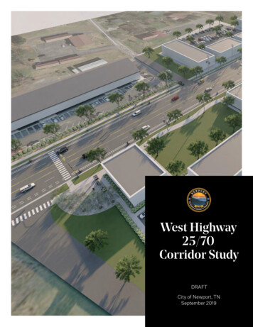
West Highway25/70Corridor StudyDRAFTCity of Newport, TNSeptember 2019
Prepared byFunded through the CommunityTransportation Planning Grant Program
ContentsIntroduction. . . . . . . . . . . . . . . . . . . . . . . . . . . . . . . . . . . . . . . . . . . . . . . . . . . . . . . . . . . . . . . . 1Section 1.0 Overview. . . . . . . . . . . . . . . . . . . . . . . . . . . . . . . . . . . . . . . . . . . . . . . . . . . . . . 2Section 2.0 Issues & Opportunities. . . . . . . . . . . . . . . . . . . . . . . . . . . . . . . . . . . . . . . . . 4Section 3.0 Development & Evaluation of Alternatives. . . . . . . . . . . . . . . . . . . . . . 10Section 4.0 Recommendations . . . . . . . . . . . . . . . . . . . . . . . . . . . . . . . . . . . . . . . . . . . 16Section 5.0 Implementation . . . . . . . . . . . . . . . . . . . . . . . . . . . . . . . . . . . . . . . . . . . . . . 28
CITY OF NEWPORT, TNWest Highway 25/70Corridor StudyThe Tennessee Department of Transportation (TDOT) established theCommunity Transportation Planning Grant (CTPG) program to assistTennessee’s small and rural communities in developing transportationplans to address transportation, land use, and growth managementissues. The program is designed to better integrate multimodaltransportation systems with local land use objectives and achievestatewide transportation goals.The City of Newport is one of the grant recipients during the CTPGprogram’s 2018-2019 grant cycle. This report documents the findingsand recommendations of the City of Newport’s West Highway 25/70Corridor Study.West Highway 25/70 Corridor Study DRAFT 1
Section 1.0OverviewWest Highway 25/70 (Figure 1), which runs east to west through the City ofNewport and Cocke County, is a crossroads of regional connectivity in EastTennessee. The highway currently connects Interstate 40 (I-40) travelersheading east to downtown Newport and onward to North Carolina, as wellas westbound travelers to Douglas Lake in Jefferson County and fartherwest to Sevier County and the Knoxville region. The highway is a vibranttransportation hub and will only continue to increase in local and regionalimportance as planned improvements to US-321 are completed.Given the potential of this key corridor, the City of Newport has a uniqueopportunity to identify improvements and establish development standardsthat will shape the corridor’s future for years to come. As the reporthighlights, among many other tools and strategies, coordination betweenthe City of Newport, Cocke County, and the Tennessee Department ofTransportation will play a pivotal role in the corridor’s future.2 City of Newport, TN
025W 4 11 140§ 25Ww432A432BMiles2432A432B25W West Highway 25/70 CorridorDOUGLASLAKEay2 5E 40 § WBroywHghEby25CosHiFigure 1. Study Areawa435ad3 21 435y73TS25 ayNEWPORTE B r oa dw3 21 H ig160SThr thNoStPlanned B ypass3 21 Section 1.0 Overviewway73West Highway 25/70 Corridor Study DRAFT 3
Section 2.0Issues & OpportunitiesWith its direct access to I-40 and the future US-321 Bypass, the importanceof the West Highway 25/70 corridor in the regional transportation systemwill only increase, offering significant growth and development opportunitiesfor both the City of Newport and Cocke County. Indeed, an important themethroughout this study has been how the corridor’s future will depend, inlarge part, on actions taken by the city and county. While the study wasinitiated by the City of Newport, approximately three-fourths of the propertyfrontage along the highway is in the county.For the City of Newport specifically, the West Highway 25/70 corridorrepresents a critical element in the city’s growth plans. In many respects, athriving and successful West Highway 25/70 corridor is the missing piecein Newport’s development with the potential to complement downtownNewport and Cosby Highway (US-321). Based on input and guidance fromcity officials, stakeholders, and the public, the keys issues and opportunitiesin the corridor include:A. Focus More Intense Development NearI-40 and the Future Bypass;B. Plan for New Residential Developmentin the Highway Corridor;C. Ensure the Corridor is a Safe and AttractivePlace to Visit and Shop; andD. Attract and Retain Young Working AgePeople, Families, and Retirees.Each of the issues and opportunities is discussed in greater detail on thenext pages.4 City of Newport, TN
Figure 2. Existing Land UseSection 2.0 Issues & OpportunitiesWest Highway 25/70 Corridor Study DRAFT 5
A. Focus More Intense DevelopmentNear I-40 and the Future BypassA driving force behind the West Highway 25/70 Corridor Study is theopportunity to promote development in the area around the West Highway25/70 and I-40 interchange (Exit 432) and the future intersection withthe new US-321 Bypass. Accordingly, one of the central questions in thestudy has been, “How should the corridor grow?” Today, approximately 62percent of the corridor has redevelopment potential – defined as propertywith an assessed improvement value equal to or less than the assessedland value (Figure 2). The character of development – its uses, intensity,and location – can be uniform throughout the corridor, or it can be tailoredto its context – for example, development near the interstate compared todevelopment adjacent to neighborhoods.B. Plan for New Residential Developmentin the Highway CorridorComplementing the potential commercial development along the highway isthe opportunity for substantial residential growth in the corridor, especiallynorth of the highway between Green Valley Road and Shag Road. Similarly,new residential development or redevelopment is possible south of thehighway, both east and west of the I-40 interchange, although it is moreconstrained by natural features. In either case, access to and from residentialneighborhoods to new commercial development on West Highway 25/70will play an important role in the overall safety, efficiency, and livability of thecorridor (Figure 3).Figure 3. Underwood Road at West Highway 25/706 City of Newport, TN
Figure 4. Traffic and Safety ConditionsSection 2.0 Issues & OpportunitiesWest Highway 25/70 Corridor Study DRAFT 7
C. Ensure the Corridor is a Safe andAttractive Place to Visit and ShopOver the next 20 years, vehicle traffic is projected to grow approximately14 percent on West Highway 25/70, from 15,850 vehicles per day to 18,120vehicles per day. Of course, the projections could increase significantlyif many of the properties on the highway develop or redevelop and ifresidential development in the broader corridor occurs. With that in mind,traffic safety will become an increasingly important issue. Between 2014and 2018, there were 167 vehicle crashes on West Highway 25/70 (Figure 4).With a posted speed of 45 miles per hour (mph), average driveway spacingon the 5-lane arterial is 180 feet, roughly 50 percent below nationalguidelines, resulting in a high number of conflict points among vehicles.Moreover, while the highway currently has wide shoulders in places,walkways and bikeways do not exist limiting opportunities for safe andconvenient walking and bicycling.D. Attract and Retain Young WorkingAge People, Families, and RetireesLike many small cities and towns, attracting and retaining people acrossgenerations is essential for long-term success. Between 2000 and 2017,the prime working age population (defined as people between the ages of25 and 54 years) in Newport has declined 10 percent with notably sharpdeclines among men in the 20-24 age group and the 35-39 age group.Expanding and diversifying Newport’s employment base through thedevelopment of the West Highway 25/70 corridor can help stem the loss ofpopulation generally and working age people in particular.8 City of Newport, TN
Section 2.0 Issues & OpportunitiesFigure 5. Population Trends2000 PopulationOver 85Female80 - 84Male75 - 7970 - 7465 - 6960 - 6455 - 5950 - 5445 - 4940 - 4435 - 3930 - 3425 - 2920 - 2415 - 1910 - 145-9Under 52017 PopulationOver 85FemaleMale80 - 8475 - 7970 - 7465 - 6960 - 6455 - 5950 - 5445 - 4940 - 4435 - 3930 - 3425 - 2920 - 2415 - 1910 - 145-9Under 5West Highway 25/70 Corridor Study DRAFT 9
Section 3.0Development &Evaluation of AlternativesIn many communities, principal highways serve multiple functions –from regional transportation corridor and commercial center toArterialImprovementscommunity gateway and neighborhood hub. Left to their owndevices, unmanaged highway corridors typically fall into aDeteriorationof Quality ofTraffic Flowcycle of transportation improvements and land use changesfollowed by safety and operational issues resulting inIncreasedAccessibilitya new round of transportation needs (Figure 6). Bytaking steps today to plan for growth in the corridor, theCity of Newport and Cocke County can strategicallyguide development in the corridor relative to publicinfrastructure investments.IncreasedTrafficConflictsIncreasedLand ValueIn addition to the corridor-wide issues and opportunitiesidentified, two public meetings provided the basis forIncreasedTrafficanswering the following two questions:Land UseChange What goals are important to you for theWest Highway 25/70 corridor? and How do you want to see the West HighwayFigure 6. Transportation and Land Use Cycle25/70 corridor grow?The first public meeting, held on April 9, 2019 at Newport City Hall, wassupported by an online survey distributed by the city. In total, morethan 240 people provided comments and input. Table 1 summarizes thefeedback on community goals for the corridor. Specifically, developingnew parks and greenways and focusing more intense development aroundmajor intersections had the highest percentages of responses indicatingthat those goals are “More Important.” Table 2 highlights preferences fordevelopment character. “Sidewalks,” “Retail/Commercial with Parks andPlazas,” “Sidepaths for Walking and Bicycling,” and “Greenways by Creek”all received strong support among participants (Figures 7-10), indicatinga clear preference for quality public spaces. A second pubic meeting onAugust 13, 2019, presented the study’s draft recommendations.10 City of Newport, TN
Section 3.0 Development & Evaluation of AlternativesTable 1. Corridor GoalsMore ImportantGoals/ObjectivesImportantLess tageFocus more intense development near I-40and the future Newport Bypass intersection12150%8736%3213%Provide safe bicycle and pedestrian facilitiesfor users of all ages and abilities6928%9538%8634%Create a unified design theme for the corridorwith street trees, lighting and signage7129%12652%4719%Ensure land use policies and developmentstandards support the vision for the corridor10040%12049%2711%Establish a connected street network toprovide alternatives to West Highway 25/707230%12150%4720%Protect and preserve existing andplanned neighborhoods10543%9840%4317%Develop new parks and greenways tosupport future growth and development13654%8835%2711%Table 2. Preferred Corridor CharacterRetail/Commercial with Parking in FrontRetail/CommercialMixed UseResidentialParks/GreenwaysWalking/BikingTotal% ofCategory8837%Retail/Commercial with Parking on Side or Behind4117%Retail/Commercial with Parks and Plazas11246%Retail Below/Office Above7134%Retail Below/Residential Above7235%Retail/Office/Residential Side by Side6531%Single Family Homes9141%Townhomes5425%Garden Apartments7534%Small Public Plazas6729%Large Public Squares6127%Greenways by Creek10244%Sidewalks11448%Buffered/Separated Bikeways on Highways208%Sidepaths for Walking and Biking Next to Highway10444%West Highway 25/70 Corridor Study DRAFT 11
12 City of Newport, TNFigure 7. Corridor Character: Sidewalks
Figure 8. Corridor Character: Retail/Commercial with Parks and PlazasSection 3.0 Development & Evaluation of AlternativesWest Highway 25/70 Corridor Study DRAFT 13
14 City of Newport, TNFigure 9. Corridor Character: Sidepaths for Walking and Bicycling
Figure 10. Corridor Character: Greenways by CreekSection 3.0 Development & Evaluation of AlternativesWest Highway 25/70 Corridor Study DRAFT 15
Section 4.0RecommendationsTaken together, the study’s recommendations establish a framework forgrowth and development in the West Highway 25/70 corridor. In particular,the study’s recommendations are organized around three core elements:A. Future Land Use & Transportation Policy Plan;B. Optional Zoning Overlay District; andC. Corridor Management Agreement.Before describing the recommendations in greater detail, it is importantto differentiate among the intent and purpose of each recommendation.Figure 11 outlines the corridor plan’s framework, principally distinguishingbetween policy and regulatory tools. Because the highway corridor falls inboth the city and county, which does not having zoning, it will be importantto establish and approve a common set of policy goals between thejurisdictions. The “Future Land Use and Transportation Policy Plan” is apolicy tool that can be approved by the city and the county and serve as ablueprint for growth and development.The City of Newport, which has a zoning ordinance, can further advance thecorridor goals by adopting an “Optional Zoning Overlay District.” The overlaydistrict, purely voluntary for a property owner, simply augments the existingbase zoning districts by introducing several alternative district regulations.In effect, a property owner who chooses to develop under the optionaloverlay district is able to secure greater and more flexible developmentrights in exchange for helping to achieve community goals – in this case, amore pedestrian friendly corridor.The final element in the corridor plan’s framework is the “CorridorManagement Agreement.” Established in 2013 by the State of Tennessee,corridor management agreements (CMA) are an intergovernmentalagreement that allows the state, counties, and cities to formallyadopt strategies and tools to guide the growth and development of atransportation corridor. The primary purpose of a CMA is to preserve andoptimize the safety, operational efficiency, and economic development of atransportation asset. CMA’s are also entirely voluntary, but when pursued,can provide an important mechanism for coordinating public and privateimprovements in a highway corridor.16 City of Newport, TN
Section 4.0 RecommendationsFigure 11. Corridor Plan FrameworkWest Highway 25/70 CorridorPolicy ToolsACityBCFuture Land Use &Transportation Policy PlanCorridor ManagementAgreementCountyOptional ZoningOverlay DistrictPermitted UsesRegulatory ToolsSetbacksHeightParking RequirementsAccessParking Area ScreeningLandscape BuffersSignageWest Highway 25/70 Corridor Study DRAFT 17
A. Future Land Use &Transportation Policy PlanThe “Future Land Use and Transportation Policy Plan” (Figure 12) describesthe desired long-range development pattern for the corridor. Consistentwith community input, the plan concentrates commercial developmentnear the I-40 interchange and future US-321 Bypass, and importantly,encourages mixed-use development in the corridor’s center – betweenroughly New Cave Church Road and Rocky Bluff Way. Encouraging mixeduse development (a combination of commercial and residential uses) inthe corridor’s center will allow West Highway 25/70 to function as placeto visit and live – a neighborhood hub, instead of simply a highway to passthrough. While not regulatory, the future land use policy plan and policyareas, denoted by the different categories and colors in the plan, will helpguide discussions about future development. The policy plan also includesrecommended street network connections to provide options to driving,walking, and bicycling on the highway, and a proposed greenway linkingboth ends of the corridor.Figure 13 and Figure 14 illustrate the generalized existing street crosssection and proposed street cross section for West Highway 25/70. Becausethe roadway alignment varies within the right-of-way (ROW), the proposedcross section includes a 10-foot sidepath that would alternate sides of thehighway depending on the available ROW behind the existing curb. Thesidepath would run along the north side of the highway from the newUS-321 Bypass to Rocky Bluff Way and then on the south side to New CaveChurch Road before following Coops Road going west (Figure 12). Theproposed cross section also relies on the City of Newport’s existing sidewalkordinance. Finally, the intersections at both New Cave Church Road andRocky Bluff Way would need pedestrian crossing improvements to providesafe connections between the north and south sides of West Highway25/70. Figures 15 and 16 illustrate the existing conditions and proposedimprovements at the New Cave Church Road intersection with WestHighway 25/70.18 City of Newport, TN
Figure 12. Future Land Use and Transportation Policy PlanSection 4.0 RecommendationsWest Highway 25/70 Corridor Study DRAFT 19
20 City of Newport, TNFigure 13. West Highway 25/70: Existing Street Cross Section
Figure 14. West Highway 25/70: Proposed Street Cross SectionSection 4.0 RecommendationsWest Highway 25/70 Corridor Study DRAFT 21
22 City of Newport, TNFigure 15. West Highway 25/70 at New Cave Church Road: Existing Conditions
Figure 16. West Highway 25/70 at New Cave Church Road: Proposed ImprovementsSection 4.0 RecommendationsWest Highway 25/70 Corridor Study DRAFT 23
B. Optional Zoning Overlay DistrictThe purpose of the “Optional Zoning Overlay District” (Table 3) is to provideland development regulations that support the community’s vision for thecorridor. As proposed, the overlay district modifies or introduces a total ofnine development standards focused on setbacks. The City of Newport’szoning ordinance currently relies on minimum setbacks – front, side, andrear, and precludes development that is pedestrian-oriented in the “GeneralBusiness District (C-2)” and “Interstate Highway Business District (C-3).”By establishing a system of minimum and maximum setbacks, the optionaloverlay district encourages development that engages the street andsidewalk and begins to create a distinct neighborhood center (Figure 17).Assuming some property owners will elect to use the optional overlay districtwhile others will not, Figure 18 illustrates how the corridor around New CaveChurch Road might develop over time.Table 3. Optional Zoning Overlay DistrictExisting Zoning DistrictsInterstate HighwayBusiness District(C-3)GeneralBusinessDistrict (C-2)ProposedOptional OverlayDistrict30 ft (§701)30 ft (§701)10 ftDistrict RegulationsSetbacksFront (min.)Front (max.)n/an/a80 ft15 ft (§701)15 ft (§701)10 ftSide (corner, min.)22.5 ft (§403)22.5 ft (§403)10 ftSide (corner, max.)n/an/a80 ft0 ftSide (min.)Side (interior)n/an/aRear (min.)25 ft (§701)25 ft (§701)5 ftRear (abutting residential district, min.)25 ft (§701)25 ft (§701)25 ft (§701)Rear (abutting alley, min.)n/an/a5 ft35 ft (up to 55 ft) (§701)35 ft (up to 55ft) (§701)35 ft (up to 55ft) (§701)General Office (sf)1/400 (§302.1)1/400 (§302.1)1/400 (§302.1)Retail (sf)1/250 (§302.1)1/250 (§302.1)1/250 (§302.1)1/2 customers (§302.1)1/2 customers(§302.1)1/2 customers(§302.1)2/dwelling unit (§302.1)2/dwelling unit(§302.1)2/dwelling unit(§302.1)Driveway spacing - fromintersection (Level A street) 100 ft (§306.3) 100 ft (§306.3)Driveway spacing - from lotline (Level A street) 40 ft (§306.3) 40 ft (§306.3)Future CorridorManagementAgreementJoint accesspermitted (§306.3)permitted (§306.3)permitted (§306.3)Cross accesspermitted (§302.2)permitted (§302.2)permitted (§302.2)Frontage 100 ft1 (§306.4)1 (§306.4)Frontage 150 ft and 800 ft2 (§306.4)2 (§306.4)3 ( 1/400 ft) (§306.4)3 ( 1/400 ft) (§306.4)5 ft (§304.2, §310.2)5 ft (§304.2, §310.2)5 ft (§304.2, §310.2)10 ft (w), 6 ft (h)(§204.7, §607)10 ft (w), 6 ft (h)(§204.7, §607)10 ft (w), 6 ft (h)(§204.7, §607)Height (max.)General ProvisionsOff-Street Parking (min.)RestaurantDwelling - MultifamilyAccess ControlNumber of Driveways (max.)Frontage 800 ftParking Area ScreeningLandscape Buffers (adjacent to residential districts)24 City of Newport, TNFuture CorridorManagementAgreement
Figure 17. Optional Overlay Zoning District: Minimum and Maximum Front SetbacksSection 4.0 RecommendationsWest Highway 25/70 Corridor Study DRAFT 25
C. Corridor Management AgreementJust as cities and towns establish “Main Street” programs to manage theirdowntown commercial centers, corridor management agreements offer asimilar mechanism for operating and maintaining commercial highways.Commercial highways, however, are typically owned and operated by thestate department of transportation, and because of their length, spanmultiple jurisdictions. Accordingly, a CMA is fundamentally an agreementamong public agency stakeholders to preserve the long-term value ofa transportation corridor by actively coordinating and implementingimprovements. A corridor management agreement may address some of allof the following strategies: Roadway design and capacity; Multimodal transportation planning; Traffic management and operations; Access management; Land development regulations; Urban design; Intergovernmental coordination; and Funding.For the West Highway 25/70 corridor, a CMA is especially relevant fordeveloping transportation improvements, policies, and standards amongTDOT, Cocke County, and the City of Newport. Without an agreement, forexample, driveway access to the highway will continue to be granted in alargely unpredictable manner compounding current safety and operationalissues. While a CMA requires an ongoing commitment from each of thestakeholders, if managed well, the CMA can generate long-term value foreach of the participating jurisdictions.26 City of Newport, TN
Figure 18. Optional Overlay Zoning District: Corridor Development ConceptSection 4.0 RecommendationsWest Highway 25/70 Corridor Study DRAFT 27
Section 5.0ImplementationConsistent with the framework described earlier (Figure 11), implementationof the West Highway 25/70 Corridor Study’s recommendations centers onthree key steps. Step 1: Approve the “Future Land Use & TransportationPolicy Plan” as a policy document; Step 2: Adopt the “Optional Zoning OverlayDistrict” into the city’s zoning ordinance; and Step 3: Initiate discussions with TDOT and Cocke County abouta corridor management agreement, addressing important issuessuch as access management, bicycle and pedestrian facilities(e.g., sidewalk requirements, local funding match for greenwaydevelopment), and local street network improvements.The City of Newport has put in place a number of initiatives to strengthen itseconomic base, and the future US-321 Bypass will help reshape the westernend of the city and, in particular, the West Highway 25/70 corridor. Byproactively planning for new development in the corridor, both immediatelyon the highway and to the north and south, the City of Newport and itspartners, TDOT and Cocke County, can take the steps necessary to achievethe long-term vision for the corridor.28 City of Newport, TN
West Highway 25/70Corridor Study DRAFT222 Second Avenue SouthSuite 1400Nashville, TN 37201615.770.8100GreshamSmith.com 2019 Gresham Smith
411 25W 321 . A driving force behind the West Highway 25/70 Corridor Study is the opportunity to promote development in the area around the West Highway 25/70 and I-40 interchange (Exit 432) and the future intersection with . guid