Transcription
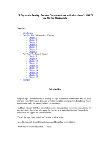
Chapter 13Aviation Weather ServicesIntroductionIn aviation, weather service is a combined effort of theNational Weather Service (NWS), Federal AviationAdministration (FAA), Department of Defense (DOD), otheraviation groups, and individuals. Because of the increasingneed for worldwide weather services, foreign weatherorganizations also provide vital input.While weather forecasts are not 100 percent accurate,meteorologists, through careful scientific study and computermodeling, have the ability to predict weather patterns, trends,and characteristics with increasing accuracy. Through acomplex system of weather services, government agencies,and independent weather observers, pilots and other aviationprofessionals receive the benefit of this vast knowledge basein the form of up-to-date weather reports and forecasts.These reports and forecasts enable pilots to make informeddecisions regarding weather and flight safety before andduring a flight.13-11133-11
ObservationsThe data gathered from surface and upper altitudeobservations form the basis of all weather forecasts,advisories, and briefings. There are four types of weatherobservations: surface, upper air, radar, and satellite.Surface Aviation Weather ObservationsSurface aviation weather observations (METARs) are acompilation of elements of the current weather at individualground stations across the United States. The network ismade up of government and privately contracted facilitiesthat provide continuous up-to-date weather information.Automated weather sources, such as the Automated WeatherObserving Systems (AWOS), Automated Surface ObservingSystems (ASOS), as well as other automated facilities, alsoplay a major role in the gathering of surface observations.Surface observations provide local weather conditionsand other relevant information for a specific airport. Thisinformation includes the type of report, station identifier,date and time, modifier (as required), wind, visibility,runway visual range (RVR), weather phenomena, skycondition, temperature/dew point, altimeter reading, andapplicable remarks. The information gathered for the surfaceobservation may be from a person, an automated station, oran automated station that is updated or enhanced by a weatherobserver. In any form, the surface observation providesvaluable information about individual airports around thecountry. Although the reports cover only a small radius, thepilot can generate a good picture of the weather over a widearea when many reporting stations are viewed together.Air Route Traffic Control Center (ARTCC)The Air Route Traffic Control Center (ARTCC) facilitiesare responsible for maintaining separation between flightsconducted under instrument flight rules (IFR) in the enroute structure. Center radars (Air Route Surveillance Radar(ARSR)) acquire and track transponder returns using the samebasic technology as terminal radars. Earlier center radarsdisplayed weather as an area of slashes (light precipitation)and Hs (moderate rainfall). Because the controller could notdetect higher levels of precipitation, pilots had to be waryof areas showing moderate rainfall. Newer radar displaysshow weather as three shades of blue. Controllers can selectthe level of weather to be displayed. Weather displays ofhigher levels of intensity make it difficult for controllers tosee aircraft data blocks, so pilots should not expect air trafficcontrol (ATC) to keep weather displayed continuously.Upper Air ObservationsObservations of upper air weather are more challengingthan surface observations. There are several methods bywhich upper air weather phenomena can be observed:13-2radiosonde observations, pilot weather reports (PIREPs),Aircraft Meteorological Data Relay (AMDAR) and theMeteorological Data Collection and Reporting System(MDCRS). A radiosonde is a small cubic instrumentationpackage that is suspended below a six foot hydrogen- orhelium-filled balloon. Once released, the balloon rises at a rateof approximately 1,000 feet per minute (fpm). As it ascends,the instrumentation gathers various pieces of data, such as airtemperature, moisture, and pressure, as well as wind speedand direction. Once the information is gathered, it is relayedto ground stations via a 300 milliwatt radio transmitter.The balloon flight can last as long as 2 hours or more andcan ascend to altitudes as high as 115,000 feet and drift asfar as 125 miles. The temperatures and pressures experiencedduring the flight can be as low as -130 F and pressures aslow as a few thousandths of what is experienced at sea level.Since the pressure decreases as the balloon rises in theatmosphere, the balloon expands until it reaches the limitsof its elasticity. This point is reached when the diameter hasincreased to over 20 feet. At this point, the balloon pops andthe radiosonde falls back to Earth. The descent is slowed bymeans of a parachute. The parachute aids in protecting peopleand objects on the ground. Each year over 75,000 balloonsare launched. Of that number, 20 percent are recovered andreturned for reconditioning. Return instructions are printedon the side of each radiosonde.Pilots also provide vital information regarding upper airweather observations and remain the only real-time sourceof information regarding turbulence, icing, and cloudheights. This information is gathered and filed by pilotsin flight. Together, PIREPs and radiosonde observationsprovide information on upper air conditions important forflight planning. Many domestic and international airlineshave equipped their aircraft with instrumentation thatautomatically transmits in flight weather observationsthrough the DataLink system.The Aircraft Meteorological Data Relay (AMDAR) isan international program utilizing commercial aircraft toprovide automated weather observations. The AMDARprogram provides approximately 220,000-230,000 aircraftobservations per day on a worldwide basis utilizing aircraftonboard sensors and probes that measure wind, temperature,humidity/water vapor, turbulence and icing data. AMDARvertical profiles and en route observations provide significantbenefits to the aviation community by enhancing aircraftsafety and operating efficiency through improved weatheranalysis and forecasting. The AMDAR program alsocontributes to improved short and medium term numericalweather forecasts for a wide range of services including
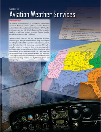
severe weather, defense, marine, public weather andenvironmental monitoring. The information is down linkedeither via Very High Frequency (VHF) communicationsthrough the Aircraft Communications Addressing andReporting System (ACARS) or via satellite link through theAircraft to Satellite Data Acquisition and Relay (ASDAR).The Meteorological Data Collection and Reporting System(MDCRS) is an automated airborne weather observationprogram that is used in the U.S. This program collects anddisseminates real-time upper-air weather observations fromparticipating airlines. The weather elements are down linkedvia ACARS and are managed by Aeronautical Radio, Inc.(ARINC) who then forwards them in Binary Universal Formfor the Representation of Meteorological Data (BUFR)format to the NWS and in raw data form to the Earth ScienceResearch Laboratory (ESRL) and the participating airline.More than 1,500 aircraft report wind and temperature datawith some of these same aircraft also providing turbulenceand humidity/water vapor information. In conjunction withavionics manufacturers, each participating airline programstheir equipment to provide certain levels of meteorologicaldata. The monitoring and collection of climb, en route, anddescent data is accomplished through the aircraft’s Flight DataAcquisition and Monitoring System (FDAMS) and is thentransmitted via ACARS. When aircraft are out of ACARSrange, reports can be relayed through ASDAR. However, inmost cases, the reports are buffered until the aircraft comeswithin ACARS range, at which point they are downloaded.Figure 13-1. Example of a weather radar scope.Radar ObservationsThere are four types of radars which provide informationabout precipitation and wind.1.The WSR-88D NEXRAD radar, commonly calledDoppler radar, provides in-depth observations thatinform surrounding communities of impendingweather. Doppler radar has two operational modes:clear air and precipitation. In clear air mode, the radaris in its most sensitive operational mode because aslow antenna rotation allows the radar to sample theatmosphere longer. Images are updated about every10 minutes in this mode.Precipitation targets provide stronger return signals;therefore, the radar is operated in the Precipitationmode when precipitation is present. A faster antennarotation in this mode allows images to update ata faster rate, approximately every 4 to 6 minutes.Intensity values in both modes are measured indBZ (decibels of Z) and are depicted in color on theradar image. [Figure 13-1] Intensities are correlatedto intensity terminology (phraseology) for ATCpurposes. [Figures 13-2 and 13-3]Figure 13-2. WSR-88D Weather Radar Echo Intensity Legend.Reflectivity (dBZ) RangesWeather Radar Echo Intensity 30 dBZ30–40 dBZ 40–5050 dBZLightModerateHeavyExtremeFigure 13-3. WSR-88D Weather Radar Precipitation IntensityTerminology.13-3
2.FAA terminal Doppler weather radar (TDWR),installed at some major airports around the country,also aids in providing severe weather alerts andwarnings to ATC. Terminal radar ensures pilotsare aware of wind shear, gust fronts, and heavyprecipitation, all of which are dangerous to arrivingand departing aircraft.3.The third type of radar commonly used in the detectionof precipitation is the FAA airport surveillance radar.This radar is used primarily to detect aircraft, but italso detects the location and intensity of precipitation,which is used to route aircraft traffic around severeweather in an airport environment.4.Airborne radar is equipment carried by aircraft tolocate weather disturbances. The airborne radarsgenerally operate in the C or X bands (around 6GHz or around 10 GHz, respectively) permittingboth penetration of heavy precipitation, required fordetermining the extent of thunderstorms, and sufficientreflection from less intense precipitation.SatelliteAdvancement in satellite technologies has recently allowedfor commercial use to include weather uplinks. Through theuse of satellite subscription services, individuals are now ableto receive satellite transmitted signals that provide near realtime weather information for the North American continent.Service OutletsService outlets are government, government contract, orprivate facilities that provide aviation weather services. Severaldifferent government agencies, including the FAA, NationalOceanic and Atmospheric Administration (NOAA), and theNWS work in conjunction with private aviation companiesto provide different means of accessing weather information.recordings of meteorological and aeronautical information.TIBS provides area and route briefings, airspace procedures,and special announcements. The recordings are automaticallyupdated as changes occur. It is designed to be a preliminarybriefing tool and is not intended to replace a standard briefingfrom a FSS specialist. The TIBS service can only be accessedby a touchtone phone. The phone numbers for the TIBSservice are listed in the Chart Supplement U.S. (formerlyAirport/Facility Directory).Hazardous Inflight Weather Advisory Service(HIWAS)Hazardous Inflight Weather Advisory Service (HIWAS),available in the 48 conterminous states, is an automatedcontinuous broadcast of hazardous weather informationover selected VOR navigational aids (NAVAIDs). Thebroadcasts include advisories such as AIRMETS, SIGMETS,convective SIGMETS, and urgent PIREPs. The broadcastsare automatically updated as changes occur. Pilots shouldcontact a FSS or EFAS for additional information. VORs thathave HIWAS capability are depicted on aeronautical chartswith an “H” in the upper right corner of the identificationbox. [Figure 13-4]Transcribed Weather Broadcast (TWEB) (AlaskaOnly)A continuous automated broadcast of meteorological andaeronautical data over selected low or medium frequency (L/MF) and very high frequency (VHF) omnidirectional range(VOR) NAVAID facilities. The broadcasts are automaticallyupdated as changes occur. The broadcast contains adverseconditions, surface weather observations, PIREPS, anda density altitude statement (if applicable). Recordingsmay also include a synopsis, winds aloft forecast, en routeand terminal forecast data, and radar reports. At selectedlocations, telephone access to the TWEB has been provided(TEL-TWEB). Telephone numbers for this service are foundFlight Service Station (FSS)The FSS is the primary source for preflight weatherinformation. A preflight weather briefing from an FSS can beobtained 24 hours a day by calling 1-800-WX BRIEF fromanywhere in the United States and Puerto Rico. Telephonenumbers for FSS can be found in the Chart Supplement U.S.(formerly Airport/Facility Directory) or in the United StatesGovernment section of the telephone book.The FSS also provides inflight weather briefing servicesand weather advisories to flights within the FSS area ofresponsibility.Telephone Information Briefing Service (TIBS)The Telephone Information Briefing Service (TIBS),provided by FSS, is a system of automated telephone13-4Symbol indicates HIWASFigure 13-4. HIWAS availability is shown on sectional chart.
in the Alaska Chart Supplement U.S. (formerly Airport/Facility Directory). These broadcasts are made availableprimarily for preflight and inflight planning, and as such,should not be considered as a substitute for specialistprovided preflight briefings.5.En route forecast—a summary of the weather forecastfor the proposed route of flight.6.Destination forecast—a summary of the expectedweather for the destination airport at the estimatedtime of arrival (ETA).Weather Briefings7.Forecast winds and temperatures aloft—a forecast ofthe winds at specific altitudes for the route of flight.The forecast temperature information aloft is providedonly upon request.8.Notices to Airmen (NOTAM)—information pertinentto the route of flight that has not been published in theNOTAM publication. Published NOTAM informationis provided during the briefing only when requested.9.ATC delays—an advisory of any known ATC delaysthat may affect the flight.Prior to every flight, pilots should gather all informationvital to the nature of the flight. This includes an appropriateweather briefing obtained from a specialist at a FSS.For weather specialists to provide an appropriate weatherbriefing, they need to know which of the three types ofbriefings is needed—standard, abbreviated, or outlook. Otherhelpful information is whether the flight is visual flight rules(VFR) or IFR, aircraft identification and type, departurepoint, estimated time of departure (ETD), flight altitude, routeof flight, destination, and estimated time en route (ETE).This information is recorded in the flight plan system and anote is made regarding the type of weather briefing provided.If necessary, it can be referenced later to file or amend aflight plan. It is also used when an aircraft is overdue or isreported missing.Standard BriefingA standard briefing provides the most complete informationand a more complete weather picture. This type of briefingshould be obtained prior to the departure of any flight andshould be used during flight planning. A standard briefingprovides the following information in sequential order if itis applicable to the route of flight.1.Adverse conditions—this includes information aboutadverse conditions that may influence a decision tocancel or alter the route of flight. Adverse conditionsinclude significant weather, such as thunderstorms oraircraft icing, or other important items such as airportclosings.2.VFR flight not recommended—if the weather forthe route of flight is below VFR minimums, or ifit is doubtful the flight could be made under VFRconditions due to the forecast weather, the briefer maystate “VFR flight not recommended.” It is the pilot’sdecision whether or not to continue the flight underVFR, but this advisory should be weighed carefully.3.Synopsis—an overview of the larger weather picture.Fronts and major weather systems that affect thegeneral area are provided.4.Current conditions—the current ceilings, visibility,winds, and temperatures. If the departure time is morethan 2 hours away, current conditions are not includedin the briefing.10. Other information—at the end of the standard briefing,the FSS specialist provides the radio frequenciesneeded to open a flight plan and to contact EFAS. Anyadditional information requested is also provided atthis time.Abbreviated BriefingAn abbreviated briefing is a shortened version of the standardbriefing. It should be requested when a departure has beendelayed or when weather information is needed to updatethe previous briefing. When this is the case, the weatherspecialist needs to know the time and source of the previousbriefing so the necessary weather information is not omittedinadvertently. It is always a good idea for the pilot to updatethe weather information whenever he/she has additional time.Outlook BriefingAn outlook briefing should be requested when a planneddeparture is 6 hours or more away. It provides initial forecastinformation that is limited in scope due to the time frameof the planned flight. This type of briefing is a good sourceof flight planning information that can influence decisionsregarding route of flight, altitude, and ultimately the go/no-godecision. A prudent pilot requests a follow-up briefing priorto departure since an outlook briefing generally only containsinformation based on weather trends and existing weather ingeographical areas at or near the departure airport. A standardbriefing near the time of departure ensures that the pilot hasthe latest information available prior to his/her flight.Aviation Weather ReportsAviation weather reports are designed to give accuratedepictions of current weather conditions. Each reportprovides current information that is updated at different times.Some typical reports are METARs and PIREPs.13-5
Aviation Routine Weather Report (METAR)A METAR is an observation of current surface weatherreported in a standard international format. While theMETAR code has been adopted worldwide, each country isallowed to make modifications to the code. Normally, thesedifferences are minor but necessary to accommodate localprocedures or particular units of measure. This discussion ofMETAR covers elements used in the United States.METARs are issued on a regularly scheduled basis unlesssignificant weather changes have occurred. A specialMETAR (SPECI) can be issued at any time between routineMETAR reports.4.When the modifier “COR” is used, it identifies acorrected report sent out to replace an earlier reportthat contained an error (for example: METAR KGGG161753Z COR).5.Wind—reported with five digits (14021KT) unlessthe speed is greater than 99 knots, in which case thewind is reported with six digits. The first three digitsindicate the direction the true wind is blowing from intens of degrees. If the wind is variable, it is reportedas “VRB.” The last two digits indicate the speed ofthe wind in knots unless the wind is greater than 99knots, in which case it is indicated by three digits. Ifthe winds are gusting, the letter “G” follows the windspeed (G26KT). After the letter “G,” the peak gustrecorded is provided. If the wind direction varies morethan 60 and the wind speed is greater than six knots,a separate group of numbers, separated by a “V,” willindicate the extremes of the wind directions.6.Visibility—the prevailing visibility (¾ SM) is reportedin statute miles as denoted by the letters “SM.” It isreported in both miles and fractions of miles. At times,runway visual range (RVR) is reported following theprevailing visibility. RVR is the distance a pilot cansee down the runway in a moving aircraft. When RVRis reported, it is shown with an R, then the runwaynumber followed by a slant, then the visual rangein feet. For example, when the RVR is reported asR17L/1400FT, it translates to a visual range of 1,400feet on runway 17 left.7.Weather—can be broken down into two differentcategories: qualifiers and weather phenomenon( TSRA BR). First, the qualifiers of intensity,proximity, and the descriptor of the weather are given.The intensity may be light (–), moderate ( ), or heavy( ). Proximity only depicts weather phenomena thatare in the airport vicinity. The notation “VC” indicatesa specific weather phenomenon is in the vicinityof five to ten miles from the airport. Descriptorsare used to describe certain types of precipitationand obscurations. Weather phenomena may bereported as being precipitation, obscurations, andother phenomena, such as squalls or funnel clouds.Example:METAR KGGG 161753Z AUTO 14021G26KT 3/4SM TSRA BR BKN008 OVC012CB 18/17 A2970 RMKPRESFRA typical METAR report contains the following informationin sequential order:1.2.3.13-6Type of report—there are two types of METARreports. The first is the routine METAR report that istransmitted on a regular time interval. The second isthe aviation selected SPECI. This is a special reportthat can be given at any time to update the METAR forrapidly changing weather conditions, aircraft mishaps,or other critical information.Station identifier—a four-letter code as established bythe International Civil Aviation Organization (ICAO).In the 48 contiguous states, a unique three-letteridentifier is preceded by the letter “K.” For example,Gregg County Airport in Longview, Texas, isidentified by the letters “KGGG,” K being the countrydesignation and GGG being the airport identifier.In other regions of the world, including Alaska andHawaii, the first two letters of the four-letter ICAOidentifier indicate the region, country, or state. Alaskaidentifiers always begin with the letters “PA” andHawaii identifiers always begin with the letters “PH.”Station identifiers can be found by calling the FSS, aNWS office, or by searching various websites suchas DUATS and NOAA's Aviation Weather AviationDigital Data Services (ADDS).Date and time of report—depicted in a six-digit group(161753Z). The first two digits are the date. The lastfour digits are the time of the METAR/SPECI, whichis always given in coordinated universal time (UTC).A “Z” is appended to the end of the time to denotethe time is given in Zulu time (UTC) as opposed tolocal time.Modifier—denotes that the METAR/SPECI came froman automated source or that the report was corrected. Ifthe notation “AUTO” is listed in the METAR/SPECI,the report came from an automated source. It also lists“AO1” (for no precipitation discriminator) or “AO2”(with precipitation discriminator) in the “Remarks”section to indicate the type of precipitation sensorsemployed at the automated station.
Descriptions of weather phenomena as they begin orend and hailstone size are also listed in the “Remarks”sections of the report. [Figure 13-5]8.9.Sky condition—always reported in the sequence ofamount, height, and type or indefinite ceiling/height(vertical visibility) (BKN008 OVC012CB, VV003).The heights of the cloud bases are reported with athree-digit number in hundreds of feet AGL. Cloudsabove 12,000 feet are not detected or reported by anautomated station. The types of clouds, specificallytowering cumulus (TCU) or cumulonimbus (CB)clouds, are reported with their height. Contractionsare used to describe the amount of cloud coverage andobscuring phenomena. The amount of sky coverage isreported in eighths of the sky from horizon to horizon.[Figure 13-6]Temperature and dew point—the air temperature anddew point are always given in degrees Celsius (C) or(18/17). Temperatures below 0 C are preceded bythe letter “M” to indicate minus.10. Altimeter setting—reported as inches of mercury("Hg) in a four-digit number group (A2970). It isalways preceded by the letter “A.” Rising or fallingpressure may also be denoted in the “Remarks”sections as “PRESRR” or “PRESFR,” respectively.11. Zulu time—a term used in aviation for UTC, whichplaces the entire world on one time standard.Sky CoverContractionLess than 8 (Clear) 8– 8 (Few)x 8– 8 (Scattered) 5 8–7 8 (Broken)8 8 or (Overcast)SKC, CLR, FEWFEWSCTBKNOVCFigure 13-6. Reportable contractions for sky condition.12. Remarks—the remarks section always begins with theletters “RMK.” Comments may or may not appear inthis section of the METAR. The information containedin this section may include wind data, variablevisibility, beginning and ending times of particularphenomenon, pressure information, and various otherinformation deemed necessary. An example of aremark regarding weather phenomenon that does notfit in any other category would be: OCNL LTGICCG.This translates as occasional lightning in the cloudsand from cloud to ground. Automated stations also usethe remarks section to indicate the equipment needsmaintenance.Example:METAR KGGG 161753Z AUTO 14021G26KT 3/4SM TSRA BR BKN008 OVC012CB 18/17 A2970 RMKPRESFRQualifierIntensity or Proximity 1Weather PhenomenaDescriptor 2Precipitation 3Obscuration 4Other 5MI ShallowDZ DrizzleBR MistPO Dust/sand whirlsBC PatchesRA RainFG FogSQ Squalls HeavyDR Low driftingSN SnowFU SmokeFC Funnel cloudVC in the vicinityBL BlowingSG Snow grainsDU Dust FC Tornado or waterspoutSH ShowersIC Ice crystals (diamond dust)SA SandSS SandstormTS ThunderstormsPL Ice pelletsHZ HazeDS Dust stormFZ FreezingGR HailPY SprayPR PartialGS Small hail or snow pelletsVA Volcanic ash– LightModerate (no qualifier)UP *Unknown precipitationThe weather groups are constructed by considering columns 1–5 in this table in sequence:intensity, followed by descriptor, followed by weather phenomena (e.g., heavy rain showers(s) is coded as SHRA).* Automated stations onlyFigure 13-5. Descriptors and weather phenomena used in a typical METAR.13-7
Explanation:Routine METAR for Gregg County Airport for the 16thday of the month at 1753Z automated source. Winds are140 at 21 knots gusting to 26. Visibility is ¾ statute mile.Thunderstorms with heavy rain and mist. Ceiling is brokenat 800 feet, overcast at 1,200 feet with cumulonimbus clouds.Temperature 18 C and dew point 17 C. Barometric pressureis 29.70 "Hg and falling rapidly.Pilot Weather Reports (PIREPs)PIREPs provide valuable information regarding theconditions as they actually exist in the air, which cannot begathered from any other source. Pilots can confirm the heightof bases and tops of clouds, locations of wind shear andturbulence, and the location of inflight icing. If the ceiling isbelow 5,000 feet, or visibility is at or below five miles, ATCfacilities are required to solicit PIREPs from pilots in the area.When unexpected weather conditions are encountered, pilotsare encouraged to make a report to a FSS or ATC. When apilot weather report is filed, the ATC facility or FSS adds itto the distribution system to brief other pilots and provideinflight advisories.PIREPs are easy to file and a standard reporting form outlinesthe manner in which they should be filed. Figure 13-7 showsthe elements of a PIREP form. Item numbers 1 through 5 arerequired information when making a report, as well as at leastone weather phenomenon encountered. A PIREP is normallytransmitted as an individual report but may be appended toa surface report. Pilot reports are easily decoded, and mostcontractions used in the reports are self-explanatory.Example:UA/OV GGG 090025/TM 1450/FL 060/TP C182/SK080 OVC/WX FV04SM RA/TA 05/WV 270030KT/TBLGT/RM HVY RAINExplanation:Type: .Routine pilot reportLocation: . 25 NM out on the 090 radial,Gregg County VORTime: . 1450 ZuluAltitude or Flight Level: 6,000 feetAircraft Type: . Cessna 182Sky Cover: .8,000 overcastVisibility/Weather: . 4 miles in rainTemperature: .5 CelsiusWind: . 270 at 30 knotsTurbulence: .LightIcing: . None reportedRemarks: . Rain is heavyEncoding Pilot Weather Reports (PIREPS)123XXXUA/OV3-letter station identifierRoutine PIREP, UUA-Urgent PIREP.Location4567/TM/FL/TP/SKTimeAltitude/flight levelType aircraftSky cover/cloud layers8/WXWeather910/TA/WVAir temperature in celsius (C)Wind11/TBTurbulence12/ICIcing13/RMRemarksFigure 13-7. PIREP encoding and decoding.13-8Nearest weather reporting location to the reported phenomenonUse 3-letter NAVAID idents only.a. Fix: /OV ABC, /OV ABC 090025.b. Fix: /OV ABC 045020-DEF, /OV ABC-DEF-GHI4 digits in UTC: /TM 0915.3 digits for hundreds of feet. If not known, use UNKN: /FL095, /FL310, /FLUNKN.4 digits maximum. If not known, use UNKN: /TP L329, /TP B727, /TP UNKN.Describe as follows:a. Height of cloud base in hundreds of feet. If unknown, use UNKN.b. Cloud cover symbol.c. Height of cloud tops in hundreds of feet.Flight visibility reported first:Use standard weather symbols:/WX FV02SM RA HZ, /WX FV01SM TSRA.If below zero, prefix with a hyphen: /TA 15, /TA M06.Direction in degrees magnetic north and speed in six digits:/WV270045KT, WV 280110KT.Use standard contractions for intensity and type (use CAT or CHOP whenappropriate). Include altitude only if different from /FL, /TB EXTRM, /TBLGT-MOD BLO 090.Describe using standard intensity and type contractions. Include altitude only ifdifferent than /FL: /IC LGT-MOD RIME, /IC SEV CLR 028-045.Use free form to clarify the report and type hazardous elements first:/RM LLWS -15KT SFC-030 DURC RY22 JFK.
Aviation ForecastsObserved weather condition reports are often used in thecreation of forecasts for the same area. A variety of differentforecast products are produced and designed to be used in thepreflight planning stage. The printed fore
Chapter 13. 13-2 Observations The data gathered from surface and upper altitude observations form the basis of all weather forecasts, advisories, and briefings. There are four types of weather observations: surface, upper air, radar, and satellite. Surface Aviation Weather Observations