Transcription
Plantation AnalysisThis chapter provides a discussion of existing antebellumplantations in Prince George’s County by integrating thearchitectural, archeological, and historical research relevant to anunderstanding of the agriculture and slavery in the county. Subsections areorganized temporally; the temporal divisions correlate with those outlined in“Agriculture and Slavery: A Context for Prince George’s County, Maryland.”Each subsection addresses important aspects of plantation organizationand includes a discussion of architecture, slave quarters, and slave burials.“Architecture” refers to the type and function of agricultural structuresnecessary for the operation of plantations of various slaveholding sizesas defined in “Agriculture and Slavery.” Although they are an importantcomponent of plantation architecture, “slave quarters” are discussedseparately because of the cultural (in addition to functional) complexitiesassociated with their use. This discussion examines the known types anddistribution of slave housing across time on the variously sized plantations.The “slave burial” subsection discusses the nature and distribution of slaveburials across temporal periods and between plantations of different sizes.Each section concludes with a “Summary” pertaining to each time periodand plantation size.Early Period—1696–1730The period extending from 1696 to 1730 is the least documented of thethree temporal divisions investigated. For this period, the analysis of theorganization and operation of plantations is based on the few examples ofperiod plantations that remain on the landscape today. Most structures fromthe Early Period, including the plantation house, utilized post-in-groundarchitecture and did not survive into the twentieth century. Archeologicalevidence derives primarily from limited investigations conducted on andimmediately around the manor houses and includes information on spatiallayouts and the material culture associated with these early historicalsites. In addition to the archeological record, primary records, such asprobate inventories, can be used to infer plantation activities through theirdescriptions of tools and chattel, including slaves, for which they account.Although these records do not specifically detail spatial relationships, theynonetheless provide valuable information regarding plantation operationsand the types of ancillary structures necessary to support or house theinventoried goods.
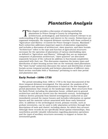
Plantation ArchitectureA total of 12 known Prince George’s County plantations were constructedduring the Early Period (Figure 20, also Table 8): Fair Running (PG:71B-15, a.k.a., Issac’s Discovery) Northampton (PG:73-12) Dunblane (PG:78-10) Melwood Park* (PG:78-15) Oxon Hill Manor (PG:80-1) Battersea/Harmony Hall (PG:80-11) Want Water (PG:80-24) Bellefields* (PG:82A-26, a.k.a., Simm’s Delight) Darnall’s Delight (PG:82A-41, a.k.a. the Woodyard) Billingsley* (PG:82B-3) Anchovie Hills (PG:87A-17) Elizabeth’s Delight (M:37-5)* Denotes all or portion of original, Early Period structure remains standingA gas explosion in 1969 destroyed Dunblane. The original 1710 OxonHill Manor house burned in 1895; the current Oxon Hill manor house wasconstructed in 1929. The house at Darnall’s Delight, which dates to the latenineteenth century, was found to be in dilapidated condition as of 1982;currently Darnall’s Delight exists only as an archeological site. The plantationhouse at Elizabeth’s Delight is located within Montgomery County although thelandholdings extend into Prince George’s County.The remains of the late-seventeenth and early-eighteenth centuries WantWater and Northampton plantation houses exist only as archeological sites.The remains of two suspected slave quarters located on the Northampton sitedate to the early or middle part of the nineteenth century (see section “SlaveQuarters”). Fair Running has been extensively altered. Finally, althoughpopularly believed to date to 1723, the house at Harmony Hall likely datesto the middle or late eighteenth century based on recent historic research(Sonderman et al. 1993:11-13). Nonetheless, archeological excavation identifiedearly-eighteenth-century and possible late-seventeenth-century depositssuggestive of plantation operations during the Early Period.72Antebellum Plantations in Prince George’s County, Maryland
Source: Ottery Group from MIHP FormsFigure 20: Location of Early Period Plantations in Prince George’s CountyAntebellum Plantations in Prince George’s County, Maryland73
74Antebellum Plantations in Prince George’s County, MarylandPlantationNameGallant HouseOaklandsSnow HillMontpelierWalnut GrangeSnowden/Snowden HallGreen Hill/Chillum CastleManorWhite HouseTavern/Brown’sTavernMIHP 2–013PG:64–001PG:65–008PG:66–001John Brown (1834–postbellum)William Dudley Digges(?–1831), Nora Digges (1831–1863)Rezin H. Snowden (1829–1857), John Snowden (1857–1872)John Carlyle Herbert (1805–1846), Mary Snowden Herbert(1846–1857), Richard DuckettHall (1859–1863)Thomas Snowden (1750–1770),Major Snowden (1770–1803),Nicholas Snowden (1803–1835), Maria Snowden andTheodore Jenkins (1835–1866)Samuel Snowden, Jr(1800–1823), Sarah Snowden(1823–1865)Richard Snowden (1798–1823),Ann Louisa Snowden and Lt.John Contee (1823–1840),children of Ann LouisaSnowden and John Contee(1840–1878)Owen Carroll (circa alConstructionPeriodNoneNoneIce house, smokehouse, carriagehouse, slavequarters (unsureif still standing––provided byinformant)None18th centurysummerhouse, 18thcentury gazebo,20th centuryoutbuildingLog smokehousecirca 18005 outbuildings (allpostbellum)NoneOutbuildingsTable 8: Known Prince George’s County Plantations10260 BaltimoreAvenue, College Park2009 Van BurenStreet, WestHyattsvillePatuxent ResearchCenter, Bldg. 016,Laurel Bowie Road,LaurelMIHP FormMIHP FormMIHP FormMIHP FormMIHP Form9650 Muirkirk Road,Laurel6300 Powder MillRoad, BeltsvilleMIHP FormMIHP Form; AAHA2003, 2004a, and2004bMIHP FormReference13209 Laurel-BowieRoad, Laurel8314 Contee Road,Laurel3124 Powder MillRoad, AdelphiAddress/Location
Antebellum Plantations in Prince George’s County, Maryland75PlantationNameDeakins HallSportland/YarrowAsh Hill/Hitching PostHillRiversdaleMount HopeW.T. DuvallHouse (BuenaVista)MariettaMarcus DuvallHouse andCemetery/Wigwam FarmProspect HillMIHP 5George W. Duvall (1820–postbellum)Marcus Duvall (b.1824–postbellum)Gabriel Duvall (1812–1844),Marcus Duvall (1844–postbellum)William T. Duvall (1856–postbellum)Fielder Magruder, Jr. (1839–postbellum)Henri Joseph Stier (1801–1803), George Calvert anddescendants ediumSmallMedium toLargeLargeLargeLargeColonialJames Edmonston (1768–1793), Ruth Edmonston/Nathan Edmonston (1793–1820), Benjamin and RichardWelch and heirs (1820–1850s),Ethan Allen Jones (1850–postbellum)Robert Clark ionPeriodLeonard Deakins (1746–1824.),William Francis Deakins (1824– postbellum)OwnershipBarn, ice house,tenant house,smokehouse,overseers houseNone2 early 19th centuryoutbuildingsNo outbuildingsPossible circa1800structure. Spring(PG:69–13)Brick dependencyNoneNoneAdjacent cemeteryOutbuildingsTable 8: Known Prince George’s County Plantations (cont’d)11501 Old ProspectHill Road, Glenn DaleSouth of 11900Glenn DaleBoulevard, GlennDale5626 Bell StationRoad, Glenn Dale4811 Glenn DaleRoad, Mitchellville1 Cheverly Circle,Cheverly4811 Riverdale Road,Riverdale Park3308 Rosemary Lane,Hyattsville5933 Natasha Road,Berwyn Heights6404 Queen’s ChapelRoad, UniversityParkAddress/LocationMIHP FormMIHP FormMIHP Form,letters describingoutbuildings andslave quartersMIHP FormMIHP FormMIHP Form,Callcott 1991,Riversdale Park1997, archeologyreportsMIHP FormMIHP FormMIHP FormReference
76Antebellum Plantations in Prince George’s County, MarylandWilliamsPlainsBelairFair PG:71B–015FairviewPG:71A–013Bowie –Arnold House(Darnall’sGrove earlier)Willow GrovePG:71A–011PG:71A–014PlantationNameMIHP IDJoseph Peach (1727–1764),John Peach (1764–circa1766), Joseph Peach, II (circa1766–1775), Joseph Peach,III (1775–1814), Barton Duvall(1814–?), Philip and Mary AnnDuvall (?–1850), Richard andTruman Cross for ElizabethPage (1850–postbellum)Samuel Ogle (1737–1752),Benjamin Tasker Sr. & Jr.(1753–1770), Benjamin Ogle(1770–1809), Benjamin Ogle II(1809–1844), George C. Ogle(1844–1871)John Johnson (1770–1824),Basil Duckett Mullikin (1829–postbellum)Anne M. Bowie (widow ofWilliam Bowie) remarriedCharles Worthington (1832–post–bellum)Baruch Duckett (1800–1810),William Bowie (1810–1826),William Duckett Bowie (1826–postbellum)John Bowie, Sr. (1705–1759),Capt. William Bowie (1759–1791), Walter Bowie, Sr.(1791–1810), Walter Bowie Jr.(1810–1839), Richard W.W.Bowie tionPeriod5 outbuildings(1798): kitchen,negro house,meathouse, cornhouse, stable2 story brickbuilding used asoffice/kitchen(circa 1748), barn,cider mill, and milkhouse (all circa1757)NoneBank Barn,IcehouseBarn, milkhouse(circa 1800), Slavequarters, cemeteryBowie cemetery(moved), includingbrick–lined crypts,tobacco barnOutbuildingsTable 8: Known Prince George’s County Plantations (cont’d)7704 Laurel BowieRoad, Bowie12207 Tulip GroveDrive, Bowie16200 WhitemarshPark Drive, BowieMIHP FormMIHP FormMIHP FormMIHP Form, 1798Direct TaxMIHP Form, EACA2004FairwoodSubdivision, 4410Church Road,Mitchellville4311 Church Road,BowieMIHP Form; Gill2006; RCG&A 1997ReferenceMD 450 (oppositeHoly Trinity Church),BowieAddress/Location
Antebellum Plantations in Prince George’s County, Maryland77Beall’sPleasureWaring’s GroveVan Horn–Mitchell HouseThree SistersBelvidereWarington –BarnThe Cottage ��002PG:73–005PG:73–006PG:73-007Rose IHP IDJoseph Kent Roberts (1840 –1883)Washington Hilleary (1842–1860), Mary Virginia Mackubin(1860–postbellum)Marsham Waring (? – 1860)Belt Brashears (17?–1815),George W. Duvall [ProspectHill] (1815–?), George W.Duvall II (1856–postbellum)Hilleary Family [ Turnerand Williams] (1683 –18?),Ninian Willett (18?–1826),heirs of Ninian (1826–1835),John Beale Magruder (1835–postbellum)Archibald Van Horn (1803–1817), Walter T.G. Beall(1817–1842), James Fowler(1842–1893)Thomas Waring (1756–1796),Zachariah Berry (1796–1820),Zachariah Berry II (1820–1859), Zachariah Berry III(1859–1870)Thomas Ewell (1813–circa1814), John and WilliamThomas (circa1814–1835), LeviSherriff (1835–1856), GeorgeBeall Sherriff, Lemuel LeviSherriff, Jr., and Dionysius T.Sherriff (1856–1866)Allen Bowie Duckett andRichard Duckett (most of sNationalConstructionPeriodTenant house,barns, cemeteryNoneTobacco barnNoneNoneIce house andsmoke house (nolonger standing),several 20th centuryoutbuildingsSeveral 20thcenturyoutbuildingsBarn, meathouse,office (19thcentury), slavequarters (circa1850, unconfirmed)OutbuildingsTable 8: Known Prince George’s County Plantations (cont’d)9600 Landover Road,Landover3102 Lottsford VistaRoad, Mitchellville2708 EnterpriseRoad, Mitchellville11401 BelvidereRoad, Mitchellville10408 Cleary Lane,Mitchellville4706 Mann Street,Fairmount HeightsMIHP FormMIHP FormMIHP FormMIHP FormMIHP FormMIHP FormMIHP Form; Gibb2004; JMA 2004MIHP Form7460 Landover Road,Landover900 Brightseat Road,LandoverMIHP Form;Hoffman, et al.2007; The OtteryGroup 2005Reference17107 MelfordBoulevard, BowieAddress/Location
78Antebellum Plantations in Prince George’s County, antationNameMIHP IDMary Mackall Bowie WoottonBowie (1818–1825), WilliamJ. Berry (1825–1840s),descendants of William J.Berry through 20th centuryBenjamin Hall (late 18thcentury–1803), Henry LoweHall (1803–1817), BenjaminHall Clark (1817–1844),Thomas E. Berry (1844–1878)James Mullikin anddescendants from late 17thcentury through 1880sCharles Clement HillIsaac Duckett (1788–1823),Lt. John Contee (1823–1839),Captain John Contee (1839–1863)Humphery Belt (1761–1798),Zacharia Berry (1798–1866)[absentee, tenant]Dennis Magruder (1779–1832), Dennis Magruder Jr.(1832–1835), Dewit Kent(1835–1839), Otho Berry Beall(1839–1840), WashingtonJ. Beall (1840–mid 1850s),William John Bowie (mid–1850s–1886)Sprigg family (early eMedium Early/Colonial/NationalConstructionPeriodTobacco barn, farmoutbuildings (firsthalf of 19th century)Smokehouse,corncrib, brickstable (datesunconfirmed)Corncrib (pre–1895), stable (19thcentury), dairy(18th century)2 slave quarters(National Period)OutbuildingsTable 8: Known Prince George’s County Plantations (cont’d)522 Church Road,Upper Marlboro13710 CentralAvenue, Largo2307 Church Road,Mitchellville2202 BermondseyDrive, Mitchellville12806 WoodmoreRoad, Mitchellville601 WatkinsPark Drive, UpperMarlboro603 Largo Road,Largo10900 Block LakeArbor Way, LandoverAddress/LocationMIHP Form,updated NationalRegister FormMIHP FormMIHP FormMIHP FormMIHP Form; Kreisaet al. 2007; URS2004MIHP FormMIHP FormMIHP Form; MAAR1988Reference
Antebellum Plantations in Prince George’s County, Maryland79PlantationNameHazelwoodGoodwoodCool SpringManorConcordMount WelbyKildareMIHP PG:76A–013PG:76B–007NationalNationalGeorge S. Tolson (?–1853), Dr.Peter Heiskell tructionPeriodNicolas Lingan (1797–1811)NationalDr. Samuel DeButts (1811–1843), Isaac George of Fairfax.Probably used as investmentland w/tenants (1843–1853),Joseph H. Bowling (1853–1863), George Mattingly (1863–postbellum)Zachariah Berry Sr. (1790s–1845), Zachariah Berry Jr.(1845–1859), Thomas Berry(1859–1880s)William Digges Claggett (1830–postbellum)George Calvert (1799–1830s),Charles H. Carter (1830s–?),remained in Carter familyThomas Lancaster (1747–1772), Isaac Lansdale (1772–1777), Thomas LancasterLansdale (1777–1803),Corneleia Lansdale ([widow]1803–1823), William TurnerWootton (1823–1824), JosephCowman (1824–1848),Henrietta Cowman/Dr.Archibald George (Husband)(1848–1860), Samuel K.George (1860–postbellum)OwnershipAll 20th centuryHexagonaloutbuilding, rootcellar structure,brick stable, severalpostbellum5 outbuildings (20thcentury), severalolder outbuildingsCemetery, brickwell, AfricanAmerican cemetery,possible tenanthouseNo outbuildingsMeathouse, privy,OutbuildingsTable 8: Known Prince George’s County Plantations (cont’d)2505 Brinkley Road,Fort Washington6411 Oxon Hill Road,Oxon Hill, Oxon CoveParkMIHP FormMIHP FormMIHP FormMIHP Form;RCG&A 200317610 ClagettLanding Road, UpperMarlboro8000 Walker Mill Rd,District HeightsMIHP FormMIHP FormReference17200 ClagettLanding Road, UpperMarlboro18611 QueenAnne Road, UpperMarlboroAddress/Location
80Antebellum Plantations in Prince George’s County, MarylandPlantationNameHart ParkSheriff/Melrose/MattinglyHouseCleremont/Dr. Richard W.Bowie HouseDunblaneKeokukMelwood ParkBacklandThe CottageBowie–JohnsonHouse(Thorpland)Montpelier ofMoore’s PlainsMIHP �002Stephen Belt (1850–postbellum)Sarah Maria Bowie (circa1854) (mid-1850s–postbellum)Charles Clagett (1840s–1894)Rector Pumphrey (1840s–postbellum)William Digges (1729–1740),Ignatius Digges (1740–1825),William Pumphrey (1825–1870)Eleanor Berry (1826 – 1835),Otho Beall (1838 – 1853),William Z., Washington J., andZacharia Beall (1853–1854),William Z. Beall (1854–1858),Washington J. Beall (1859–postbellum) pos. in trust w/tenantsJohn Magruder (1723–1750),descendants of John MagruderDr. Richard W. Bowie (1850 –1859) then to widow, possiblyMargaret (nee Somervell)Anne Talbott (1830s–1853),Alfred Thomas Sheriff rgeUnknownNationalNationalLargeMedium ConstructionPeriod20th centuryNoneWellhouse, icehouse, meat house(contemporary tomansion), tenantfarm house andagriculturaloutbuildings (early20th century)NoneFrame slavequarters, tobaccobarns, 20th c.shedsCemeteryOutbuildingsTable 8: Known Prince George’s County Plantations (cont’d)1714 Crain Highway,Upper Marlboro14501 Town FarmRoad, UpperMarlboro11904 Old MarlboroPike, Upper Marlboro11700 Old MarlboroPike, Upper MarlboroMIHP FormMIHP FormMIHP FormMIHP FormMIHP Form; Gibb2005aMIHP Form, Barrett20054101 Ritchie–Marlboro, UpperMarlboro10908 Old MarlboroPike, Upper MarlboroMIHP FormMIHP FormMIHP FormReference10009 WestphaliaRoad, Westphalia3808 Ritchie–Marlboro Road,Upper Marlboro1011 Lindsay Road,Oxon HillAddress/Location
Antebellum Plantations in Prince George’s County, Maryland81PlantationNameMountPleasantBleak kland/Cream andButterMIHP 9–028PG:79–031PG:79–034Samuel Harper (?–1841),Thomas William Clagett(1841–1851), Robert A. Clagett(1851–postbellum)George Graham (1840s–postbellum)James Wardrop (1741–1799),John Hodges of Thomas(1799–1833), Horatio Scott(1833–1857), Edward GraftonW. Hall (1857–1887)David Craufurd (1728–1749),David Craufurd II (1749–1801), Col. David CraufurdIII (1801–1859), Dr. FrederickSasscer (1859–postbellum)Clement Hill Jr. (1700–1743),descendants of Clement HillJr. through the 1960sRichard S. Hill (1853 – post–bellum)John Waring (1750–1813),Henry Waring (1813–?),descendants of Waring untillate ant house,tobacco barnSeveral 18thcenturyoutbuildings (nolonger standing),remains of smallbarns and sheds,cemeteryNoneChapel, meathouse,dairy (early 19thcentury), farmoutbuildings,tobacco barn (early20th century)A slave quarterwas nearby tosouthwest and atlower elevationmay have predatedhouse. 20th centurytenant, two 20thcentury barns, one19th century barnOutbuildingsTable 8: Known Prince George’s County Plantations (cont’d)12502 Brooke Lane,Upper Marlboro13100 Dille Drive,Upper Marlboro14800 GovernorOden BowieDrive (just east ofSchoolhouse Pond),Upper Marlboro5414 Old CrainHighway, UpperMarlboro16508 Marlboro Pike,Upper Marlboro4105 Old CrainHighway, UpperMarlboro3403 Mount PleasantRoad, UpperMarlboroAddress/LocationMIHP FormMIHP FormMIHP FormMIHP Form, Gibb2005b; Hannold1985, Pearl 2007MIHP FormMIHP Form;Sperling, et al.2006b; Hoffman etal. 2005b, 2005cMIHP FormReference
82Antebellum Plantations in Prince George’s County, MarylandPlantationNamePentland HillsWoodlawnOxon HillManorSalubriaAdmirathoria/Notley HallBattersea/Harmony HallWant WaterPoplar Hill/His Lordship’sKindnessMIHP 0–005PG:80–011PG:80–024PG:81A–001Robert Darnall (1773–1803),passed through Darnall’snieces and nephew’s families(Sewalls and Dangerfields)until 1930Thomas Addison (1710–1723), John Addison (1723–circa1769), Enoch Magruder(circa1769–1786), SarahMagruder/Lyles family (1786–postbellum)William Tyler (1723–1769),Enoch Magruder (1769–1786),descendants of EnochMagruder until 1850sRozier Family (circa 1790–postbellum)Dr. John H. Bayne (1827–1870)Thomas Addison (1710–1774),Thomas Hanson (1774–1783),Reverend Walter DulaneyAddison (1783–1810).Zachariah Berry (1810–1845),Thomas E. Berry (1845–postbellum)Washington Jeremiah Beall(1852–postbellum)John Hodges of Darnall’sChance (1820–1830s),Benjamin Hodges ionalLargeLargeLargeLarge, SmallSmall,MediumLargeEarly sNationalNationalConstructionPeriodPrivy, smokehouse,wash house,slave hospital(contemporary tohouse)None8 outbuildings(early 20th century)Kitchen and pos.smokehouseto north inphotographsWellhouse, pumphouse, possibleslave quartersCemetery –HousedestroyedAll 20th centuryOutbuildingsTable 8: Known Prince George’s County Plantations (cont’d)7606 WoodyardRoad, Clinton10511 LivingstonRoad, Broad CreekFort Washington10511 LivingstonRoad, Oxon Hill8425 Fort FooteRoad, FortWashington6900 Oxon Hill Road,Oxon HillOxon Hill1133 Largo Road,Upper Marlboro15400 DanenhowerRoad, UpperMarlboroAddress/LocationMIHP FormMIHP FormMIHP Form;Sonderman et al.1993MIHP FormMIHP Form,RCG&A 2004;Sperling andPaynter 2006MIHP FormMIHP FormMIHP Form;Hoffman, et al.2006a; MAAR 1998;RCG&A 1999 and2007; Ricard andWilliams 2007Reference
Antebellum Plantations in Prince George’s County, llfonte MillLotBelleviewWyomingPleasant HillsWestonSasscer’sGreenGreenland/Duvall HouseWoodstockMIHP shington Custis Calvert(1850s), James Beall Belt(1860–1882)DuvallThomas Sasscer (1818–1860s)Thomas Clagett V (1750–1790), Thomas Clagett VI(1791–1873)William Sasscer (1807–1820),Zaddock Sasscer (1820–1863?)Luke Marbury (1734–1758),Luke Marbury II (1758–1809),William Luke Marbury (1809–1836), Marbury descendantsuntil 1873Anne Magruder Lowe(1788–1798), Lloyd M. Lowe(1798–1851), John F.M. Lowe(1851–1856), James M. Steedand descendants (1856–1960s)Richard H. and William H.Marshall ngClassNationalConstructionPeriodRemnants of 2older outbuildings,smoke house (20thcentury)CemeteryGate house, storagebarnSmokehouse(contemporary tohouse), barns andoutbuildings (20thcentury), cemeterySmokehouse(mid–19th century),granary and 2tenant houses(late 19th century),stable (20thcentury)Early agriculturaland animalhusbandryoutbuildings,garage, tool shed(late 19th–early20th century)Early ildingsTable 8: Known Prince George’s County Plantations (cont’d)8706 SE CrainHighway, UpperMarlboroSouth Osborne Road,Upper Marlboro7108 SE CrainHighway, UpperMarlboro6601 Old CrainHighway, UpperMarlboroMIHP FormMIHP FormMIHP Form;Sperling, et al.2006MIHP Form;Hoffman, et al.2005bMIHP FormMIHP Form; Kreisaand McDowell 200711530 Thrift Road,Clinton7001 Croom StationRoad, UpperMarlboroMIHP Form,updated history2003MIHP FormReference3301 Steed Road,Fort Washington7821 WoodyardRoad, ClintonAddress/Location
84Antebellum Plantations in Prince George’s County, 2A–038PG:82A–041Bellefields(Sims Delight)PG:82A–026Mount Clare/CharlesBranchMount Airy(Dower House)PG:82A–016PG:82A–039PlantationNameMIHP IDColonel Henry Darnall anddescendants (1683–1730),William Black (1730–1739),Captain Richard Williams(1739–1752), Hannah andStephen West (1752–1790),Richard West and descendants(1790–1865)Richard Oden Mullikin (mid1850’s–postbellum)Levi Osborn (1840–1861),Sarah Ann Osborn (1861–1875)Patrick Sim and ColonelJoseph Sim (1718–1793),Benjamin Oden (1794–1826),William Bowie (1826–1891)Benedict Calvert (1749–1780),remained in Calvert familyuntil nPeriodNone–HousedestroyedNoneAll 20th century19th centurybarn, several early20th centuryoutbuildingsOutbuildingsTable 8: Known Prince George’s County Plantations (cont’d)Woodyard Road atRosaryville Road,Woodyard6606 WoodyardRoad, UpperMarlboro6705 South OsborneRoad, UpperMarlboro13104, north side ofDuley Station Road,Croom8716 RosaryvilleRoad, UpperMarlboroAddress/LocationMIHP FormMIHP FormMIHP FormMIHP FormMIHP FormReference
Antebellum Plantations in Prince George’s County, Maryland85PlantationNameBillingsleyMount CalvertWaverlySt. James HillEdelenHouse/BaileyPlantationMIHP G:84–006Dr. Horace Edelin (1830–postbellum)Dr. Benedict J. Semmes(1834–1863)John W. Burroughs (1855–postbellum)John Brown (1790s–1809),William Bradley Beanes (1809–1835), Captain John Brookes(1835–1858), Judge Samuel H.Berry (1858–1870s)Col. Thomas Holiday (1687–1703), James Holiday (1703?–1740), James Weems (1740–1755), William Lock Weems(1755–1783), Nathaniel C.Weems (1783–1810), ViolettaWeems (widow of Nathaniel)(1810–circa1830), John andMary Mulliken (nee Weems)(circa 1830–1841) [likely usedas investiment, couple lived atMount Oak], Benjamin Hodges(1841–1855) [occupied by hisdaughter Mary who marriedRichard K. Osborn. Mary diedin 1847, Osborn remained andremarried in 1851, B. Hodgeslegally transfered in 1855],Dr. Richard K Osborn resident1846–1855, owner llydetached kitchen,smokehouseTobacco barn,stripping house tonorth; wash/woodhouse, meat/mealhouse to west; shed,corncrib, stablefurther west. All w/in 7 acresEvidence of possibleslave quartersidentified inarcheological surveyMeat house,milkhouse, stable,5 slave quarters, 1log overseers house,5 tobacco barnsOutbuildingsTable 8: Known Prince George’s County Plantations (cont’d)2401 Floral ParkRoad, Piscataway14200 LivingstonRoad, PiscatawayMIHP FormMIHP FormMIHP FormMIHP Form;M- NCPPC 199916800 MountCalvert Road, UpperMarlboro8901 Duvall Road,CroomMIHP FormReference6900 Green LandingRoad, UpperMarlboroAddress/Location
86Antebellum Plantations in Prince George’s County, MarylandPlantationNameBellevue(MarshallHouse)Gwynn ParkPheasant’sThicketJohn N.Walls/F. A.Rowe HouseBrookewoodWest EndFarmMattaponiThe PlantationBrookefield ofthe BerrysMackall HouseRosemontMIHP 86A–020PG:86A–022PG:86B–002Benjamin Skinner (1831–1882)Benjamin Mackall Jr. (1759–1830), Louis Mackall (1839–1876)John Duvall (1806–1824),Robert Bowie (1824–1840),John Thomas Berry (1840–1884)William Elison Peach (1855–postbellum)Robert William Bowie (1818–1868)Caleb Clark Magruder (1854–postbellum)Benjamin H. Eversfield (circa1858–postbellum)John T. Boswell (1840s–18?), Joanna Walls (neeBoswell) and John N. Walls(18?–1859), F.A. Rowe (1859–postbellum)Benjamin Robinson (1791–1819), Alexander and WilliamRobinson (1819–1833), ZadockRobinson (1833–1864)William H. Gwynn (1857–1889)Robert Augustus Beall(1803–1809), Josias Beall(1809–1816), James AlexanderBeall (1816–1823), ThomasMarshall (1823–1839), John H.Hardisty LargeMedium–LargeMediumUnknownMedium toLargeLargeLargeSlaveholdingClassLarge garage (datenot mentioned)NoneSurrounded bylater outbuildings,possible slavequartersNoneNoneMeathouse orcorncrib plusmodernNoneNoneMeat house, smallbarn, corncrib, (allolder), modern barnNoneOutbuildingsTable 8: Known Prince George’s County Plantations (cont’d)13201 Martin Road,Brandywine12712 North KeysRoad, Brandywine12510 Molly BerryRoad, Croom16108 NottinghamRoad, Nottingham11000 MattaponiRoad, Croom10709 Croom Road,Croom12807 Duley StationRoad, Croom16201 MckendreeRoad, BrandywineMIHP FormMIHP FormMIHP Form, TheOttery Group 2005;G&O 2004 and2005MIHP FormMIHP FormMIHP FormMIHP Form;Sperling, et al.2004MIHP FormMIHP Form,Shellenhamer, et al.2006MIHP Form7911 & 9110 DysonRoad, BrandywineCrain Highway,Brandywine VicinityMIHP FormReference200 Manning RoadEast, AccokeekAddress/Location
Antebellum Plantations in Prince George’s County, Maryland87Turner HouseMargaret/T.Baden HouseWaringHouse/R.Hyde HouseBlack WalnutThicket/Brooke–BadenHouseConnick’s Folly Clement R. Connick (1857–postbellum)Green HillAnchovie HillsBlack 8James J. Rawlings (circa1850–postbellum)Alexander Magruder (circa1700–Unknown), AlexanderMagruder III (Unknown–1779),Turner Family (DatesUnknown)George W. Marriott (1830–1864), Joseph Davis (1864–1879)NationalRobert W.G. Baden (1856–postbellum)NationalEarly, ationalConstructionPeriodJohn Henry Waring (1861–post–bellum)Thomas and Margaret Baden(post-1828–postbellum)Martha E. Skinner (circa1803–1819), Elisha Skinner(1819–1846), John HenrySkinner (1846–postbellum)Dr. John Henry PlantationNameMIHP argeLargeSlaveholdingClassHistoric and modernbarns. 1860 censusrecords 3 slavehousesTobacco barns,meat house, Turnerfamily and slavecemeteryBarn (19th century)CemeteryNoneBarn, shedNoneBurial vaultBarn dating to1840s, cemeterydating to 1845OutbuildingsTable 8: Known Prince George’s County Plantations (cont’d)16815 MilltownLanding Road,AquascoMD 382 at CroomRoad, Brandywine19404 Aquasco Rd.,Aquasco18803 AquascoRoad, Aquasco15508 Letcher RoadEast, Brandywine16400 River AirportRoad, Brandywine14904 Croom Road,Nottingham15905 Tanyard Road,Nottingham13610 Croom Road,NottinghamAddress/LocationMIHP FormMIHP Form; HABSdocumentation(1937)MIHP FormMIHP FormMIHP FormMIHP FormMIHP FormMIHP FormMIHP FormReference
88Antebellum Plantations in Prince George’s County, MarylandPlantationNameSpring HillSomerville–Turner Farm/GreenwoodElizabeth’sDelightMIHP IDPG:87B–001PG:87B–002M:37–005William and Elizabeth Diggs(16
MIHP Form PG:62-006 Montpelier Thomas Snowden (1750-1770), Major Snowden (1770-1803), Nicholas Snowden (1803- 1835), Maria Snowden and Theodore Jenkins (1835-1866) Colonial Large, Medium 18th century summerhouse, 18th century gazebo, 20th century outbuilding 9650 Muirkirk Road, Laurel MIHP Form PG:62-013 Walnut Grange