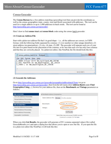
Transcription
Geocoder DocumentationRelease 1.38.1Denis CarriereOct 12, 2018
Contents1Testimonials2API Documentation2.1 API Overview . . . . . . . . . . . . . . . .2.1.1Installation . . . . . . . . . . . . .2.1.2Examples . . . . . . . . . . . . . .2.1.3Error Handling . . . . . . . . . . .2.2 Access to geocoder results . . . . . . . . . .2.2.1[WIP] Multiple results . . . . . . .2.2.2BBox & Bounds . . . . . . . . . .2.3 Refactoring guide to support multiple results2.3.1Changes for OneResult . . . . . . .2.3.2Key changes for the Query manager2.3.3More examples . . . . . . . . . . .2.4 QGIS Field Calculator . . . . . . . . . . . .2.4.1Output Field . . . . . . . . . . . . .2.4.2Function Editor . . . . . . . . . . .2.4.3Expression . . . . . . . . . . . . .5555777101112131415151515Providers3.1 ArcGIS . . . . . . . . . . . . . .3.1.1Geocoding . . . . . . . .3.2 Baidu . . . . . . . . . . . . . . .3.2.1Geocoding . . . . . . . .3.2.2Reverse Geocoding . . .3.3 Bing . . . . . . . . . . . . . . .3.3.1Geocoding . . . . . . . .3.3.2Reverse Geocoding . . .3.4 CanadaPost . . . . . . . . . . . .3.4.1Geocoding (Postal Code)3.5 FreeGeoIP.net . . . . . . . . . .3.5.1Geocoding (IP Address)3.6 Gaode . . . . . . . . . . . . . . .3.6.1Geocoding . . . . . . . .3.7 GeocodeFarm . . . . . . . . . .3.7.1Geocoding . . . . . . . .3.7.2Reverse Geocoding . . .17171718181819192021212222222323232433.i
3.213.223.233.243.25iiGeocoder.ca . . . . . . . . . . . . .3.8.1Geocoding . . . . . . . . . .GeoNames . . . . . . . . . . . . . .3.9.1Geocoding . . . . . . . . . .3.9.2Details (inc. timezone, bbox)3.9.3Children and Hierarchy . . .GeoOttawa . . . . . . . . . . . . . .3.10.1 Geocoding . . . . . . . . . .Google . . . . . . . . . . . . . . . .3.11.1 Geocoding . . . . . . . . . .3.11.2 Reverse Geocoding . . . . .3.11.3 Timezone . . . . . . . . . .3.11.4 Component Filtering . . . .3.11.5 Places . . . . . . . . . . . .3.11.6 Elevation . . . . . . . . . .HERE . . . . . . . . . . . . . . . . .3.12.1 Geocoding . . . . . . . . . .IP Info.io . . . . . . . . . . . . . . .3.13.1 Geocoding (IP Address) . .3.13.2 Geocode your own IP . . . .LocationIQ . . . . . . . . . . . . . .3.14.1 Geocoding . . . . . . . . . .3.14.2 Reverse Geocoding . . . . .Mapbox . . . . . . . . . . . . . . . .3.15.1 Geocoding . . . . . . . . . .3.15.2 Reverse Geocoding . . . . .MapQuest . . . . . . . . . . . . . .3.16.1 Geocoding . . . . . . . . . .3.16.2 Reverse Geocoding . . . . .MaxMind . . . . . . . . . . . . . . .3.17.1 Geocoding (IP Address) . .3.17.2 Geocode your own IP . . . .Opencage . . . . . . . . . . . . . . .3.18.1 Geocoding . . . . . . . . . .3.18.2 Reverse Geocoding . . . . .OpenStreetMap . . . . . . . . . . . .3.19.1 Geocoding . . . . . . . . . .3.19.2 Nominatim Server . . . . .3.19.3 OSM Addresses . . . . . . .Tamu . . . . . . . . . . . . . . . . .3.20.1 Geocoding . . . . . . . . . .TomTom . . . . . . . . . . . . . . .3.21.1 Geocoding . . . . . . . . . .What3Words . . . . . . . . . . . . .3.22.1 Geocoding (3 Words) . . . .3.22.2 Reverse Geocoding . . . . .Yahoo . . . . . . . . . . . . . . . . .3.23.1 Geocoding . . . . . . . . . .Yandex . . . . . . . . . . . . . . . .3.24.1 Geocoding . . . . . . . . . .3.24.2 Reverse Geocoding . . . . .TGOS . . . . . . . . . . . . . . . . .3.25.1 Geocoding . . . . . . . . . 7474848
4Contributor Guide4.1 Authors . . . . . . . . . . . . . . . . . . . . . . . . . . . . . . . . . . . . . . . . . . . . . . . . . .4.1.1Lead Developer . . . . . . . . . . . . . . . . . . . . . . . . . . . . . . . . . . . . . . . . .4.1.2Contributors . . . . . . . . . . . . . . . . . . . . . . . . . . . . . . . . . . . . . . . . . . .49494949iii
iv
Geocoder Documentation, Release 1.38.1Release v1.38.1. (Installation)Simple and consistent geocoding library written in Python.Many online providers such as Google & Bing have geocoding services, these providers do not include Python librariesand have different JSON responses between each other.It can be very difficult sometimes to parse a particular geocoding provider since each one of them have their ownJSON schema.Here is a typical example of retrieving a Lat & Lng from Google using Python, things shouldn’t be this hard. import requests url ' params {'sensor': 'false', 'address': 'Mountain View, CA'} r requests.get(url, params params) results r.json()['results'] location results[0]['geometry']['location'] location['lat'], location['lng'](37.3860517, -122.0838511)Now lets use Geocoder to do the same task. import geocoder g geocoder.google('Mountain View, CA') g.latlng(37.3860517, -122.0838511)Contents1
Geocoder Documentation, Release 1.38.12Contents
CHAPTER1TestimonialsTobias Siebenlist Geocoder: great geocoding library by @DenisCarriere.mcbetz Very good companion for Geocoder. Glad to see Python getting more geo libraries for Non-GIS users.3
Geocoder Documentation, Release 1.38.14Chapter 1. Testimonials
CHAPTER2API DocumentationIf you are looking for information on a specific function, class or method, this part of the documentation is for you.2.1 API Overview2.1.1 InstallationTo install Geocoder, simply: pip install geocoderOr on any of the supported Linux distros: sudo snap install geocoderGitHub InstallInstalling the latest version from GitHub: git clone https://github.com/DenisCarriere/geocoder cd geocoder python setup.py installOr on any of the supported Linux distros: sudo snap install geocoder --edge2.1.2 ExamplesMany properties are available once the geocoder object is created.5
Geocoder Documentation, Release 1.38.1Forward Geocoding .import geocoderg geocoder.google('Mountain View, CA')g.geojsong.jsong.wktg.osmReverse Geocoding .g geocoder.google([45.15, -75.14], method 'reverse')g.cityg.stateg.state longg.countryg.country longHouse Addresses .g geocoder.google("453 Booth Street, Ottawa ON")g.housenumberg.postalg.streetg.street longIP Addresses import geocoderg geocoder.ip('199.7.157.0')g geocoder.ip('me')g.latlngg.cityCommand Line InterfaceBasic usesage with CLI geocode "Ottawa, ON" --provider bingSaving results into a file geocode "Ottawa, ON" ottawa.geojsonReverse geocoding with CLI geocode "45.15, -75.14" --provider google --method reverse6Chapter 2. API Documentation
Geocoder Documentation, Release 1.38.1Using JQ to query out a specific attribute geocode "453 Booth Street" -p canadapost --output json jq .postalUsing a SessionIn case you have several addresses to encode, to use persistent HTTP connection as recommended by the requestlibrary anced/#session-objects you might use the following: with requests.Session() as session: berlin geocoder.google("Ritterstr. 12, 10969 Berlin", session session) ottawa geocoder.google("453 Booth Street, Ottawa ON", session session)2.1.3 Error HandlingIf there is an error in the connection to the server, the exception raised by the requests library will be propagated up tothe caller. This will be an instance of requests.exceptions.RequestException. import geocoder g geocoder.osm("Tower Bridge, London", url "http://nonexistent.example.com")Traceback (most recent call last):.requests.exceptions.ConnectionError: HTTPConnectionPool(host 'nonexistent.example.com ', port 80): Max retries exceeded with url: /?limit 1&format jsonv2& addressdetails 1&q foo (Caused by NewConnectionError(' requests.packages.urllib3. connection.HTTPConnection object at 0x7f6b004d9390 : Failed to establish a new connection: [Errno -2] Name or service not known',))If geocoder was able to contact the server, but no result could be found for the given search terms, the ok attribute onthe returned object will be False. import geocoder g geocoder.osm("Mount Doom, Mordor") g.okFalse g.json{'status': 'ERROR - No results found', 'location': 'Mount Doom, Mordor', 'provider': 'osm', 'status code': 200, 'ok': False, 'encoding': 'utf-8'}2.2 Access to geocoder results2.2.1 [WIP] Multiple resultsAs for now, Geocoder always returns one result: the best match according to the queried provider. import geocoder g geocoder.geonames('Mountain View, CA') g.latlng['37.38605', '-122.08385'](continues on next page)2.2. Access to geocoder results7
Geocoder Documentation, Release 1.38.1(continued from previous page) g.country'United States' g.json.A Work is In Progress to support multiple results (you will find which providers support this feature on the READMEfile).If you would like to contribute and extend your favorite provider, please refer to the Refactoring guideSimply add maxRows in your query: import geocoder g geocoder.geonames('Mountain View, CA', maxRows 5) for result in g:.print(result.address, result.latlng).Mountain View ['37.38605', '-122.08385']Mountain View Elementary School ['34.0271', '-117.59116']Best Western Plus Mountainview Inn and Suites ['51.79516', '-114.62793']Best Western Mountainview Inn ['49.3338', '-123.1446']Mountain View Post Office ['37.393', '-122.07774']Extending without breakingThe objective is to allow access to multiple results, without breaking the lib, neither adding to much complexity. all existing API calls shoul continue to Work access to all results should be easy import geocoder g geocoder.geonames('Mountain View, CA', maxRows 5)# API calls still work on best match g.latlng['37.38605', '-122.08385'] g.country'United States' g.json.# the returned object support len , getitem , iter print(len(g))5 g[3].latlng['49.3338', '-123.1446'] for result in g:.print(result.address, result.latlng).Note that the API calls are done on the best match from the provider, but you can change this behaviour by explicitelysetting the default result to your desired one with the method set default result: g.set default result(3) g.latlng(continues on next page)8Chapter 2. API Documentation
Geocoder Documentation, Release 1.38.1(continued from previous page)['49.3338', '-123.1446'] g.address'Best Western Plus Mountainview Inn and Suites'“Breaking” changeThe geojson property called on g will not apply to the best match anymore, as it would for all others providers andpropertiese.g. provider not supporting multiple results: import geocoder g geocoder.google('Mountain View, CA') :'Mountain View, CA, USA',.},'bbox':[.],'geometry':{.}}Instead, the geojson property will apply to all results, therefore returning a FeatureCollection of all Features: import geocoder g geocoder.geonames('Mountain View, CA', maxRows 2) 'type':'Feature','properties':{'address':'Mountain ties':{'address':'Mountain View Elementary School',.},'geometry':{.}}]}More ?The returned object g is a MutableSequence (python 3.3) because you might be interested in the actual order of theresults given back by the provider, e.g. when querying the its hierarchy:2.2. Access to geocoder results9
Geocoder Documentation, Release 1.38.1 import geocoder main geocoder.geonames('Mountain View, CA') g geocoder.geonames(main.geonames id, method 'hierarchy') for result in g:.print(result.address, result.latlng).Earth ['0', '0']North America ['46.07323', '-100.54688']United States ['39.76', '-98.5']California ['37.25022', '-119.75126']Santa Clara County ['37.23249', '-121.69627']Mountain View ['37.38605', '-122.08385']2.2.2 BBox & BoundsOverviewSome Geocoder results will contain a BBox/Bounds of the geographical extent of the result. There are two differentwidely adopted formats: Bounds: An Object defined which was first implemented by Google Maps API and adopted by many otherproviders such as Leaflet.{northeast: [north, east],southwest: [south, west]} BBox: An Array of 4 numbers which follows the GeoJSON BBox specification.[west, south, east, north]The major difference between both is the coordinates are flipped (LatLng LngLat).How to useBBox or Bounds can be used in geocoding queries to limit the search to the given area. The two formats are accepted.Let’s look at a basic search for ‘Paris’ import geocoder g geocoder.geonames('Paris', maxRows 3, key ' USERNAME ') print([(r.address, r.country, r.latlng) for r in g])[ ('Paris', 'France', ['48.85341', '2.3488']),('Paris', 'United States', ['33.66094', '-95.55551']),('Paris', 'Denmark', ['56.51417', '8.48996'])]Now, if you are not interested in any of those matches, you might have an hard time to find yours. That’s whereproximity comes into play.Let’s assume for the sake of this example that you are seeking ‘Paris’ nearby [43.2, -80.3]. You just need to defineyour bbox, or your bounds, and use the ‘proximity’ parameter. . .10Chapter 2. API Documentation
Geocoder Documentation, Release 1.38.1 bounds {'southwest': [43.0, -80.5],'northeast': [43.5, -80.0]} g geocoder.geonames('Paris', proximity bounds, key ' USERNAME ') print([g.address, g.country, g.latlng])['Paris', 'Canada', ['43.2001', '-80.38297']]# let's do the same with bounds bbox [-80.5, 43.0, -80.0, 43.5] g geocoder.geonames('Paris', proximity bbox, key ' USERNAME ') print([g.address, g.country, g.latlng])['Paris', 'Canada', ['43.2001', '-80.38297']]Actually, you can even just use a couple of (lat, lng) and the box will be created with a tolerance of 0.5 degrees in thefour directions (west, south, east, north) latlng [43.0, -80.0] g geocoder.geonames('Paris', proximity latlng, key ' USERNAME ') print([g.address, g.country, g.latlng])['Paris', 'Canada', ['43.2001', '-80.38297']]Compliant providers Google Places Geonames Mapbox2.3 Refactoring guide to support multiple resultsIt basically comes to split the existing classes into two new ones OneResult handles all the properties of one given result from the provider MultipleResultsQuery handles the query to the provider, and provides the interface to iterate through the results:# from geocoder.base import Base## class Baidu(Base):#provider 'mapquest'#method 'geocode'##def init (self, location, **kwargs):#.##@property#def lat(self):#return self.parse['location'].get('lat')## becomesfrom geocoder.base import OneResult, MultipleResultsQuery(continues on next page)2.3. Refactoring guide to support multiple results11
Geocoder Documentation, Release 1.38.1(continued from previous page)class BaiduResult(OneResult):@propertydef lat(self):return self.raw['location'].get('lat')class BaiduQuery(MultipleResultsQuery):provider 'mapquest'method 'geocode'.2.3.1 Changes for OneResultIt is important to keep in mind that OneResult handles all the properties for one given result from the provider. Themodifications you will need to do here are the ones that impact one result only, not the overall process of the query. The JSON returned from the provider moved from self.parse to self.raw:class MapquestResult(OneResult):@propertydef lat(self):return self.raw['latLng'].get('lat')@propertydef lng(self):return self.raw['latLng'].get('lng'). The constructor init takes the json content corresponding to this result (and only this one). You mightchange it before storing it in self.raw:class GoogleResult(OneResult):def init (self, json content):# do some transformation.# proceed with super. initsuper(GoogleResult, self). init (json content)or, with Mapbox:class MapboxResult(OneResult):def init (self, json content):super(MapboxResult, self). init (json content)for item in json content.get('context', []):if '.' in item['id']:# attribute country & text Canadaattribute item['id'].split('.')[0]self.raw[attribute] item['text']12Chapter 2. API Documentation
Geocoder Documentation, Release 1.38.1 the ok property should be overriden on the result level when necessary (which is usually the case when you wantto reverse):class GoogleReverseResult(GoogleResult):@propertydef ok(self):return bool(self.address)2.3.2 Key changes for the Query managerHere, it is important to keep in mind that MultipleResultsQuery handle the overall process of the query, and stores allthe results. The responsabilities here are to1. setup the context correctly2. make the query with appropriate headers, params3. parse the response from the provider and create results appropriatlyLet’s detail those three steps (Setup) The first modification will be to provide the metadata needed for the query, namely:– what class to use for the result– what url to query– which key to useclass MapquestQuery(MultipleResultsQuery):URL ESULT CLASS MapquestResultKEY mapquest keyKEY MANDATORY TrueBecause the default implementation expects an API Key, you will need to set KEY MANDATORY to False if no API Key is required (Query) In order to make the query: the initialization of the params & headers is not done neither in theconstructor anymore but in the appropriated hooks. As you can see, location and provider key are passedthrough:def build headers(self, provider key, **kwargs):return {'referer': 'http://www.mapquestapi.com/geocoding/','host': 'www.mapquestapi.com',}def build params(self, location, provider key, **kwargs):return {'key': provider key,'location': location,'maxResults': kwargs.get("maxRows", 1),'outFormat': 'json',}2.3. Refactoring guide to support multiple results13
Geocoder Documentation, Release 1.38.1 (Query) In some cases (e.g reversing), you need more preparation before you can build your headers / params.You would use before initialize for this, which is called before connecting to the provider. A typical use-caseis where URL is dynamic and needs to be extended at runtime:class MapboxReverse(MapboxQuery):def before initialize(self, location, **kwargs):self.location str(Location(location))lat, lng Location(location).latlngself.url self.url.format(lng lng, lat lat) (Parsing) The treatment of the json response, which probably contains multiple results, is not done in theconstructor anymore, it is done through the following hooks:def catch errors(self, json response):if b'The AppKey submitted with this request is invalid' in json response:raise ValueError('MapQuest API Key invalid')def adapt results(self, json response):results json response.get('results', [])if results:return results[0]['locations']return [] (Parsing) In the cases where you are interested in some fields in the json response, additionnaly to the results,you might want to override parse results. In which case you should also declare the new attribute in your childclass. There is one example with GooglePlaces, where the next page token interests us:class PlacesQuery(MultipleResultsQuery):def init (self, location, **kwargs):super(PlacesQuery, self). init (location, **kwargs)self.next page token None.def parse results(self, json response):super(PlacesQuery, self). parse results(json response)# store page token if anyself.next page token json response.get('next page token')2.3.3 More examplesPlease have a look on the providers already “migrated”, like geonames bing mapbox mapquestThe full list is available on the README14Chapter 2. API Documentation
Geocoder Documentation, Release 1.38.12.4 QGIS Field CalculatorUsing the QGIS Field Calculator this will output WKT format.2.4.1 Output Field Name: wkt Type: Text, unlimited length (text)2.4.2 Function Editorimport geocoder@qgsfunction(group 'Geocoder')def geocode(location, feature, parent):g geocoder.google(location)return g.wkt2.4.3 ExpressionFind the geocode expression in the Geocoder function list, the final result will look something like this:geocode("address")Once the wkt field is added, you can then save your document as a CSV format and in the Layer Options define theGEOMETRY AS WKT.2.4. QGIS Field Calculator15
Geocoder Documentation, Release 1.38.116Chapter 2. API Documentation
CHAPTER3ProvidersDetailed information about each individual provider that are within Geocoder.3.1 ArcGISThe World Geocoding Service finds addresses and places in all supported countries from a single endpoint. Theservice can find point locations of addresses, business names, and so on. The output points can be visualized on amap, inserted as stops for a route, or loaded as input for a spatial analysis. an address, retrieving imagery metadata, orcreating a route.3.1.1 Geocoding import geocoder g geocoder.arcgis('Redlands, CA') g.json.This provider may return multiple results by setting the parameter maxRows to the desired number (1 by default). Youcan access those results as described in the page ‘Access to geocoder results’.Command Line Interface geocode 'Redlands, CA' --provider arcgisParameters location: Your search location you want geocoded. maxRows: (default 1) Max number of results to fetch17
Geocoder Documentation, Release 1.38.1 limit: Deprecated, same as maxRows method: (default geocode) Use the following:– geocodeReferences ArcGIS Geocode API3.2 BaiduBaidu Maps Geocoding API is a free open the API, the default quota one million times / day.3.2.1 Geocoding import geocoder # pip install geocoder g geocoder.baidu('', key ' API KEY ') g.json.3.2.2 Reverse Geocoding .import geocoderlatlng [45.3, -105.1]g geocoder.baidu(latlng, method 'reverse', key ' API KEY ')g.jsonCommand Line Interface geocode '' --provider baiduEnvironment VariablesTo make sure your API key is store safely on your computer, you can define that API key using your system’s environment variables. export BAIDU API KEY Secret API Key export BAIDU SECURITY KEY Secret API Security Key Parameters location: Your search location you want geocoded. key: Baidu API key. sk: Baidu API security key. Use with key. For Baidu developers.18Chapter 3. Providers
Geocoder Documentation, Release 1.38.1 method: (default geocode) Use the following:– geocode– reverseReferences API Reference Get Baidu key Signature algorithm3.3 BingThe Bing Maps REST Services Application Programming Interface (API) provides a Representational State Transfer (REST) interface to perform tasks such as creating a static map with pushpins, geocoding an address, retrievingimagery metadata, or creating a route. Using Geocoder you can retrieve Bing’s geocoded data from Bing Maps RESTServices.3.3.1 Geocoding import geocoder # pip install geocoder g geocoder.bing('Mountain View, CA', key ' API KEY ') g.json.This provider may return multiple results by setting the parameter maxRows to the desired number (1 by default). Youcan access those results as described in the page ‘Access to geocoder results’. If you want to search using a structuredaddress, use the detailed method. import geocoder # pip install geocoder g geocoder.bing(None, locality 'Ottawa', adminDistrict 'Ontario', method 'details', key ' API KEY ') g.json.This provider gives access to batch geocoding services that allow you to geocode multiple addresses at the same time.The amount of addresses you can geocode at once depends on the kind of key you have. It is described on BingGeocode Limits. import geocoder g geocoder.bing(['Mountain View, CA', 'Boulder, Co'], method 'batch') for result in g:.print(result.latlng).[37.39008, -122.08139][40.015831, -105.27927].3.3. Bing19
Geocoder Documentation, Release 1.38.13.3.2 Reverse Geocoding import geocoder g geocoder.bing([45.15, -75.14], method 'reverse') g.json.Batch reverse geocoding is also available through the batch reverse method: import geocoder g geocoder.bing([[40.7943, -73.970859], [48.845580, 2.321807]], method 'batch reverse') for result in g:.print(result.address, result.city, result.postal, result.state, result.country).('208 W 96th St, New York, NY 10025', 'New York', '10025', 'NY', 'United States')('114B Rue de Vaugirard, 75006 Paris', 'Paris', '75006', 'Ile-de-France', 'France').Command Line Interface geocode 'Mountain View, CA' --provider bing geocode '45.15, -75.14' --provider bing --method reverseEnvironment VariablesTo make sure your API key is store safely on your computer, you can define that API key using your system’s environment variables. export BING API KEY Secret API Key Parameters location: Your search location you want geocoded. addressLine: (method details) Official street line, uses location if not provided. postalCode: (method details) The post code, postal code, or ZIP. locality: (method details) The locality, such as the city or neighborhood. adminDistrict: (method details) The subdivision name in the country of region for an address. countryRegion: (method details) The ISO country code for the country. key: use your own API Key from Bing. maxRows: (default 1) Max number of results to fetch method: (default geocode) Use the following:– geocode– details– reverse20Chapter 3. Providers
Geocoder Documentation, Release 1.38.1– batch– batch reverseReferences Bing Maps REST Services Bing Geocode Limits3.4 CanadaPostThe next generation of address finders, AddressComplete uses intelligent, fast searching to improve data accuracy andrelevancy. Simply start typing a business name, address or Postal Code and AddressComplete will suggest results asyou go. Using Geocoder you can retrieve CanadaPost’s geocoded data from Addres Complete API.3.4.1 Geocoding (Postal Code) import geocoder g geocoder.canadapost('453 Booth Street, Ottawa', key ' API KEY ') g.postal'K1R 7K9' g.json.This provider may return multiple results by setting the parameter maxRows to the desired number (1 by default). Youcan access those results as described in the page ‘Access to geocoder results’.Command Line Interface geocode '453 Booth Street, Ottawa' --provider canadapost jq .postalEnvironment VariablesTo make sure your API key is store safely on your computer, you can define that API key using your system’s environment variables. export CANADAPOST API KEY Secret API Key Parameters location: Your search location you want geocoded. key: (optional) API Key from CanadaPost Address Complete. language: (default en) Output language preference. country: (default ca) Geofenced query by country. maxRows: (default 1) Max number of results to fetch3.4. CanadaPost21
Geocoder Documentation, Release 1.38.1 method: (default geocode) Use the following:– geocodeReferences Addres Complete API3.5 FreeGeoIP.netfreegeoip.net provides a public HTTP API for software developers to search the geolocation of IP addresses. It uses adatabase of IP addresses that are associated to cities along with other relevant information like time zone, latitude andlongitude.You’re allowed up to 10,000 queries per hour by def
Simple and consistent geocoding library written in Python. Many online providers such as Google & Bing have geocoding services, these providers do not include Python libraries and have different JSON responses between each other. It can be very difficult sometimes to parse a particular geocoding provider since each one of them have their own