Transcription
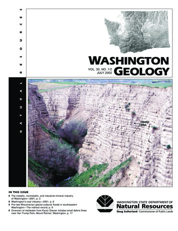
SECRUESOVOL. 30, NO. 1/2JULY 2002NATURALRWASHINGTONGEOLOGYIN THIS ISSUEz The metallic, nonmetallic, and industrial mineral industryof Washington—2001, p. 3z Washington’s coal industry—2001, p. 8z Pre-late Wisconsinan glacial outburst floods in southeasternWashington—The indirect record, p. 9z Diversion of meltwater from Kautz Glacier initiates small debris flowsnear Van Trump Park, Mount Rainier, Washington, p. 17clasticdike
WASHINGTONGEOLOGYVol. 30, No. 1/2July 2002Washington Geology (ISSN 1058-2134) is published four times a year on the webby the Washington Division of Geology and Earth Resources.WASHINGTON DIVISION OF GEOLOGY AND EARTH RESOURCESRonald F. Teissere, State GeologistDavid K. Norman, Assistant State GeologistGeologists (Olympia)Environmental Geology SectionTimothy J. Walsh (head)Patrick T. PringleSammantha MagsinoStephen P. PalmerKarl W. WegmannGeology and Resources SectionJosh (Robert L.) Logan (head)Joe D. DragovichWilliam S. Lingley, Jr.Michael PolenzHenry W. (Hank) SchasseWeldon W. Rau (emeritus)J. Eric Schuster (emeritus)Regulatory SectionChris Johnson (head)Matt BrookshierGeologists (Spokane)Robert E. DerkeyMichael M. Hamilton (volunteer)Mine Inspectors (Regions)Garth Anderson (Northwest)Brad Campbell (Southwest)Charles W. (Chuck) Gulick (Northeast)Russ Holt (Olympic)Dave Pierce (South Puget Sound)Lorraine Powell (Southeast)Carol Serdar (Central)MAIN OFFICEWashington Division of Geologyand Earth ResourcesPO Box 47007Olympia, WA 98504-7007Digital cartography nie J. Manson (senior librarian)Lee WalklingEditorsJaretta M. (Jari) Roloff (senior editor)Karen D. MeyersCartographersChuck Caruthers (senior cartographer)Anne HeinitzKeith G. IkerdProject StaffDonald T. (Mac) McKay, Jr.Fritz WolffColin Wright (intern)Ryan D. Gold (intern)Regulatory StaffHoa LeCindy PrestonMary Ann ShawverOffice Support StaffJanis G. Allen (supervisor)Diane FredericksonTara SalzerConclusions and opinions presented inarticles are those of the authors and arenot necessarily endorsed by the Washington State Department of NaturalResources.Phone: (360) 902-1450Fax: (360) 902-1785E-mail: geology@wadnr.govWebsite: http://www.wa.gov/dnr/htdocs/ger/Copying and reprinting of articles isencouraged (just acknowledge Washington Geology and the authors as thesource), unless it says ‘copyrighted’,‘used by permission’, or ‘courtesy of’.Then you need permission of the authoror publisher to use it.Library inquiries:connie.manson@wadnr.gov orlee.walkling@wadnr.govEditorial inquiries:jari.roloff@wadnr.govUnion Ave.mPluSt.St.Franklin StWashingtonToDowntown OlympiaStateCapitolH14thAve.EXIT105ACap5Maple Park Ave.itolLakeStreet Address:Division of Geology and Earth ResourcesNatural Resources Bldg., Room 1481111 Washington St. S.E.Olympia, WA 98501ToPortl andVisitor parking (VP) is available onLevel P1 at .50/hour. Use theWashington St. n St.Capitol Way11th Ave.VPEXIT105HendersonBlvd.Washington Geology, vol. 30, no. 1/2, July 2002Division UpdateThe Division has been going through many changes—somegood, some bad, some.who knows?One ‘good thing’ is that we have finally published the geologic map of the Northwest Quadrant. The four-color mapcomes folded in a 9½ x 12-inch envelope containing a 76-pagepamphlet and three plates: the geologic map, the descriptionsof map units, and ages of map units. The map is the result of amulti-year effort by geologists of the Washington Division ofGeology and Earth Resources with assistance from geologistsfrom the U.S. Geological Survey, several Washington universities, and the local geological community.The map is dedicated to Dr. Rowland W. Tabor (USGS, retired), who is the principal author of mapping that covers approximately three quarters of the northwest quadrant. Over thelast 40 years, he has published 28 peer-reviewed technicalbooks and articles and made dozens of presentations at professional conferences. Without this work, large parts of the Cascades and Olympics would still be poorly understood.The release of this fourth and final map completes the set ofquadrant maps comprising the geologic map of Washington at1:250,000-scale. The previous quadrant maps were publishedin 1987 (southwest), 1991 (northeast), and 1997 (southeast).The approximately 4½ x 3-foot individual quadrants makea colorful wall display when mounted separately or together.Copies of the northwest quadrant may be purchased for 9.20 .80 tax (Wash. residents only) 10.00 per copy ( 11.12 .88 12.00 for a flat map in a tube) plus shipping and handling( 3.50 folded; 4.50 flat).Another good thing is that we have reissued the color pagesize geologic map of Washington and the Mount St. Helensroad guide, which has been out of print for a while. The maphas a new summary of the geology of Washington on the back,and the text of the road guide has been updated and several newphotos have been added.Continuing budgetary shrinkage has caused several badthings to happen. First, as of July 1, 2002, the Spokane Officeis officially closed, although Bob Derkey will continue to workon mapping projects in the area through at least the next year.Second, to cover our actual costs for printing and mailing,we have had to increase the prices of some open file reports andthe cost of shipping and handling for all publication orders.(See p. 20 for more information.)And third, with this issue, Washington Geology becomes aweb-only publication, which means it will no longer be sentout free to subscribers, but it will be available on our website.Many other state surveys have been forced to take this costcutting measure. We regret that we do not currently have thecapability to notify people by e-mail when the next issue comesout.We will be running a certain number of xerographic copiesfor distribution to libraries and anyone who wishes to buy one.They won’t have the quality of a printed copy, but they will beon high-quality 11x17² paper, saddle-stitched, and quite readable. To order a paper copy of Washington Geology, send 1.50 per issue plus 2.50 for shipping and handling. nCover photo: Outcrop of late Pleistocene Touchet beds (pronouncedtoo -she) in Burlingame ravine near Walla Walla, Washington. Each gradedbed represents a flood event within the latest Pleistocene catastrophic glacial outburst flood sequence—the Missoula floods. Note the vertical clasticdike in right center of photo. See article on p. 9. (Photo by P. K. Spencer.)
The Metallic, Nonmetallic, and IndustrialMineral Industry of Washington—2001119o120oRobert E. Derkey and Michael M. HamiltonWashington Division of Geology and Earth Resources904 W. Riverside Ave., Room 215; Spokane, WA 99201-1011e-mail: HOProduction of nonfuel mineral commodities in Washington in2000 was valued at 607,000,000 (U.S. Geological Survey andWashington Division of Geology and Earth Resources, 2002).This represents nearly a 4 percent decrease from 1999. Firmnumbers for 2001 are not yet available. Metallic mineral production accounted for approximately 21 percent of the value ofnonfuel mineral production. Nonmetallic mineral commoditieslimestone, dolomite, shale, clay, diatomite, olivine, and silicaaccounted for approximately 22 percent, a small increase over1999. When available, figures for nonmetallic mineral production in 2001 are expected to be lower. Industrial minerals (aggregate) accounted for approximately 57 percent of the totalvalue of the state’s mineral production in 2000.This article is a summary of mining company activities in2001 based on a telephone survey by the Department of NaturalResources in January and February of 2002. Location maps(Figs. 1 and 5) and summary tables (Tables 1 and 2) are provided for both metallic and nonmetallic mineral operations. Allof the larger known mining operations were contacted, but because some, especially the smaller, operations were not, thisreport does not contain a complete listing of mineral industryactivities in the state. However, the major mining operationscontribute the majority of the value of the State’s nonfuel mineral production.Additional details about the geology of mineral depositsand earlier industry activities in the State are available in TMAN118o47o117oFigure 1. Location of major metal mining projects in northeasternWashington in 2001. Table 1 below identifies mines by number given onmap and provides additional details about each of these projects.reviews of the Washington mineral industry published in thefirst issue of Washington Geology each year (Derkey, 1998,1999; Derkey and Hamilton, 2000, 2001). Questions about metallic and nonmetallic mining activities and exploration shouldbe referred to the Olympia office.Table 1. Operator and brief description of the activity and geology at major metallic mineral deposits in Washington in 2001 (companion to Fig. vityArea geology1Lamefootsecs. 4, 8,T37N R33EFerryAu, AgEcho BayMineralsCo.A small tonnage of ore was recovered duringshutdown of the mine last summer; 74,693 tonsof stockpiled Lamefoot ore containing 12,818 ozof gold was processed at the mill near the Overlook mine; gold recovery was approximately 85%Gold mineralization in massiveiron exhalative/replacementmineralization in Triassicsedimentary rocks2K-2sec. 20,T39N R33EFerryAu, AgEcho BayMineralsCo., KettleRiverProjectMined 221,547 tons of ore from the K-2 deposit Epithermal deposit in Eocenethat contained 44,225 oz of gold; 265,192 tons of Sanpoil VolcanicsK-2 ore was milled containing 47,800 oz ofgold; company conducted 15,000 ft ofexploratory surface drilling adjacent to the K-2deposit3CrownJewelsec. 24,OkanoganT40N R30EAu, Cu,Ag, FeCrownResourcesCorp.Battle Mountain Gold, which merged withNewmont Mining, dropped its option onthe deposit; Crown Resources is now exploringthe possibility of developing the deposit as anunderground mineGold skarn mineralization inPermian or Triassic metasedimentary rocks adjacentto the Jurassic–Cretaceous(?)Buckhorn Mountain pluton4PendOreilleminesecs. 10, 11,14, 15,T39N R43EPendOreilleZn, Pb,Ag, CdTeckComincoAmerican,Inc.Continued permitting process; tailings disposalsite prepared; planning to sink internal shaftfrom 900 level to Yellowhead ore horizon in2002; mining startup delayed until 2004Mississippi Valley-typemineralization in Yellowheadzone of Cambrian–OrdovicianMetaline FormationAddysecs. 13-14,Magnesium T33N R39EmineStevensMg5Northwest After 30 years of operation, the AddyAlloys, Inc. magnesium metal operation was discontinued inSeptember 2001 because of depressed metalprices; there are no plans by parent companyAlcoa to reopen the operationCambrian–Ordovician MetalineFormation dolomiteWashington Geology, vol. 30, no. 1/2, July 20023
LedbetterSlateOrdovicianMETALLIC MINERAL rMiddleMetaline FormationCambrian–OrdovicianUppercarbonaceous argilliteMajor metal mining operations in Washingtonin the year 2001 included gold mining at RepubJosephinelic and magnesium metal production at Addy.There will be a dramatic decrease in activity in2002, as magnesium metal operations at Addywere closed down in September of 2001. Workto reopen the Pend Oreille lead-zinc mine conmassive gray limestonedolomitetinued; however, Teck Cominco American haselected to delay startup of the mine until 2004due to depressed zinc prices. Battle MountainGold became a wholly owned subsidiary ofYellowhead 1Newmont Mining and elected to drop theiroption for the Crown Jewel gold deposit. Theonly major known exploration project for metalperitidal dolomitelic minerals in Washington in 2001 was for additional reserves in and adjacent to the K-2 golddeposit. Locations of metallic mineral properYellowhead 2ties active in 2001 are shown on Figure 1. Thenumber in parentheses following each propertyname below is the number on the location map.peritidal dolomiteMining by Echo Bay Minerals at the KettleRiver Project was at the K-2 mine (2), an epithermal vein-type deposit in Eocene volcanicFigure 2. Schematic representation of stratigraphy at the Pend Oreille mine in the midrocks of the Republic graben north of Republicdle and upper Metaline Formation and overlying Ledbetter Slate. Horizons where minerin Ferry County. The company mined 221,547alization occurs are shown relative to stratigraphic position. (Modified from Teck Comintons of ore (44,225 ounces of contained gold)co website.)from the K-2 deposit. The company milled265,192 tons (47,798 ounces of contained gold)of K-2 ore (including stockpiled ore) and 74,693 tons (12,818ounces of contained gold) of stockpiled ore from the Lamefootmine (1). Mining was completed in 2000 at the Lamefoot mine;however, a small tonnage was removed during rehabilitationoperations in 2001. Total gold recovered from K-2 and LamePend Oreille mine areafoot ores was 50,349 ounces from 339,885 tons of ore; recovery was approximately 85 percent. Because haulage distancesare greater and mining costs are higher, the company expectsK-2 production will decrease to 35,000 ounces of gold in 2002.Echo Bay continued to explore for mineralization to maintain their reserves in the Republic area. Their focus was northeast of the K-2 mine where they completed approximatelyshaft15,000 feet of drilling from the surface northeast of the mine.Drilling had not progressed sufficiently at the end of the year toallow the company to classify this resource as proven and probable reserves. They plan to continue drilling next year in ordermine portalto prove this reserve.mine plantCanada-based Teck Corporation completed the acquisitionof Cominco during 2001. The company is now known in theU.S. as Teck Cominco American, Inc. In 2001, the companyprepared the tailings disposal site at the Pend Oreille mine (4)in anticipation of resuming mining. They plan to rehabilitateand modernize the old mill on the property and will ship conWashingtonRock areacentrates to their smelter in Trail, B.C., which is about 40 milesfrom the mine. Teck Cominco American has been workingwith local citizens to reduce the mine’s impact on northernPend Oreille County, both during startup and during closure after reserves are depleted. On their website (http://www.500 .htm), TeckCominco reports an ore reserve of 5.5 million tons containing7.3 percent zinc and 1.3 percent lead. They have projected a10-year mine life at about 800,000 tons mined per year. MostFigure 3. Projection of Yellowhead-type mineralization to the surfaceof the approximately 14 million tons of previous production,in the Washington Rock and Pend Oreille mine areas relative to thegrading 2.3 percent zinc and 1.1 percent lead, came from thePend Oreille River. Thick northeast–trending line is location of crossJosephine horizon. The new reserve at the mine is from asection on Figure 4. (Modified from Teck Cominco website.)4Washington Geology, vol. 30, no. 1/2, July 2002
Washington Rock areaPendOreilleRivermine plantmine portalYellowhead 1Pend Oreille Mine areaJosephineYellowhead 2?500 metersYellowhead 1shaftYellowhead 2Figure 4. Washington Rock area to Pend Oreille mine area long section, looking northwest. Location of mineralized zones relative to the mineplant are depicted. Decline that descends from the mine portal to the Yellowhead 1 ore zone is not depicted on this section. Location of section isshown on Figure 3. (Modified from Teck Cominco website.)deeper zone called the Yellowhead 1 zone. They have alsoidentified a third ore horizon, which they refer to as the Yellowhead 2.Zinc and lead deposits in Cambrian–Ordovician carbonatehost rocks, such as at the Pend Oreille mine, are known in theU.S. as Mississippi Valley-type deposits. Teck Cominco callsthem Irish-type deposits. The following is a portion of the information from the Teck Cominco website. “Yellowhead-typemineralization occurs in the middle part of the 1000 metrethick Cambro–Ordovician Metaline Formation in a shallowwater dolomitic facies. Josephine-type mineralization, whichwas exploited by earlier operators, occurs at the top of the upper Metaline Formation, which consists primarily of subtidalcarbonate facies overlain by carbonaceous argillite of the Ordovician Ledbetter Formation.” See Figures 2-4 for a graphicview of the deposit distribution and characteristics. The Yellowhead ore zone is described as “NE trending en-echelonlenses that vary from 150 to 580 metres long. Overall the zoneis 2100 metres long and varies in width from 100 to 200 metresYellowhead-type mineralization is stratabound and consists ofmassive- and coloform-textured pyrite with later bands andcrusts of pale tan to yellow sphalerite. Coarse galena occurswith sparry dolomite in interstices, between masses of sphalerite and pyrite. Mineralization is superimposed on areas ofcoarse zebra-banded dolomite and dolomite-altered stratabound solution collapse breccia. The ore shows local silicification. Thicknesses in the drilled resource average 6 metres butcan reach over 20 metres. Several stratigraphic levels containYellowhead-type mineralization.”Following their merger with Newmont Mining, BattleMountain Gold dropped their option on the Crown Jewel golddeposit (3) near Chesaw in Okanogan County. Crown Resources Corporation is now the sole owner of the deposit. It is askarn-type gold deposit in a sequence of Pennsylvanian to Triassic(?) clastic and carbonate sedimentary rocks adjacent tothe Buckhorn Mountain pluton. Previously announced open pitminable reserves for the deposit were 8.7 million tons at agrade of 0.186 ounces of gold per ton. Crown Resources nowproposes mining the deposit primarily as an underground operation and has recalculated the reserves. They report proven andprobable reserves of 2.56 million tons at a grade of 0.345ounces per ton gold (0.9 million ounces of contained gold) andan additional 0.5 million tons of possible ore at a grade of 0.383ounces per ton gold (0.5 million ounces of contained gold).Northwest Alloys ceased magnesium metal production inSeptember at its plant near Addy (5) in Stevens County. Thecompany was no longer able to compete with lower priced for-eign sources. They, however, mined 670,000 tons of dolomitein 2001 compared to 634,000 tons in 2000. In addition to usingreject material from the mine for road aggregate, the companyprocessed some of their by-product for fertilizer (see below).They will continue that process until the by-product material isexpended. Research continued into finding ways to use theirremaining waste materials.NONMETALLIC MINERAL INDUSTRYNonmetallic mineral commodities produced in Washingtonwere used as smelter flux, soil conditioners, feed lime, landscape rock, paper filler, bricks, cement and fiber cement additives, filter material, casting sand, and glass. The number in parentheses following each property name below is the numberon the location map in Figure 5.Two companies mined limestone (calcium carbonate) anddolomite (calcium magnesium carbonate) for use as a soil conditioner and feed lime in 2001. Pacific Calcium produced fromthe Tonasket (110) and Brown (111) quarries in OkanoganCounty, and Allied Minerals produced from the Gehrke quarry(117) in Stevens County. Northwest Alloys sold approximately11,500 tons of smelter slag from their magnesium metal operation at Addy (123) in Stevens County for fertilizer and soil conditioner. Columbia River Carbonates continued to produce calcium carbonate from the Wauconda quarry (112) and shipped itto their processing plant in Longview, Cowlitz County; most isused as a coating agent to produce glossy paper. NorthportLimestone mined limestone from the Sherve quarry (122) inStevens County, and shipped most of it to Trail, B.C. for use asa fluxing agent in smelting. Northwest Marble Products (120)and the Whitestone Company (119), both in Stevens County,continued to produce terrazzo tile and building aggregates, asthey have for a number of years.Celite Corporation mined and processed approximately100,000 tons from the diatomite pits (102) in Grant County.The company shipped approximately 65,000 tons of finisheddiatomite; most is used for filtration purposes.Olivine Corporation mined 40,000 tons of refractory-gradeolivine from its Swen Larsen quarry (125) in Whatcom Countyin 2001. Most of that production was shipped to Unimin, a Belgian company that produces casting sands and other refractoryproducts at Hamilton, in Skagit County. The company also reports that initial investigation to produce ornamental olivineappears successful; the olivine polishes very well.Mutual Materials used about 102,600 tons of clay for themanufacture of bricks and related products at their plants in SeWashington Geology, vol. 30, no. 1/2, July 20025
Figure 5. Location of nonmetallic mining operations in Washington in 2001. Table 2 below identifies mines by number given on map and providesadditional details about each of these projects.Table 2. Operator and brief description of the activity and geology of nonmetallic mining operations in Washington in 2001 (companion to Fig. astleRockquarrysec. 18,T10N R1WCowlitzclay102Celitediatomitepitssec. 3,T17N R23E;sec. 7,T17N R24EGrantdiatomite103 Ravensdalepitsec. 1,T21N R6EKingsilicaReserve Silica Mined and washed 120,000 tons andCorp.shipped 78,000 tons of silica sand;most used to manufacture glass in theSeattle areaSandstone of the Eocene PugetGroup104sec. 34,T22N R7EKingshaleMutualMaterials Co.Hauled 3,000 tons from stockpile tomanufacture bricksIllite- and kaolinite-bearing shales ofthe Eocene Puget Group105 Section 31pitsec. 31,T24N R6EKingshaleMutualMaterials Co.Mined and hauled 45,000 tons of shaleused to produce bricksShale of the Eocene Puget Group106Spruceclaimsecs. 29-30,T24N R11EKingcrystals107Superiorquarrysec. 1,T19N R7EKingsilicaAsh GroveCement Co.sec. 12,T21N R6EKingclayPacific CoastCoal Co.Elk pit108 John HenryNo. 16ActivityArea geologyAsh GroveCement Co.Mined 15,000 tonsEocene–Oligocene sedimentaryrocksCelite Corp.Mined approximately 100,000 tons ofore and produced 65,000 tons offinished diatomite used primarily forfiltrationMiocene “Quincy diatomite bed”,local sedimentary interbed at thebase of Priest Rapids Member,Columbia River Basalt GroupRobert Jackson Extracted mineral and crystalspecimens from the Spruce 16 claimWashington Geology, vol. 30, no. 1/2, July 2002Quartz and pyrite crystals in abreccia pipe and open voids alongfaulted megabreccia in the northernphase granodiorite and tonalite (25Ma) of the Snoqualmie batholithMined 110,000 tons of silica for use incement manufactureSilica cap in hydrothermally alteredMiocene andesites on a calderamarginNot active in 2001Upper middle Eocene silty clay nearbase of Puget Group in a 30-ft-thickzone above the Franklin No. 9 coalseam
tyArea geology109ScatterCreek minesecs. 5-6,T19N R8EKingSilicaJames HardieBuildingProducts, Inc.Mined 120,000 tons of silicifiedandesite used to manufacture fibercement products; also shipped 20,000tons to Lafarge Corp. for cementmanufactureCap rock material from hydrothermally altered and silicifiedandesite of an igneous complex110Tonasketlimestonequarrysec. 25,OkanoganT38N R26ElimestonePacificCalcium, Inc.Mined 12,335 tons of limestone for soil Metacarbonate rocks in theconditioner and feed limeconglomerate-bearing memberof the Permian Spectacle Formation(Anarchist Group)111Brownquarrysec. 26,OkanoganT35N R26EdolomitePacificCalcium, Inc.Mined 6,960 tons of dolomite used forsoil conditionerMetadolomite member of theTriassic Cave Mountain Formation112 Waucondaquarrysec. 13,OkanoganT38N R30ElimestoneColumbia River Continued mining high-brightnessCarbonatescalcium carbonate; shipped toprocessing plant near Longview; usedas filler in paper, paint pigments, andin plasticsHigh-calcium, pre-Tertiary whitemarble lenses in mica schist, calcsilicate rocks, and hornfels113Clay Citypitsec. 30,T17N R5EPierceclayMutualMaterials Co.Mined 3,150 tons; used 5,480 tons toproduce bricks114Usk pitsec. 7,T32N R44EPendOreilleclayMutualMaterials Co.Mined 4,510 tons of clay-rich material, Holocene lacustrine deposits of clay,which they used to produce brickssilt, and sand; light gray clay firesdark red115Mica pitsec. 14,T24N R44ESpokaneclayMutualMaterials Co.Mined 41,100 tons of clay adjacent totheir brick plant south of Spokane116Potratzsec. 7T21N R45ESpokaneclayMutualMaterials Co.Hauled 3,500 tons from stockpile forbrick manufacture117Gehrkequarrysec. 2,T29N R39EStevensdolomite118LaneMountainquarrysecs. 22, 34,T31N R39EStevenssilica119 Whitestonesec. 34,quarryT39N R38EStevensmarble120 Northwestsec. 19,marbleT38N R38Emine; ysec. 13,T39N R39EStevenslimestonePeter Janni and Leased to Columbia River Carbonates;Sonssamples collected and submitted foranalysisCambrian Maitlen Phyllite, ReevesLimestone Member122Shervequarrysec. 8,T39N R40EStevenslimestoneNorthportLimestone Co.(divn. ofHemphillBrothers, Inc.)Limestone in upper unit ofCambrian–Ordovician MetalineFormationAddysecs. 13-14,magnesium T33N R39EmineStevensdolomiteNorthwestAlloys, Inc.123124Clausenquarrysec. 7, 18,T40N R6EWhatcomlimestone125SwenLarsenquarrysec. 34,T38N R6EWhatcomolivineTertiary kaolin-bearing, alteredandesiteLacustrine clay of Miocene LatahFormation overlying saprolitic, preTertiary felsic gneiss.Allied Minerals, Processed 6,000 tons from stockpile;Inc.stripped an area in preparation formining; marketed product as a soilconditionerIsolated pod of Proterozoic YStensgar Dolomite(?) (Deer TrailGroup)Lane MountainSilica Co. (divn.of HemphillBrothers, Inc.)Cambrian Addy QuartziteMined 267,443 tons of silica; shipped105,446 tons for glass manufacture;67,813 tons for cement plant inRichmond, B.C.; 22,516 tons formanufacturing fiberglass; 34,521 tonsfor sandblasting and filteringWhitestone Co. Mined approximately 17,000 tons oflimestone and dolomite for terrazzotile and other uses; also mined somequartziteNorthwestMarbleProducts Co.Mined and milled more than 3,000 tonsof color/site specific aggregatematerials for building and industrialapplicationsMined 32,000 tons of fluxing gradelimestone; shipped to the Comincosmelter at Trail, B.C.; also used forroad metalRecrystallized limestone (marble) inCambrian Maitlen PhylliteDolomite of the Cambrian–Ordovician Metaline Formation;additional colored dolomite productsare quarried at several locationsBy-product potassium chloride,Cambrian–Ordovician Metalinemagnesium chloride, magnesium oxide, Formation dolomiteand magnesium hydride processed forsoil conditionerClauson Quarry Mined approximately 70,000 tons used Sheared, jointed LowerLLCfor rip rap, crushed rock, and landscape Pennsylvanian limestone overlain byrocksheared argillite and underlain byargillite, graywacke, and volcanicbreccia of the Chilliwack GroupOlivine Corp.attle and Spokane. The company produced from the Mica (115)and Potratz (116) pits in Spokane County and used clay richmaterial from the Usk pit (114) in Pend Oreille County. Fortheir Seattle plant, the company obtained clay from the ElkMined and milled 40,000 tons ofolivine; some polished slabs fordecorative use; most production usedfor casting sandTwin Sisters Dunite (outcrop area 36 mi 2) in Whatcom and SkagitCounties(104) and Section 31 (105) pits in King County, and fromstockpiled clay from the Clay City pit (113) in Pierce County.Clays derived from weathering of pre-Miocene igneousand metamorphic rocks and deposited in Miocene lake basinsWashington Geology, vol. 30, no. 1/2, July 20027
around the northeastern margin of Columbia River Basalt areof interest to a Canadian company. In Spokane County, theseclays are known as the Latah Formation (Hosterman, 1969).The Canadian company has been evaluating these clays inIdaho as a potential source of kaolinite. Kaolin clay is used tomake glossy paper, fine china, paint, and Kaopectate. Shouldmarkets be established, these deposits in Spokane and StevensCounties could become a viable resource.Ash Grove Cement mined 110,000 tons of silica ore at theSuperior quarry (107) in King County and 15,000 tons of clayore at the Castle Rock quarry (101) in Cowlitz County thatwere used for portland cement production in Seattle. AshGrove was exploring for additional silica reserves at BridgeCamp near Enumclaw. Pacific Coast Coal did not mine anyclay from the John Henry No.1 coal mine (108) in 2001.Lane Mountain Silica mined 267,443 tons of Addy Quartzite from the Lane Mountain quarry (118) in Stevens County.Following processing, they shipped 105,446 tons of highpurity quartz for making glass bottles and jars, 22,516 tons formaking fiberglass, 34,521 tons for sand blasting and filtering,and 67,813 tons of clay/silica byproduct, recovered during processing, to make cement at a plant in Richmond, B.C.Reserve Silica mined 120,000 tons of quartz-rich PugetGroup sands from the Ravensdale pit in King County (103).Following washing, the company shipped 78,000 tons; most isused for the manufacture of bottle glass, and some is used forsand traps at golf courses.James Hardie Building Products mined 120,000 tons of silica in 2001 from their Scatter Creek mine (109) in KingCounty. They used most of it for the manufacture of fiber ceContinued on p. 20Washington’s Coal Industry—2001VictoriaHenry W. SchasseWashington Division of Geology and Earth ResourcesPO Box 47007; Olympia, WA 98504-7007GlacierPeak48oproduction from Washington’s two coal mines was upCoalfrom a year ago. The Centralia Mine in north-central LewisCounty and the John Henry No.1 Mine in south-central KingCounty produced a total of 4,624,495 short clean tons of coal,354,131 tons more than in 2000.The state’s largest coal m
look mine; gold recovery was approximately 85% Gold mineralization in massive iron exhalative/replacement mineralization in Triassic sedimentary rocks 2 K-2 sec. 20, T39N R33E Ferry Au, Ag Echo Bay Minerals Co., Kettle River Project Mined 221,547 tons of ore from the K-2 deposit that contained 44,225 oz of gold; 265,192 tons of