Transcription
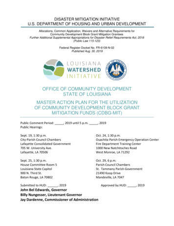
DISASTER MITIGATION INITIATIVEU.S. DEPARTMENT OF HOUSING AND URBAN DEVELOPMENTAllocations, Common Application, Waivers and Alternative Requirements forCommunity Development Block Grant Mitigation GranteesFurther Additional Supplemental Appropriations for Disaster Relief Requirements Act, 2018(Public Law 115-123)Federal Register Docket No. FR-6109-N-02Published Aug. 30, 2019OFFICE OF COMMUNITY DEVELOPMENTSTATE OF LOUISIANAMASTER ACTION PLAN FOR THE UTILIZATIONOF COMMUNITY DEVELOPMENT BLOCK GRANTMITIGATION FUNDS (CDBG-MIT)Public Comment Period: , 2019 until 5 p.m. , 2019Public Hearings:Sept. 19, 1:30 p.m.City-Parish Council ChambersLafayette Consolidated Government705 W. University Ave.Lafayette, LA 70506Oct. 24, 1:30 p.m.Ouachita Parish Emergency Operation CenterFire Department Training Center1000 New Natchitoches RoadWest Monroe, LA 71292Sept. 25, 1:30 p.m.House Committee Room 5Louisiana State Capitol900 N. Third St.Baton Rouge, LA 70802Oct. 29, 6 p.m.Parish Council ChambersSt. Tammany Parish Government21490 Koop DriveMandeville, LA 7047Submitted to HUD: , 2019John Bel Edwards, GovernorBilly Nungesser, Lieutenant GovernorJay Dardenne, Commissioner of AdministrationApproved by HUD: , 2019
TABLE OF CONTENTSI.Critical Definitions . 7II. Executive Summary . 10III. Authority and Purpose . 13IV. Fund Distribution . 14IV. A. HUD-Identified MID Areas or HUD MIDs. 14IV. B. State-Identified MID Areas or LA MIDs . 14V. Mitigation Needs Assessment . 17V. A. Outline . 17V. B. Louisiana’s Landscape . 18V. C. Historic Damage Pattern . 19V. D. State and Local Hazard Mitigation Plans, Research and Analysis . 20Cost of Future Risks. 20Future Risk to Vulnerable Jurisdictions . 21Local Hazard Mitigation Plans or HMPs . 22Existing Efforts, Studies and Plans . 24V. E. Greatest Risk: Wind and Flood Hazards . 27Tropical Cyclones . 28Floods . 30Sea Level Rise . 31Extreme Precipitation . 32V. F. Critical Service Areas or Community Lifelines . 33Critical Service Area No. 1: Safety and Security . 35Critical Service Area No. 2: Communications. 35Critical Service Area No. 3: Food, Water and Sheltering . 36Critical Service Area No. 4: Transportation . 37Critical Service Area No. 5: Health and Medical . 38Critical Service Area No. 6: Hazardous Material (Management) . 39Critical Service Area No. 7: Energy (Power and Fuel) . 40V. G. Ecosystem Integrity and Watershed Resilience . 40V. H. Unmet Mitigation Needs . 41Unmet Mitigation Need: Flood-Resilient Development Patterns. 41Unmet Mitigation Need: Watershed Data and Modeling . 42Unmet Mitigation Need: Cross-Jurisdictional Coordination . 42WORKING TOGETHER FOR SUSTAINABILITY AND RESILIENCEPage 2
Unmet Mitigation Need: Flood Control Projects . 43VI. Risk Distribution among LMI or Otherwise Vulnerable Communities . 43VII. Approaches to Address Mitigation Needs . 47VII. A. Connection between Mitigation Needs and Allocation of Funds . 47VII. B. Allocation of Funds . 47VII. C. The Louisiana Watershed Initiative . 48The Council on Watershed Management (Council) . 49Regional Steering Committees and Coalitions . 49Timeline. 50VII. D. LWI Program Areas. 51Program Area No. 1: Watershed (Local and Regional) Projects and Programs . 52Program Area No. 2: State Projects and Programs . 54Program Area No. 3: Watershed Monitoring, Mapping and Modeling . 58Program Area No. 4: Watershed Policy, Planning and Local Capacity Assistance . 60VII. E. Administrative Costs . 63VII. F. Non-Federal Cost Share Assistance . 64VII. G. Leveraging Funds . 65VIII. Coordination and Alignment . 67IX. Citizen Participation . 70IX. A. Citizen Input. 70IX. B. Required Consultations . 70IX. C. LWI Public Engagement . 71IX. D. Citizen Complaints . 74IX. E. Receipt of Comments . 74Public Hearing No. 1: Lafayette. 74Public Hearing No. 2: East Baton Rouge . 75Public Hearing No. 3: Ouachita . 75Public Hearing No. 4: St. Tammany. 75IX. F. Amendments to the Action Plan . 75X. Additional Requirements and Considerations . 76X. A. Certification of Controls, Processes and Procedures . 76X. B. Implementation Plan and Capacity Assessment . 76X. C. Projection of Expenditures and Outcomes . 76X. D. Program Income . 76X. E. Plans to Minimize Displacement and Ensure Accessibility . 77X. F. Protection of People and Property and Construction Methods . 77WORKING TOGETHER FOR SUSTAINABILITY AND RESILIENCEPage 3
X. G. Natural or Green Infrastructure Standards . 77X. H. Green Building Standards . 78X. I. Operation and Maintenance Plans . 78X. J. Cost Verification Procedures . 79Appendix A: Additional Definitions . 79Appendix B: Common Acronyms . 84Appendix C: Citizen Participation Plan . 85Appendix D: Projection of Expenditures and Outcomes (“Spending Plan”) . 89Appendix E: LWI Provisional Watershed Boundaries . 91WORKING TOGETHER FOR SUSTAINABILITY AND RESILIENCEPage 4
LIST OF FIGURESFigure 1. HUD-Identified MIDs or HUD MIDsFigure 2. MIDs Impacted by 2016 FloodsFigure 3. DR-4263 Declarations OverviewFigure 4. DR-4277 Declarations OverviewFigure 5. State-Claimed Water BodiesFigure 6. Elevation and HydrographyFigure 7. Special Flood Hazard Areas (SFHAs)Figure 8. Number of Disaster Declarations 1999-2019Figure 9. NFIP Average Claim PaymentsFigure 10. Disaster Declarations since 2015 SHMP UpdateFigure 11. Tropical Cyclone Tracks across Louisiana 1900-2017Figure 12. Losses Associated with 1% AEP Flood by Census BlockFigure 13. 2067 Coastal Land Loss Projections (No Action)Figure 14. Louisiana Average Annual Rainfall DistributionFigure 15. Natural Hazards and Estimated SeverityFigure 16. Technological Hazards and Estimated SeverityFigure 17. Projected Flooded Roads under Coastal 1% AEP ScenarioFigure 18. 50-Year Projected Flood Risk to Hospitals in the Coastal AreaFigure 19. Social Vulnerability and Hazard ExposureFigure 20. LWI Provisional Watershed RegionsFigure 21. LWI TimelineFigure 22. Louisiana Watershed Initiative CDBG-MIT Expenditure TimelineWORKING TOGETHER FOR SUSTAINABILITY AND RESILIENCEPage 5
LIST OF TABLESTable 1. CDBG-MIT Program BudgetTable 2. SHMP 2043 Projected Annual Losses as a Result of Natural Hazard ImpactsTable 3. SHMP 2043 Projected Vulnerable JurisdictionsTable 4. SHMPC Identification of Hazards within HUD MID HMPsTable 5. SHMPC Identification of Hazards within LA MID HMPsTable 6. SHMPC Identification of Hazards outside HUD and LA MID HMPsTable 7. Estimated Change in Vulnerability to Future HazardsTable 8. HUD MID Vulnerable Populations Average Annual Growth RatesTable 9. LA MID Vulnerable Populations Average Annual Growth RatesTable 10. CDBG-MIT Program BudgetTable 11. Watershed (Local and Regional) Projects and Programs Funding RoundsWORKING TOGETHER FOR SUSTAINABILITY AND RESILIENCEPage 6
I. CRITICAL DEFINITIONSAction Plan or AP: After HUD publishes the Federal Register Notice for a congressional appropriation,the grantee (eligible government) must develop and submit an Action Plan describing the needs,strategies and projected uses of the CDBG‐MIT funds. HUD must approve the Action Plan before fundsare available.CDBG‐MIT: Community Development Block Grant‐Mitigation assistance is the term for the HUD fundingstream that is allocated to eligible disaster recovery entities via congressional appropriations. HUDprovides flexible CDBG‐MIT grants to cities, counties and states to assist areas impacted by recentdisasters. Grantees are empowered to carry out strategic and high-impact activities to mitigate disasterrisks and reduce future losses, while at the same time transform State and local planning1.Covered Project: As per FR-6109-N-02, includes infrastructure projects having a total project cost of 100 million or more, with at least 50 million of CDBG funds (regardless of source (CDBG–DR, CDBG–NDR, CDBG–MIT, or CDBG)).Federal Register or FR: The Federal Register is the official journal of the federal government of theUnited States that contains government agency rules, proposed rules and public notices. It is publisheddaily, except on federal holidays. The final rules published in the Federal Register are ultimatelyreorganized by topic or subject matter and codified in the Code of Federal Regulations, which is updatedannually.Federal Register Notice or FRN: For each congressional appropriation, HUD publishes a Federal RegisterNotice that outlines the rules and regulations for the CDBG‐MIT funding.FEMA: The Federal Emergency Management Agency is an agency of the United States Department ofHomeland Security, initially created by Presidential Reorganization Plan No. 3 of 1978 and implementedby two Executive Orders on April 1, 1979. The agency's primary purpose is to coordinate the response toa disaster that has occurred in the United States and that overwhelms the resources of local and stateauthorities. The governor of the state where the disaster occurs must declare a state of emergency andformally request from the president that FEMA and the federal government respond to the disaster.FEMA IA: Federal Emergency Management Agency Individual Assistance programs provide financial ordirect assistance to support the recovery of disaster survivors who have uninsured or underinsurednecessary expenses and serious needs. This may include assistance for temporary housing and housingrepairs, critical disaster related expenses, and the replacement of essential personal property. Thisassistance is not intended to restore your damaged property to its pre‐disaster condition. Through its IAprograms, FEMA may also provide funding to the state or tribal government to support programs thataddress crisis counseling, disaster case management, disaster legal services and disaster unemploymentassistance.FEMA PA: The President can make Federal Emergency Management Agency Public Assistance availableto local, state and tribal governments, and certain types of private nonprofit organizations to removedebris, provide emergency protective measures, and restore equipment, buildings and otherinfrastructure damaged by the disaster. This is done on a cost‐sharing basis.FEMA HMGP: The FEMA Hazard Mitigation Grant Program helps communities implement hazard1FR-6109-N-02. p3.WORKING TOGETHER FOR SUSTAINABILITY AND RESILIENCEPage 7
mitigation measures following a Presidential Major Disaster Declaration in the areas of the state, tribe,or territory requested by the Governor or Tribal Executive. The key purpose of this grant program is toenact mitigation measures that reduce the risk of loss of life and property from future disasters. HMGPis authorized under Section 404 of the Robert T. Stafford Disaster Relief and Emergency Assistance Act.Floodplain: Any area of land within a watershed that is susceptible to inundation by floodwaters fromany source.Floodplain Management: A decision-making process that aims to achieve the wise use of the nation'sfloodplains. It encompasses the choices made by owners of homes and businesses in the floodplain,decisions made by officials at all levels of government, plans made by land developers and contractors,and the judgment of the general public regarding future decisions to be made with regard to land use.Louisiana Watershed Initiative or LWI: Gov. John Bel Edwards established the Council on WatershedManagement, which serves as the coordinated, interagency structure at the state level for watershedbased flood risk reduction. In August 2018, the Council launched the LWI to serve as the programmaticarm under which all related efforts operate.Major Disaster Declaration: The President can declare a Major Disaster Declaration for any naturalevent, including any hurricane, tornado, storm, high water, wind‐driven water, tidal wave, tsunami,earthquake, volcanic eruption, landslide, mudslide, snowstorm, or drought, or, regardless of cause, fire,flood, or explosion, that the President believes has caused damage of such severity that it is beyond thecombined capabilities of state and local governments to respond. A major disaster declaration providesa wide range of federal assistance programs for individuals and public infrastructure, including funds forboth emergency and permanent work. Louisiana’s major disaster declarations for the March and Augustflooding events are as follows:o Severe Flooding (Disaster 4277) declared on August 14, 2016o Severe Flooding (Disaster 4263) declared on March 13, 2016Mitigation activities: Those activities that increase resilience to disasters and reduce or eliminate thelong-term risk of loss of life, injury, damage to and loss of property, and suffering and hardship, bylessening the impact of future disasters.Multi-hazard risk assessment: A hazard identification and risk assessment provides the factual basis foractivities proposed in the strategy portion of a hazard mitigation plan. An effective risk assessmentinforms proposed actions by focusing attention and resources on the greatest risks. The four basiccomponents of a risk assessment are (1) hazard identification, (2) profiling of hazard events, (3)inventory of assets and (4) estimation of potential human and economic losses based on the exposureand vulnerability of people, buildings and infrastructure.2Precipitation: Precipitation is water released from clouds in the form of rain, freezing rain, sleet, snowor hail. Most precipitation falls as rain and is the primary aspect of the water cycle that deliversatmospheric water to the Earth. For example, water vapor evaporates from oceans, lakes, forests, fields,animals and plants then condenses and returns to Earth as precipitation, thus replenishing reservoirs,lakes, rivers, underground aquifers and other sources of water that provide moisture needed by plantsand animals.3United States Federal Emergency Management Agency. Hazard Identification and Risk Assessment. 2019. Accessed onSeptember 5, 2019. k-assessment.3United States Geological Survey. Rain: A Water Resource, USGS General Interest Publication. 2019. Accessed on August 11,2019. NG TOGETHER FOR SUSTAINABILITY AND RESILIENCEPage 8
Provisional watershed regions: The LWI has established provisional watershed regions throughout thestate. These regions aggregate HUC8-level watersheds into eight watershed regions for LWImanagement purposes. See Figure 20 and Attachment G for more detail.U.S. Department of Housing and Urban Development or HUD: The US Department of Housing andUrban Development was established in 1965 by the Department of Housing and Urban DevelopmentAct. HUD is the principal federal agency responsible for programs concerned with the nation's housingneeds, fair housing opportunities, and improvement and development of the nation’s communities.HUD provides the main source of funding for Louisiana’s recovery from hurricanes Katrina, Rita, Gustav,Ike and Isaac; and the March and August flooding events. HUD is the agency that administers theCommunity Development Block Grant-Disaster Mitigation, or CDBG-MIT, funds available to Louisianafrom a congressional appropriation. HUD’s allocation of this appropriation provides funding for thissolicitation and program.Watershed: A watershed is a geographic area within the boundary of a drainage divide. The USGSdefines a watershed as follows: “A watershed is an area of land that drains all the streams and rainfall toa common outlet such as the outflow of a reservoir, mouth of a bay, or any point along a streamchannel. The word ‘watershed’ is sometimes used interchangeably with ‘drainage basin’ or ‘catchment.’It is a land feature that can be identified by tracing a line along the highest elevations between twoareas on a map, often a ridge. Large watersheds, like the Mississippi River basin contain thousands ofsmaller watersheds.4Additional definitions and common acronyms relevant to this AP are detailed in Appendices A and B.USGS. Water Science Glossary of Terms. 2019. Accessed on September 18, 2019. hool/science/dictionary-water-terms?qt-science center objects 0#qt-science center objects.4WORKING TOGETHER FOR SUSTAINABILITY AND RESILIENCEPage 9
II. EXECUTIVE SUMMARYBeginning with Hurricane Katrina’s landfall in August 2005, each of Louisiana’s 64 parishes has beenincluded in a federal major disaster declaration as a result of a named tropical event. Moreover, theGreat Floods of 2016 – two rainfall events six months apart and affecting wide swaths of the state,caused severe flash and riverine floods and led to major disaster declarations in 56 parishes. Theseevents have left an indelible mark on Louisiana and have exposed new challenges within the state’sapproach to flood risk reduction.Since Hurricanes Katrina and Rita the state has adopted stricter building codes, safer flood levels, andformed of the Coastal Protection and Restoration Authority (CPRA), which relies on science andengineering to produce and regularly update the Coastal Master Plan. After Hurricane Isaac, with fundsprovided by HUD’s National Disaster Resilience Competition, Louisiana created the Strategic Adaptationsfor Future Environments Program (LA SAFE) to create a model for engaging citizens in the planning ofthe long-term resilience of their communities.The Great Floods of 2016 exposed another risk the State faces: how to better manage riverine and flashflooding as a result of extreme precipitation events. The state identified regional watershed-based floodrisk management as a means to systematically address water management and avoid interventions thatmay unintentionally increase runoff or subsequent flooding on adjacent communities, upstream anddownstream.Soon after the state began its investigation of this new approach, per the Bipartisan Budget Act of 2018,Congress allocated 1,213,917,000 CDBG-MIT funds to the State of Louisiana for the specific purpose ofmitigation activities as specified in Public Law 115-123 and FR-6109-N-02. The rules for expenditure ofthese funds require the submittal of an Action Plan or AP for approval by HUD. This Action Plan or APprovides a concise summary of the actions, activities, and resources necessary to address the State ofLouisiana’s priority mitigation needs and goals.As the next step in Louisiana’s response to its increasingly complex flood risk profile, the statecompleted its investigation of watershed management and Governor John Bel Edwards charged stateagencies with coordinating statewide floodplain management efforts through a watershed-basedapproach, referred to as the Louisiana Watershed Initiative or LWI.Building on the efforts and methodologies of both the Coastal Master Plan and LA SAFE, the LWI takes astatewide approach to watershed-based floodplain management to reduce flood risk vulnerabilitiesthrough pre-disaster mapping, modeling, and watershed management planning – backed by large-scaleinvestments in projects and programs that directly mitigate risks.The LWI combines the Coastal Master Plan’s focus on data, science and engineering with the communityengagement lessons learned through LA SAFE to work across all sectors of government and the statecommits to working in partnership with local communities statewide toward an integrated, watershedbased approach to floodplain management that combines physical, biological, ecological,socioeconomic, and policy-based solutions emanating from a comprehensive scientific understanding ofthe state’s hydrologic processes.In administering this grant, the state and its various jurisdictions and political subdivisions willWORKING TOGETHER FOR SUSTAINABILITY AND RESILIENCEPage 10
coordinate expenditures and activities through the LWI to improve statewide floodplain managementwithin watershed regions.With regards to CDBG-MIT fund distribution, Public Law 115-123 limits fund expenditure to the mostimpacted and distressed or MID areas associated with the Great Floods of 2016. HUD has identified tensuch areas and the state of Louisiana has identified 46 more. At least 50%, or 606,958,500 of the CDBGMIT funds will be expended in or benefit HUD-identified MIDs or HUD MIDs. The remaining CDBG-MITfunds will be expended in or benefit LA-identified MID areas or LA MIDs, discussed in more detail inSection IV.In accordance with the requirements of the federal register notice or FRN (FR-6109-N-02), the stateconducted a mitigation needs assessment detailed in Section V to inform projects and programs with afocus on addressing risks to indispensable services, identifying and analyzing all significant current andfuture disaster risks, and providing a substantive basis for the activities described within this AP. TheAssessment relies on stakeholder consultations, data, research, previous regional planning efforts, theState Hazard Mitigation Plan, the state Emergency Operations Plan, and available local hazard mitigationplans to inform, identify and prioritize urgent unmet mitigation needs.Based on this assessment, the state finds that—whether by flash flooding, inland rivers, stormwater, orcoastal storm surge—Louisiana is facing increased risk, in both magnitude and frequency, of floodevents. This risk threatens our natural and built environment, and our way of life.5 Specifically: Both HUD and LA MID areas share a collective risk profile that includes wind and flood hazards,which are compounded by the effects of subsidence and sea level rise. These trends are largelyconsistent within local HMPs outside of HUD and LA MIDs, demonstrating that overall disasterrisks correlate statewide and consistently reinforce that flooding remains a difficult to predictstate-wide risk. This difficulty is compounded when attempting to assemble future projections of risks because thestate does not have the ability to accurately estimate the cost of long-term and repeated flooddamage. As a result, future wind- and flood-related damages are largely underestimated. These risks will continue to escalate in a warming world, where the frequency and intensity oftropical cyclones and severe thunderstorms are anticipated to increase. Both state and local hazard plans consistently demonstrate that the entire State of Louisiana is atsevere flood risk, and that the occurrence of future catastrophic flood events cannot be predictedsolely by relying on the damage patterns of past events. To this effect, this AP and efforts associated with the LWI propose a proactive pre-disasterapproach that accommodates—to a reasonable extent given the requirements of FRN-6109-N02—the probability of future events occurring in any location i
Lafayette, LA 70506 Sept. 25, 1:30 p.m. House Committee Room 5 Louisiana State Capitol 900 N. Third St. Baton Rouge, LA 70802 Oct. 24, 1:30 p.m. Ouachita Parish Emergency Operation Center Fire Department Training Center 1000 New Natchitoches Road West Monroe, LA 71292 Oct. 29, 6 p.m. Parish Council Chambers St. Tammany Parish Government





![Office 2010 Professional Plus Com Ativador Serial Keyl [EXCLUSIVE]](/img/61/office-2010-professional-plus-com-ativador-serial-keyl-exclusive.jpg)
