Transcription
AECOM5555 Glenwood Hills Pkwy, Ste. 300Grand Rapids, MI 49512616-942-9600616-940-4396telfaxAugust 22, 2014Federal Consistency CoordinatorIllinois Coastal Management ProgramIllinois Department of Natural Resources160 N. LaSalle, Ste. 700Chicago, Illinois 60601Subject: Federal Notice of Consistency Determination, U.S. Coast Guard Station WilmetteHarbor, Proposed Dredging of Boat BasinDear Federal Consistency Coordinator:On behalf of the United States Coast Guard (USCG), AECOM Technical Services, Inc. (AECOM) issubmitting this notice of Federal Consistency with the Coastal Zone Management Act (CZMA), 16USC 1456, applicable regulations (15 Code of Federal Regulations 930) and the Illinois CoastalManagement Program (ICMP) for proposed dredging of the harbor and bulkhead rehabilitation atthe USCG Station Wilmette Harbor in Wilmette, Illinois. The ICMP and USCG guidelines (Tools forDecision-Making: Environmental Considerations, USCG Office of Civil Engineering) specify that theUSCG determines if a USCG project is consistent with enforceable provisions of the ICMP.The proposed project is in the Illinois Coastal Zone, will have no coastal effects to natural or culturalresources, and requires federal permits and state 401 Water Quality Certification. The proposedproject is a federal activity identified in the ICMP as being in the national interest. The projectinvolves improvements to water transportation, ports and navigation facilities. The USCG is part ofthe Department of Homeland Security, so the project is in the national interest because it willsupport the USCG’s coastal security mission.This letter provides supporting information for this Notice of Consistency, including: Project location and location map; Purpose of the project; Start date and duration of the project; Description of the project; Project review related to environmental and cultural resources; and Contact information.60303281 STA Wilmette Harbor CZM Consistency Notice.docx
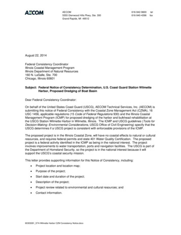
AECOM2LocationStation Wilmette Harbor is located at 10 Harbor Drive in the southeast corner of Gillson Park at theorigin of the North Shore Channel in Section 35, Township 42 North, Range 13 East within theVillage of Wilmette, Cook County, Illinois. Attachment A shows the project location. AttachmentB is an aerial photograph of the general area. The harbor is continuous with Lake Michigan, but isseparated from the North Shore Channel by the Wilmette Pumping Station, which normally pumpswater from Lake Michigan to the North Shore Channel.Station Wilmette Harbor consists of an onshore two-story brick multi-purpose building, 10,973square feet in size, with duty rooms and attached boat storage building. The project site includes alawn shed, waste oil shed, aboveground fuel pads, communications tower, access roads andparking areas, a launchway for USCG vessels, boat basin, four permanent docks, and floatingdocks. The boat basin is located in Wilmette Harbor with concrete-capped bulkheads supported bytimber cribs line the shore. The bulkheads and the launchway are in poor condition. Adjacent andto the east of the station is the Marshall Mansion, which houses the Sheridan Shores Yacht Club.Figure 2 is an aerial photograph of the Station. Photographs of Station Wilmette Harbor can befound in Attachment C.PurposeUSCG Station Wilmette Harbor’s primary responsibility is Search and Rescue. The Stationcompletes approximately 90 to 100 Search and Rescue cases each year. The Station’s otherresponsibilities include maritime law enforcement, boating safety and security for special marineevents and Presidential security zones. The Station’s area of responsibility covers Lake Michiganfrom Great Lakes, IL to downtown Chicago, including half-way across the Lake.The purpose of the proposed project is to rehabilitate or replace the deteriorated bulkheads anddredge the boat basin to a required depth below the International Great Lakes Datum (IGLD) atUSCG Station Wilmette Harbor in order for the Unit to transit, moor and be able to execute theiroperational missions without the encumbrances of shoaling or reduced lake levels they currently areexperiencing.Project Start Date and DurationThe project will start in 2015; the exact start date has not been determined. The work will be donein the fall, winter or spring to minimize impact on recreational boating in the harbor. The site workwill be completed in two phases: the first phase involves the dredging and bulkeahd work, and isexpected to be completed in approximately four months; and the second phase involves thelaunchway work and is expected to be completed in approximately three months. This projectrequires a Section 404 Clean Water Act permit and a Section 401 Water Quality Certification beforework can begin.Description of the ProjectThe project includes: Dredging the USCG boat basin to 8 feet below LWD with a one foot over dredge. LWD forLake Michigan is elevation 577.5 IGLD85. Therefore, dredging is to proceed to elevation568.5. Approximately 1,200 cubic yards of sediment will be dredged from the USCG boatbasin and Wilmette Harbor.K:\Projects\60303281 Various D9 Unit Dredging\500-DELIVERABLES\510-STA Wilmette Harbor\510.6 CZM\60303281 STA Wilmette HarborCZM Consistency Notice.docx
AECOM3 Remove approximately 140 feet of concrete main bulkhead and paving adjacent to theStation and replace it with steel sheet pile. Rehabilitation of existing steel sheet piling launchway bulkhead with replacement of certaintimber members and remove upper portion of the existing steel sheet piling and timbersoldier piles, along with the existing timber cap, waler and fender near the top of the walland replace with steel sheet pile. Remove existing launchway timber decking, framing members and decayed upper portionof each timber support pile and construct a reinforced concrete slab-on-grade oncompacted, granular fill.Drawings of the area and depth of the proposed dredging are in Attachment D.Dredging will be done using equipment operated from shore or from a barge. The dredged materialwill be transported by truck if dredging is done from shore or by both barge and truck if dredging isdone from a barge. Dredged material will be disposed of at Waste Management’s CountrysideLandfill (Lake County). Demolition debris from the bulkhead rehabilitation will also be disposed of atCountryside Landfill. Some components of the bulkheads have lead-based paint (defined by theUS EPA as a lead concentration of 5,000 parts per million or more). The components with leadbased paint will be removed and disposed properly and Countryside Landfill or recycling facility, ifacceptable.Project ReviewPhysical Environment: Physical changes to the environment are limited to deepening of the harbor,rehabilitation of the existing shoreline and launchway bulkheads and rehabilitation of the launchway.Coastal Erosion and Flooding: The dredging project will not affect coastal erosion or flooding.Rehabilitation of the bulkheads may prevent future erosion, but will not affect flooding.Natural Environment: The project will not affect the terrestrial environment because material will bedisposed of at an existing licensed landfill (or appropriate facility for components with lead-basedpaint). The Station Wilmette Harbor has been previously dredged, so natural plant communities willnot be affected. The Station itself is an entirely developed area that is already paved or supportsstructures, and vegetation is limited to frequently mowed grass or conventional landscaping.On behalf of the USCG, AECOM reviewed the U.S. Fish and Wildlife Service (USFWS) Section 7technical assistance website (http://www.fws.gov/Midwest/endangered/section 7/index.html) forfederally listed threatened and endangered species. The following nine species are listed aspresent in Cook County: Northern long-eared bat (Myotis septentrionalis); Eastern massasauga(Sistrurus catenatus); Piping plover (Charadrius melodus); Hine’s emerald dragonfly (Somatochlorahineana); Rattlesnake-master borer moth (Papaipema eryngli); Eastern prairie fringed orchid(Platanthera leucophaea); Leafy-prairie clover (Dalea foliosa); Mead’s milkweed (Asclepias meadii);and Prairie-bush clover (Lespedeza leptostachya).The Wilmette Harbor Station and surrounding areas were inspected by an environmental scientistfrom AECOM on November 18, 2013. At that time, no habitat was found for any of the species listedabove at the Station. Potential habitat for piping plover was present near the Station at the sandybeach habitat along the shoreline of Lake Michigan. The site inspection did not identify any pipingplovers. On the north side of the North Channel habitat was present, however this portion of theK:\Projects\60303281 Various D9 Unit Dredging\500-DELIVERABLES\510-STA Wilmette Harbor\510.6 CZM\60303281 STA Wilmette HarborCZM Consistency Notice.docx
AECOM4beach is used as a dog beach by the community and it is unlikely that any piping plovers would befound on the north side.The USCG determined that the proposed dredging project may affect but is unlikely to adverselyaffect the piping plover. This determination was made on the basis that barges may be used forstaging for the dredging operations and for transfer of the sediments to the final disposal site. Ifbarge traffic occurs near the beach located on the shore of Lake Michigan south of the NorthChannel, the potential for the noise associated with this barge traffic could result in piping ploversavoiding the beach.The USCG requested concurrence with its effect determinations from USFWS on December 6,2013. The USFWS stated in a December 20, 2013 telephone conversation, that the USCG wouldbe justified in making a no-effect determination for the piping plover. Attachment E providesdocumentation of consultation with USFWS. The USCG subsequently made a no-effectdetermination regarding federally listed threatened and endangered species; this determination isalso in Attachment E.Environmental Contamination: The sediments to be dredged will be sampled and analyzed, andthis information will be included in the permit applications. The dredged material will be managedand disposed of as required by applicable regulations and no impacts are expected. Somecomponents of the bulkheads have lead-based paint. These components will be managedappropriately and disposed of at an appropriate facility.Cultural Resources: The proposed dredging activities will be conducted in a manner such that therewill be no disturbance to recorded archaeological sites and historic standing structures.Subsurface, terrestrial archaeological deposits, if present, will be avoided by staging from theexisting parking lot, boat launch, and mooring pier or from a barge. Therefore, the USCG hasdetermined “No Historic Properties Affected.” We are providing separate documentation regardingcompliance with Section 106 of the National Historic Preservation Act to Ms. Anne Haaker, DeputyState Historic Preservation Officer, Illinois Historic Preservation Agency.Contact InformationThe USCG contact for this project is:Charlie MaricicUS Coast Guard1240 East Ninth StreetCleveland, OH 44199-2060(216) 902-6304ConclusionOn behalf of the USCG, AECOM reviewed the potential impacts of dredging the boat basin atStation Wilmette Harbor and rehabilitation of the main bulkhead and launchway. AECOMconcluded that the proposed activity is consistent the ICMP and will be conducted in a mannerconsistent with such ICMP’s policies. We request your written concurrence with this determination.We understand your concurrence will be conditional on the project obtaining and complying with therequired permits. We would appreciate receipt of your written concurrence within approximatelyfour weeks of your receipt of this letter; this will help us maintain the overall schedule for thisproject.K:\Projects\60303281 Various D9 Unit Dredging\500-DELIVERABLES\510-STA Wilmette Harbor\510.6 CZM\60303281 STA Wilmette HarborCZM Consistency Notice.docx
AECOM5Thank you for your consideration. If you need additional information or have questions, pleasecontact Glenn Hendrix at (616) 940-4406 (glenn.hendrix@aecom.com) or Cheryl Nash at (312) 3736808 (Cheryl.Nash@aecom.com).Sincerely,Glenn HendrixSenior ScientistCheryl NashSenior Project ScientistAttachment A – Dredge Site Location MapAttachment B – Dredge Site Aerial PhotographsAttachment C – Dredge Site Ground Level PhotographsAttachment D – 35% Design PlansAttachment E – USFWS DocumentationCc:Michelle L. Freimund, AECOM Technical Services, Inc.Charles Maricic, USCG Civil Engineering Unit ClevelandK:\Projects\60303281 Various D9 Unit Dredging\500-DELIVERABLES\510-STA Wilmette Harbor\510.6 CZM\60303281 STA Wilmette HarborCZM Consistency Notice.docx
ATTACHMENT (A)DREDGE SITE - LOCATION MAPK:\Projects\60303281 Various D9 Unit Dredging\500-DELIVERABLES\510-STA Wilmette Harbor\510.6 CZM\60303281 STA Wilmette HarborCZM Consistency Notice.docx
Last saved by: MUELLERLEILEK(2013-09-27)Filename: J:\Projects and Proposal\US Coast Guard\60303281 Dredging at Various D9 Units IL-MI-WI\900 WorkingDocs-CAD\GIS\Wilmette.mxdSite LocationSite Location0Source: Evanston 7.5 Minute USGS Quadrangle Topographic MapUS Coast Guard10 Harbor DriveWilmette, IllinoisProject No.: 60303281Date: 9/27/2013Site Location MapStation Wilmette HarborCook County1,0002,0004,000FeetFigure 1
AECOM7ATTACHMENT (B)DREDGE SITE – AERIAL PHOTOGRAPHK:\Projects\60303281 Various D9 Unit Dredging\500-DELIVERABLES\510-STA Wilmette Harbor\510.6 CZM\60303281 STA Wilmette HarborCZM Consistency Notice.docx
US Coast GuardStation Wilmette HarborCook County, IllinoisDredge Site –Aerial PhotographAttachment BNovember 2013
AECOM8ATTACHMENT (C)DREDGE SITE – GROUND-LEVEL PHOTOGRAPHSK:\Projects\60303281 Various D9 Unit Dredging\500-DELIVERABLES\510-STA Wilmette Harbor\510.6 CZM\60303281 STA Wilmette HarborCZM Consistency Notice.docx
ATTACHMENT CDREDGE SITE – Ground Level PhotographsClient Name:Site Location:Project No.USCGUSCG Station Wilmette Harbor2270838Photo No.1Date:11/18/13Description:Rear of Main multipurpose buildingbuilding built 1931Looking NorthPhoto No.2Date:11/18/13Description:Rear of USCG multiuse building, taken fromUSCG pier. Twogarages with bottomramp to Harbor.building built 1931Looking North East
ATTACHMENT CDREDGE SITE – Ground Level PhotographsClient Name:Site Location:Project No.USCGUSCG Station Wilmette Harbor2270838Photo No.Date:11/18/133Description:Rear of USCG multiuse buildingbuilding built 1931Looking NorthPhoto No.4Date:11/18/13Description:Full view of front ofUSCG multi-usebuilding built 1931Looking South
ATTACHMENT CDREDGE SITE – Ground Level PhotographsClient Name:Site Location:Project No.USCGUSCG Station Wilmette Harbor2270838Photo No.5Date:11/18/13Description:Rear of USCG withMoorings and BoatRampsLooking North EastPhoto No.6Date:11/18/13Description:Lawn, dry dock of oneof USCG boats andboat ramp to muftipurpose buildingLooking Northwest
ATTACHMENT CDREDGE SITE – Ground Level PhotographsClient Name:Site Location:Project No.USCGUSCG Station Wilmette Harbor2270838Photo No.7Date:11/18/13Description:USCG Fueling padLooking NortheastPhoto No.8Date:11/18/13Description:Moorings and floatingdockLooking Northwest
ATTACHMENT CDREDGE SITE – Ground Level PhotographsClient Name:Site Location:Project No.USCGUSCG Station Wilmette Harbor2270838Photo No.9Date:11/18/13Description:Moorings taken fromUSCG pierLooking EastPhoto No.10Date:11/18/13Description:Moorings and overviewof HarborLooking West
ATTACHMENT CDREDGE SITE – Ground Level PhotographsClient Name:Site Location:Project No.USCGUSCG Station Wilmette Harbor2270838Photo No.11Date:11/18/13Description:View of Harbor fromadjacent beachshowing complete widthof inlet to the Harbor forbargesLooking WestPhoto No.12Date:11/18/13Description:Front of small buildingon USCG groundsbuilt 1980Looking East
ATTACHMENT CDREDGE SITE – Ground Level PhotographsClient Name:Site Location:Project No.USCGUSCG Station Wilmette Harbor2270838Photo No.13Date:11/18/13Description:Rear of small buildingon USCG grounds,built 1980Looking South WestPhoto No.14Date:11/18/13Description:Shed and electricalpower boxes on USCGpropertyLooking Southwest
ATTACHMENT CDREDGE SITE – Ground Level PhotographsClient Name:Site Location:Project No.USCGUSCG Station Wilmette Harbor2270838Photo No.15Date:11/18/13Description:Close-up ofcommunication towerand small building onUSCG groundsLooking North WestPhoto No.16Date:11/18/13Description:Viewpoint of Harborand Sheridan ShoresYacht Club taken fromadjacent beach.Looking West
ATTACHMENT CDREDGE SITE – Ground Level PhotographsClient Name:Site Location:Project No.USCGUSCG Station Wilmette Harbor2270838Photo No.17Date:11/18/13Description:View of adjacentPropertyWaterside of SheridanShores Yacht Club,built 192920 Harbor DriveWilmette, IlLooking NorthwestPhoto No.18Date:11/18/13Description:Side view of SheridanShores Yacht Clubbuilt 192920 Harbor DriveWilmette, IlLooking East
ATTACHMENT CDREDGE SITE – Ground Level PhotographsClient Name:Site Location:Project No.USCGUSCG Station Wilmette Harbor2270838Photo No.Date:11/18/1319Description:Landside view ofSheridan Shores YachtClubbuilt 192920 Harbor DriveWilmette IlLooking SouthPhoto No.20Date:11/18/13Description:Sheridan Shores YachtClub Shed boat fuelingstationAdjacent to USCG,sharing the sameharborLooking Northeast
AECOM9ATTACHMENT (D)35% DESIGN PLANSK:\Projects\60303281 Various D9 Unit Dredging\500-DELIVERABLES\510-STA Wilmette Harbor\510.6 CZM\60303281 STA Wilmette HarborCZM Consistency Notice.docx
1035 Kepler DriveGreen Bay, WI 54311
1035 Kepler DriveGreen Bay, WI 54311
1035 Kepler DriveGreen Bay, WI 54311
1035 Kepler DriveGreen Bay, WI 54311
1035 Kepler DriveGreen Bay, WI 543111CROSS SECTION THROUGH LAUNCHWAY RAMPC-09 SCALE:1/4" 1'-0"
1035 Kepler DriveGreen Bay, WI 54313
1035 Kepler DriveGreen Bay, WI 54313
1035 Kepler DriveGreen Bay, WI 54313
AECOM10ATTACHMENT (E)USFWS DOCUMENTATIONK:\Projects\60303281 Various D9 Unit Dredging\500-DELIVERABLES\510-STA Wilmette Harbor\510.6 CZM\60303281 STA Wilmette HarborCZM Consistency Notice.docx
\AECOM5555 Glenwood Hills Parkway, SEGrand Rapids, Michigan emorandumToU.S. Coast GuardCCMichelle Freimund, AECOMSubjectSection 7 Endangered Species Act Consultation – Dredging at USCG StationWilmette Harbor, Wilmette Illinois.FromGlenn Hendrix, Senior Scientist, AECOMDateAugust 18, 2014Page1The United States Coast Guard (USCG) is completing an Environmental Assessment (EA) fordredging, bulkhead rehabilitation and launchway rehabilitation at the USCG Station Wilmette Harbor,located at 10 Harbor Drive in the City of Wilmette, Lake County, Illinois. The Station is on the northside of the harbor and is bordered on three sides by Gillson Park. Station Wilmette Harbor is anentirely developed property that is already paved or supports structures, and vegetation is limited tofrequently mowed grass and conventional landscaping. Wilmette Harbor has been previouslydredged.USCG proposes to modify the Station’s existing boat basin by dredging to a depth of 9 feet below theLow Water Datum (LWD) for Lake Michigan. LWL for Lake Michigan is 577.5 feet, so the boat basinwill be dredged to 568.5 feet above sea level. This project is necessary due to lower lake levels, andthe additional depth is needed to accommodate the USGC vessels assigned to Station WilmetteHarbor. Dredged material will be staged either on paved areas at the Station or on a barge. Thedredged sediment will be disposed of at a licensed landfill.The bulkheads bordering the Station and the launchway at the Station will be rehabilitated or rebuilt atthe same locations as the existing facilities. Demolition material will be disposed of at a landfill.On behalf of the USCG, AECOM reviewed the U.S. Fish and Wildlife Service (USFWS) Section 7technical assistance website (http://www.fws.gov/Midwest/endangered/section 7/index.html) forfederally listed threatened and endangered species. The following nine species are listed as presentin Cook County: Northern long-eared bat (Myotis septentrionalis); Eastern massasauga (Sistruruscatenatus); Piping plover (Charadrius melodus); Hine’s emerald dragonfly (Somatochlora hineana);Rattlesnake-master borer moth (Papaipema eryngli); Eastern prairie fringed orchid (Platantheraleucophaea); Leafy-prairie clover (Dalea foliosa); Mead’s milkweed (Asclepias meadii); and Prairiebush clover (Lespedeza leptostachya). Table 1 summarizes the species listed in Cook County, thestatus of the species and habitat requirements.The Wilmette Harbor Station and surrounding areas were inspected by an environmental scientistfrom AECOM on November 18, 2013. At that time, no habitat was found for any of the species listedabove at the Station. Potential habitat for piping plover was present near the Station at the sandybeach habitat along the shoreline of Lake Michigan. The site inspection did not identify any pipingplovers. On the north side of the North Channel, plover habitat was present, however this portion ofthe beach is used as a dog beach by the community and it is unlikely that any piping plovers would befound on the north side.
Page 2AECOM determined that the proposed dredging project may affect but is unlikely to adversely effectthe piping plover. This determination was made on the basis that barges may be used for staging forthe dredging operations and for transfer of the sediments to the final disposal site. If barge trafficoccurs near the beach located on the shore of Lake Michigan south of the North Channel, thepotential for the noise associated with this barge traffic could result in piping plovers avoiding thebeach.AECOM requested concurrence with its effect determinations from USFWS on December 6, 2013.The USFWS stated in a December 20, 2013 telephone conversation, that the USCG would bejustified in making a no-effect determination for the piping plover.AECOM has concluded that the proposed project dredging, bulkhead rehabilitation and launchwayrehabilitation at the USCG Station Wilmette Harbor will have “no effect” on the listed species, theirhabitats, or designated critical habitats.If you have any questions regarding the Section 7 Endangered Species Act Consultation processcompleted for this project give Michelle Freimund at (920) 236-6712 or Glenn Hendrix at(616) 940-4406, respectively.
Page 3Table 1. Listing of Endangered Species at Wilmette HarborStatusSpeciesNorthern sedasEndangeredPiping plover(Charadrius melodus)FederalEndangeredHine’s emerald1dragonflySomatochlora rus catenatus)FederalCandidateRattlesnake-master1borer moth(Papaipema eryngii)FederalCandidateEastern prairie ened1Leafy-prairie cover(Parnassia parviflora)1Mead’s milkweed(Asclepias meadii)Prairie-bush clover(Lespedezaleptostachya)1HabitatCaves and Mines, swarming in surroundingwooded areas in autumn. Roosts andforages in upland forests and woods.Lakeshore beachesYesNoGraminoid dominated plant communities(fens, sedge meadows, peatlands, wetprairies, open woodlands, and shrublands)NoUndisturbed prairie and woodland openingsthat contain their only food plant, rattlesnakemasterModerate to high quality wetlands, sedgemeadow, marsh, and mesic to wet prairiePrairie remnants on thin soil over limestoneFederalThreatenedLate successional tallgrass prairie, tallgrassprairie converted to hay meadowFederalThreatenedNoSpring fed wetlands, wet meadows Dry to mesic prairies with gravelly soilNoSource: USFWS, Midwest Region’s Section 7 Technical Assistance on7/index.html (accessed November 2013).
Grand Rapids, MI 49512 60303281_STA Wilmette Harbor CZM Consistency Notice.docx August 22, 2014 . On behalf of the United States Coast Guard (USCG), AECOM Technical Services, Inc. (AECOM) is . The harbor is continuous with Lake Michigan, but is separated from the North Shore Channel by the Wilmette Pumping Station, which normally pumps .