Transcription
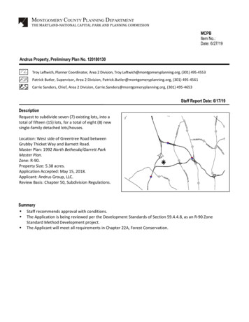
MONTGOMERY COUNTY PLANNING DEPARTMENTTHE MARYLAND-NATIONAL CAPITAL PARK AND PLANNING COMMISSIONMCPBItem No.:Date: 6/27/19Andrus Property, Preliminary Plan No. 120180130Troy Leftwich, Planner Coordinator, Area 2 Division, Troy.Leftwich@montgomeryplanning.org, (301) 495-4553Patrick Butler, Supervisor, Area 2 Division, Patrick.Butler@montgomeryplanning.org, (301) 495-4561Carrie Sanders, Chief, Area 2 Division, Carrie.Sanders@montgomeryplanning.org, (301) 495-4653Staff Report Date: 6/17/19DescriptionRequest to subdivide seven (7) existing lots, into atotal of fifteen (15) lots, for a total of eight (8) newsingle-family detached lots/houses.Location: West side of Greentree Road betweenGrubby Thicket Way and Barnett Road.Master Plan: 1992 North Bethesda/Garrett ParkMaster Plan.Zone: R-90.Property Size: 5.38 acres.Application Accepted: May 15, 2018.Applicant: Andrus Group, LLC.Review Basis: Chapter 50, Subdivision Regulations.Summary Staff recommends approval with conditions. The Application is being reviewed per the Development Standards of Section 59.4.4.8, as an R-90 ZoneStandard Method Development project. The Applicant will meet all requirements in Chapter 22A, Forest Conservation.
SECTION 1: RECOMMENDATION AND CONDITIONSPreliminary Plan No. 120180130Staff recommends approval of Preliminary Plan No. 120180130. All site development elements shownon the latest electronic version of Preliminary Plan No. 120180130 submitted via ePlans as of the date ofthis Staff Report are binding:Density1. This Preliminary Plan is limited to a total of 15 lots, for a total of eight (8) new single-familydetached houses, six (6) existing single-family detached units to remain and one (1) existingsingle-family detached house to be demolished and replaced.Adequate Public Facilities and Outside Agencies2. The Adequate Public Facility (“APF”) review for the Preliminary Plan will remain valid for sixtyone (61) months from the date of mailing of this Planning Board Resolution.Outside Agencies3. The Planning Board accepts the recommendations of the Montgomery County Department ofTransportation (“MCDOT”) in its letter dated May 24, 2019, and incorporates them as conditionsof the Preliminary Plan approval. The Applicant must comply with each of the recommendationsas set forth in the letter, which may be amended by MCDOT if the amendment does not conflictwith any other conditions of the Preliminary Plan approval.4. Before recording a plat for the Subject Property, the Applicant must satisfy MCDOT’srequirements for access and improvements.5. The Planning Board accepts the recommendations of the Montgomery County Department ofPermitting Services (“MCDPS”) – Water Resources Section in its stormwater managementconcept letter dated April 18, 2019 and incorporates them as conditions of the Preliminary Planapproval. The Applicant must comply with each of the recommendations as set forth in theletter, which may be amended by MCDPS – Water Resources Section if the amendment does notconflict with any other conditions of the Preliminary Plan approval.6. The Planning Board accepts the recommendations of the Montgomery County Department ofPermitting Services (“MCDPS”), Fire Department Access and Water Supply Section in its letterdated March 26, 2019 and incorporates them as conditions of approval. The Applicant mustcomply with each of the recommendations as set forth in the letter, which MCDPS may amend ifthe amendment does not conflict with other conditions of Preliminary Plan approval.2
EnvironmentForest Conservation7. Limits of disturbance on the Sediment Control Plan must match the limits of disturbance shownon the Final Forest Conservation Plan (FFCP).8. The Applicant must comply with all tree protection and tree save measures shown on the FFCP.Tree save measures not specified on the FFCP may be required by the M-NCPPC forestconservation inspector.9. Prior to scheduling a pre-construction meeting for any clearing or grading, the Applicant mustsubmit an executed Certificate of Compliance to the Planning Department that provides 2.68acres of mitigation credit from an off-site forest mitigation bank to meet forest conservationplanting requirements. The Certificate of Compliance must be recorded in the MontgomeryCounty Office of Land Records prior to any clearing or grading.TransportationExisting Frontage Improvements10. The Applicant must provide the following dedication and show them on the record plat(s) forthe following existing roads:a) All land necessary to accommodate the 5,527 square feet of area for the cul-de-sac alongthe Subject Property frontage for Andrus Road.11. Prior to the recordation of plat(s), the Applicant must satisfy all necessary requirements ofMCDPS to construct a five (5)-foot-wide sidewalk along the Property frontage on Andrus Road,Greentree Road, and Barnett Road.New Streets12. The Applicant must build the rights-of-way and ensure construction of all necessary roadimprovements for the following public street, as shown on the Preliminary Plan, to the designstandards imposed by the applicable road codes:a) Andrus Road, consistent with MC 2001.01, as modified; andb) Andrus Road, consistent with MC 222.01, as modified.Record Plats13. There shall be no clearing or grading of the site prior to recordation of plat(s).Easements14. The record plat must show necessary easements.3
15. The record plat must reflect a common use and access covenant for the benefit of the publicover sidewalks and paths not included in public right-of-way. The covenant must be in a formapproved by the M-NCPPC Office of the General Counsel and recorded among the MontgomeryCounty Land Records.16. The record plat must reflect all areas under common ownership.Certified Preliminary Plan17. The Applicant must include the stormwater management concept approval letter andPreliminary Plan Resolution on the approval or cover sheet(s).18. The certified Preliminary Plan must contain the following note:Unless specifically noted on this plan drawing or in the Planning Board conditions of approval,the building footprints, building heights, on-site parking, site circulation, and sidewalks shown onthe Preliminary Plan are illustrative. The final locations of buildings, structures and hardscapewill be determined at the time of issuance of building permit(s). Please refer to the zoning datatable for development standards such as setbacks, building restriction lines, building height, andlot coverage for each lot.19. Prior to submittal of the Certified Preliminary Plan, the Applicant must make the followingchanges:a. Rename the Forest Conservation Plan as Final Forest Conservation Plan.b. Provide detailed and specific tree protection measures for on and off-site trees affectedby the Limits of Disturbance (LOD) on the Final Forest Conservation Plan.4
SECTION 2: SITE DESCRIPTIONThe Property (Outlined in red in Figure 1 below – Property or Subject Property) is located on the northside of Barnett Road and to the west of Greentree Road. The WMAL development is located on the eastside of Greentree Road. I-270 is west of the Property and I-495-Capital Beltway is to the south. Thegeneral area is currently comprised of residential single-family detached homes and townhouses.Andrus Road is an unimproved paper street that is currently a wooded area with mature trees.Figure 1- Site Vicinity5
SECTION 3: PROJECT DESCRIPTIONPreliminary Plan No. 120180130 (Attachment 1) proposes eight (8) new lots by subdividing the rear ofseven (7) existing lots, for a total of 15 lots, on a total of 5.38 acres of land zoned R-90. Eight (8) houses willbe new, six (6) will remain, and one (1) will be demolished and replaced. The proposal includesimprovement to the already platted Andrus Road to the MC-2001.01 Road Code Standard, as modified. Theproposal will require 5,527 square feet of dedication to create the cul-de-sac, per the MC-212.01 RoadCode Standard, as modified. The Applicant must construct a five (5)-foot-wide sidewalk along Barnett Road,Andrus Road, and Greentree Road, as shown on the Preliminary Plan. The Project will incorporate retainingwalls to address grade changes along the rear of lots 6a through 9a.Figure 2- Site Details6
Figure 3- Existing LotsFigure 4- Proposed LotsAbandonment of a Portion of Andrus RoadThe Applicant has filed an abandonment petition with the County Council, designated, “AB764- AndrusRoad,” to abandon 6,706 square feet of right-of-way on Andrus Road. The abandonment petition, ifgranted by the Council, will help create a proper public street terminus/cul-de-sac where Andrus Roadmeets I-270. Planning Staff supports the abandonment petition and has provided comments to theMontgomery County Department of Transportation (MCDOT) on the abandonment. While the PlanningBoard can comment if it chooses, Planning Board action on the abandonment is not required as a part ofthis review (see Attachment 3).7
Community OutreachThe Applicant has met all noticing requirements. As of the posting of this Staff Report, Staff has notreceived any correspondence about the Preliminary Plan.SECTION 4: ANALYSIS AND FINDINGS, 50.4.2.D1) The layout of the subdivision, including size, width, shape, orientation and diversity of lots, andlocation and design of roads is appropriate for the subdivision given its location and the type ofdevelopment or use contemplated and the applicable requirements of Chapter 59.The proposed lots were reviewed for compliance with the dimensional requirements for the R-90 Zone,as specified in the Zoning Ordinance. The proposed lot dimensions, size, width, shape and orientationare appropriate for the location of the subdivision and this type of development and will meet alldimensional requirements for the area, frontage, width, and setbacks in the R-90 Zone. The applicationrepresents infill development in an appropriate location near a future public school. The proposal isconsistent with the intent of the R-90 Zone that reads as follows:“to provide designated areas of the County for moderate density residential uses. The predominantuse is residential in a detached house.”Pursuant to Section 59.4.4.8 of the current Zoning Ordinance, applicable development standards for aStandard Method development of the Property in the R-90 Zone are as follows:Table 1: R-90 Zone, Standard Method Development StandardsPLAN DATARequired/Permitted1. Lot and Density (59.4.4.8.B.1.)Lot (min)Density (max)Density (units/acre)Coverage (max)LotSpecification for Lot & Density2. Placement (59.4.4.8.B.2.)Principal Building Setbacks (min)Front setbackSide street setback, abutting lotfronts on the side street and is in aResidential Detached zoneSide setbackSum of side setbacksRear setbackHeight (max) (59.4.4.8.B.3.)8Proposed9,000 sq. ft. 9,037 sq. ft.4.48330% 30%30 ft.30 ft.30 ft. 30 ft.8 ft.25 ft.25 ft. 8 ft. 25 ft. 25 ft.35 ft.30 ft.
2) The preliminary plan substantially conforms to the master plan.The proposed Preliminary Plan is in the 1992 North Bethesda/Garrett Park Master Plan area. The MasterPlan recommends the retention of the existing residential neighborhoods with future developmentfocused at Metrorail stops, new transit stations, and areas best served by transportation infrastructure.The Master Plan primarily focuses on the areas around Rock Spring and the Twinbrook, White Flint andGrosvenor Metrorail Stations and seeks to reduce dependency on the automobile by expanding transitservice and focusing development in areas served by transit.While the Property is not specifically identified or discussed in the Master Plan, the Master Planrecommends the confirmation of existing zoning for all parcels within North Bethesda, unless specificallyreferenced. Therefore, the Property remains within the R-90 zone.The proposed Preliminary Plan conforms to the land use objectives of the Master Plan, as it “reinforcesthe integrity of the existing residential neighborhoods” and “encourages a land use pattern thatprovides opportunities for housing and employment.” (Page 33).3) Public facilities will be adequate to support and service the area of the subdivision.SchoolsBased on the following school cluster and individual school capacity analysis performed using theFY2019 Annual School Test, there is adequate school capacity for the amount and type of developmentproposed by this application.Overview and Applicable School TestThe Preliminary Plan was accepted on May 15, 2018. The Applicant proposes a net addition of eight (8)single-family dwelling units. The application is scheduled for Planning Board review on June 27, 2019.Therefore, the applicable annual school test is the FY2019 Annual School Test, approved by the PlanningBoard on June 21, 2018 and effective July 1, 2018.Calculation of Student GenerationTo calculate the number of students generated by the proposed development, the number of dwellingunits is multiplied by the applicable regional student generation rate for each school level. Dwellingunits are categorized by structure type: single family detached, single family attached (townhouse), lowto mid-rise multifamily unit, or high-rise multifamily unit. The Property is located in the southwestregion of the County. The applicable regional student generation rates are shown in the following table:Per Unit Student Generation Rates – Southwest RegionElementary SchoolSF Detached0.193SF Attached0.191MF Low- to Mid-Rise0.146MF High-Rise0.0559Middle School0.1110.0940.0630.022High School0.1470.1240.0830.031
With a net addition of eight (8) new single-family dwelling units, the proposed project is estimated togenerate the following number of students:Type of UnitSFDetachedTOTALNetNumber Cluster Status and AdequacyThe Property is located in the Walt Whitman High School Cluster. Based on the FY19 Annual School Testresults, the student enrollment and capacity projections for the Whitman Cluster are noted in thefollowing table:School LevelElementaryMiddleHighProjected Cluster Totals, September 2023ProgramEnrollmentCapacity% ProjectedEnrollment Project Impact2,4111,3362,130The Moratorium Enrollment Threshold identified in the table is the enrollment at which the 120%utilization threshold is exceeded, resulting in a cluster-wide residential development moratorium. Asindicated in the last column, the projected enrollment plus the estimated impact of this project fallbelow the moratorium thresholds at all three school levels. Therefore, there is sufficient capacity at theelementary, middle and high school cluster levels to accommodate the estimated number of studentsgenerated by this project.Individual School Status and AdequacyThe Property is located in the Burning Tree ES service area and in the Thomas W. Pyle MS service area.Based on the FY19 Annual School Test results, the student enrollment and capacity projections for theseschools are noted in the following table:SchoolBurning Tree ESPyle MSProjected School Totals, September 2023Enrollment 8.9%MoratoriumThresholdsSurplus/120%SeatDeficit Utilization Deficit-50455489 1661,8031,682ProjectedEnrollment ProjectImpact4301,336Under the individual school adequacy test, a school is deemed inadequate if the projected schoolutilization rate exceeds 120% and if the school seat deficit meets or exceeds 110 seats for an elementaryschool or 180 seats for a middle school. If a school’s projected enrollment exceeds both thresholds, thenthe school service area is placed in a residential development moratorium.10
The Moratorium Enrollment Thresholds identified in the table above are the enrollments at which the120% utilization threshold and the seat deficit threshold are exceeded. Current projections for bothBurning Tree ES and Pyle MS fall below the thresholds. Therefore, both service areas remain open tonew residential development. As indicated in the last column, the projected enrollment plus theestimated impact of this project falls below both applicable moratorium thresholds for both schools.Therefore, there is sufficient capacity at Burning Tree ES and Pyle MS to accommodate the estimatednumber of students generated by this project.TransportationLocal Area Transportation ReviewThe Application satisfied the Local Area Transportation Review through a transportation exemptionstatement, dated April 5, 2019, because the proposed development will generate fewer than 50 peakhour person trips. That statement indicated that the proposed development would generate 10.48 netnew morning peak-hour person trips (8.70 vehicle trips) and 8.99 net new evening peak-hour persontrips (7.46 vehicle trips).Master Plan of HighwaysProposed Andrus Road exists as a 50-foot-wide dedicated but unimproved secondary residential street.In order to reduce pavement width and tree impacts to existing mature trees within the right-of-way,Andrus Road will be constructed in accordance with Tertiary Residential standards (MC 2001.01), asshown in Figure 5, terminating in a modified cul-de-sac with a 110-foot diameter (Figure 6).Figure 5- Andrus Road11
Figure 6- Andrus Cul-de-sacAndrus Road is not a master-planned road, however, it connects to Greentree Road, which has beenconstructed to its master-planned width of 70 feet. Greentree Road is classified as a primary residentialstreet. The Applicant is required to provide sidewalks along the entire Property frontage, which includesAndrus Road, the west side of Greentree Road and the north side of Barnett Place. There is one propertynot included in this application at the corner of Greentree Road and Barnett Place, but the Applicant isrequired to provide a five (5) foot sidewalk along this stretch in order to provide one continuous facility,as shown in Figure 7 below. Along this property, the sidewalk will narrow below the standard toaccommodate retaining walls located on private property, which fall outside the scope of the project.Figure 7- Greentree sidewalk12
Vehicular Access PointsVehicular access to each of the proposed lots will be provided directly from Andrus Road/GreentreeRoad. Each proposed lot will have its own driveway, ranging between 16 to 20-feet-wide. Sidewalks willbe carried over the proposed driveway aprons in a flush condition, ensuring pedestrians will not have toramp up and down at each driveway location.Bicycle and Pedestrian FacilitiesThe 2018 Bicycle Master Plan does not call for dedicated bicycle facilities along either Andrus Road, orGreentree Road. An off-street trail, to be implemented per the pending WMAL project (Site Plan No.820170170), is anticipated to facilitate bicycle travel between Grubby Thicket Way, just north ofproposed Andrus Road, and Derbyshire Court.Public Transit ServiceThe closest public transit services are located just under a mile walk from the proposed site at BradleyBoulevard and Burdette Road, which services the Ride On 36 line, and Fernwood Road and MarywoodRoad, which services the 47 line. The 36 line provides service to the Connelly School of the Holy Child(points west) and the Bethesda WMATA Metrorail Station (points east). Weekday headways are 30minutes. The 47 line also has 30-minute weekday headways and services Rockville’s WMATA Metrorailand MARC rail stations to the north, and the Bethesda WMATA Metrorail Station points south.Other Public FacilitiesThe proposed development will be served by public water and sewer systems. The Montgomery CountyDepartment of Permitting Services Fire Department Access and Water Supply Section has reviewed theapplication and has determined that the Property has appropriate access for fire and rescue vehicles.Other public facilities and services including police stations, firehouses and health care are currentlyoperating in accordance with the Subdivision Staging Policy and will continue to be sufficient followingconstruction of the project. Electric, gas and telecommunications services are available and adequate.4) All Forest Conservation Law, Chapter 22A requirements are satisfied.Environmental GuidelinesStaff approved a Natural Resource Inventory/Forest Stand Delineation (NRI/FSD #420180070) onNovember 20, 2017. The Property lies in the Cabin John Creek watershed and contains 2.87 acres ofupland forest. There are no streams, wetlands or environmental buffers on-site. The site includesapproximately one-half acre of steep slope on highly erodible soils.Forest ConservationThe Property is subject to the Montgomery County Forest Conservation Law (Chapter 22A of the CountyCode) and the Applicant has submitted a Preliminary Forest Conservation Plan (Attachment 2) inconjunction with the Preliminary Plan. There is 2.87 acres of existing upland forest, connected to a largerarea of forest adjacent to I-270. The 2.87 acres of forest will be cleared due to the infill nature of theproject and the existing topography. All forest conservation requirements will be met by purchasing 2.68acres of forest conservation mitigation credits in a forest conservation bank.Forest Conservation VarianceSection 22A-12(b) (3) of Forest Conservation Law provides criteria that identify certain individual treesas high priority for retention and protection. Any impact to these trees, including removal or disturbancewithin the tree’s critical root zone (CRZ) requires a variance. An application for a variance must provide13
certain written information in support of the required findings in accordance with Section 22A-21 of theCounty Forest Conservation Law. The law requires a variance to impact trees that: measure 30 inches orgreater diameter at breast height (DBH); are part of a historic site or designated with a historicstructure; are designated as national, State, or County champion trees; are at least 75 percent of thediameter of the current State champion tree of that species; or trees, shrubs, or plants that aredesignated as Federal or State rare, threatened, or endangered species.The Applicant submitted a variance request to remove 19 trees and to impact, but not remove, eight (8)trees that are considered high priority for retention under Section 22A-12(b)(3) of the County ForestConservation Law.Unwarranted Hardship for Variance Tree ImpactsPer Section 22A-21, a variance may only begranted if the Planning Board finds that leavingthe requested trees in an undisturbed statewill result in unwarranted hardship. Therequested variance is necessary due to theinfill nature of this development and the needto construct a public road with cul-de-sacterminus to serve the new development. TheProperty is constrained by existing residentialdevelopment to the north and south, I-270 tothe west, and Greentree Road to the eastwhich limits flexibility in grading. Thetopography of the site adds an additionalchallenge, with adjacent development builtusing substantial grading. The public road isbeing constructed in existing right-of-way, and even with a reduced pavement width, still constrains theproposed layout.Variance Tree TablesRemovalsIDSpeciesT9Tulip poplarT27Tulip poplarT30Tulip poplarT35Tulip poplarT53Tulip poplarT55Tulip poplarT62Tulip poplarT63Tulip poplarT65Tulip poplarT66Tulip poplarT68ElmT69Tulip poplarT81Tulip GoodGoodGoodFairPoorGoodFairFairGood14
IDT89T92T95T99T-100T-107SpeciesRed oakRed oakTulip poplarTulip poplarTulip poplarTulip ip poplarTulip poplarTulip poplarTulip poplarTulip poplarTulip poplarSycamoreTulip dGoodGoodGoodPoorGood% CRZImpacts30%33%28%33%30%29%25%17%Variance FindingsBased on the review of the variance request and the proposed Preliminary Forest Conservation Plan,Staff makes the following findings:1. Granting the variance will not confer on the applicant a special privilege that would bedenied to other applicants.Granting this variance will not confer a special privilege on the Applicant as disturbance ofthe specified trees is a result of the need to build the infill development with all associatedinfrastructure. The size and configuration of the Property preclude alternative site designsthat would allow the variance trees to remain undisturbed.2. The need for the variance is not based on conditions or circumstances which are the result ofthe actions by the applicant.The requested variance is not based on conditions or circumstances that are the result ofactions by the Applicant. The variance is necessary due to the size and shape of Property,the requirements to develop infrastructure, and the location of the existing trees on andaround the Property. The Applicant is using existing right-of-way, with reduced pavementwidth, to provide access to the infill development.3. The need for the variance is not based on a condition relating to land or building use, eitherpermitted or non-conforming, on a neighboring property.The requested variance is a result of the location of trees and the proposed developmentand not a result of land or building use on a neighboring property. With the reduced15
pavement width, the impact to the trees is the minimum disturbance necessary to buildeight (8) additional homes, with associated infrastructure.4. Granting the variance will not violate State water quality standards or cause measurabledegradation in water quality.The Applicant will plant 36, three-inch caliper native shade trees to replace the form andfunction of the variance trees proposed for removal. In addition, the Property will bedeveloped in accordance with the Maryland Department of the Environment criteria forstormwater management. As a result, State water quality standards will not be violated andthere will be no measurable degradation in water quality.Mitigation for Trees Subject to the Variance ProvisionsThe Applicant is requesting a variance to remove 19 trees. Of the 19 trees proposed for removal, 13 ofthe trees are located outside of areas of forest removal. The 13 trees (listed in the removal table above)will be mitigated at a rate of 1” caliper per 4” DBH removed, using a minimum 3” caliper native shadetree. The Applicant will plant 36, 3-inch caliper trees which are shown on the Preliminary ForestConservation Plan.County Arborist’s Recommendation of the VarianceIn accordance with Montgomery County Code Section 22A-21(c), the Planning Department is required torefer a copy of the variance request to the County Arborist in the Montgomery County Department ofEnvironmental Protection for a recommendation prior to acting on the request. The County Arborist hasreviewed the variance request and recommended approval with mitigation measures.Variance RecommendationStaff recommends that the variance request be granted.5) All stormwater management, water quality plan, and floodplain requirements of Chapter 19 aresatisfied.The Applicant received approval of their stormwater management concept from the MontgomeryCounty Department of Permitting Services, Water Resources Section on July 2, 2018. The conceptproposes to meet required stormwater management goals using a combination of ESD approachesincluding dry wells and micro-infiltration trenches. The Property is not subject to a water quality plan,and there are no floodplain requirements. The requirements of Chapter 19 for stormwater managementare satisfied.NoiseThe Subject Property is located directly adjacent to I-270 and I-495. Both interstates have noise wallscurrently in place, providing mitigation for the traffic noise.SECTION 5: CONCLUSIONThe Preliminary Plan application meets all required findings under the Subdivision Regulations,substantially conforms with the recommendations of the Master Plan and complies with all applicableenvironmental requirements. Therefore, Staff recommends approval of the Preliminary Plan with theconditions specified at the beginning of this report.16
Attachments:1. Preliminary Plan2. Forest Conservation Plan3. Abandonment Case AB-7644. Agency Approval Letters17
Attachment 1
Attachment 2
Attachment 3
Attachment 3
Attachment 3
Attachment 4
Attachment 4
Attachment 4
Attachment 4
Attachment 4
Attachment 4
Attachment 4
Attachment 4
Attachment 4
Attachment 4
Andrus Property, Preliminary Plan No. 120180130 . Request to subdivide seven (7) existing lots, into a total of fifteen (15) lots, for a total of eight (8) new single-family detached lots/houses. Location: West side of Greentree Road between Grubby Thicket Way and Barnett Road. Master Plan: 1992. North Bethesda/Garrett Park Master Plan. Zone: R-90.