Transcription
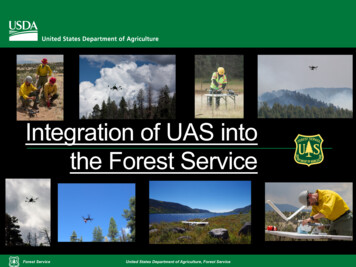
Integration of UAS intothe Forest ServiceForest ServiceUnited States Department of Agriculture, Forest Service
Presentation Topics Overview of FS UAS governance Recent UAS activities Current work and program support Vision and next stepsForest ServiceUnited States Department of Agriculture, Forest Service
FS UAS Program NeedUASProgramAgencyownedForest ServicePublic UseServiceProvidersUnited States Department of Agriculture, Forest Service
FS UAS Program OrganizationUAS Advisory Group-FS Staff AreasUAS ExecutiveSteering Committee-WO Staff/Directors Technical expert anduser communityrepresentation Facilitatescommunications andapplicationdevelopment Chief-level direction Provide broad policyrecommendationsForest ServiceUAS ProgramManager-WO F&AM Staff UASAG Chair Responsibility toenforce FSM Authority overcommunication toolsUnited States Department of Agriculture, Forest ServiceInteragency Fire UASSubcommittee-NWCG Members Qualifications Resource typing,ordering USFSRepresentation
Direction and Guidance - Highlights Public UAS Use: FAA maintains authority over all civil airspace FAR 101, PL 112-95 provides right to fly for hobby orrecreational use “In accordance with a community-based set of safetyguidelines ” (use must be defined by a nationwidecommunity-based organization) FAR 107 provides avenue for professional use by thepublic in coordination with land management (canalso cover hobby/recreational use) Special designations (Wilderness, TFRs) includerestrictionsForest ServiceUnited States Department of Agriculture, Forest Service
Direction and Guidance - Highlights Agency UAS Use: Policies must ensure UAS are “used appropriately tofurther our mission with public safety, privacy, andcivil rights safeguarded” – Chief’s Letter July 2016 Follow Aviation planning process for all flight activities RAO/UAS PM coordination, PASP, Operations Plan Privacy and PII must be addressed when conductingmissions and handling imagery and data (assume allcollected data contains it) – PM 2015-Feb-15 Additional USDA direction may be forthcoming Acquisition: All UAS are aircraft, must be acquiredIAW Aviation, Acquisition regulations (centralizedacquisition and property management) End-product contracts not centralized – follow AcquisitionguidanceForest ServiceUnited States Department of Agriculture, Forest Service
Examples of Recent FS sUAS Projects1. Placer River Trail Bridge Inspection / Chugach NF (June2015)2. North Fire Support / Cibola NF (June 2016)3. FHP/FM Aerial Survey / Apache-Sitgreaves NF (September2016)4. Eurasian Milfoil Mapping / Fishlake NF (September 2016)5. Blackjack/Bluebird Mine Aerial Survey / Umatilla NF (October2016)6. Riparian Monitoring Survey / Wallowa-Whitman NF (June2017)7. Champion Mine Aerial Survey / Umpqua NF (August 2017)8. Pioneer Post-Fire Aerial Survey / Boise NF (July 2017)9. Dinosaur footprint mapping / Comanche NG (November 2017& May 2018)Forest ServiceUnited States Department of Agriculture, Forest Service
What are the Currently Available Methods to UseUAS on NFS Lands? End Product Contracts - Focus is on the data needed. UAS cannotbe specified, but could be used to meet contract. Contract for Flight Services - Uses the same process and has thesame timeframe as contracting for manned aircraft. Additional contracting vehicles are currently being investigated, developed andimplemented NRCS UAS Services BPA F&AM CWN contract External Partners - Utilize UAS flight services from other agencies,partners and cooperators. Agreements required for all UAS flight services provided to the Forest Service. Aircraft and pilots need to be carded appropriately for the mission.Forest ServiceUnited States Department of Agriculture, Forest Service
Program Support For public use management: Public Affairssupport, LE&I engagement, Rec and Wilderness Ongoing coordination of policy and procedures Contracting UAS services: NIFC Incident SupportBranch (ISB) All UAS acquisition and contracted services under FSoperational control are managed by ISB UAS Program to develop standard language, deskguide to distribute to all contracting offices to ensurethat end-product contracts do not become aircraftservicesForest ServiceUnited States Department of Agriculture, Forest Service
Outreach and AssistancePublic AwarenessCampaignsForest ServiceUAS policy guidance andreference materials for FS staffUnited States Department of Agriculture, Forest Service
Strategic Vision To foster safe, legal, respectful andenjoyable use of UAS for the public onNational Forests To facilitate safe, efficient and cost-effectiveuse of UAS for Forest Service work whenUAS are the right tools for the job.Forest ServiceUnited States Department of Agriculture, Forest Service
Next Steps Enhanced internal outreach/education Agency-wide webinars Improved Web presence Summarize and split up guidance by application Establish a Program “toolkit” Durable, flexible resource sharing agreements withpartners Contracts for services, equipment Effective, available UAS training and missionrequest processForest ServiceUnited States Department of Agriculture, Forest Service
Next Steps Continuous Improvement Baseline needs metrics from recent FS NeedsAssessment survey Plan to meet identified needs Monitor performance through mandatory usereporting Periodically reassess needs and adjust planForest ServiceUnited States Department of Agriculture, Forest Service
Resources Internal FS UAS Website dex.htm Public-facing UAS Website ges/Home.aspxForest ServiceUnited States Department of Agriculture, Forest Service
Questions?Ryan BeckerForest Service UAS Program Manager (Detailed)Brad QuayleCourtesy of USGSForest ServiceForest Service UAS Advisory Group Co-ChairUnited States Department of Agriculture, Forest Service
5. Blackjack/Bluebird Mine Aerial Survey / Umatilla NF (October 2016) 6. Riparian Monitoring Survey / Wallowa-Whitman NF (June 2017) 7. Champion Mine Aerial Survey / Umpqua NF (August 2017) 8. Pioneer Post-Fire Aerial Survey / Boise NF (July 2017) 9. Dinosaur footprint mapping / Comanche NG (November 2017 & May 2018) 1 6 9