Transcription
tizensciencegis/http://twitter.com/citizen gisTraining Manual forFAA part 107 Remote PilotSmall Unmanned Aircraft SystemsJune 2019NSF drone eelgrass mapping project along the west coast of North AmericaFor questions, suggestions, or concerns, please contact:Dr. Bo YangUniversity of Central FloridaDr. Timothy L. Hawthorne
Bo.Yang@ucf.eduUniversity of Central FloridaTimothy.hawthorne@ucf.eduContents1 Become a Drone Pilot . 31.1 Eligibility . 31.2 Examination information . 31.3 Reference material. 32 Preparing the Examination . 42.1 Remember the numbers . 42.2 Weather sources and radio communication . 52.2.1 Weather . 52.2.2 Radio frequencies . 52.2.3 NOTAM (Notices to Airmen) . 62.2.4 METAR (Meteorological Aviation Report) . 62.2.5 TAF (Terminal Aerodrome Forecast) . 62.2.6 Pilot’s alphabet/Aviation alphabet . 62.3 Learn what is Airspace (Class A, B, C, D, etc.) . 62.4 Recognize the sectional charts . 92.4.1 sectional chart and legend . 92.4.2 Latitude and Longitude (Meridians and Parallels) . 102.5 Airplane physics and drone manipulations. 112.5.1 Load factor . 112.5.2 Emergency procedures . 112.5.3 Vision and Flight . 122.5.4 Risk Management . 123 Sample Questions . 12
1 Become a Drone PilotAccording to FAA.gov, in order to fly your drone under the FAA's Small UAS Rule (Part 107),you must obtain a Remote Pilot Certificate from the FAA. This certificate demonstrates that youunderstand the regulations, operating requirements, and procedures for safely flying drones.1.1 EligibilityTo become a pilot, you must: Be at least 16 years old Be able to read, speak, write, and understand English Be in a physical and mental condition to safely fly a drone Pass the initial aeronautical knowledge exam Must be easily accessible by the remote pilot during all UAS operations Valid for 2 years. Certificate holders must pass a knowledge test every two years1.2 Examination informationThe examination has 64 questions, and each question is 3 multiple answer question. Youneed to get more than 70% to pass the examination. You can bring full function calculator.You need to go to local site to take the test. For example, in Orlando, Call AVIATIONINSTITUTE OF MAINTENANCE -ORLANDO 2725 S. US HIGHWAY 17/92 (407) 896-2800 to schedulethe test. The site ID is: ORLANDO ABS32710Information can be obtained from the FAA by phone, Internet/e-mail, or mail. To talk to theFAA tollfree 24 hours a day, call 1-866-TELL-FAA (1-866-835-5322). To visit the FAA’s website, goto www.faa.gov. Individuals can also contact an FAA representative at faadronezone.faa.gov.1.3 Reference materialAlmost all reference material is available online at www.faa.gov in downloadable format.Commercial aviation publishers also provide published and online reference material to furtheraid the aviation pilot.
2 Preparing the ExaminationThis section we are going to learn the knowledge for preparing the drone examination. Includinglearn the airspace concepts, weather sources and radio communications, sectional charts, anddrone physics. Figures of this section are from FAA Small Unmanned Aircraft Systems StudyGuide.2.1 Remember the numbers 0.55Lbs Minimum UAS to register 55 maximum UAS to register 13 age to register 16 age to take the test License valid for 24 months 400 feet above ground, or 400 AGL above a structure (varies). 500 feet below clouds 2000 feet horizontally from clouds 2000 feet horizontally from guy wires 100 mph max speed 3 SM visibility 8 hours without alcohol 0.04 blood alcohol level 1 year after narcotic conviction 30 minutes within civil twilight (30 minute before/after sunset/sunrise) 500 minimum damage for FAA report, 10 days to file FAA report
2.2 Weather sources and radio communication2.2.1 Weather Density altitudeAs the density of the air increases (lower density altitude), aircraft performance increases.Conversely, as air density decreases (higher density altitude), aircraft performancedecreases. A decrease in air density means a high density altitude; an increase in airdensity means a lower density altitude. Density altitude has a direct effect on aircraftperformance. Fronts – divide weatherAs air masses move out of their source regions, they come in contact with other air massesof different properties. The zone between two different air masses is a frontal zone orfront. Across this zone, temperature, humidity and wind often change rapidly over shortdistances. Wind shear – sudden change of wind Structural icingTwo conditions are necessary for structural icing in flight: 1. The aircraft must be flyingthrough visible water such as rain or cloud droplets 2. The temperature at the point wherethe moisture strikes the aircraft must be 0 C or colder. TS life cycle – cumulus, mature, dissipatingIt is virtually impossible to visually detect the transition from one stage to another; thetransition is subtle and by no means abrupt. Furthermore, a thunderstorm may be acluster of cells in different stages of the lifecycle. Humidity – less visibility, more efficient Unstable air – hot & humid Stable air – poor visibility, steady rain Nimbus – big heavy cloud2.2.2 Radio frequencies CTAFA CTAF is a frequency designated for the purpose of carrying out airport advisory practiceswhile operating to or from an airport without an operating control tower. MultiCOM 122.9 or 122.95A MULTICOM frequency of 122.9 will be used at an airport that is non-towered and doesnot have a FSS or UNICOM. UNICOMMost non-towered airports will have a UNICOM frequency, which is usually 122.8. AWOS weather
2.2.3 NOTAM (Notices to Airmen) 1800WXBrief.com2.2.4 METAR (Meteorological Aviation Report)Example: METAR KGGG 161753Z AUTO 14021G26KT 3/4SM TSRA BR BKN008 OVC012CB18/17 A2970 RMK PRESFR UTC time Windspeed 3/4SM – visibility BKN008 – cloud cover 18/17 Celsius2.2.5 TAF (Terminal Aerodrome Forecast)Example: TAF KPIR 111130Z 1112/1212 TEMPO 1112/1114 5SM BR FM1500 16015G25KTP6SM SCT040 BKN250 FM120000 14012KT P6SM BKN080 OVC150 PROB30 1200/1204 3SM TSRABKN030CB FM120400 1408KT P6SM SCT040 OVC080 TEMPO 1204/1208 3SM TSRA OVC030CB Z – UTC time code KT – wind speed2.2.6 Pilot’s alphabet/Aviation alphabet Alpha Bravo Charlie Delta Echo 2.3 Learn what is Airspace (Class A, B, C, D, etc.)
Permission from ATCControlled airspace is a generic term that covers the different classifications of airspace anddefined dimensions within which air traffic control (ATC) service is provided in accordance withthe airspace classification. Controlled airspace that is of concern to the remote pilot is: Class B airspace: major airports.Class B airspace is generally airspace from the surface to 10,000 feet mean sea level (MSL) Class C airspace: small airports.Class C airspace is generally airspace from the surface to 4,000 feet above the airportelevation (charted in MSL) Class D airspace: very small airports.Class D airspace is generally airspace from the surface to 2,500 feet above the airportelevation (charted in MSL) Class E Airspace Class E airspace is the controlled airspace not classified as Class A, B, C,or D airspace. Uncontrolled Airspace Class G Airspace Uncontrolled airspaceClass G airspace is the portion of the airspace that has not been designated as Class A, B,C, D, or E. It is therefore designated uncontrolled airspace. Class G airspace extends fromthe surface to the base of the overlying Class E airspace. A remote pilot will not need ATCauthorization to operate in Class G airspace. Prohibited AreasProhibited areas contain airspace of defined dimensions within which the flight of aircraftis prohibited.
Restricted AreasRestricted areas are areas where operations are hazardous to nonparticipating aircraftand contain airspace within which the flight of aircraft, while not wholly prohibited, issubject to restrictions. Military Training Routes (MTR/IR/VFR)MTRs are routes used by military aircraft to maintain proficiency in tactical flying. Routesare identified as IFR (IR), and VFR (VR), followed by a number.
Military Operations Areas (MOAs)MOAs consist of airspace with defined vertical and lateral limits established for thepurpose of separating certain military training activities from IFR traffic.2.4 Recognize the sectional charts2.4.1 sectional chart and legend
Sectional charts are the most common charts used by pilots today. The charts provide anabundance of information, including airport data, navigational aids, airspace, and topography.Below is an excerpt from the legend of a sectional chart.When taking the exam, pay attention on the chart legend! Most of the information can belooked up on the legend. By referring to the chart legend, a pilot can interpret most of theinformation on the chart. A pilot should also check the chart for other legend information, whichincludes air traffic control (ATC) frequencies and information on airspace. These charts arerevised semiannually except for some areas outside the conterminous United States where theyare revised annually.2.4.2 Latitude and Longitude (Meridians and Parallels)The equator is an imaginary circle equidistant from the poles of the Earth. Circles parallelto the equator (lines running east and west) are parallels of latitude. They are used to measuredegrees of latitude north (N) or south (S) of the equator. The angular distance from the equatorto the pole is one-fourth of a circle or 90 . The 48 conterminous states of the United States are
located between 25 and 49 N latitude. Any specific geographical point can be located byreference to its longitude and latitude. Washington, D.C., for example, is approximately 39 Nlatitude, 77 W longitude. Chicago is approximately 42 N latitude, 88 W longitude.2.5 Airplane physics and drone manipulations2.5.1 Load factorTurns—the load factor increases at a terrific rate after a bank has reached 45 or 50 . Theload factor for any aircraft in a coordinated level turn at 60 bank is 2 Gs. The load factor in an80 bank is 5.76 Gs. The wing must produce lift equal to these load factors if altitude is to bemaintained.2.5.2 Emergency procedures A remote pilot is responsible for the safe operation of the small UA at all times. Before every flight, a remote pilot will conduct a preflight inspection of the aircraft. When a remote pilot does experience an inflight emergency, the pilot may take any actionto ensure that there is not a hazard to other people or property. PIC is responsible all the time. PIC can supervise other people to manipulate the drone. 2.4.3 Performance of Small UAV Increasing the temperature of a substance decreases its density. Pilots can expect thedensity to decrease with altitude.
As the water content of the air increases, the air becomes less dense, increasing densityaltitude and decreasing performance.2.5.3 Vision and FlightTo scan effectively, pilots must look from right to left or left to right. They should beginscanning at the greatest distance an object can be perceived (top) and move inward toward theposition of the aircraft (bottom). For each stop, an area approximately 30 wide should bescanned. The duration of each stop is based on the degree of detail that is required, but no stopshould last longer than 2 to 3 seconds. When moving from one viewing point to the next, pilotsshould overlap the previous field of view by 10 .2.5.4 Risk Management Anti-authorityAntidote: Follow the rules. ImpulsivityAntidote: Not so fast, think first. InvulnerabilityAntidote: It could happen to me MachoAntidote: taking chances is foolish ResignationAntidote: I’m not helpless. I can make a difference.3 Sample QuestionsThe FAA published the following 24 sample questions as study material for the RemotePilot Recurrent Knowledge Test. These questions represent the type of questions found on thetest, but are not actual test questions.1. A small UA causes an accident and your crew member loses consciousness. When do youreport the accident?A) No accidents need to be reportedB) When requested by the UA ownerC) Within 10 days of the accidentAs a Remote PIC, you are required to report a qualifying accident to the FAA within 10 days.This is really important. According to the FAA, an accident is defined as:
1) At least serious injury to any person. By serious, they mean injuries like a loss ofconsciousness, a skin laceration that requires suturing, a broken bone, or head trauma.2) Damage to any property (other than the small UA) if the cost is greater than 500 toeither repair or to replace the property, whichever number is lower.If either of these two conditions is met, the accident report must be made within 10 calendardays of the operation that created the injury or damage. It can either be submittedelectronically at http://faa.gov/uas, by calling your FAA Regional Operations Center (ROC) or bycalling or visiting your nearest jurisdictional Flight Standards District Office (FSDO).2. A small UA must be operated in a manner whichA) does not endanger the life or property of anotherB) requires more than one visual observerC) never exceeds 200 feet AGLIt goes without saying that no person may operate an sUAS in a careless or reckless mannerthat endangers another person’s life or property. This has been the primary principle cited bythe FAA in many of its investigations and enforcement actions.3. You plan to release golf balls from your small UA at an altitude of 100 feet AGL. You mustensure the objects being dropped willA) not create an undue hazard to persons or propertyB) land within 10 feet of the expected landing zoneC) not cause property damage in excess of 300It goes without saying that no person may operate an sUAS in a careless or reckless mannerthat endangers another person’s life or property. This has been the primary principle cited bythe FAA in many of its investigations and enforcement actions.This is a good example of a question where the most conservative/safest answer choice is thecorrect one.4. After having dinner and wine, your client asks you to go outside to demonstrate the smallUAs capabilities. You mustA) pass a self-administered sobriety test before operating a small UAB) not operate a small UA within 8 hours of consuming any alcoholic beverage
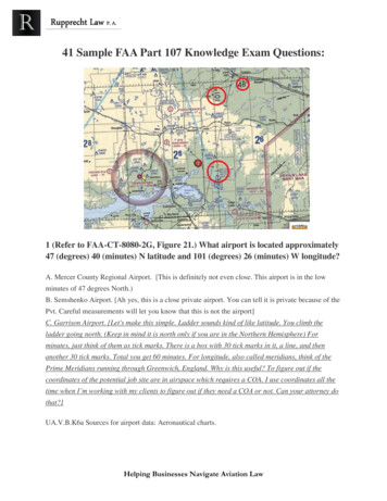
C) ensure that your visual observer has not consumed any alcoholic beverage in the previous 12hoursThe Part 107 regulations state that the pilot’s blood alcohol level needs to be less than .04percent, and at least 8 hours need to pass between drinking alcohol and piloting an unmannedaircraft (or taking part as another crewmember).A remote pilot with a blood alcohol level of .04 percent or greater after 8 hours cannot fly untilthe blood alcohol falls below that amount. Even though blood alcohol may be well below .04percent, a pilot cannot fly sooner than 8 hours after drinking alcohol. Although the regulationsare quite specific, it is a good idea to be more conservative than the regulations.5. During a flight of your small UA, you observe a hot air balloon entering the area. You shouldA) yield the right-of-way to the hot air balloonB) ensure the UA passes below, above, or ahead of the balloonC) expect the hot air balloon to climb above you altitudeWhen it comes to other larger aircraft you might encounter, from helicopters to gliders,powered parachutes, and balloons, you and your sUAS should yield right of way.6. (Refer to FAA-CT-8080-2H, Figure 78.) You have been hired to use your small UAS to inspectthe railroad tracks from Blencoe (SE of Sioux City) to Onawa. Will ATC authorization berequired?A) Yes, Onawa is in Class D airspace that is designated for an airportB) No, your entire flight is in Class G airspaceC) Yes, you must contact the Onawa control tower to operate within 5 miles of the airportOnce you’ve identified Blencoe and Onawa in the southeastern part of the map, you’ll noticethat there’s no controlled airspace between both locations. It’s Class G airspace from theground up to 1,200 ft. AGL, and no permission is required during your flight operation.7. According to 14 CFR part 107, what is the maximum groundspeed for a small UA?A) 87 knotsB) 87 mphC) 100 knots
Under Part 107, a Remote Pilot-in-Command cannot fly an unmanned aircraft faster than 100mph, or 87 knots.8. (Refer to FAA-CT-8080-2H, Figure 78.) You have been contracted to inspect towers locatedapproximately 4NM southwest of the Sioux Gateway (SUX) airport operating an unmannedaircraft. What is the maximum altitude above ground level (AGL) that you are authorized tooperate over the top of the towers?A) 400 Feet AGLB) 402 feet AGLC) 802 feet AGLThis is a great question. After locating Sioux Gateway (SUX) airport, you can use the scale at thebottom of the Sectional Chart excerpt to measure 4NM southwest. You should see a clusterobstruction / tower icon with two heights being shown, 1,498 ft. MSL and 402 ft. AGL.So the topmost part of the highest tower in that cluster sits at 402 ft. AGL and remember thatunder the Part 107 regulations, you’re allowed to fly up to 400 ft. over the topmost part of thetower. So the correct answer is 402 400 802 feet AGL.9. Upon request by the FAA, the remote pilot-in-command must provideA) a logbook documenting small UA landing currencyB) a remote pilot certificate with a small UAS ratingC) any employer issued photo identificationAt the end of the day, any officer of the FAA (that includes law enforcement) is allowed to makeany test or inspection of what you’re up to. The unmanned aircraft system, the remote PIC,your visual observer, your flight logs, and any other documents, records, or reports need tocomply with the applicable FAA regulations. You name it — they can check it.This question is somewhat tricky. While you’re technically supposed to be keeping a logbook,the “landing currency” phraseology is more fit for manned aircraft pilots, who have to maintaina minimum number of flights to keep their license current. The more correct choice is “aremote pilot certificate with a small UAS rating.”10. The refusal of a remote PIC to submit to a blood alcohol test when requested by a lawenforcement officer
A) is grounds for suspension of revocation of their remote pilot certificateB) can be delayed for a period up to 8 hours after the requestC) has no consequences to the remote pilot certificateYou can lose your remote pilot certificate and/or not be allowed to apply for a certificate in thefirst place for up to one year if there’s been any recent federal or state alcohol or drugviolations. That includes refusing to submit to a blood alcohol test.11. (Refer to FAA-CT-8080-2H, Figure 25, Area 3.) The floor of Class B airspace at DallasExecutive (RBD) isA) at the surfaceB) 3,000 feet MSLC) 3,100 feet MSLDallas Executive (RBD) sits in Class D airspace from the surface up to 3,000 ft. MSL (blue-dashedlines), and then at 3,000 ft. MSL, it becomes Class B airspace. We know this because of the110/30 fraction next to the airport icon. This indicates that in this closed-off part of the bluesolid Class B lines, this particular area of Class B airspace starts at 3,000 ft. MSL and goes up to11,000 ft. MSL.12. (Refer to FAA-CT-8080-2H, Figure 23, Area 3.) What is the floor of the Savannah Class Cairspace at the shelf area (outer circle)?A) 1,300 feet AGLB) 1,300 feet MSLC) 1,700 feet MSLFirst, identify both the inner circle and outer magenta solid line circles around Savannahairport. Then, look for the fraction that shows 41/13. This indicates that in this outer portion ofClass C airspace, the floor of the airspace is 1,300 ft. MSL, and the ceiling of the airspace is4,100 ft. MSL.13. (Refer to FAA-CT-8080-2H, Figure 78. Near the center of the figure.) What class of airspaceis associated with SIOUX GATEWAY/COL DAY (SUX) Airport?
A) Class B airspaceB) Class C airspaceC) Class D airspaceWe know that SIOUX GATEWAY/COL DAY (SUX) Airport sits in Class D airspace because of theblue-dashed circle around the airport. Remember that Class D airspace always starts at thesurface, and you can look at the number in the brackets to see what height the Class D airspacegoes up to.14. (Refer to FAA-CT-8080-2H, Figure 20, Area 1.) The Fentress NALF Airport (NFE) is in whattype of airspace?A) Class CB) Class EC) Class GWe know that Fentress NALF Airport (NFE) sits in Class E airspace because of the magentadashed circle around the airport. This indicates Class E airspace starting at the surface.15. (Refer to FAA-CT-8080-2H, Figure 75, Area 6.) During preflight planning, you plan to operatein R-2305. Where would you find additional information regarding this airspace?A) In the Aeronautical Information ManualB) In the Charts Supplements U.S.C) In the Special Use Airspace area of the chartR-2305 is a Restricted Area. More information about Restricted Areas can be found on theborder of a Sectional Chart. There’s a lot of information that is shared in the border, including aSpecial Use airspace section for areas like R-2305.16. (Refer to FAA-CT-8080-2H, Figure 21.) You have been hired by a farmer to use your small UAto inspect his crops. The area that you are to survey is in the Devil s Lake West MOA, east ofarea 2. How would you find out if the MOA is active?A) Refer to the chart legendB) This information is available in the Small UAS databaseC) Refer to the Military Operations Directory
An MOA is a Military Operating Area. More information about MOAs can be found on theborder of a Sectional Chart. You’ll see information like the name of the MOA, the operatingaltitude and time of use, the radio frequency and the controlling agency/contact facility thatmanages the MOA.17. (Refer to FAA-CT-8080-2H, Figure 23, Area 4.) What is the required flight visibility for aremote pilot operating an unmanned aircraft near the Plantation Airport (JYL)?A) 5 statute milesB) 1 statute mileC) 3 statute milesThis is kind of a trick question. You can’t find visibility requirements on a sectional chart. Theminimum visibility for any sUAS operations is always 3 statute miles (SM), no matter where youare flying. It’s a regulations question, not a sectional chart question. The chart is a red herringmeant to throw you off. We’re not huge fans of this question, but this is a good representationof the kind of trickery you may experience on the FAA’s Aeronautical Knowledge Test.18. (Refer to FAA-CT-8080-2H, Figure 21, Area 1.) After receiving authorization from ATC tooperate a small UA near Minot International airport (MOT) while the control tower isoperational, which radio communication frequency could be used to monitor manned aircraftand ATC communications?A) UNICOM 122.95B) ASOS 118.725C) CT-118.2The radio frequency that sUAS operators can tune into to listen to manned aircraft chatter fromincoming or outgoing pilots is called the Common Traffic Advisory Frequency (CTAF).The CTAF frequency is always going to be to the left of the circle C icon.After locating the Minot International airport (MOT) icon on the chart, look for the airportinformation text next to the icon. Remember that in the testing supplement legend, you’reactually being told exactly where a lot of information is on the Sectional Chart.In this example, the CTAF is 118.2, which also happens to be the Control Tower frequency.That’s why you’re seeing “CT” in the answer choice instead of “CTAF.”
19. (Refer to FAA-CT-8080-2H, Figure 24, Area 6.) What type of airport is Card Airport?A) Public toweredB) Public non-toweredC) Private non-toweredDo you see the “PVT” next to the name of the airport? This indicates that CARD Airport is aprivate airport. And the magenta coloring means that this is a non-towered airport.20. (Refer to FAA-CT-8080-2H, Figure 20, Area 4.) A small UA is being launched 2 NM northeastof the town of Hertford. What is the height of the highest obstacle?A) 399 feet MSLB) 500 feet MSLC) 500 feet AGLOnce you find Hertford — you’ll see the text on the chart, as well as yellow shading whichindicates population density — use the scale at the bottom of the Sectional Chart excerpt tomeasure 2 NM northeast. You’ll see a few different tower icons the highest one is either 514ft. MSL or 500 ft. AGL. Since the AGL choice is being offered as an answer, that’s the correctone.21. (Refer to FAA-CT-8080-2H, Figure 24, Area 3, and Legend 1.) For information about theparachute operations at Tri-County Airport, refer toA) notes on the border of the chartB) Chart Supplements U.S.C) the Notices to Airmen (NOTAM) publicationThe Chart Supplement U.S., formerly called the Airport/Facility Directory, provides the mostcomprehensive information on a given airport. It contains information on airports, heliports,and seaplane bases that are open to the public. It’s published across seven books, and theinformation in each of these books is updated every couple of months. You can access thesecharts digitally by using a tool like http://skyvector.com and clicking into the airport icon.Chart Supplements are great for learning more about things like parachute drop zones or glideroperations, traffic pattern information, operating hours, noise abatement, and really any otherinformation about an airport that doesn’t fit into the nice and colorful Sectional Chart. It’s agreat resource to keep in your back pocket when doing airspace research and flight missionplanning.
22. What precautions should a remote PIC do to prevent possible inflight emergencies whenusing lithium-based batteries?A) Store the batteries in a freezer to allow proper rechargingB) Follow the manufacturer’s recommendations for safe battery handlingC) Allow the battery to charge until it reaches a minimum temperature of 100 CAlways store your LiPo batteries in a cool, dry place. Shoot for room temperature. Do not storethem in a hot garage or in a refrigerator or freezer.This is a good example of where the most conservative answer choice is correct — “Follow themanufacturer’s recommendations for safe battery handling.” This is a much stronger choicecompared to the other two options.23. When a remote pilot-in-command and a visual observer define their roles andresponsibilities prior to and during the operation of a small UA is a good use ofA) Crew Resource ManagementB) Authoritarian Resource ManagementC) Single Pilot Resource ManagementThe definition of Crew Resource Management (CRM) is “the effective use of all availableresources—human, hardware, software and information—prior to and during flight to ensurethe successful outcome of the operation.”24. What actions should the operator of an sUAS do if the manufacturer does not provideinformation about scheduled maintenance?A) The operator should contact the FAA for a minimum equipment listB) The operator should establish a scheduled maintenance protocolC) The operator should contact the NTSB for component failure rates for their specific sUASIf your UA manufacturer does not provide a maintenance schedule, you’ll need to establishyour own scheduled maintenance protocol.
FAA part 107 Remote Pilot Small Unmanned Aircraft Systems June 2019 NSF drone eelgrass mapping project along the west coast of North America . Figures of this section are from FAA Small Unmanned Aircraft Systems Study Guide. 2.1 Remember the numbers 0.55Lbs Minimum UAS to register 55 maximum UAS to register 13 age to register