Transcription
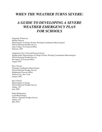
WHEN THE WEATHER TURNS SEVERE:A GUIDE TO DEVELOPING A SEVEREWEATHER EMERGENCY PLANFOR SCHOOLSOriginally Written byBarbara WatsonMeteorologist in Charge (Former Warning Coordination Meteorologist)NOAA/National Weather ServiceState College, PA Forecast OfficeFebruary 1995Adapted for New York and Pennsylvania byStephan Kuhl, Meteorologist in Charge (Former Warning Coordination Meteorologist)NOAA/National Weather ServiceDavenport, IA Forecast OfficeAugust 1997Dave NicosiaWarning Coordination MeteorologistNOAA/National Weather ServiceBinghamton Forecast OfficeJohnson City, New YorkJanuary 2003Ray O’KeefeMeteorologist in ChargeNOAA/National Weather ServiceAlbany, NYJune 2005Brian MontgomeryLead MeteorologistNOAA / National Weather ServiceAlbany, NYMay 2018
TABLE OF CONTENTSINTRODUCTIONA. The Mission StatementB. What to Expect from This GuideC. Choosing a Severe Weather CoordinatorSECTION 1 - Severe Weather ThreatsA.B.C.D.E.F.Hazardous Weather OutlookLightningFlash FloodingSevere FloodingWinter WeatherConclusionsSECTION 2 - Designing Your Severe Weather Emergency PlanA.B.C.D.E.F.G.How to Get Emergency Weather InformationGetting the Message Out to Students and StaffDetermining Severe Weather Safety Zones in Your SchoolWhen to Activate Your Plan and When to Return to Normal ActivitiesDetermining When to Delay Departure of StudentsSchool Bus Driver ActionsNeed for Periodic Exercises and Severe Weather Safety InstructionSECTION 3 - Designing Your Winter Weather Emergency PlanA.B.C.D.E.F.How to Get Winter Weather InformationAlerting Students and Staff to Take ActionDetermining When to Activate Your PlanDetermining When to Cancel or Delay ClassesSchool Bus ActionsNeed for Winter Weather Safety InstructionAPPENDIX A – Severe Weather Safety Plan ChecklistAPPENDIX B – Web sites of interest2 Page
THE MISSION STATEMENTNational Weather ServiceThe National Weather Service (NWS), under the National Oceanic and AtmosphericAdministration (NOAA) and the Department of Commerce (DOC), is responsible forproviding weather decision support services to the Nation. It is charged with theresponsibility of observing and reporting the weather and with issuing forecasts andwarnings of weather and floods in the interest of national safety and our economy.Briefly, the priorities for the Weather Service to the Nation are:1. Protection of life,2. Protection of property, and3. Promotion of the nation's welfare and economy.A partnership between the NWS and local school districts is essential to ensure thatstudents and teachers are informed and prepared to take action when severeweather threatens. The information in this guide will assist you in using NWSproducts and resources to develop a severe weather emergency plan for yourschool.What to Expect From this GuideThe purpose of this guide is to provide assistance to school administrators andteachers in designing a severe weather emergency plan for their school. While notevery possible situation is covered by this guide, it will provide enough information toserve as a starting point and a general outline of actions to take. The majority ofmaterial focuses on thunderstorms and the hazards these storms produce –damaging winds, lightning, hail, tornadoes, and flash floods. We have also includeda section on the risks of winter weather. To ensure safety, actions must be takenquickly.This will become more apparent in Section 1, "Severe Weather: Understanding YourRisks and the Importance of a Plan". Once you comprehend the scope of theproblem, you can begin to address how to reduce the potential hazard. Sections 2and 3 of this guide, "Designing Your Severe Weather Emergency Plan" and"Designing Your Winter Weather Emergency Plan", detail more specifically how to3 Page
get weather information, how teachers and students can be alerted to theemergency, and what actions under what circumstances should be taken to reducethe danger. Appendix A – Severe Weather Safety Plan Checklist offers a quickreview of key points in this document. Safety is always the foremost concern. Theultimate goal is to quickly inform teachers and students anywhere on the schoolgrounds of the threat of severe weather and to move them as quickly as possible topre-designated shelters. These sections also discuss school bus driver actions insevere weather.For any plan to work efficiently, it must be practiced!! Schools should conductsemi-annual exercises and severe weather safety instruction should be a part ofthese exercises. It is important to understand why certain actions are being taken.Choosing a Severe Weather CoordinatorBefore you begin, it is recommended that one person or group be designated as the"Severe Weather Coordinator(s)". This person(s) may be a teacher or administratorwith an interest in weather, who is willing to attend local NWS spotter trainingprograms (no fees). The coordinator will be responsible for developing the plan andworking with the local school board, administrators, and teachers to implement theplan. To ensure a successful plan, it is imperative that the coordinator has thesupport and active involvement of both the school board and the schooladministration.The National Weather Service Weather Ready Nation initiative is about readyingyour community and schools for extreme weather, water, and climate events. Moreinformation can be found at: https://www.weather.gov/wrn/.To find out more about NWS spotter training, contact Mr. Steve DiRienzo, WarningCoordination Meteorologist, National Weather Service, Albany NY.Email: Stephen.Dirienzo@noaa.govPhone: (518)435-95684 Page
SECTION 1:SEVERE WEATHER THREATSA.Hazardous Weather OutlookEach day between 4 am and 7 am the National Weather Service in Albany issues aHazardous Weather Outlook (HWO). This product discusses the potential for severeweather (flooding, severe thunderstorms, winter storms, etc.) over the next sevendays. School administrators should review the Hazardous Weather Outlook daily.The Outlook can be heard on NOAA Weather Radio and viewed on the NWS Albanywebsite: weather.gov/Albany under 'Current Hazards' tab above the map.B.LightningEastern New York and Western New England average about 25 to 30 thunderstormdays per year. By definition, a thunderstorm contains lightning. Lightning is a threatto anyone outdoors – the softball team on the field, the band practicing, fans in thestand, kids on the playground, etc. The National Weather Service does not issuewarnings for lightning alone. When thunderstorms are observed, keep theselightning safety tips in mind: If you can hear thunder, you are close enough to the storm to bestruck! When Thunder Roars Go Indoors or See a Flash, Dash Inside.Thunderstorms extend 5 to 10 miles into the atmosphere. Winds aloft canblow the upper portion (anvil) of the storm many miles downstream.Lightning can come out of the side or anvil of the storm striking the ground 10to 20 miles away from the rain portion of the cloud. 30-30 Rule - Determine the threat of lightning in your area.o 30 Seconds: Count the seconds between seeing lightning andhearing thunder. If this time is less than 30 seconds, lightning is still apotential threat. Seek shelter immediately.o 30 minutes: After the last lightning flash, wait 30 minutes beforeleaving shelter. Half of all lightning deaths occur after the stormpasses. Stay in a safe area until you are sure the threat has passed.C.Flash FloodsFlash flooding is the rapid rise – usually six hours or less – of water along a streamor low lying urban area. On average, about 30 flash flood events occur acrossEastern New York and Western New England every year. These flash floods occurin every season. Eastern New York and Western New England’s topographycombined with winter ice jams, spring snowmelt, summer thunderstorms, andautumn tropical systems make the region particularly susceptible to flash flooding.5 Page
When there is the possibility of flash flooding, the National Weather Service willissue a Flash Flood Watch. A Watch means conditions are favorable for flashflooding. You should continue with your daily routine, but know what to do if a FlashFlood Warning is issued. A Flash Flood Warning means the flooding is imminent oroccurring. Take action now to protect your life and property!Flooding is a weather-related killer, averaging 150 deaths per year nationally. Halfof these deaths occur in automobiles. NEVER ENTER FLOODED WATERS! Ifcaught in rising water, abandon your vehicle immediately and move to higherground. Turn Around, Don’t Drown!D.Severe WeatherSevere thunderstorms are those storms which produce winds of 58 mph or greaterand/or hail of 1 inch in diameter or larger. Tornadoes are violently rotating columnsof air attached to the cloud base above and in contact with the ground below. Onaverage, Eastern New York and Western New England can expect about 100-150severe weather events per year, and three or four tornado events per year. Keep inmind, that although most common during the warm weather months, severe weathercan strike during any season. In late February 2016, severe thunderstorms movedacross Eastern New York and Western New England!If conditions are favorable for severe weather, the National Weather Service willissue either a Severe Thunderstorm Watch or Tornado Watch. Again, a Watchmeans severe weather is possible. Continue with your daily routine but be alert forthe issuance of a severe thunderstorm warning. A Severe Thunderstorm Warning orTornado Warning means that severe thunderstorms or tornadoes respectively areimminent or occurring. Take cover now to protect life and property!E.Winter WeatherExtreme winter weather takes a toll on lives and property throughout many portionsof the United States. Heavy snow and freezing rain are responsible for numeroustraffic fatalities each year. Moreover, hundreds of deaths and injuries fromhypothermia, exposure, and frostbite are reported each year as bitter cold airmasses plunge into the United States during the winter. Many people are still injuredor killed despite a long history of extreme winter weather activity in our region. Of allwinter deaths related to ice and snow, 70 percent occur in motor vehicle accidentsand 25 percent are people caught out in the storm. Heavy Snow Storms - We all know that heavy snow can immobilize a regionand paralyze a city, stranding commuters, stopping the flow of supplies, anddisrupting emergency and medical services. Accumulations of snow cancollapse buildings and knock down trees and power lines. When snow isaccompanied by wind, travel becomes even more hazardous. School bus6 Page
routes may be blocked by drifting snow and travel may be hindered by nearwhiteout conditions. Often times, bus service is delayed or unavailable. Lake Effect Snow - Lake effect snow is one particular type of winter stormcommon to the snow belt regions of New York (just downwind of the GreatLakes). Lake effect snow occurs when cold air rushes across the warmwaters of the Great Lakes, initiating snow showers and squalls. In theprimary snow belt, seasonal accumulations are often well over 100 inches. Ice Storms - Heavy accumulations of ice can bring down trees, utility lines,and communication towers, blocking roads and causing power outages.Roadways become a glaze of ice and nearly impassable. Again, schoolbuses may be delayed or unavailable. Extreme Cold - Extremely cold temperatures often accompany a winterstorm or are felt in its wake. Prolonged exposure can cause frostbite orhypothermia and can become life threatening. This is a problem especiallyfor children waiting at bus stops or at outdoor recess. When extremely coldtemperatures are accompanied by wind, an especially dangerous situationexists. The Wind Chill is based on the rate of heat loss from exposed skincaused by the combined effects of wind and cold. As the wind increases,heat is carried away from the body at an accelerated rate, driving down thebody temperature, leading to frostbite and/or hyperthermia.F.ConclusionThe goal of this publication is to ensure that every student's safety is adequatelyaccounted for when the weather turns severe. It has been well documented thatsevere thunderstorms and dangerous winter weather occur in Eastern New York andWestern New England. If your school has never experienced severe weather, donot conclude that severe weather will never place your school in danger. A delay indeveloping a severe weather emergency plan could be a painful lesson. Onlythrough preparedness before the storm, can the safety of all school children andpersonnel be assured. Please get prepared now and use this guide to help youdevelop a severe weather emergency plan for your school. If you need anyassistance or have questions, please contact Mr. Steve DiRienzo, WarningCoordination Meteorologist, National Weather Service, Albany, NY.7 Page
SECTION 2:DESIGNING YOUR SEVERE WEATHEREMERGENCY PLANA.How to Get Emergency Weather InformationBecause severe weather can occur with little, if any, warning, minutes and evenseconds can mean lives saved. In just five minutes, a tornado may travel two to fourmiles on the ground. From the time the National Weather Service (NWS) issues awarning, to the time you receive that warning via radio or television, several minutesmay have elapsed. Also, you must be listening at the critical moment that thewarning is announced or an even greater amount of time will pass!NOAA Weather RadioThe fastest, most accurate and reliable means of receiving critical weatherinformation at your school is through a NOAA Weather Radio with a “tone alert”feature. Make sure your NOAA Weather Radio has a battery backup. NOAAWeather Radio is operated directly from NWS offices and is part of our country'sNational Warning System. When the NWS issues a warning, a Specific AreaMessage Encoder (SAME) unit triggers a "tone alert" (1050 Hertz). This alert isimmediately followed by warning information.The NOAA Weather Radio "tone alert" feature is used for the issuance of all shortfused weather information such as severe thunderstorm, flash flood, and tornadowatches and warnings. NOAA Weather Radio broadcasts 24 hours a day, sevendays a week with the latest weather information, from daily forecasts to specialweather statements about sudden shifts in the weather patterns or the developmentof potentially hazardous weather.If your school is not in a reliable NOAA Weather Radio listening area (due tointerference from mountains or other sources), then below are some suggestedalternatives:-Wireless Apps and BroadcastingComputers and wireless devices can also receive warnings. The NationalWeather Service, Red Cross, state emergency management agencies andFEMA have wireless applications that will alert you of severe weather byrelaying National Weather Service warnings.-iNWSInteractiveNWS (iNWS) is the home of new mobile and desktop innovations8 Page
of the National Weather Service. This application suite allows NWS partnersand decision makers to receive National Weather Service products in newand innovative ways, such as text messaging and mobile-enabled web pages.iNWS strives to fulfill our mission of protecting life and property by using newtechnology to reach out to our customers. https://inws.ncep.noaa.gov/- New York, Vermont, Massachusetts and Connecticut AlertsAs wireless technology continues to expand, state governments are offering afree service to receive text alerts. These services are free to join as you canreceive warnings and emergency information via the web, your cell phone,email and other technologies.https://www.nyalert.gov/ http://www.ct.gov/ctalert alert- The Weather ChannelIf you have cable television access, The Weather Channel uses NWSproducts and broadcasts warnings and statements immediately upon receiptfrom the NWS via a satellite link. They also display local radar picturesthroughout the day.- Primary Emergency Alert System (EAS) StationMonitor your primary (EAS) radio station. EAS operates on a cooperativeagreement between broadcasters and federal, state, and local governmentagencies.- Local or Cable TelevisionMonitor your local or cable television stations. Many television stations haveaccess to NWS products and will immediately post (i.e., scroll) a watch orwarning when it is issued.Phone call-down systems or calling-trees are not advised for receipt of warninginformation due to: 1) time elapsed in relaying information; 2) chance of incorrect orincomplete information being passed; 3) lack of reliability of phone systems duringstorms; and, 4) the NWS advises people not to use corded telephones during anelectrical storm due to the lightning hazard.Your radio or television should be located in the main office or near the person(s)responsible for enacting the plan. Keep in mind that the main office may not be thebest place for a NOAA Weather Radio during evening and weekend cultural andsporting events. Here the best place is usually at the event site – the football field orauditorium. If using a NOAA Weather Radio, the radio should be set at all times in"Alert" mode. Some radios will automatically turn on when an alert sounds, while9 Page
others must be manually turned on. It is better to have the type that automaticallyturns on in case you are out of the room when the tone is activated. If using NOAAWeather Radio, the information cycles every few minutes, so if you don't hear all theinformation you need the first time through, it will repeat shortly. You can alsoreview warnings at the NWS Albany internet site – weather.gov/Albany .Listen for the type of watch or warning and where it is in effect. The person(s)monitoring must know what action they should take based on this information. Havea map nearby for easy reference to counties and towns to locate storms and theirmovement in reference to your school. There is no need to take emergency action ifthe warning is not for your location. It should, however, heighten your awareness tothe potential for severe weather in your school district, especially if the warning is fora county next to you and the storms are moving in your direction!B.Getting the Message Out to Students and StaffMost schools utilize a public address (PA) system to talk directly to students andteachers. In some cases, electricity may be lost during a storm before you haveactivated your plan. Therefore, it is critical to have a back-up alerting device such asa megaphone.If your school has mobile classrooms or detached gymnasiums that are not part of aPA or intercom system, then special arrangements should be made to notifystudents and staff in these areas. Sending "runners" outside to mobile classroomsis not advisable due to the danger posed by lightning and the approaching storm.Wireless communication devices are an effective means for such communication."Walkie-talkies" may be the least expensive.Persons with disabilities may require special attention. You may want to assign astaff member to each person requiring special attention to see that the studentmoves to the appropriate place of safety. Students or staff that may not hear thewarning must be taken into account. To ensure appropriate action andunderstanding of your "call to action," you must exercise your plan.C.Determining Severe Weather Safety Zones in Your SchoolThis may be the most time consuming and complex phase of designing your plan.Schools are sufficiently complex and diverse in design that it is impossible todescribe an exact plan here that will apply to every school. Due to this complexity,it is recommended that this phase of the plan be accomplished with the helpof an engineer or architect familiar with the school's design. There are,however, general guidelines and basic concepts that can be discussed.The greatest dangers from high winds (e.g., tornado, thunderstorm downburst, etc.)are:1) roof failure;10 Page
2) breaking glass; and,3) flying debris (airborne missiles).The most dangerous locations are generally large rooms with big expansive roofssuch as cafeterias, gymnasiums, and auditoriums. The collapse of the room's loadbearing walls may lead to the failure of the entire roof. Roofs tend to rely on gravityto keep them attached. When strong winds act on a structure, pressure differencesare created, causing outward pressure forces, acting to lift the roof (see Diagram 1on next page). Rooms with large windows that may shatter from being struck byairborne missiles or from pressure stresses are extremely dangerous. Whilewindows on the side of the school facing the storm are most susceptible, anywindow could potentially shatter as the storm passes. Once winds enter a building,additional damage can create a domino effect. This is one of the reasons that “IT ISNO LONGER ADVISED THAT WINDOWS BE OPENED!!! Greater damage mayoccur from this action and valuable time that should be used getting to safetyis often lost.”Small interior rooms, bathrooms, and windowless, interior hallways that are awayfrom exterior doors offer the best protection. Interior load-bearing walls (with shortroof spans) provide better protection than temporary or non-load-bearing walls andstructures. If your school has a basement, move students to the basement. If yourschool has more than one story, evacuate the upper level of your school. Thelowest level is always the safest.11 Page
Diagram 1:Top diagram - Airflow around a structure.Bottom diagram - Airflow induces pressure on building components.Lengths of arrows are proportional to the magnitude of the force in thedirection indicated.Schools designed for the "open classroom" concept often lack safe areas due to alack of interior load-bearing walls, large spanning roofs, and the abundant use ofglass. You may not be able to find enough "ideal" space to protect your studentsand staff. It may be a matter of determining the lesser of evils. Below is a listbeginning with the lowest probability of failure:1) Interior, lower level, load-bearing walls (i.e., interior bathrooms or closets);2) Interior walls of upper level - exterior walls of lower level;3) Exterior walls of upper level - roof;4) Rooms with large roof spans - mobile classrooms; and,5) Windows on exterior walls.Fortunately, the majority of tornadoes will not destroy well-constructed buildings anddamage in about 70% of cases should not go beyond #2 listed above. With theseconsiderations, you may want to rank areas according to safety. Then begin byfilling the safest areas first with students and continue until you have found space foreveryone.12 Page
Again, it is best to have an engineer or architect advise your school on the safest areassince schools are built with varied designs and purposes. The priorities listed above arebased on broad generalities.D.When to Activate Your Plan and When to Return to Normal ActivitiesWhen activating a plan, you need as much information as possible about the type ofstorms, expected impact, and time of impact on your school district to assess therisk. A plan may work best with phases of activation. For instance, outdooractivities will be the most susceptible to weather hazards, with lightning being thegreatest threat. As soon as thunder is heard, not when the rain begins, outdooractivities should be stopped (When Thunder Roars, Go Indoors!). Outdoor activitiesshould not be resumed until the storm has passed. It is important not to resumeactivities simply because the rain has stopped or you no longer hear thunder. Sincelightning can strike far from the parent cloud, do not resume outdoor activities until30 minutes after thunder is last heard.Tornado or Severe Thunderstorm WatchIn a tornado or severe thunderstorm watch, outdoor activities may need to bepostponed. As a storm approaches, you may want to move students from the mostsusceptible areas such as mobile classrooms and gymnasiums as a precaution,even though a warning has yet to be issued. You may want to post a school officialtrained in spotting severe weather to watch the storm as it approaches. This personcan then advise when to take special actions. For severe weather spotter training,contact the NWS Albany Warning Coordination Meteorologist, Mr. Steve DiRienzo.Severe Thunderstorm WarningIf a severe thunderstorm warning is issued and your school is in the path of thestorm, all of the above actions are warranted. It is important to note that eventhough severe thunderstorm warnings are issued for a county, at times only a smallpart of a county is affected. That is why the NWS provides a storm path in the textof the warning (see example below). Action is only recommended if your school is inthe path of the storm. In addition to strong damaging winds, severe thunderstormsmay contain large hail and students should be moved out of areas with skylights. Ifyou have areas where large exterior windows may be exposed to the storm's winds,keep students out of these areas until the storm has passed. Below is an exampleof a severe thunderstorm warning from the NWS in Albany. Note the projectedstorm path (in bold) in the example 0001.170225T2013Z-170225T2115Z/BULLETIN - IMMEDIATE BROADCAST REQUESTEDSevere Thunderstorm WarningNational Weather Service Albany NY313 PM EST SAT FEB 25 201713 Page
The National Weather Service in Albany has issued a* Severe Thunderstorm Warning for.Western Fulton County in eastern New York.Southeastern Herkimer County in eastern New York.Northwestern Montgomery County in eastern New York.* Until 415 PM EST* At 312 PM EST, a severe thunderstorm was located near Cooperstown,moving northeast at 45 mph.HAZARD.60 mph wind gusts and penny size hail.SOURCE.Radar indicated.IMPACT.Expect damage to roofs, siding, and trees.* This severe thunderstorm will be near,Canajoharie, Fort Plain and St. Johnsville around 340 PM EST.Ephratah around 350 PM EST.Caroga Lake Public Campground and Caroga Lake around 400 PM EST.Other locations impacted by this severe thunderstorm include InghamMills, Meco, Cook Corners, Lotville, Rasbach Corner, Knappville,Mindenville, Davys Corners, Fical Corners and Shedd Corners.PRECAUTIONARY/PREPAREDNESS ACTIONS.For your protection move to an interior room on the lowest floor of abuilding.Hail and damaging winds and continuous cloud to ground lightning isoccurring with this storm. Move indoors immediately.Lightning is one of nature's leading killers. Remember, if you canhear thunder, you are close enough to be struck by lightning.Please report hail size.damaging winds and reports of trees down tothe National Weather Service by email at Alb.Stormreport@noaa.gov.On Facebook at www.facebook.com/nwsalbany or twitter @nwsalbany&&LAT.LON 4328 7473 4316 7426 4283 7464 4290 74884284 7489 4282 7491 4287 7501TIME.MOT.LOC 2012Z 220DEG 37KT 4276 7492HAIL.0.75INWIND.60MPHTornado WarningWhen a tornado warning is issued for your area and you have determined that yourschool is in the path of this storm, an “immediate and complete call to action" is14 Page
needed (see Tornado Warning example below). If the storm has not yet reachedyour school, begin moving students and staff from unsafe areas and post a trainedteacher or school employee to keep an eye on the storm’s approach. From yourexercises, you should know approximately how long it will take to move students into"tornado safe areas".To be on the safe side, it should take no more than two or three minutes to movestudents from upper floors to lower floors. Plan for the worst-case scenario – atornado is sighted nearby with little or no warning. During the storm, ensure allstudents and staff are in designated areas – and in the tornado safety position (seephoto).If winds begin to pick-up outside the school (or if a roar is heard or large hail isfalling), have students and teachers drop immediately into the “tornado safe” position(see diagram). Winds may increase at the onset of the storm and may or may notdrop off prior to the tornado. Rain may or may not be occurring. Large hail is asignal that you are near the part of the storm in which the tornado would most likelyoccur.Tornado warnings are issued for no more than 45 minutes. Sheltering wouldnormally be required for less than 45 minutes until the threat has passed. Once thestorm has passed, students may return to classrooms. Stay alert for the potential foradditional storms.One special consideration would be the complication of activating a full emergencyplan during class changes, when the halls are crowded and students may not knowwhere to go. It may be best to hold classes beyond regular dismissal time until thesevere weather threat has passed. Likewise, at the end of the school day, studentsmay need to be held from boarding buses until the danger has passed.You should have at least a couple of people who know how to shut off the mainpower (electricity) and gas (if applicable). After a tornado or severe thunderstorm, itmay be necessary to shut off the gas and electric supply to the building.15 Page
Tornado Safety PositionAdditional information from the Storm Prediction Center (SPC) can be reviewed elow is an example of a tornado warning issued by NWS Albany:Image of a Tornado Warning polygon (red 1.170531T2314Z-170531T2345Z/BULLETIN - EAS ACTIVATION REQUESTEDTornado WarningNational Weather Service Albany NY714 PM EDT WED MAY 31 2017The National Weather Service in Albany has issued a* Tornado Warning for.Southwestern Litchfield County in northern Connecticut.Southeastern Dutchess County in east central New York.* Until 745 PM EDT* At 714 PM EDT, a severe thunderstorm capable of producing a tornadowas located near Hopewell Junction, or 7 miles northwest ofPawling, moving southeast at 25 mph.16 Page
HAZARD.Tornado and half dollar size hail.SOURCE.Radar indicated ro
Eastern New York and Western New England average about 25 to 30 thunderstorm days per year. By definition, a thunderstorm contains lightning. Lightning is a threat to anyone outdoors - the softball team on the field, the band practicing, fans in the stand, kids on the playground, etc. The National Weather Service does not issue